
Good morning, East Tennessee!
Happy Thursday, and thanks for checking in with your local eastTNweather update.I’m meteorologist Mike Witcher, and once again we’re waking up to another gorgeous start across Knoxville, the Tennessee Valley, the Cumberland Plateau, and the Smoky Mountains.
Today’s weather is brought to you by a surface ridge of high pressure anchored right over Tennessee. That’s been the dominant feature of our week so far, and it’s the reason we’ve had crisp mornings, sunshine-filled afternoons, and cooler-than-average highs. But above us in the mid and upper levels of the atmosphere, the setup is a bit more complex:
-
A low pressure system to our north
-
A ridge of high pressure to our south and southwest
-
And a northwest flow pattern that continues to feed disturbances around that ridge
One of those disturbances will swing south and east today, sending just a few thin, high clouds across the region. Other than that, no rainfall is expected—just another beautiful day in East Tennessee.
Morning Temperatures: A Touch Warmer Than Yesterday
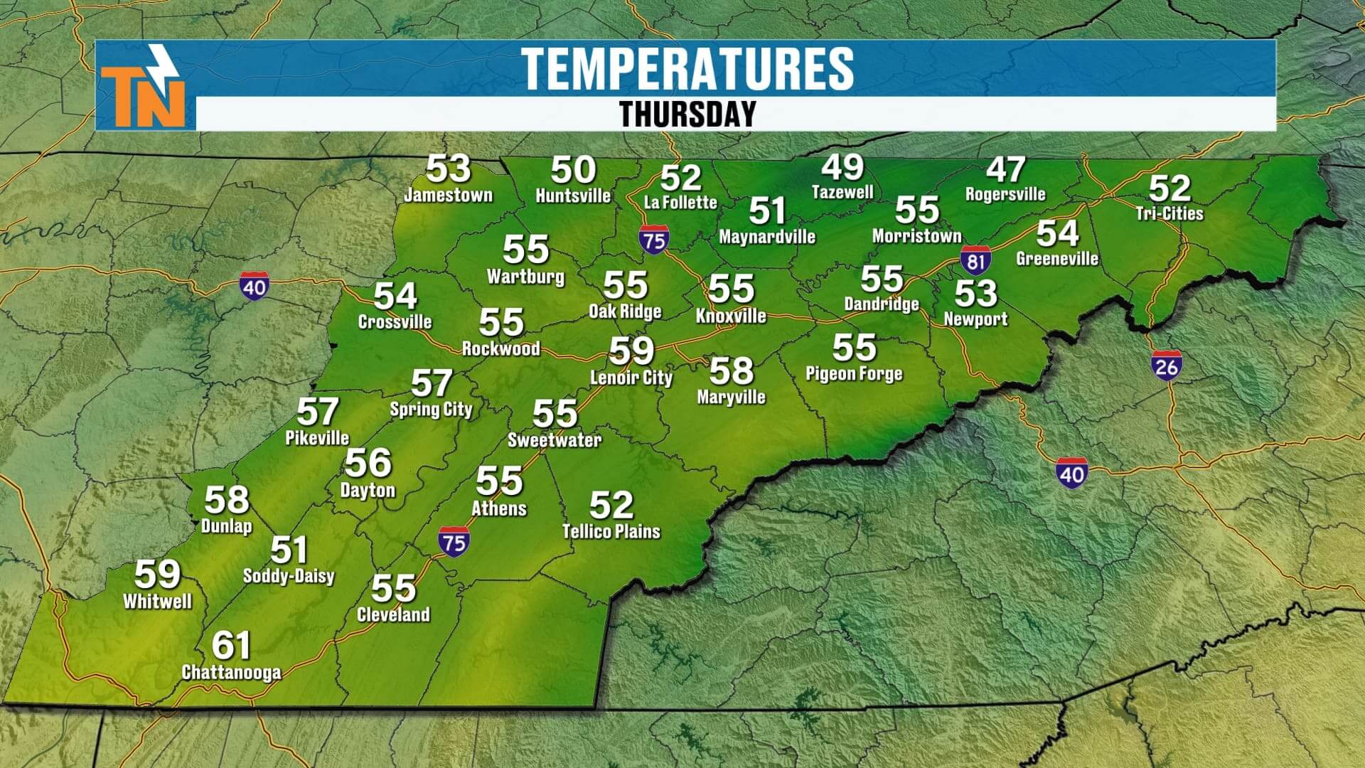
While we’ve been enjoying chilly starts in the 40s and 50s earlier this week, this morning is running just a bit milder. Low to mid-50s across the Plateau and Smokies, with upper 50s to near 60° across Knoxville and the Valley. It’s still cool enough for a light jacket, but the slight warm-up is a sign of what’s ahead.
Today’s Forecast: Sunshine, a Few High Clouds, and A Perfect Evening Ahead
-
Morning: Mostly clear skies with just a few high thin clouds overhead.
-
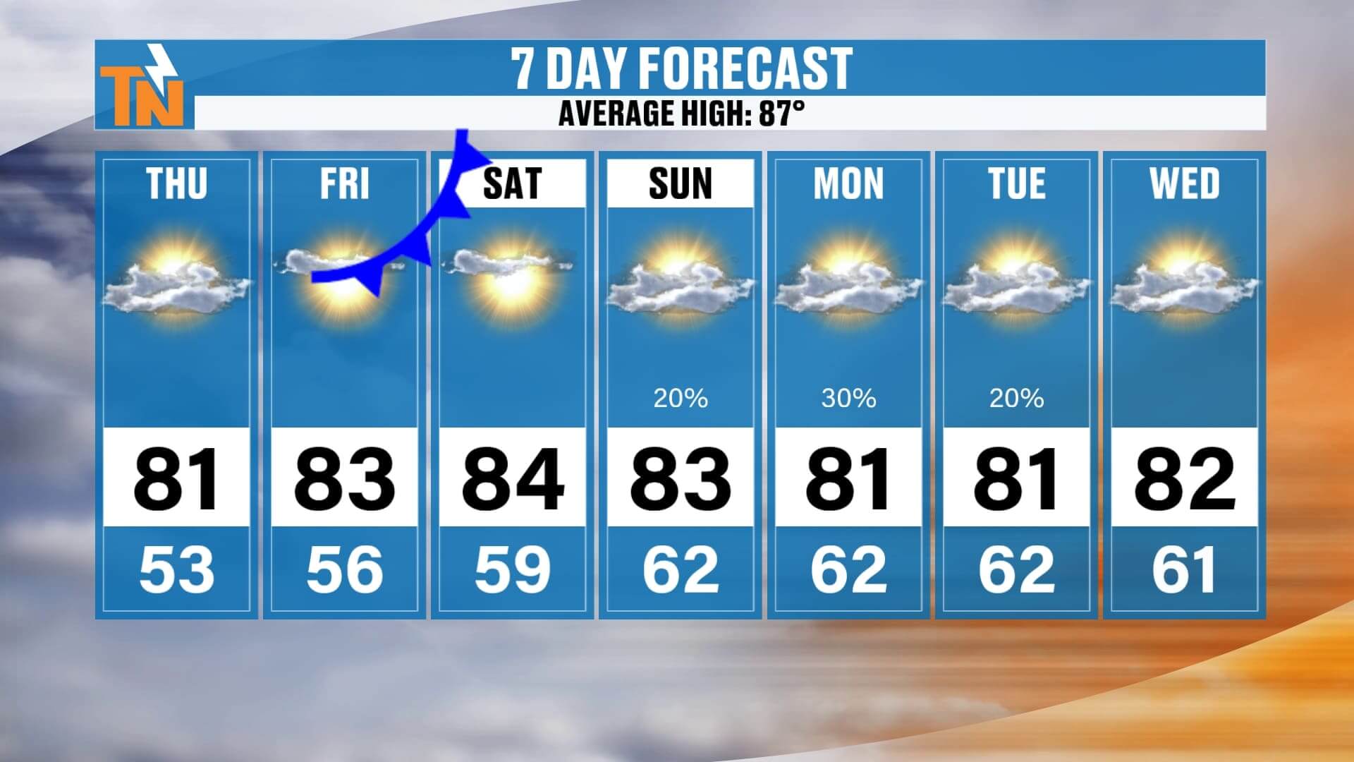
Afternoon: Highs climb into the low to mid-80s, still a touch below average for late August.
-
Evening: Temperatures ease back into the 70s by the evening commute—around 78° at 6 PM, 72° at 8 PM, and down to the upper 60s by 10 PM.
If you have outdoor plans tonight—whether it’s football practice, dinner on the patio, or a walk through the neighborhood—conditions will be just about perfect.
Looking Toward the Holiday Weekend: Subtle Changes Coming
While today and tomorrow look fantastic, we do have some changes setting up as we head into Labor Day weekend.Here’s the breakdown:
-
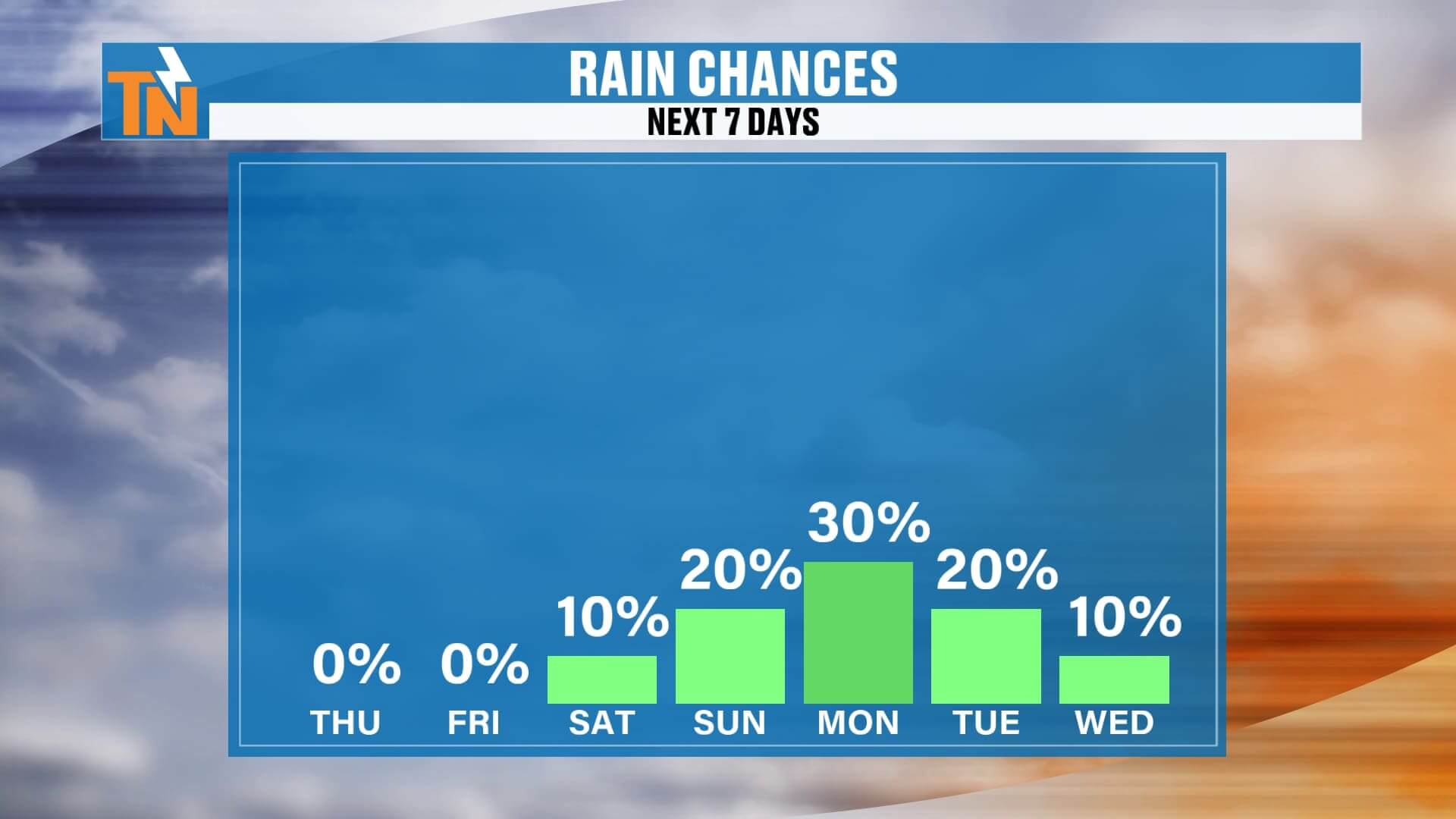
Friday–Saturday: A weak cold front will slide through, but it’s moisture-starved. Expect little more than a breeze and perhaps a few clouds. No measurable rainfall is expected. Saturday will be the warmest day of the week, with highs in the mid-80s.
-
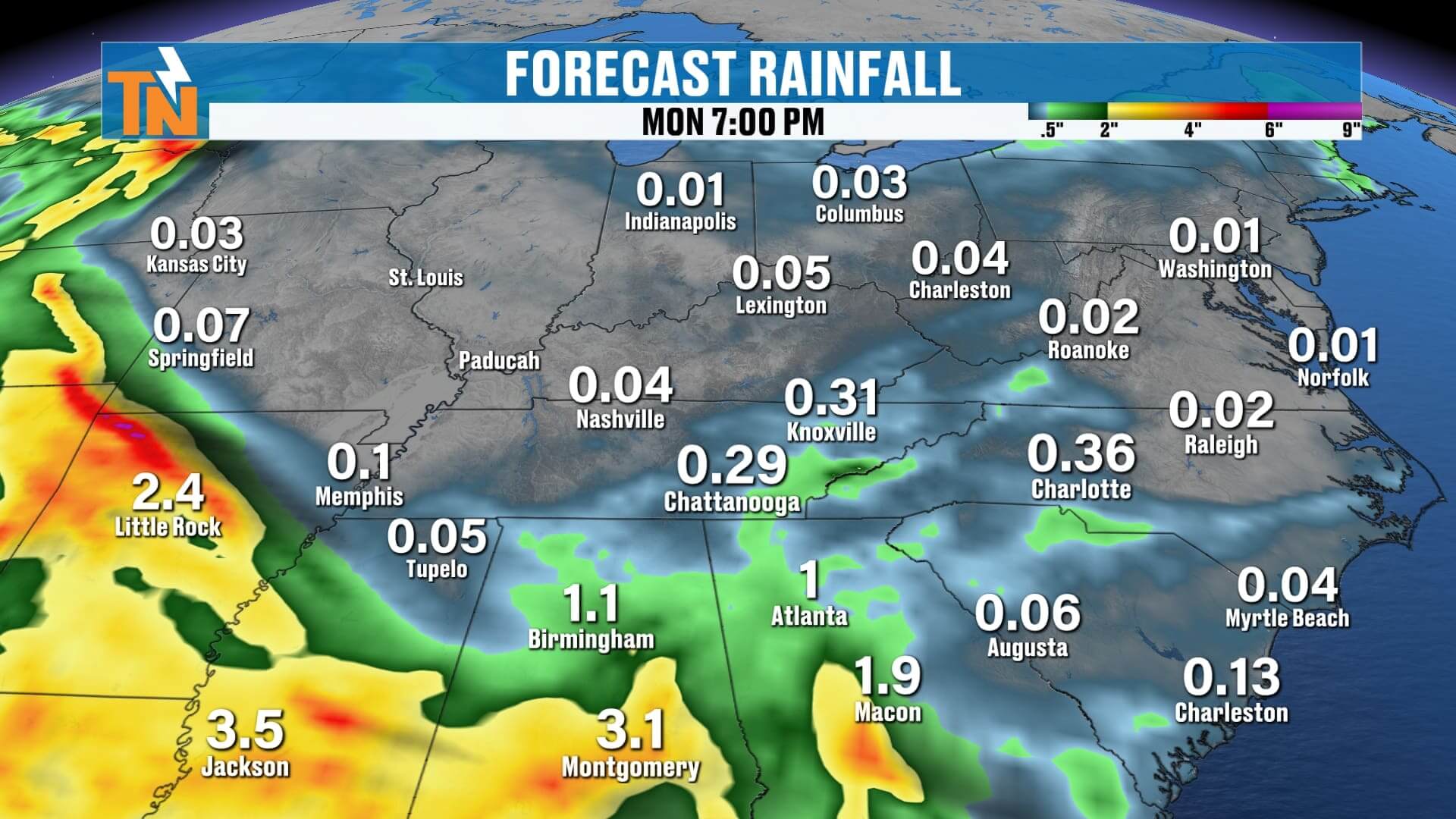
Sunday–Monday: A return flow from the south and southeast pumps more moisture into East Tennessee. Dew points climb, which means warmer, muggier mornings and the return of isolated showers or thunderstorms.Activity looks most likely Sunday afternoon through Monday evening, but nothing widespread or all-day.
-
Tuesday: A few lingering showers possible, but again, not a washout.
So if you’re camping in the Smokies, heading to the lakes, or firing up the grill this holiday weekend, conditions look good overall—just keep an eye out for scattered pop-up showers later in the weekend.
Extended Outlook: Another Taste of Fall
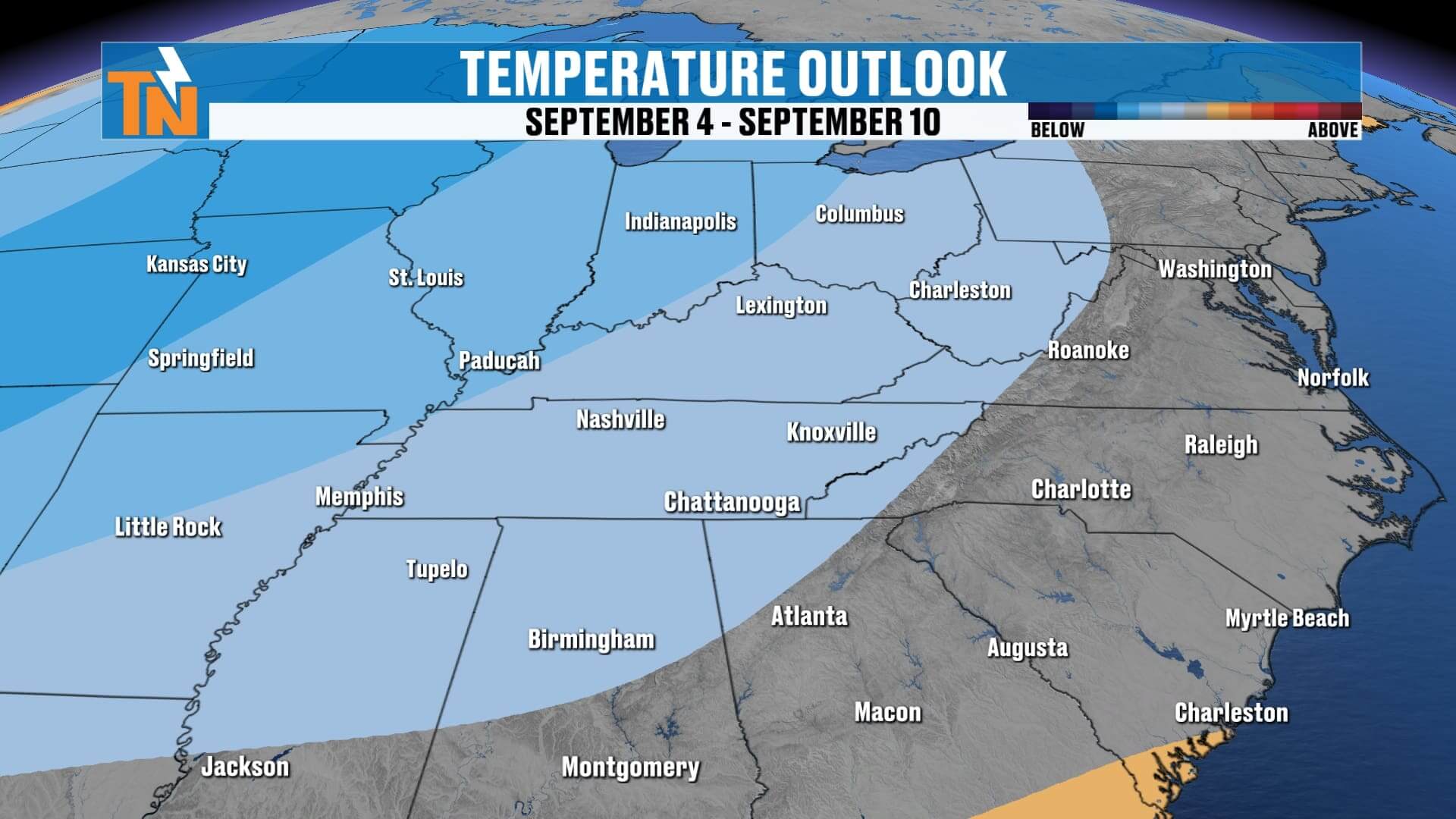
Looking just beyond the 7-day forecast, models are lining up on yet another trough of low pressure dropping into the eastern U.S. around the middle to end of next week. That would bring:
-
Another drop in temperatures—back into the 70s for highs
-
Lower dew points and less humidity
-
The return of that crisp, refreshing false fall feel across East Tennessee
So, while the weekend will feel a little warmer and stickier at times, we’re not done with those cooler, drier shots of air just yet.
Weather Headlines
-
️ Thursday: Mostly sunny, a few high thin clouds, no rain
-
️ Highs in the low to mid-80s, slightly warmer than earlier this week
-
Labor Day Weekend: Warmest day Saturday, then humidity and stray showers return Sunday–Monday
-
️ No washouts—rain chances remain low and scattered
-
Next trough mid to late next week brings another cool-down
ABOVE AND BEYOND THE 7 DAY FORECAST
Final Word
We’re wrapping up August on a great note: sunny skies, comfortable afternoons, and no major storms on the horizon. The Labor Day weekend forecast looks favorable overall, with just a few pop-up rain chances later Sunday into Monday. And for those of you enjoying these crisp mornings, good news—another taste of fall-like air is set to arrive behind next week’s trough.
Stay connected with the eastTNweather app for interactive radar, live lightning alerts, and daily updates across Knoxville, the Plateau, and the Smoky Mountains. Free to download—your local weather coverage is always at your fingertips.
Enjoy this beautiful Thursday, East Tennessee. I’ll see you back here with more updates as we track the holiday weekend!