
Good morning, East Tennessee!
Happy Thursday. I’m meteorologist Mike Witcher from the East Tennessee Weather Center, and we’re waking up to a stormy start across the region. Showers and thunderstorms are already rolling through the mountain counties and parts of the southern valley, bringing downpours and rumbles of thunder. This is all tied to a cold front sliding into the area today—a front that brings not just rain, but also the chance for isolated strong to severe storms.
Storm Setup This Morning
-
Radar Check: Rain and storms are moving from southwest to northeast early this morning, with the heaviest activity over the mountains and into parts of Upper East Tennessee.
-
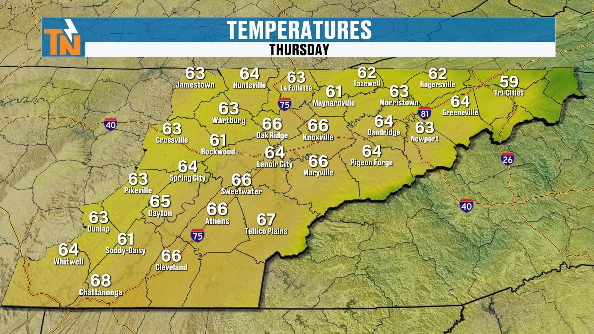
Temperatures: Starting mild and muggy, in the 60s across the Valley.
-
Atmosphere: Loaded with moisture, primed for additional showers and storms later today.
This is just the beginning of a busy 48 hours of weather across Knoxville, the Smokies, and the Plateau.
Severe Weather Risk Today
The Storm Prediction Center has placed all of East Tennessee under a Level 1 risk for severe storms.
-
Main Threat: Damaging wind gusts with stronger thunderstorms.
-
Secondary Threat: Localized flooding, especially north of I-40 along the Tennessee–Kentucky border, where soils are saturated from earlier rain.
While this is not a high-end severe weather setup, it’s one to watch carefully—especially if you’ll be on the roads or outdoors later today.
Futurecast: Timing Out Today’s Storms
-
Morning (Now–Noon): First wave of storms pushes through. Most of the region gets a break after this initial batch exits.
-
Afternoon (Noon–3 PM): Cold front approaches, triggering new rounds of showers and thunderstorms.
-
Evening (3–7 PM): Storm coverage increases. Most of East Tennessee will see at least some rain before the day ends. Strong storms will be scattered but possible.
-
Tonight: Lingering showers and rumbles of thunder with cooler air filtering in.
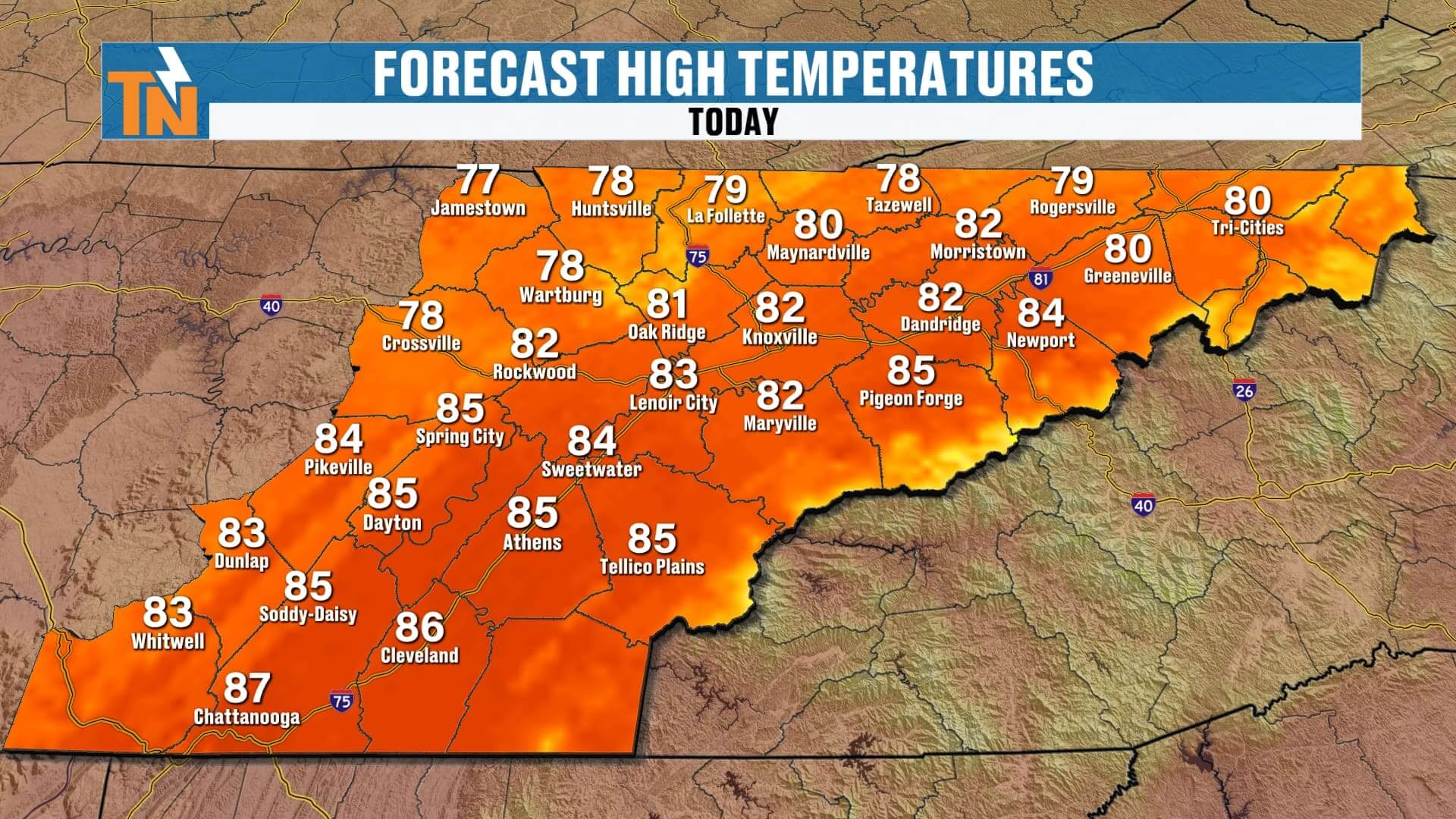
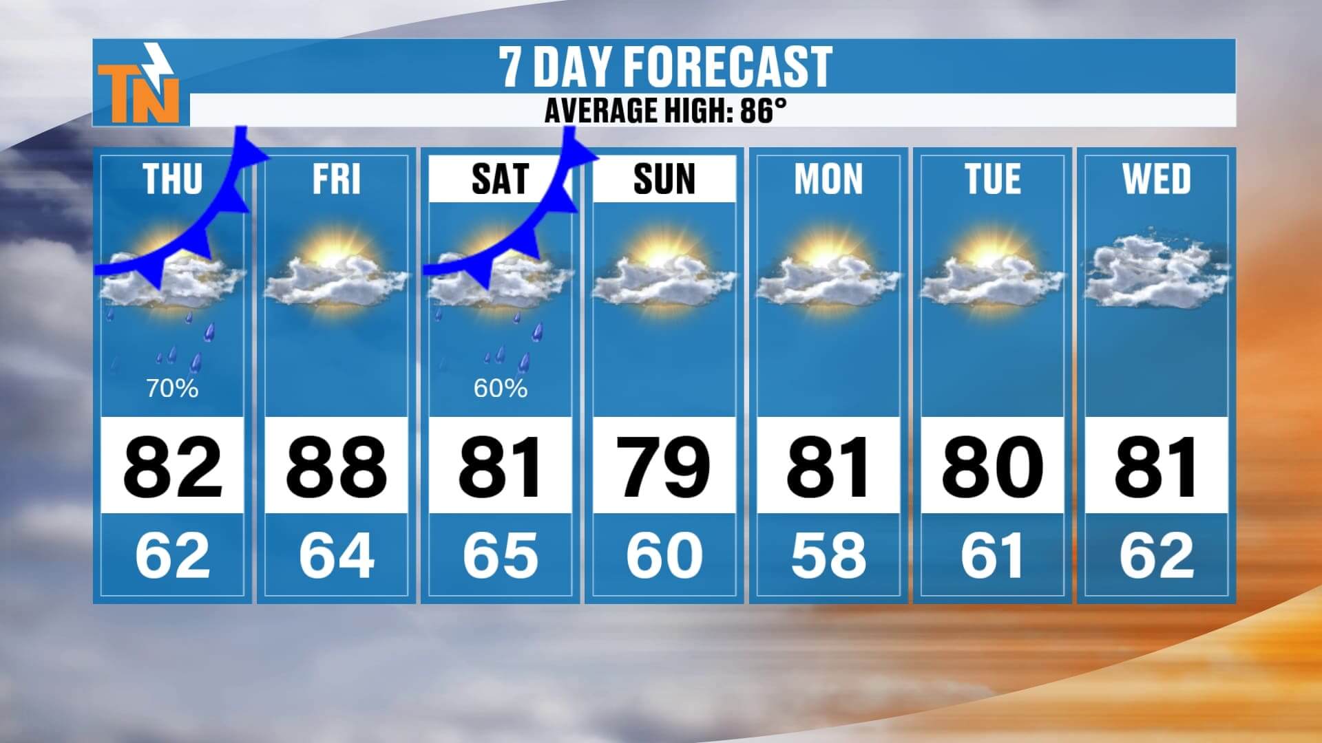
Highs today: 70s and low 80s, below seasonal averages.
Evening temps: Around 77° at 6 PM, dipping to 69° by 10 PM.


Friday: Dry and Hot Ahead of Our Next Cold Front
Behind today’s front, Friday turns out beautiful but warmer.
-
Morning: Lows in the 60s, mild and quiet.
-
Afternoon: Sunshine with highs climbing into the upper 80s to near 90°. That makes Friday the warmest day of the 7-day forecast.
-
Evening: Dry and pleasant, perfect for high school football or outdoor plans.
But the warmth doesn’t last long—Cold Front #2 arrives Saturday.
Saturday: Showers Threat UT Football Game
All eyes are on Neyland Stadium for Saturday’s UT Football home opener against ETSU (kickoff 3:30 PM). Unfortunately, another cold front could play spoiler.
-
Morning: A few lingering showers possible around 7 AM.
-
Afternoon: By 2 PM, models show a line of showers and storms pushing into East Tennessee.
-
Kickoff (3:30 PM): Scattered showers possible during tailgating and into the game itself.
-
Evening: Showers taper later in the night as the front clears.
If you’re tailgating or heading to Neyland, pack the poncho—rain chances are high enough that most Vol fans will likely see showers at some point Saturday.
Sunday Into Next Week: Gorgeous Fall-Like Weather
Behind Saturday’s front, we get rewarded with another stretch of refreshing air:
-
Sunday–Wednesday: Sunshine dominates.
-
Highs: Upper 70s to low 80s.
-
Lows: Comfortable 50s.
-
Dew Points: Dropping back into the 50s for that crisp, dry, false fall feel.
This will be one of the best stretches of weather we’ve seen in weeks—great for hiking in the Smokies, outdoor events, or just enjoying those cooler mornings.
7-Day Forecast at a Glance
-
Thursday: Storms, some strong, highs 70s–80s
-
Friday: Dry, sunny, hot—highs upper 80s to near 90°
-
Saturday: Cold Front #2, scattered showers/storms, UT game could be wet
-
Sunday: Sunshine, cooler, crisp morning in the 50s
-
Monday–Wednesday: Dry, mild, highs in the upper 70s, lows in the 50s
Weather Headlines
-
⛈️ Thursday: Storms today, Level 1 severe risk, damaging winds possible
-
️ Friday: Warmest day, highs near 90°
-
Saturday UT Football: Cold front brings scattered showers during game time
-
️ Sunday–Wednesday: Dry, crisp, fall-like air returns


ABOVE AND BEYOND THE 7 DAY FORECAST


Final Word
Today is a stormy one across East Tennessee. Expect morning showers, then another round of storms this afternoon and evening as Cold Front #1 moves through. A second cold front arrives Saturday, and that one could bring showers right during the Vols’ first home game at Neyland Stadium. The good news? Sunday through midweek looks fantastic with sunshine, cooler temps, and crisp mornings.
Track storms on the go with the eastTNweather app. Turn on notifications and GPS services for instant National Weather Service alerts, and use the interactive radar to follow showers around Knoxville, the Plateau, and the Smoky Mountains.
Have a great Thursday, East Tennessee—and stay weather aware!