
Recent Rainfall and Ongoing Drought Conditions in East Tennessee
Over the past 24 hours, we managed to squeeze out some beneficial rainfall across portions of the Tennessee Valley. While totals were generally light, the moisture was welcome. Moderate drought conditions have been slowly expanding across the region, especially in areas that have missed out on heavier rain events over the past several weeks.
Even small rainfall amounts can temporarily ease fire danger and improve soil moisture. However, longer-term relief will require more widespread and sustained rain events — something we were eyeing for next week. Recent forecast model updates, though, suggest that the heaviest rainfall may set up just north of the Tennessee-Kentucky border.
That means we’ll need to closely monitor the position of that boundary in the coming days.

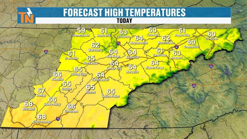
Friday Forecast: Sunshine and Comfortable Temperatures
This morning, temperatures are running slightly cooler compared to yesterday, but overall it’s a comfortable start. We’re seeing readings in the 30s and 40s across much of East Tennessee, with some 50s in the southern valley.
As we head into the afternoon, sunshine dominates the forecast. High pressure is firmly in control, giving us clear skies, light winds, and afternoon highs climbing into the 60s. It’s a fantastic late-winter, early-spring setup.
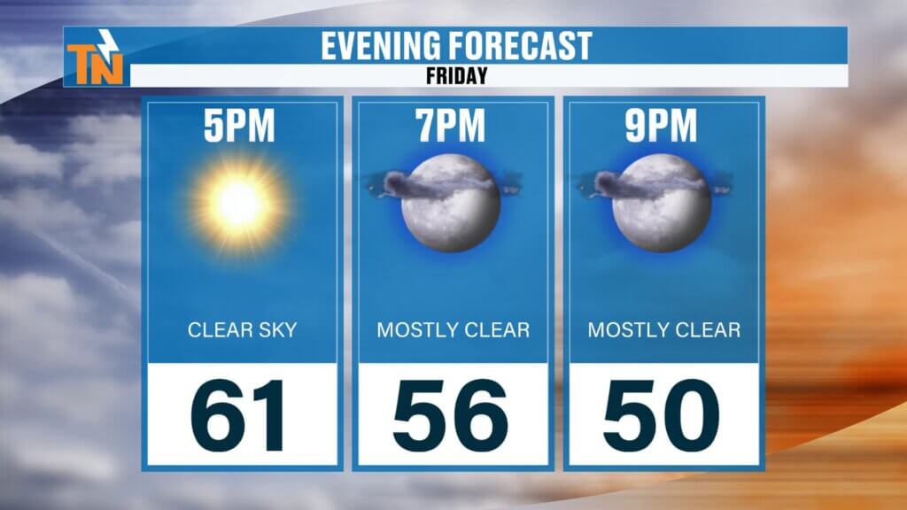
If you have evening plans — date night, dinner reservations, outdoor activities — expect temperatures to fall from the low 60s around 5 PM into the lower 50s by 9 PM. A light jacket should do the trick.
Weekend Outlook: Spring-Like Warmth with Increasing Clouds
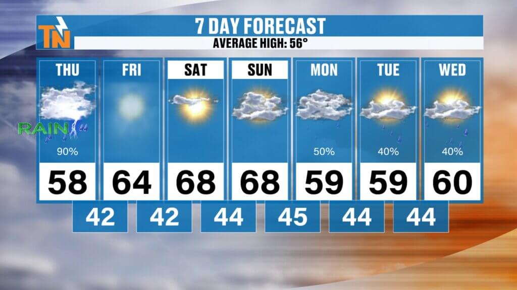
Saturday looks like one of the best days of the forecast period.
Expect abundant sunshine, light winds, and afternoon highs in the upper 60s to near 70 degrees. It will feel much more like mid-spring than late winter. If you’ve been waiting to get outside, tackle yard work, hike, or enjoy time at the lake, Saturday is your day.
As we head into Saturday night and Sunday, things begin to shift.
A weak cold front and upper-level disturbance will approach the region. This front does not appear particularly strong, and it may not fully push through East Tennessee. However, it will bring increasing cloud cover throughout the day Sunday.
Sunday morning should start partly cloudy. Rain chances remain low early in the day, but we can’t rule out a stray light shower, especially as we move into the afternoon and evening hours. Overall, Sunday looks more cloudy than rainy.
🌦️ Late Sunday into Early Next Week: Active Weather Returns
This is where the forecast gets interesting.
Earlier projections showed a stronger boundary setting up farther south, potentially bringing widespread, drought-busting rainfall across much of East Tennessee next week. However, the latest model guidance suggests that the heavier rain axis may shift northward.
If that trend holds:
- Heavier rainfall would focus along the Tennessee-Kentucky border and farther north.
- East Tennessee would see more scattered showers with lighter totals.
- Rain chances would remain in the 20 to 40 percent range Sunday through Thursday.
That boundary position is critical. A small northward or southward shift could dramatically change rainfall totals locally.
If it shifts south, we’re looking at a much wetter and potentially cooler week. If it stays north, we remain relatively mild and somewhat drier.
For now, we’ll maintain scattered rain chances with temperatures cooling slightly into the upper 50s Monday before rebounding into the 60s — and possibly even low 70s — by next Thursday.
Temperature Trend: Warmer Pattern Continues
Here’s the broader temperature story:
- Friday: Sunshine and 60s
- Saturday: Upper 60s to low 70s
- Sunday: Upper 60s with increasing clouds
- Monday: Cooler, upper 50s
- Mid-to-late next week: Back into the 60s and possibly low 70s
Keep in mind, if rain coverage increases next week, temperatures may trend slightly cooler than currently projected.
Meteorological Spring Begins Sunday
One final note: Sunday marks the first day of meteorological spring. While astronomical spring arrives later in March, meteorological spring runs from March 1 through May 31 and is based on annual temperature cycles.
And judging by this forecast, spring is definitely trying to make an early appearance across East Tennessee.
Final Thoughts
To recap:
- Sunshine and mild temperatures today.
- Beautiful, spring-like weather Saturday.
- Increasing clouds Sunday with low rain chances.
- Uncertainty next week depending on where the rain boundary sets up.
- Temperatures generally above average.
Be sure to check back daily as we fine-tune next week’s rainfall potential. A small shift in the storm track could mean the difference between scattered showers and widespread soaking rain.
Have a great Friday and enjoy the early taste of spring.