
Good morning and Happy Sunday.
Thanks for checking in with your East Tennessee morning weather update. We have major weather changes on the way today, tonight, and into Monday as a powerful storm system approaches the Tennessee Valley.
We’ll enjoy warm spring-like weather today, but a strong cold front will arrive overnight bringing the risk for severe thunderstorms, followed by falling temperatures and even a few snow showers on Monday as colder air surges into the region.
Let’s walk through what to expect.
Warm and Windy Sunday Across East Tennessee
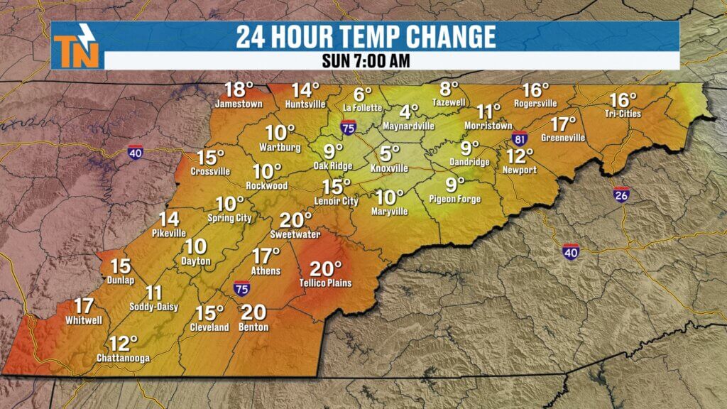
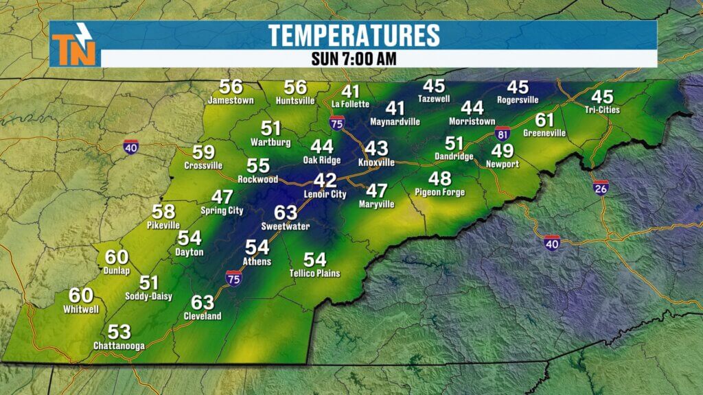
The day is starting off mild across the region, with temperatures running 10 to 20 degrees warmer than yesterday morning in many areas.
Current morning temperatures include:
- Upper East Tennessee: 40s
- Central and southern valley: 50s
- Some locations approaching 60 degrees
With warm air surging north ahead of the approaching storm system, temperatures will climb quickly.
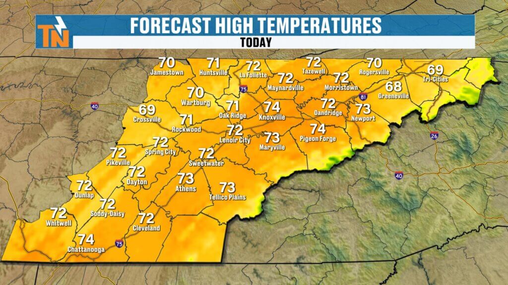
Sunday Forecast
- Afternoon highs near 74 degrees
- Breezy to windy conditions
- Increasing clouds later in the day
For most of the daylight hours, conditions will remain dry and very mild, making it a great day for outdoor plans.
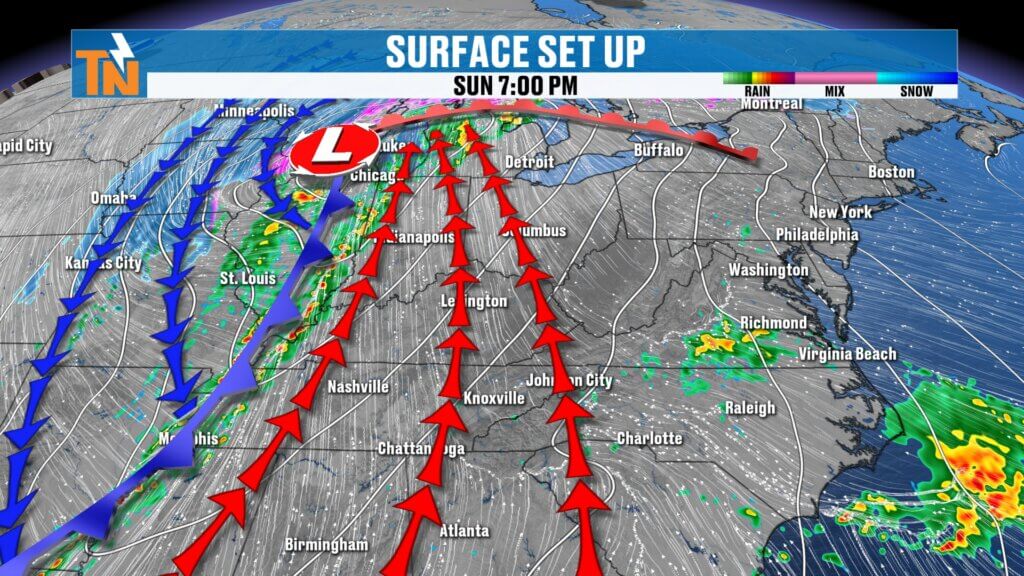
Strong Storm System Moving Toward the Tennessee Valley
A deep upper-level trough moving across the central United States will drive a powerful cold front toward the Southeast.
This system has all the ingredients needed to produce severe weather across the region, including:
- Increasing moisture
- Strong atmospheric energy
- A powerful low-level jet stream
- Increasing instability
Warm, moist air ahead of the front will push dew points into the 50s and low 60s, creating the fuel needed for thunderstorms.
Behind the front, much colder and drier air will quickly rush into the region.
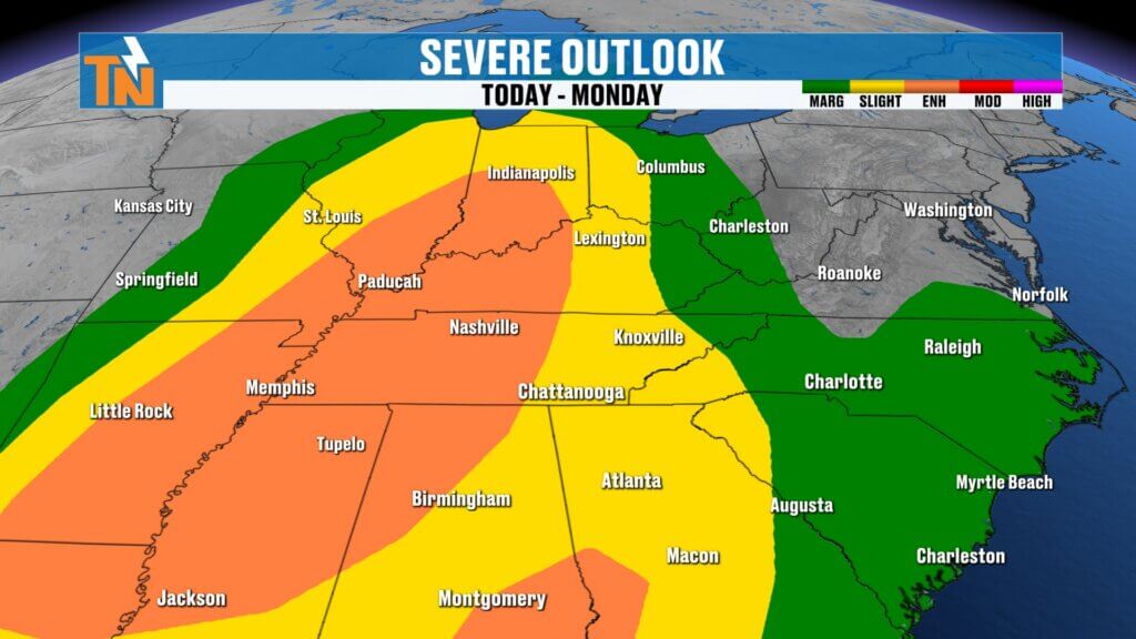
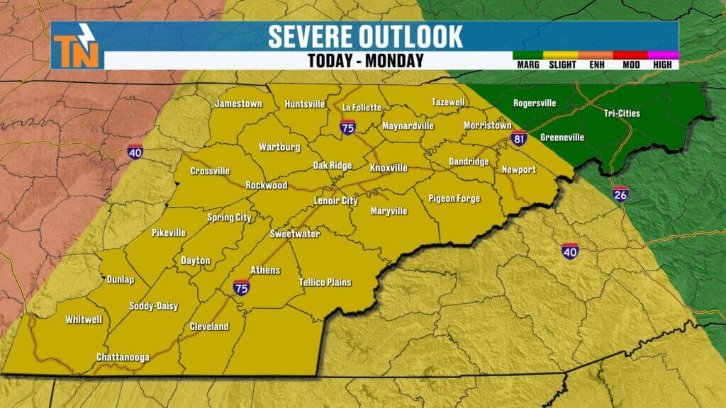
Severe Weather Risk Sunday Night
The Storm Prediction Center has highlighted a risk for severe storms across much of the Tennessee Valley tonight.
Severe Weather Risk Levels
- Level 2 risk for the Cumberland Plateau and western valley
- Level 1 risk across the remainder of East Tennessee
- Level 3 risk just west of the region near western Tennessee and Kentucky
The greatest severe weather potential will remain just west of East Tennessee, but the storm line will still bring strong storms into our area overnight.
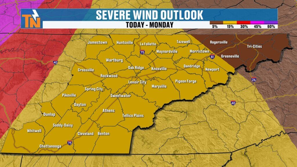
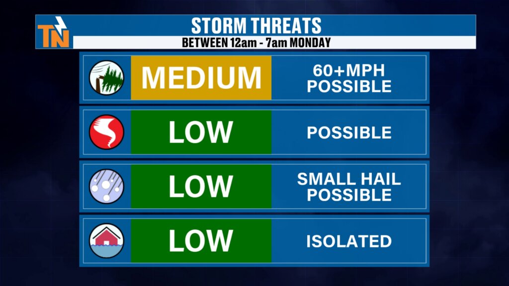
Main Severe Weather Threats
The primary threat with tonight’s storms will be damaging wind gusts.
Potential Storm Hazards
- Damaging winds over 60 mph
- Frequent lightning
- Heavy rainfall
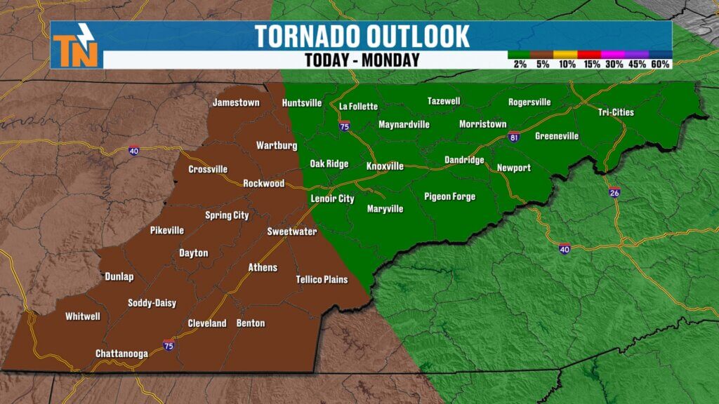
Secondary threats include:
- Brief spin-up tornadoes (low probability)
- Isolated flooding
- Small hail (very limited potential)
Tornado potential remains low but not zero, especially along the leading edge of the storm line.fuel for thunderstorm development.
Timeline for Storms Overnight
Most of the severe weather will occur after midnight as the cold front pushes into East Tennessee.
Expected Timing
Sunday Evening
- Warm, breezy, and mostly dry
Midnight – 2 AM
- Storms reach the Cumberland Plateau
2 – 4 AM
- Storms move into the Tennessee Valley
4 – 7 AM Monday
- Heavy rain and weakening storms continue across the region
By sunrise Monday, the severe weather threat should gradually diminish, leaving wet roads for the morning commute.
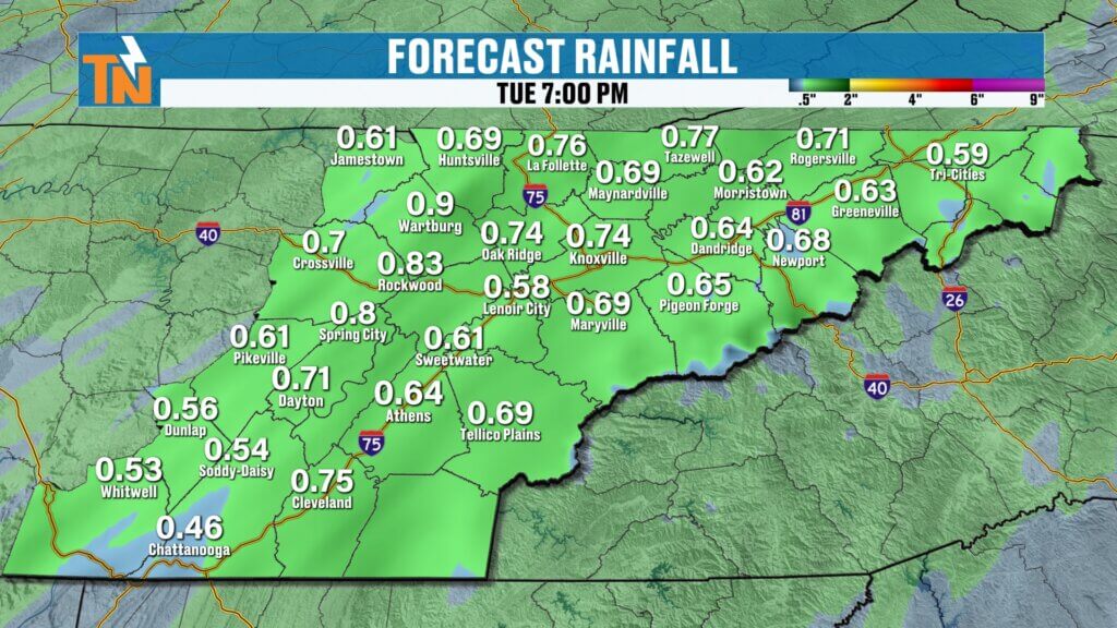
Heavy Rain Expected
Rainfall totals with this system will range between:
- 0.5 to 0.75 inches across most of East Tennessee
This rainfall will be beneficial but should not lead to widespread flooding.
Localized flooding could still occur briefly where heavier storms pass.
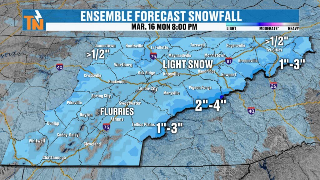
Snow Showers Possible Monday
As the cold front exits the region, cold air will rapidly move into East Tennessee, causing temperatures to fall throughout the day Monday.
As colder air catches up to the remaining moisture, rain may transition to snow showers, especially in higher elevations.
Expected Snowfall
- Valley locations: brief snowflakes possible
- Cumberland Plateau: light dusting possible
- Higher elevations of the Smokies: 2 to 4 inches possible
Because the ground remains warm, roads should stay mostly wet, with snow mainly sticking to grassy areas and rooftops.t and slow-moving with leftover rain.
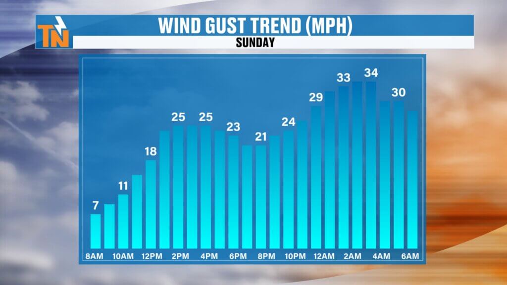
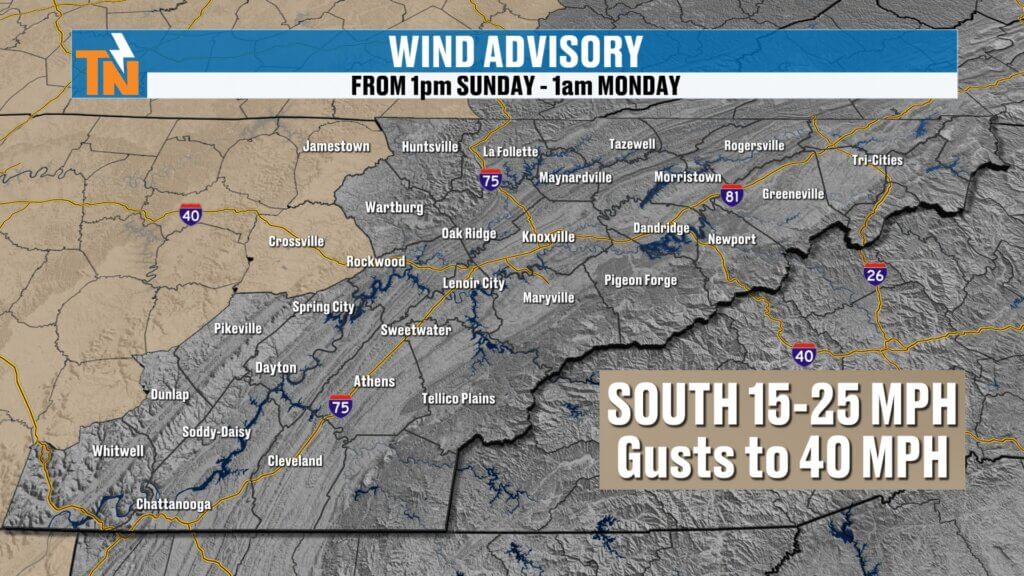
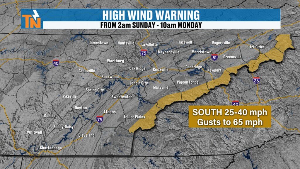
Strong Winds Expected
Winds will increase significantly ahead of and behind the cold front.
Wind Headlines
- Wind Advisory for the Cumberland Plateau
- High Wind Warning for the Smoky Mountains
Expected wind gusts include:
- Valley locations: 30 to 40 mph
- Mountains: 65+ mph possible
These strong winds are being driven by an extremely powerful low-level jet stream around 5,000 feet above the surface.
Much Colder Air Early Next Week
Temperatures will fall sharply Monday as colder air pours into the region.
Monday Temperature Trend
- Morning temperatures near 43 degrees
- Afternoon temperatures falling into the 30s
By Tuesday and Wednesday mornings, temperatures will drop into the low to mid 20s.
Warmer Weather Returns Later Next Week
The cold snap will not last long.
Temperatures will gradually rebound later in the week, with highs returning to the 40s and 50s, followed by even warmer conditions beyond the 7-day forecast.
Long-range outlooks suggest above-average temperatures and drier conditions returning to the region.
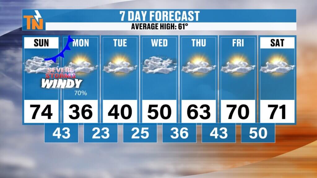
East Tennessee 7-Day Weather Outlook
- Sunday: Warm and breezy, high near 74°
- Sunday Night: Strong storms overnight
- Monday: Rain early, falling temperatures with snow showers possible
- Tuesday: Cold with morning lows in the 20s
- Wednesday: Chilly but dry
- Thursday: Temperatures moderating
- Friday: Warmer conditions return
Final Thoughts
Enjoy the warm weather today, but stay weather aware tonight. A strong storm system will move through late Sunday night bringing the risk for damaging winds and heavy rain, followed by a quick return to winter-like conditions Monday.
Make sure you have a way to receive weather alerts overnight.
The East Tennessee Weather App is the best way to stay informed with watches, warnings, lightning alerts, and interactive radar wherever you are.
Have a great Sunday and check back in later tonight for updates as the storms approach.