
Good morning and Happy
Friday. A big day ahead with warm temperatures, breezy conditions, and a cold front bringing some light rain later today. If you’ve got plans—especially for tonight’s big game—here’s what to expect.
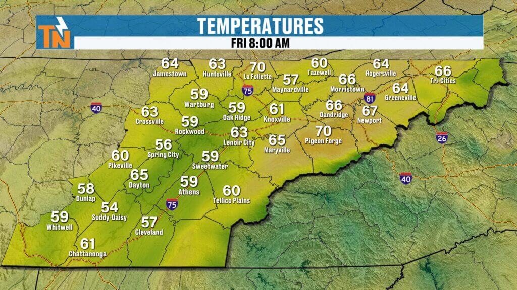
Warm Start with Spring-Like Feel
We’re kicking off the day unusually warm for this time of year.
- Morning temps in the 50s, 60s, even a few 70s
- Already near what we’d typically see for afternoon highs
- Breezy south to southwest winds setting the tone
This warm start is thanks to a strong push of air ahead of an approaching cold front.
Clouds Increase Ahead of a Cold Front
The day begins quiet, but changes are on the way.
- Mostly clear early this morning
- Clouds increase through the late morning and lunchtime
- Dry through midday
By the afternoon, that cold front gets closer and begins to impact the area.
Afternoon and Evening: Light Rain Moves In
Rain chances increase later today, but this is not a major event.
- Scattered light rain developing during the afternoon
- Better coverage into the evening hours
- More nuisance rain than anything heavy
If you’ve got evening plans:
- Around 72° at 5 PM
- Falling to the upper 50s by 9 PM
- Temperatures drop quickly after sunset
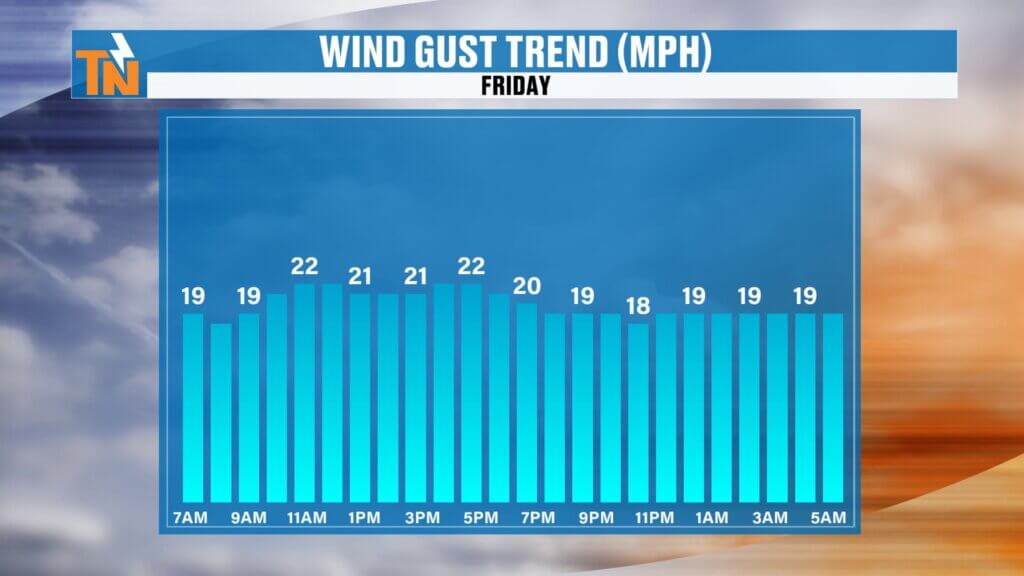
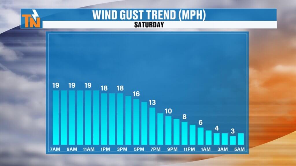
Breezy Conditions Continue
Wind will be a factor once again today.
Breezy conditions continue into early Saturday
Gusts 20–25 mph out of the south and southwest
Winds shift to the north behind the front tonight
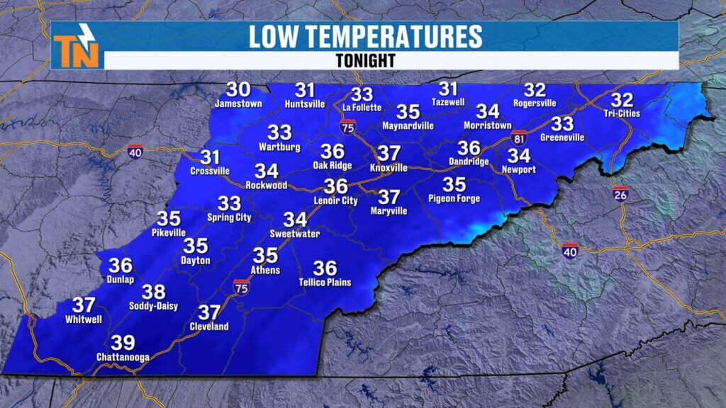
Cooler Air Arrives Overnight
Once the cold front passes, big changes settle in.
- Rain tapers off after midnight
- Northerly winds bring in cooler, drier air
- Temperatures fall quickly overnight
Saturday morning will feel very different compared to today.
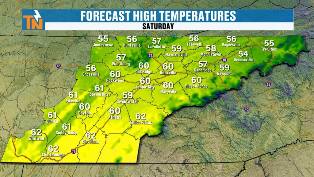
Chilly Saturday Morning with Freeze Concerns Nearby
Get ready for a much cooler start to the weekend.
- Low 30s near the Tennessee/Kentucky border
- Freeze Watch in effect for parts of Kentucky
- Coldest air focused north, but still chilly across East Tennessee
Highs Saturday only reach the 50s to low 60s.
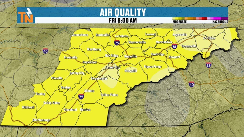
Improving Air Quality This Weekend
Some good news with the front moving through.
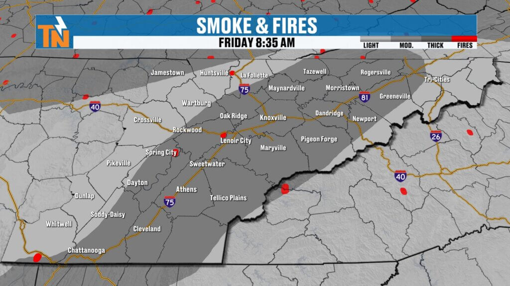
Much cleaner, crisper air settles in
Smoke and haze clear out later today into tonight
Air quality improves heading into the weekend
Weekend Outlook: Cooler but Pleasant
Saturday and Sunday will feel much more seasonable.
- Highs in the low to mid 60s
- Cooler mornings with light winds
- Low humidity leading to elevated fire danger
Dry conditions stick around through the weekend.
Looking Ahead: Warming Trend Returns
After the brief cooldown, warmer weather quickly returns.
- Back into the 70s Monday and Tuesday
- Possibly near 80 by midweek
- Limited rain chances until late next week
There are early signs of a stronger system around next weekend that could bring more meaningful rainfall.
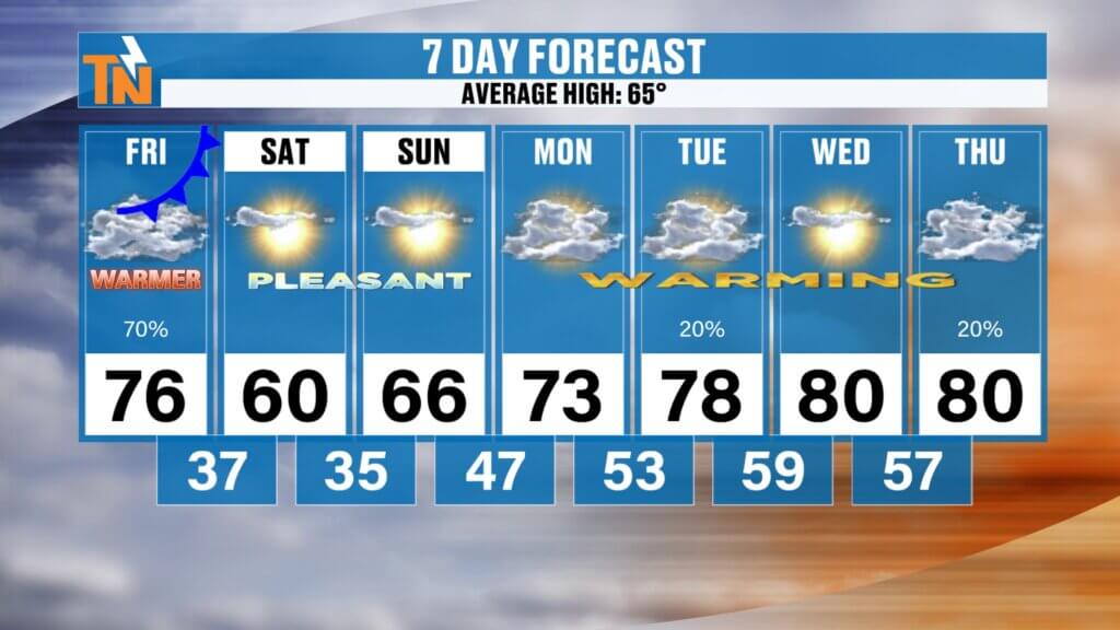
7-Day Snapshot
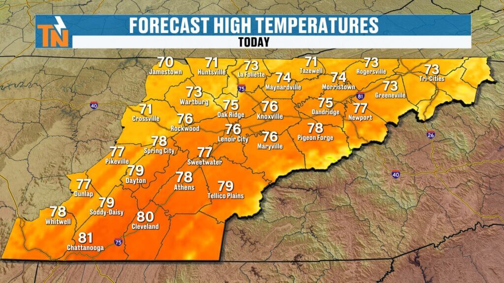
- Friday: Warm, breezy, light rain late (mid 70s)
- Saturday: Cooler, sunny (50s to low 60s)
- Sunday: Pleasant and mild (low to mid 60s)
- Monday–Tuesday: Warmer, back to the 70s
- Wednesday–Thursday: Near 80 possible
Final Thoughts
Enjoy the warm weather today, but keep the umbrella handy for some light rain later on. A noticeable cooldown arrives tonight, setting up a crisp and pleasant weekend across East Tennessee.
Have a great Friday and enjoy the game tonight!

Community Event Spotlight
Next Saturday, come out and join us at Timber Creek Landscape Supply in Powell (off Emery Road) from 10 AM to 2 PM.
- Meet and greet with me
- TK’s Gourmet Food Wagon
- Tiki’s Shaved Ice
- Spend $60 or more and get a free lunch
We’ll have the East Tennessee Weather tent set up—come hang out and kick off spring with us.