
Good morning and happy Tuesday, East Tennessee!
Thanks for checking in, and I hope you have a great day.
Yesterday turned into another typical July afternoon across the Tennessee Valley. Officially, McGhee Tyson Airport reached 91°, but didn’t pick up much rainfall. Meanwhile, Crossville was the big winner, collecting more than 1.75 inches of rain from slow-moving thunderstorms.
That same setup remains in place today, meaning another round of scattered afternoon showers and thunderstorms is expected.
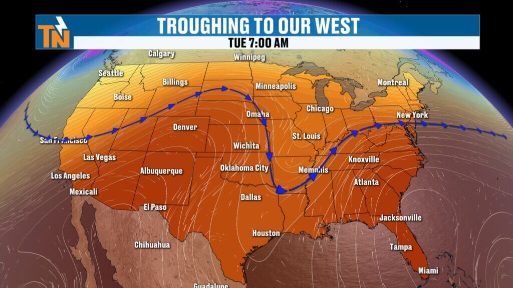
Upper-Level Trough Keeps the Storm Pattern Going
The overall weather pattern hasn’t changed much.
A broad upper-level trough remains parked just west of the Tennessee Valley. Within that trough, small disturbances continue rotating around the larger circulation.
One of those disturbances will move through East Tennessee this afternoon before the entire trough gradually shifts east later Wednesday into Thursday.
Each disturbance provides just enough lift to combine with our summertime heat and humidity, allowing scattered thunderstorms to develop during the afternoon.
It’s a classic midsummer weather pattern.
No Organized Severe Weather Expected
The good news is we are not under a severe weather outlook today.
However, that doesn’t mean every storm will be harmless.
Some of the stronger thunderstorms could still produce:
- Wind gusts of 40–45 mph
- Small hail
- Frequent lightning
- Torrential rainfall
Don’t be surprised if the National Weather Service issues a few Special Weather Statements this afternoon for stronger storms.
Localized Flooding Still Possible
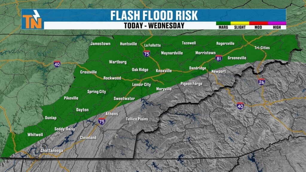
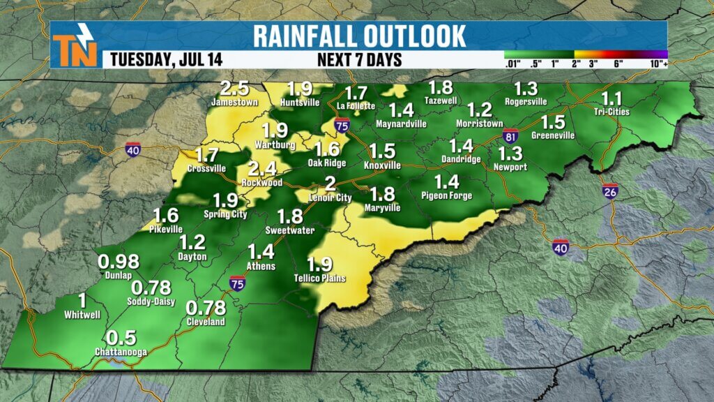
The Weather Prediction Center continues a Level 1 (Marginal) Risk for excessive rainfall across portions of East Tennessee.
Because storms will move very slowly today, any thunderstorm that develops may sit over one location for quite a while.
That means rainfall rates could become heavy enough to create:
- Ponding on roads
- Localized flooding
- Isolated flash flooding
Yesterday we saw several Flood Advisories issued, and a similar scenario is possible again today.
Today’s Timeline
The first half of the day remains fairly quiet.
By around lunchtime, the atmosphere should become unstable enough for showers and thunderstorms to begin developing.
Expected timing:
- Morning: Warm, humid, and mostly dry
- Noon: First storms begin developing
- 2 PM–5 PM: Greatest storm coverage
- Evening: Storms gradually weaken after sunset
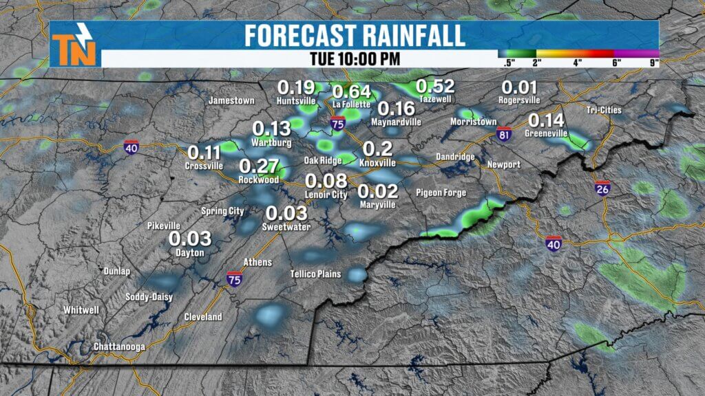
The greatest coverage today appears most likely across the northwestern portions of East Tennessee, including areas closer to the Cumberland Plateau.
Not everyone will receive rain, but those who do could see brief, heavy downpours.
Temperatures Today
Morning temperatures begin in the upper 60s and lower 70s, with areas of dense fog slowing travel in a few communities.
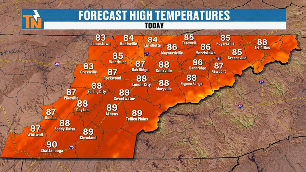
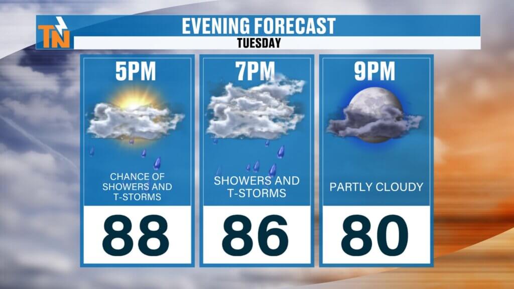
Afternoon highs climb back into the upper 80s and lower 90s.
Winds remain light throughout the day, another reason storms won’t move very quickly.
The good news?
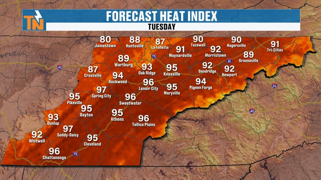
Heat index values won’t be nearly as extreme as last week.
Most locations should experience afternoon “feels-like” temperatures in the mid to upper 90s, which is much more manageable than the 105° heat indices we experienced just a few days ago.
By 7 PM, temperatures fall back into the middle 80s, another noticeable improvement from last week’s oppressive evenings.
Looking Ahead
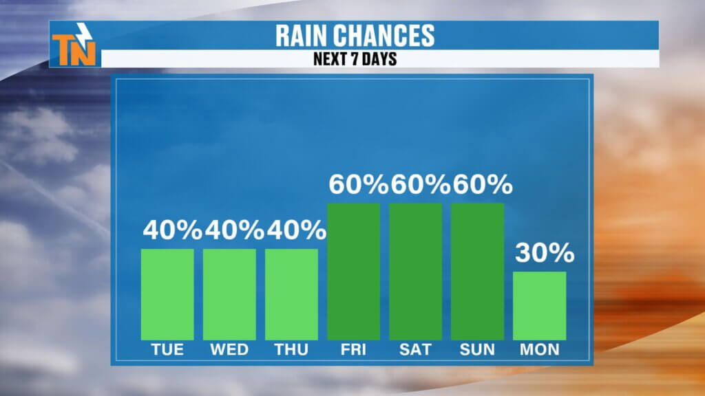
Rain chances stay elevated today before decreasing slightly Wednesday and Thursday.
Another cold front approaches as we head into the weekend, bringing another increase in afternoon showers and thunderstorms.
Early indications suggest drier weather may begin returning sometime next week as another ridge of high pressure starts rebuilding.
Rain Chances
- Tuesday: 40%
- Wednesday: 40%
- Thursday: 40%
- Friday: 60%
- Saturday: 60%
- Sunday: 60%
Remember, these aren’t all-day rain events.
Most days will feature dry mornings followed by scattered afternoon and evening storms.
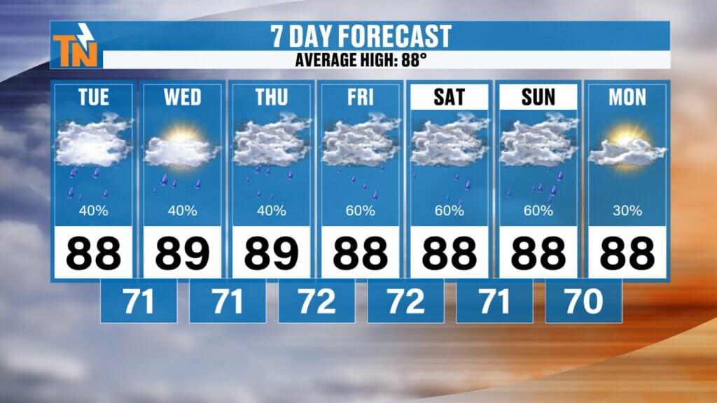
Seven-Day Forecast
- Tuesday: High 89°, scattered afternoon thunderstorms
- Wednesday: High 88°, isolated storms
- Thursday: High 88°, partly sunny
- Friday: High 89°, increasing storm chances
- Saturday: High 88°, scattered thunderstorms
- Sunday: High 88°, afternoon storms
- Monday: Warm and humid with fewer storms possible
Overnight lows remain in the lower 70s, and dew points stay in the lower to middle 70s, keeping humidity levels elevated throughout the week.
Bottom Line
Summer is settling into a very typical July pattern.
Expect:
- Warm mornings
- Hot, humid afternoons
- Scattered thunderstorms developing after lunchtime
- Slow-moving storms capable of heavy rainfall
Most communities won’t experience severe weather, but any thunderstorm can briefly produce gusty winds, lightning, and localized flooding.
As always, keep an eye on the radar throughout the afternoon using the East Tennessee Weather App. It’s still the best way to monitor storms in real time, receive weather alerts, and stay ahead of changing conditions.
Have a fantastic Tuesday, and if severe weather develops later today, you know exactly where I’ll be—front and center across all East Tennessee Weather platforms.