
Good morning, East Tennessee. Happy Monday and thanks for checking in for your detailed local forecast.
We are starting the day with a true winter chill across Knoxville, Farragut, Oak Ridge, Maryville, the Cumberland Plateau, and the Smoky Mountain region. A cold air mass has settled into the Tennessee Valley overnight, bringing clear skies, dry air, and temperatures that feel much colder than what we experienced just a few days ago.
Current Conditions and Cold Air in Place
Sunshine is dominating the radar this morning, but don’t let that fool you. This is a classic post-frontal air mass — dry, crisp, and cold. Morning temperatures are hovering in the 20s and 30s across much of East Tennessee, with some of the colder sheltered valleys dipping even lower. Wind speeds are light to moderate, but it doesn’t take much breeze to drive wind chills down several degrees.
This is the kind of setup where we see very low dew points. That dry air does a few things:
- It gives us those deep blue East Tennessee skies.
- It increases static electricity indoors.
- It dries out your skin quickly.
- It allows temperatures to fall fast after sunset.
If you’re heading out early, make sure you’ve got the winter coat handy. Even with sunshine, it’s a cold start.
Today’s Forecast: Sunny but Chilly Across East Tennessee
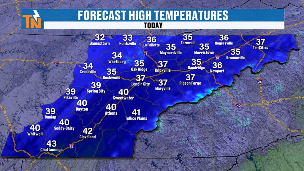
High pressure is building in behind the recent frontal passage. That ridge of high pressure will keep us mostly sunny through the afternoon. High temperatures today will top out in the upper 30s to near 40 degrees in Knoxville and surrounding communities. That’s below average for late February and a noticeable cooldown compared to the recent warmth.
Evening temperatures will drop quickly after sunset. With clear skies and calm winds overnight, radiational cooling will be efficient. Expect another cold night with lows falling back into the 20s across the Tennessee Valley and even colder in the higher elevations of the Smoky Mountains and Cumberland Plateau.
Clouds increase again this evening as the next disturbance approaches. Another wave of low pressure moves in overnight, bringing a fresh round of rain to East Tennessee.
This system will make for a soggy start to Saturday morning, similar to what we experienced yesterday — overcast skies, patchy fog, and damp conditions early.
Rainfall totals overnight into Saturday morning look light to moderate, generally between 0.10″ and 0.33″, but locally higher totals are possible in heavier showers.
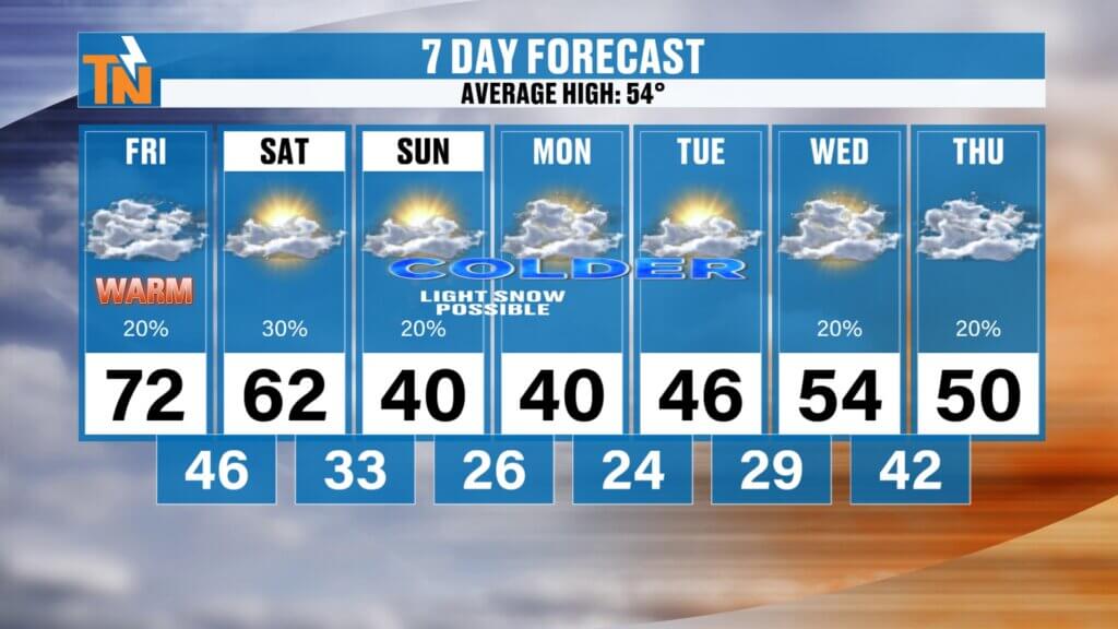
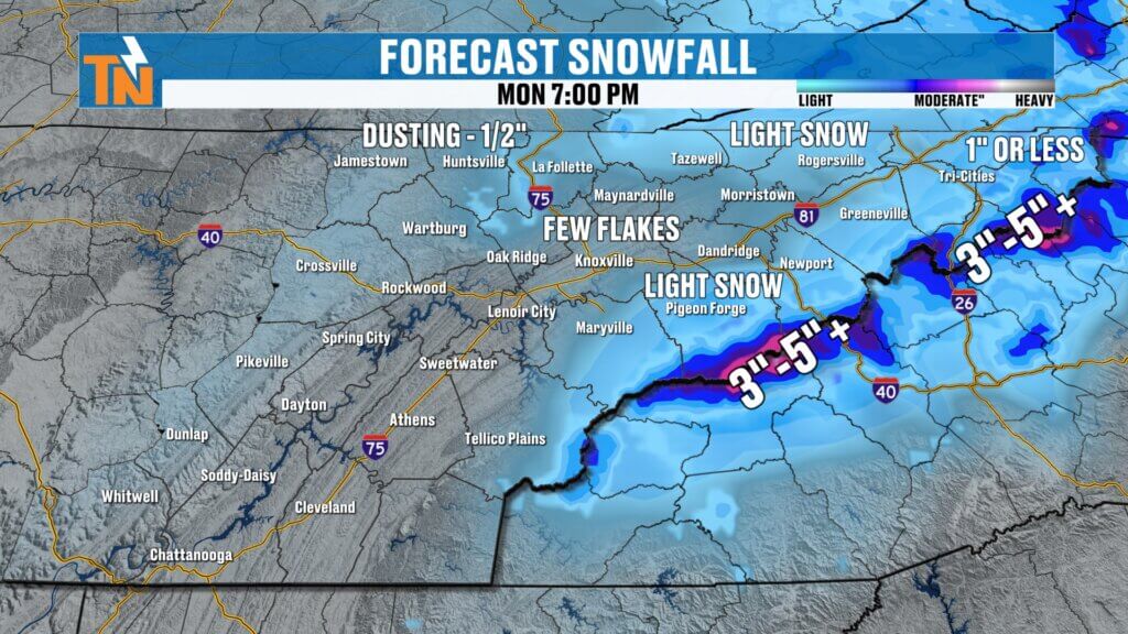
Monday Outlook: Cold but Quiet Weather
As we head into Monday, clouds increase at times, but the overall weather pattern remains quiet. Highs stay in the mid to upper 30s, and morning lows dip into the lower 20s in many spots. No major travel impacts are expected, but it will be cold for morning commutes.
This is a stable pattern — no significant storm systems nearby, just chilly air locked in place for another day.
Midweek Warming Trend for Knoxville and Surrounding Areas
Now here’s where things start to shift.
By Tuesday, we begin a gradual warming trend across East Tennessee. High temperatures climb back into the 40s with a mix of sun and clouds. The cold air mass begins to modify as winds shift more southerly.
Wednesday brings a more noticeable warm-up. Highs push into the 50s and even upper 50s in some communities. This is a classic late-winter transition pattern — brief cold shots followed by fast temperature rebounds.
If you’re planning outdoor activities midweek, Wednesday looks like one of the more pleasant days with milder temperatures and manageable winds.
Late-Week Rain and Increasing Wind
Attention then turns to our next weather system developing to our west. By Thursday, a strengthening low pressure system and associated cold front approach the Tennessee Valley.
We’re expecting:
- Increasing cloud cover.
- Gusty winds.
- Periods of rain.
- Potential for moderate rainfall totals.
Rain chances ramp up Thursday afternoon and continue into Friday. This does not appear to be a major severe weather setup at this time, but we will monitor for any changes as moisture increases and instability develops.
Extended Forecast: Active Pattern and Thunderstorm Potential
Looking beyond the immediate 5-day forecast, the overall weather pattern remains active across the Southeast United States. Another system may approach next weekend, bringing additional rain chances and possibly a few thunderstorms by Sunday.
Temperatures through the extended forecast trend above average. Highs could climb back into the 60s by next weekend, a sharp contrast from today’s winter chill.
This is a classic transitional East Tennessee weather pattern:
- Short-lived cold snap.
- Rapid warm-up.
- Followed by rain and another system.
- Then back to milder air.
East Tennessee Weather Summary
Today: Sunny, breezy, and cold. Highs near 40.
Tonight: Clear and cold. Lows in the 20s.
Monday: Cold with some clouds. Highs in the 30s.
Tuesday and Wednesday: Warming into the 40s and 50s.
Thursday: Increasing wind and periods of rain.
Next Weekend: Milder with additional rain and possible thunderstorms.
Be sure to stay updated with the latest East Tennessee weather alerts, radar updates, and extended forecast details. Weather conditions can change quickly this time of year, especially as we transition toward early spring.
Thanks for checking in. Have a great day, stay warm, and I’ll keep you posted as we track the next round of rain heading toward Knoxville, Farragut, and the surrounding Tennessee Valley communities