
Good morning and Happy Wednesday.
Thanks for checking in with your East Tennessee morning weather update. We’ve got quite the weather story unfolding this week, starting with a historic cold snap and ending with a big warmup just in time for the weekend.
Let’s start with what just happened and then walk through what’s ahead.
Historic Cold for March Across East Tennessee
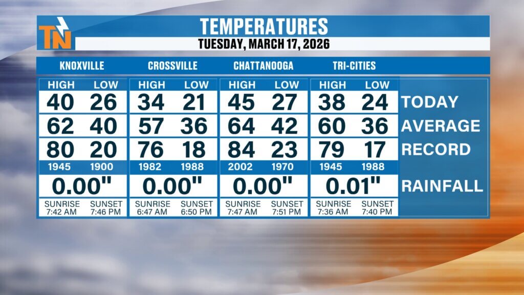
Yesterday was one for the record books.
Knoxville only reached a high of 40 degrees on St. Patrick’s Day, marking the coldest day in March in 126 years. While it wasn’t the coldest St. Patrick’s Day on record, it was the coldest daytime high recorded in the month of March in over a century.
Across the region:
- Crossville only reached 34 degrees
- Many areas stayed well below average all day long
This cold snap is a reminder of just how volatile spring weather can be across East Tennessee.
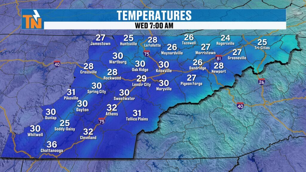
Chilly Start This Morning
We’re starting off another cold morning, though slightly warmer than yesterday.
Temperatures early this morning are in the:
- 20s across colder valley locations
- 30s across much of the region
Even with a slight improvement, it’s still a cold start and you’ll want the jackets as you head out the door.
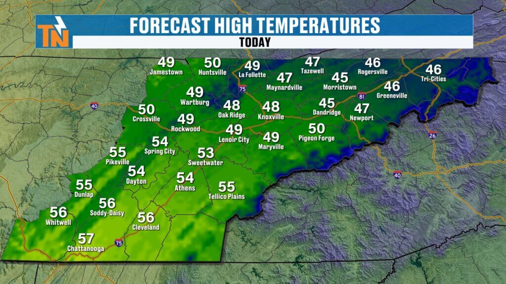
Cooler Than Average Temperatures Continue
Even though we’re beginning a gradual warming trend, temperatures today will still run well below average.
Forecast highs:
- Upper 40s to low 50s across East Tennessee
That’s roughly 10 to 15 degrees below normal for this time of year.
Weak Disturbance Brings Clouds Today
We’re tracking a weak disturbance moving through the region today as part of a northwesterly flow pattern in the atmosphere.
This setup will bring:
- Mostly cloudy skies
- A very small chance for sprinkles or flurries
However, the lower levels of the atmosphere remain very dry, meaning most of this system will be more bark than bite.
You may see:
- A brief sprinkle
- A passing flurry
But most locations will stay dry throughout the day.
Understanding the Weather Pattern
The overall weather pattern features:
- A strong ridge of high pressure across the southwestern United States bringing heat to that region
- A trough lingering across the eastern United States
- A northwesterly flow pattern delivering weak disturbances into East Tennessee
This pattern is keeping us:
- Cooler than average
- Mostly dry
- Occasionally cloudy
Meanwhile, out west, places like Arizona are seeing temperatures in the 90s under that ridge of high pressure.
Gradual Warmup Through the End of the Week
That ridge of high pressure will begin shifting eastward, allowing warmer air to move into the Tennessee Valley.
From Thursday through the weekend, we’ll see:
- Increasing sunshine
- Warmer afternoon temperatures
- Continued dry conditions
Beautiful Spring Weekend Ahead
By the time we get to the weekend, the warmup will be in full swing.
Forecast highs:
- Friday: low to mid 70s
- Saturday: mid 70s
- Sunday: upper 70s to near 80 degrees
It’s going to feel much more like spring, especially after the recent cold snap.
Next Cold Front Arrives Sunday Night into Monday
While the weekend looks great, our next weather system will arrive late Sunday into early Monday.
This system will bring:
- Increasing clouds Sunday
- Breezy conditions late in the day
- A chance for light rain Sunday night into Monday morning
Rainfall with this system looks fairly limited, but it will bring a shift in temperatures.
Slight Cooldown Early Next Week
Behind the cold front, temperatures will drop back closer to seasonal averages.
Forecast trend:
- Monday through Wednesday: cooler but not cold
- Highs returning to more typical March values
This won’t be a major cold snap like what we just experienced, just a return to more normal conditions.
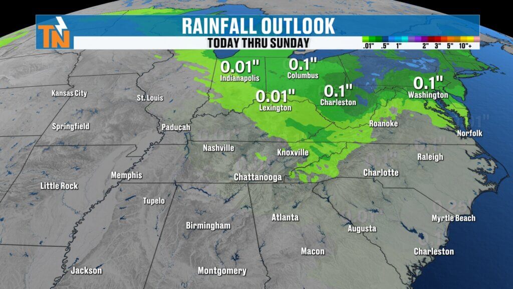
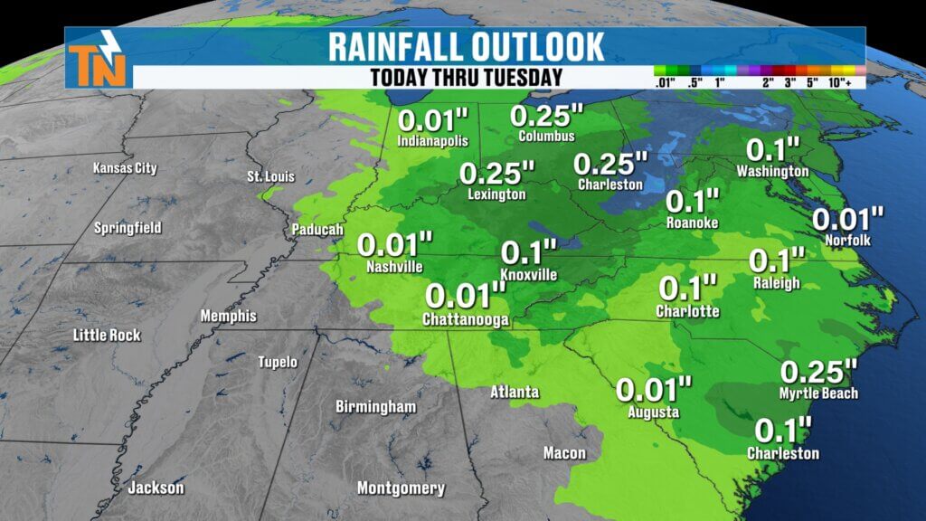
Limited Rainfall Over the Next Week
One of the key takeaways in this forecast is the lack of significant rainfall.
Over the next 5 to 7 days:
Overall dry pattern continues
Only isolated light rain chances
No major storm systems expected until after the weekend
Cold Night Ahead
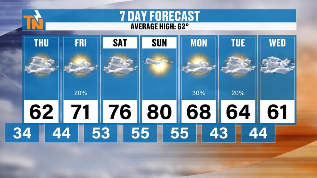
OnceEast Tennessee 7-Day Weather Outlook
- Wednesday: Mostly cloudy, slight chance of sprinkles, highs in the 40s and 50s
- Thursday: Warmer with more sunshine, highs in the 60s
- Friday: Sunny and warm, highs in the low to mid 70s
- Saturday: Beautiful spring weather, highs in the mid 70s
- Sunday: Very warm, highs near 80, increasing clouds late
- Sunday Night: Chance of light rain
- Monday: Cooler with highs near seasonal averages
Final Thoughts
After a historic cold day across East Tennessee, we’re finally turning the corner toward warmer weather.
While today remains cool and mostly cloudy, a steady warming trend will take us into a beautiful spring weekend with temperatures pushing near 80 degrees.
Enjoy the sunshine that’s on the way, and get ready for a much more comfortable stretch of weather.
Have a great Wednesday.