
Good morning and happy Thursday, East Tennessee!
I hope you’re having a great start to your day.
Yesterday brought another round of scattered showers and thunderstorms across the region. While some communities picked up a healthy amount of rain, others barely saw a drop. That uneven rainfall pattern is about to change.
Over the next several days, we’ll see multiple disturbances move through the Tennessee Valley, bringing increasing coverage of showers and thunderstorms and a growing concern for localized flooding and flash flooding.
The Weather Pattern Is Becoming More Active
The upper-level trough we’ve been tracking all week continues to slowly shift eastward.
Today’s disturbance will trigger another round of scattered afternoon storms, but an even stronger wave arrives Friday and lingers through the weekend.
That means our rain coverage will steadily increase from today through Monday.
Severe Weather Risk Increases This Weekend
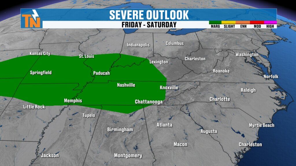
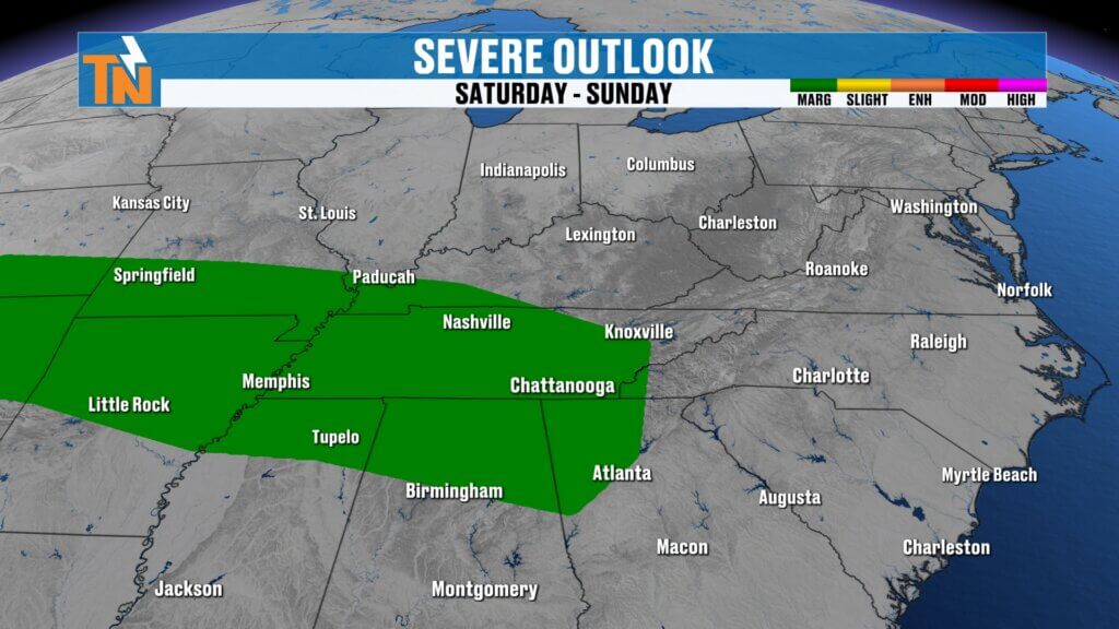
The Storm Prediction Center keeps the greatest severe weather threat just west and northwest of East Tennessee today.
However, beginning Friday and continuing into Saturday, portions of western East Tennessee move into a Level 1 risk for isolated severe thunderstorms.
The primary threats will be:
- Damaging wind gusts
- Frequent lightning
- Torrential rainfall
While widespread severe weather is not expected, a few storms could become strong.
Flooding Becomes the Bigger Concern
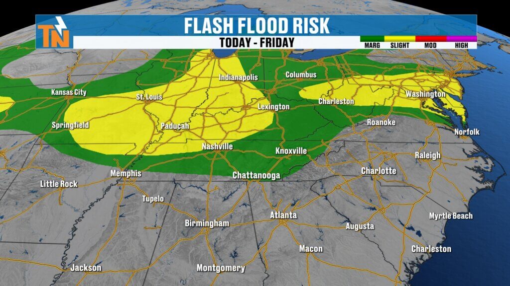
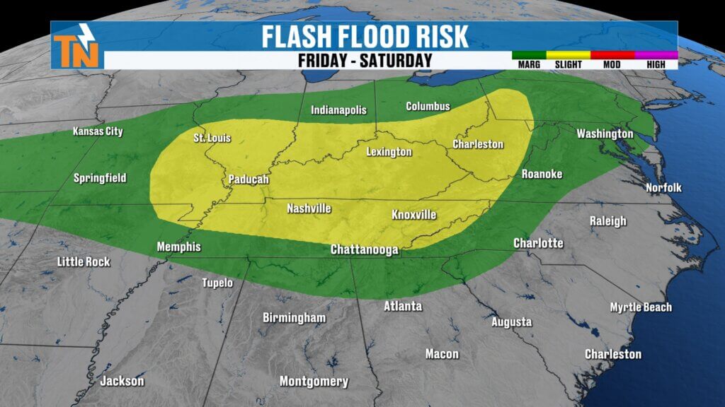
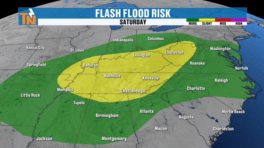
With tropical levels of moisture increasing across the region, the Weather Prediction Center continues highlighting East Tennessee for excessive rainfall.
Current outlook:
- Thursday: Level 1 flood risk
- Friday: Level 2 flood risk
- Saturday: Level 2 flood risk
Forecast guidance places one of the heavier rainfall corridors from western Kentucky through Nashville, Chattanooga, and into the Knoxville area.
Rainfall Totals
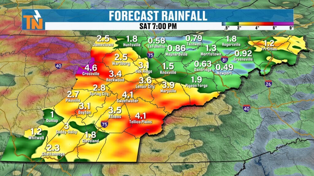
Through Monday, many locations could receive:
- 2 to 3 inches of rain
- Locally higher totals where storms repeatedly move over the same areas
Keep in mind these are broad forecast averages.
One slow-moving thunderstorm could easily drop several inches of rain in a short amount of time.
If you’ve already received heavy rainfall this week, it won’t take much additional rain to create flooding issues.
Flood Watches
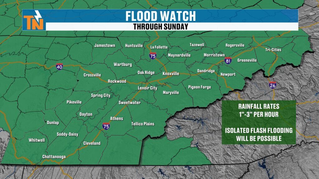
Flood Watches have already been issued for portions of the Cumberland Plateau by the National Weather Service office in Nashville.
The Morristown forecast office is monitoring conditions closely and may issue additional Flood Watches as confidence increases in the heavier rainfall expected Friday through Sunday.
Today’s Forecast
The morning starts fairly quiet, although a few isolated showers are possible.
Storm coverage gradually increases through the afternoon before tapering off later this evening.
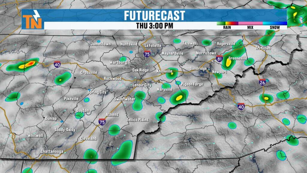
Today’s timeline
- Morning: Mostly dry with isolated showers
- Around lunchtime: Storms begin developing
- Afternoon: Scattered showers and thunderstorms
- Evening: Storms gradually diminish
Storms will move a little faster than they have over the past several days, but they’ll still be capable of producing locally heavy rainfall.
Temperatures
Morning temperatures begin in the upper 60s and 70s.
A slightly stronger breeze develops this afternoon.
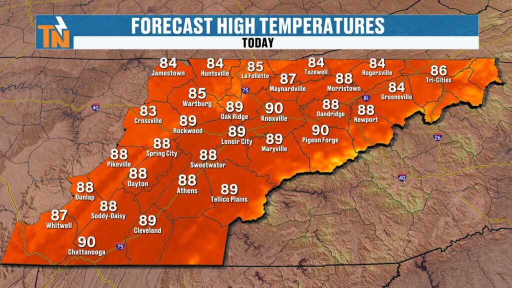
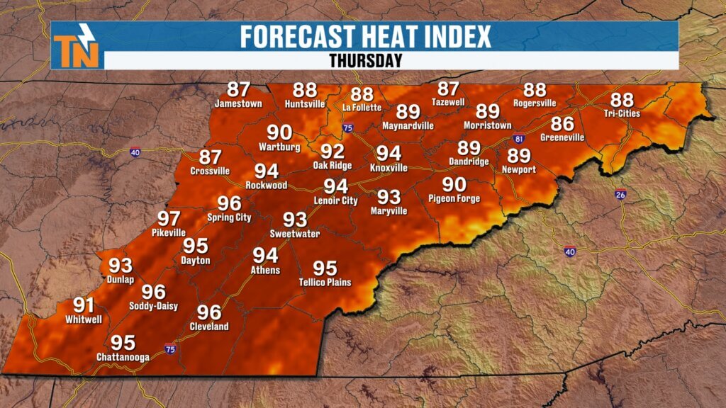
High temperatures reach the upper 80s to near 90 degrees, which is right where we expect to be for this time of year.
Heat index values climb into the middle 90s, thanks to continued high humidity.
Even this evening remains warm and muggy, with temperatures still around 84° at 7 PM.
Friday Through Sunday
Beginning Friday, rainfall coverage increases significantly.
Showers and thunderstorms become much more widespread during the afternoon and evening before continuing into Friday night.
Saturday looks even wetter.
Several rounds of showers and thunderstorms are expected throughout the day, making outdoor plans difficult.
Additional rounds of rain continue Saturday night into Sunday, keeping the flood threat elevated across much of East Tennessee.
Rain Chances
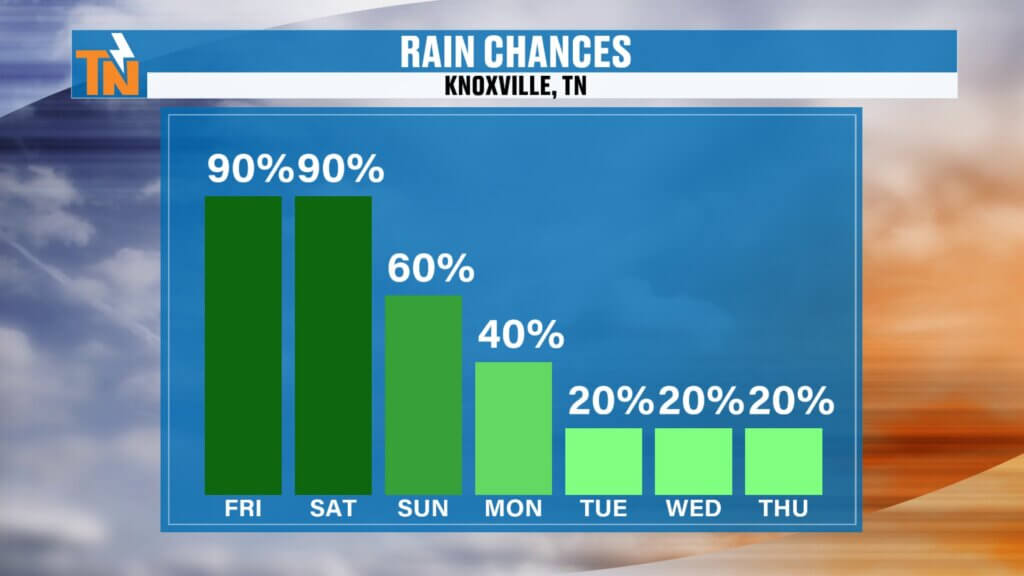
- Thursday: 40%
- Friday: Near 100%
- Saturday: Near 100%
- Sunday: Numerous showers and thunderstorms
- Early next week: Rain chances gradually decrease
Seven-Day Outlook
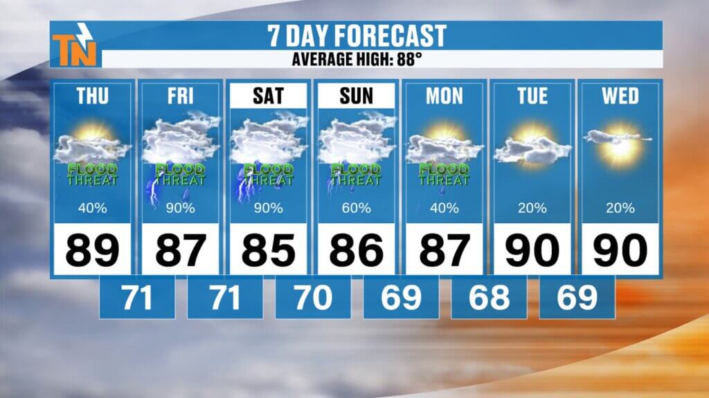
Temperatures remain seasonably warm with highs generally in the upper 80s and occasional lower 90s.
Humidity remains high with dew points in the lower to middle 70s, keeping heat index values in the 90s despite the increased cloud cover.
The biggest weather story through Monday will be repeated rounds of heavy rain capable of producing localized flooding.
Drier weather is expected to gradually return during the middle of next week.
Bottom Line
Today’s weather is manageable with scattered afternoon thunderstorms.
The bigger concern begins Friday and lasts through the weekend as multiple disturbances move through East Tennessee.
Expect:
- Increasing coverage of showers and thunderstorms
- Tropical-like downpours
- Localized flooding and flash flooding concerns
- A few isolated strong thunderstorms
- Warm, humid conditions throughout the period
If you’ll be traveling, attending ballgames, heading to the lake, or making weekend plans, stay weather aware and keep a close eye on radar.
The East Tennessee Weather App remains the best way to receive weather alerts, monitor interactive radar, and stay updated wherever your weekend takes you.
Have a fantastic Thursday, and thanks for making East Tennessee Weather part of your morning!