
Flood Threat Shifts South Thursday as More Rounds of Rain Target East Tennessee This Weekend
Happy Thursday, East Tennessee!
I hope you’re having a great start to your day.
The weather pattern hasn’t changed much this week, and that’s why our forecast continues to feature scattered showers and thunderstorms. The difference today is that the heaviest rain is shifting farther south as a stalled front slowly sags through the region.
While many communities north of Interstate 40 will finally catch a bit of a break, flooding concerns remain elevated across the southern half of East Tennessee, with additional rounds of rain expected heading into the weekend.
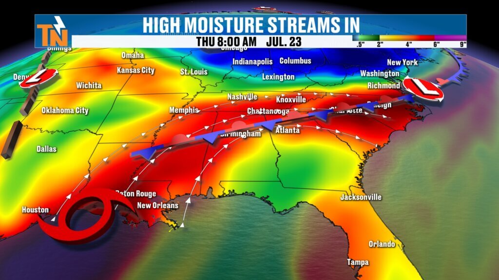
The Weather Pattern Isn’t Going Anywhere
The same large-scale pattern that’s been in place all week continues to drive our forecast.
A strong ridge of high pressure remains anchored over the Four Corners, while a broad upper-level trough stretches from the Great Lakes into the Tennessee Valley. That setup allows disturbances to ride over the ridge before diving southeast into our area.
Each one of those disturbances will help trigger scattered showers and thunderstorms Friday and Saturday.
At the surface, a stalled frontal boundary remains the focus for the heaviest rainfall. That front has been slowly drifting south over the past couple of days, and wherever it sets up is where the heaviest rain will develop.
Adding even more moisture to the atmosphere is Tropical Storm Bertha, which continues moving toward the Texas coast. While the storm itself won’t impact East Tennessee directly, tropical moisture circulating around it will continue streaming into the Southeast, helping fuel periods of heavy rainfall.
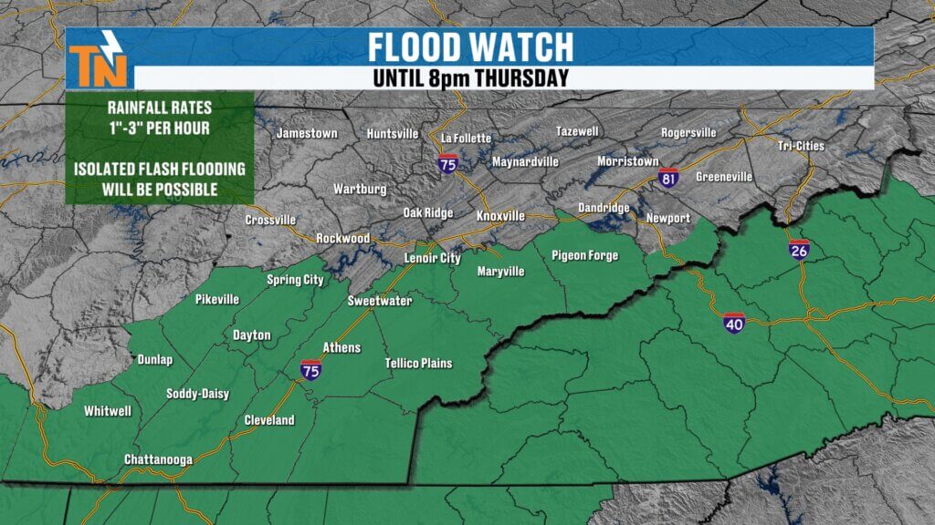
Flooding Concerns Shift South
As the front sags farther south today, so does the flood threat.
The Weather Prediction Center continues to highlight areas south of Interstate 40 with a Level 1 and Level 2 risk for excessive rainfall, and the National Weather Service has a Flood Watch in effect through 8:00 PM for portions of southern East Tennessee.
Rainfall rates of 1 to 3 inches per hour remain possible within the strongest storms.
Early this morning, parts of Monroe and McMinn counties were already dealing with heavy rain and Flood Advisories, a reminder that it won’t take much for localized flooding to develop.
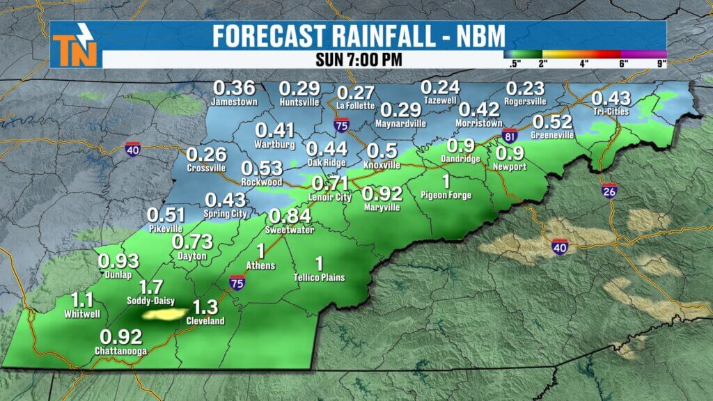
Not Everyone Will See Heavy Rain
One of the biggest challenges with today’s forecast is the highly localized nature of the rainfall.
The heaviest rain yesterday fell along and just north of Interstate 40.
Today, that axis shifts southward, focusing the greatest rainfall potential:
- South of Interstate 40
- Along the foothills
- Across the mountain counties
- South of Interstate 81
Could a few showers still develop farther north? Absolutely. But the better chance for repeated heavy rain will remain across southern sections of East Tennessee.
Much like the past few days, storms will have a tendency to “train,” meaning multiple showers move over the same locations from southwest to northeast, increasing the risk for localized flooding.
Comfortable North, Tropical South
There is a noticeable difference in the air mass across East Tennessee this morning.
Communities near the Tennessee-Kentucky border and across portions of the northern Plateau are enjoying slightly lower humidity thanks to a pocket of drier air.
Meanwhile, the southern Valley remains locked in the tropical air mass with much higher dew points and noticeably muggier conditions.
That humidity gradient will continue to separate the drier air to the north from the deeper tropical moisture farther south throughout the day.
Temperatures Stay Below Average
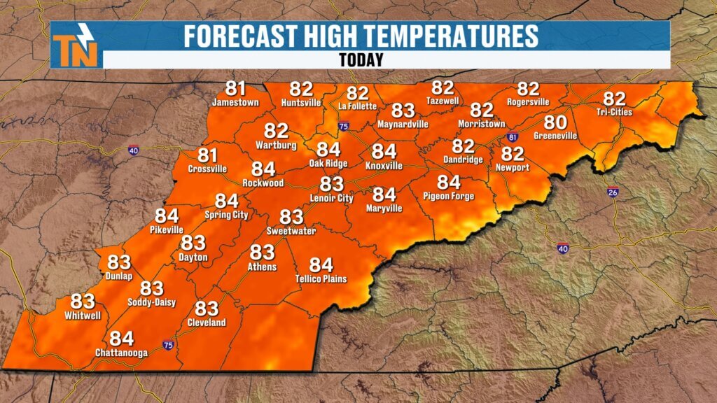
Clouds and scattered rainfall will help keep temperatures in check once again.
Most communities will top out in the lower to middle 80s, making today feel much more comfortable than earlier this week.
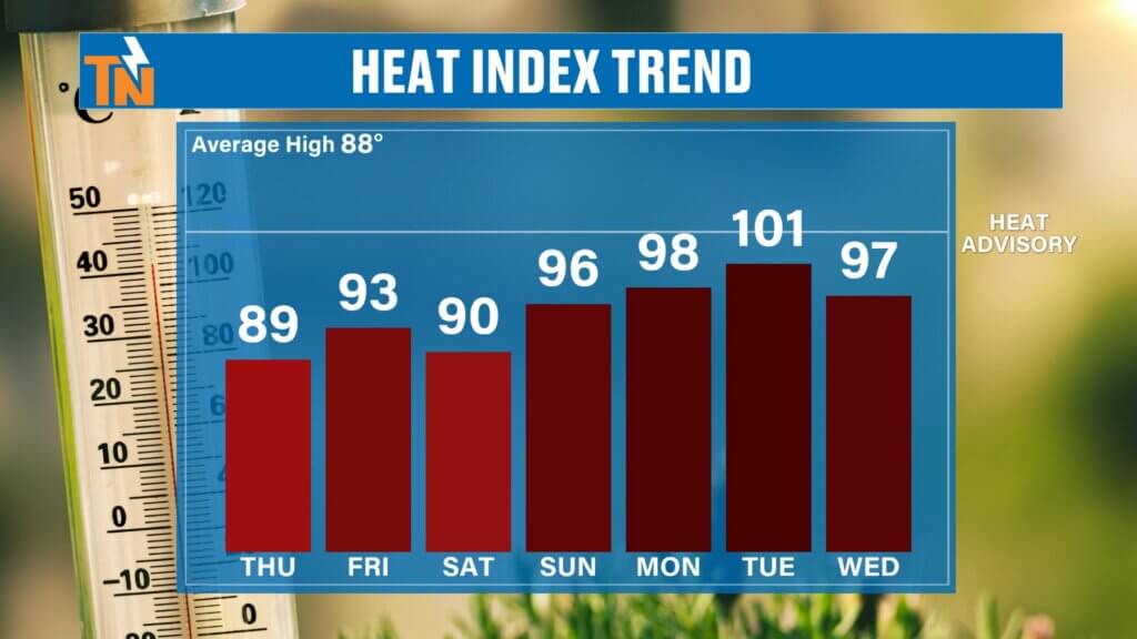
Heat index values will remain fairly modest compared to recent days, thanks to the cooler temperatures and cloud cover.
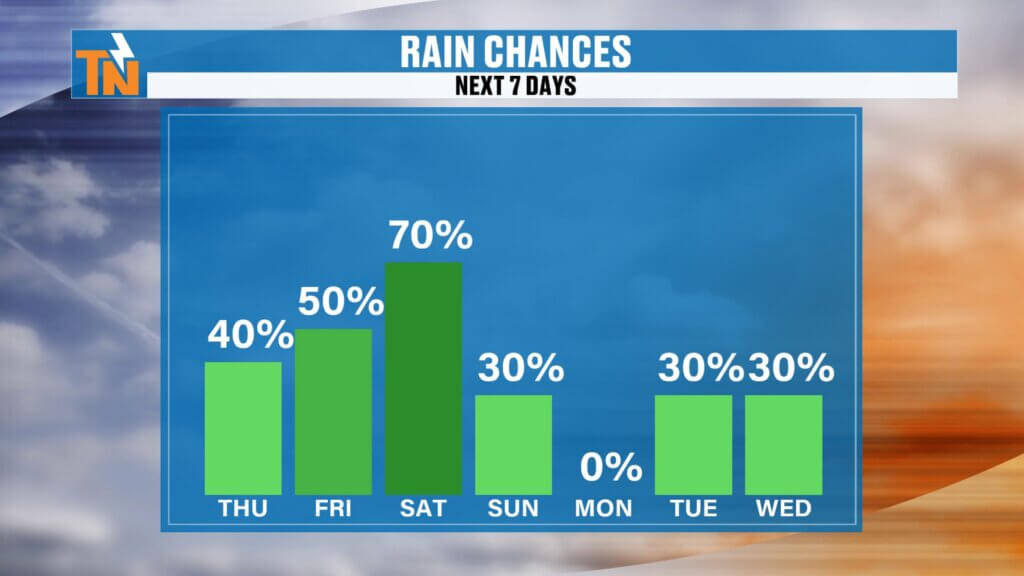
More Rain Ahead This Weekend
Unfortunately, today’s rain isn’t the end of this active pattern.
Another disturbance arrives Friday, bringing scattered showers and thunderstorms back into the forecast.
Rain chances increase even more on Saturday as another wave rotates through the upper-level trough.
Current expectations are:
- Friday: Scattered afternoon showers and thunderstorms.
- Saturday: Highest rain coverage of the weekend.
- Sunday: Lower rain chances with more dry time and a better opportunity for outdoor activities.
While no day looks like a complete washout, you’ll want to keep the umbrella nearby if you have weekend plans.
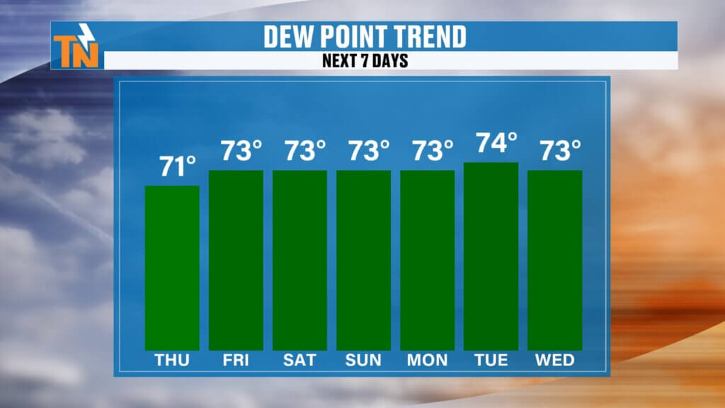
Humidity Builds Again
Today’s brief dip in humidity won’t last long.
As we head into the weekend, dew points climb back into the middle 70s, bringing back that familiar tropical feel.
Temperatures will remain fairly comfortable through Saturday, but as highs begin climbing again early next week, heat index values will once again approach 100 degrees.
Looking Ahead
The overall weather pattern remains unchanged.
As long as the ridge stays parked across the western United States and the trough remains over the eastern half of the country, East Tennessee will continue seeing periodic disturbances capable of producing scattered showers and thunderstorms.
That means rain chances aren’t disappearing anytime soon.
The Bottom Line
Today’s heaviest rain shifts south of Interstate 40 as a stalled front slowly settles farther into the southern Tennessee Valley.
Flooding remains the primary concern where repeated heavy showers develop, especially across the southern Valley, foothills, and mountain communities.
Rain chances remain elevated Friday and peak again on Saturday before Sunday offers the best opportunity for drier weather and outdoor plans.
Keep the free eastTNweather app nearby today so you can monitor interactive radar, receive lightning alerts, and stay informed if Flood Advisories or Flash Flood Warnings are issued for your location.
Have a great Thursday, stay weather aware, and thanks for trusting eastTNweather as your source for weather across East Tennessee.