
Published: Monday, August 31, 2026
By Meteorologist Mike Witcher | eastTNweather
Monday, August 31, 2026 | Meteorologist Mike Witcher | eastTNweather
Good morning and Happy Monday!
Hopefully you had a fantastic weekend, because it was certainly a toasty, roasty one across East Tennessee.
And if you’re waiting for cooler weather to arrive just because meteorological fall begins Tuesday… Mother Nature didn’t get the memo.
A strong ridge of high pressure — our heat dome — continues to dominate the weather pattern this week. That means plenty of sunshine, very few thunderstorms and temperatures climbing well into the 90s.
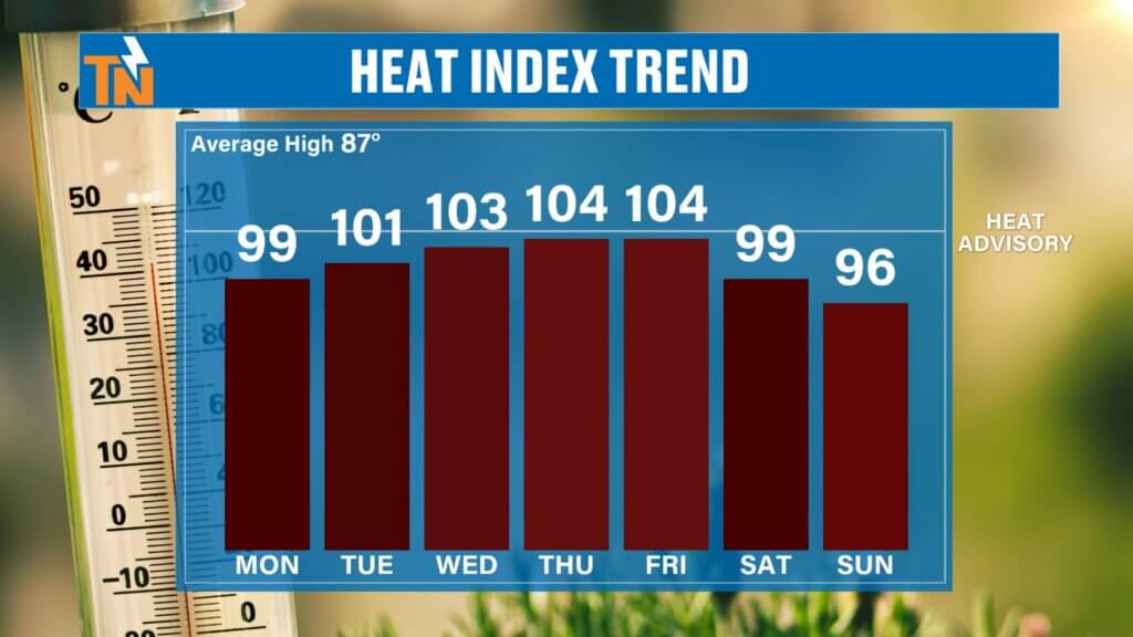
In fact, Wednesday and Thursday could be our hottest days of the week, with heat index values potentially reaching 100–105° in portions of East Tennessee.
But there is a subtle pattern change showing up as we approach Labor Day weekend.
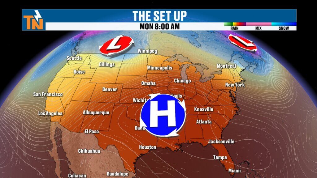
Heat Dome Dominates This Week
The big weather story remains the upper-level ridge parked across the region.
Underneath that ridge, sinking air makes it difficult for widespread showers and thunderstorms to develop.
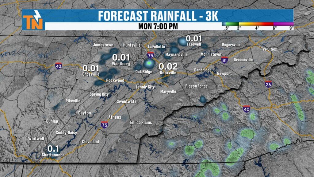
That’s why I’ve removed the 20% rain chances I had been carrying through portions of the week.
Could a rogue shower or thunderstorm develop?
Absolutely.
But they’ll be so few and far between that the overwhelming majority of East Tennessee will remain dry.
If something does manage to pop today, the Smokies, Cumberland Plateau and other higher terrain would have the better opportunity.
Otherwise, expect plenty of sunshine and heat.
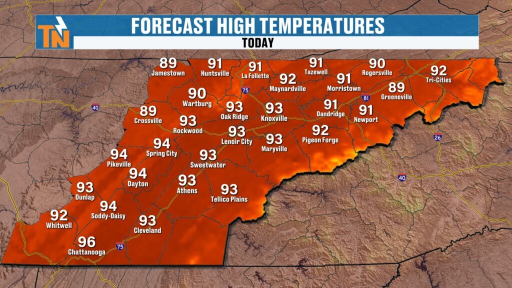
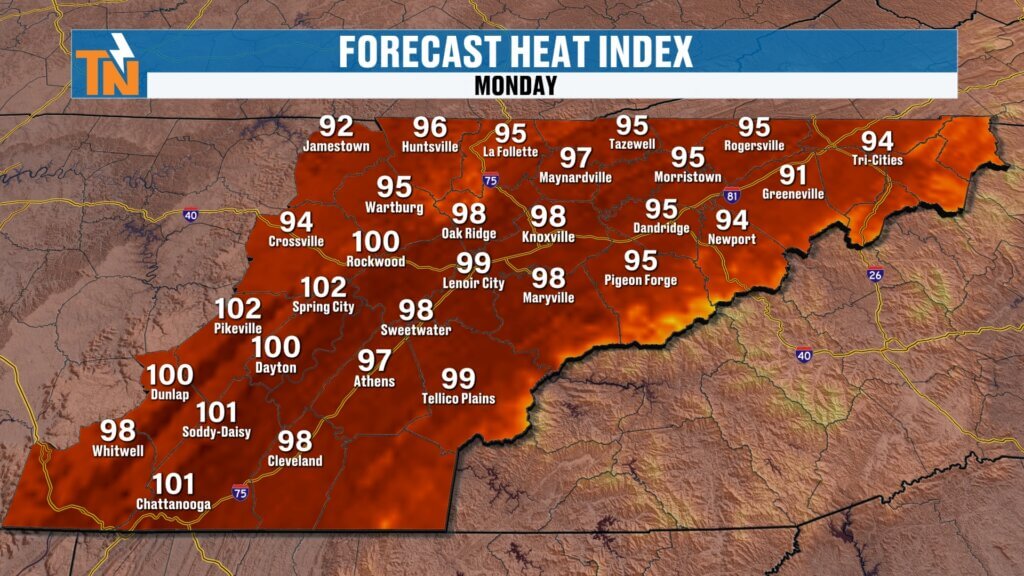
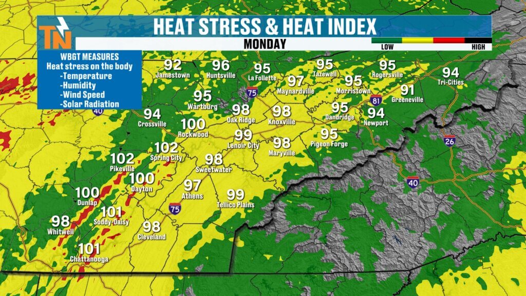
Low to Mid 90s Today — And Feeling Hotter
We’re starting Monday in the 60s and 70s with another mild and muggy morning.
Temperatures quickly climb from there.
Highs this afternoon should reach the low to middle 90s, but dew points in the upper 60s and lower 70s will make it feel hotter.
Heat index values will generally reach the upper 90s and lower 100s.
Winds will also remain light underneath the ridge, adding to that stagnant late-summer feel.
If you’ve got evening plans, conditions slowly improve after sunset. We’ll still be around 89° at 7 PM, falling toward 82° by 9 PM.
It’s hot.
But technically, it’s still summer for one more day!
Wednesday & Thursday Could Be the Hottest Days
We’re going to keep turning the thermostat up over the next few days.
Right now, Wednesday and Thursday look like the hottest days of the week.
Actual temperatures will climb into the low and middle 90s, but when you combine that with the humidity, portions of the region could experience heat index values around 100–105°.
The Southern Valley will be especially important to watch, including Chattanooga and surrounding communities.
The National Weather Service has indicated that Heat Advisory conditions may become possible across portions of central and southern East Tennessee if current trends continue.
Even if an advisory isn’t issued for your particular county, don’t get caught up in the boundary of an alert.
It’s going to be HOT.
Take breaks if you’re working outside, stay hydrated and keep an eye on kids participating in outdoor sports and practices.
Meteorological Fall Starts Tuesday… Sort Of
September 1 marks the beginning of meteorological fall.
But don’t expect pumpkin-spice weather Tuesday morning.
Meteorologists divide the seasons into three-month periods for easier climate record keeping, so meteorological fall consists of September, October and November.
Astronomical fall doesn’t arrive until later in September.
And based on the pattern we’re seeing, summer temperatures aren’t going anywhere anytime soon.
A Pattern Change Heading Into Labor Day Weekend
Here’s where things get interesting.
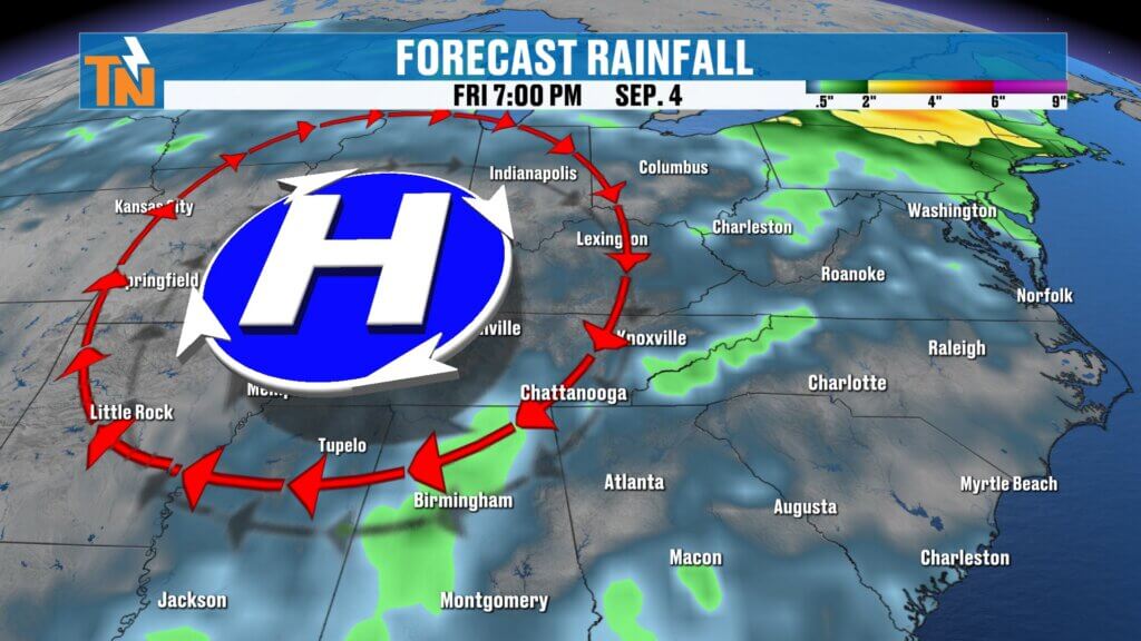
The upper-level ridge doesn’t completely disappear, but its center begins shifting north and northwest later this week.
That becomes important because it could put East Tennessee back into more of a northwesterly flow.
And we’ve talked about northwesterly flow quite a bit this summer.
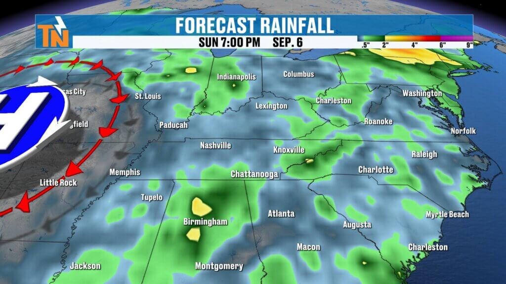
Disturbances riding around the edge of the ridge can dive southeast toward the Tennessee Valley, bringing opportunities for showers and thunderstorms.
Our first increase in rain chances appears to arrive around Friday, with another upper-level disturbance potentially influencing our weather through portions of the weekend.
But there’s an important message here:
I’m NOT calling Labor Day weekend a washout.
We’re simply seeing a pattern that becomes more favorable for at least a few showers and thunderstorms compared with the extremely dry weather earlier in the week.
Timing will become much clearer over the next several days.
Big Weekend Across East Tennessee
And that timing matters because we’ve got plenty happening this weekend.
The Monroe County Hot Air Balloon Festival takes place Saturday and Sunday, and the Big Kahuna Wing Festival is Sunday.
I’ll be at both events with eastTNweather, so believe me — I’ll be watching this weekend forecast closely!
Right now, keep your plans.
As we get closer, we’ll fine-tune the timing and coverage of any showers or thunderstorms that could impact outdoor events.
Great Lake Weather This Week
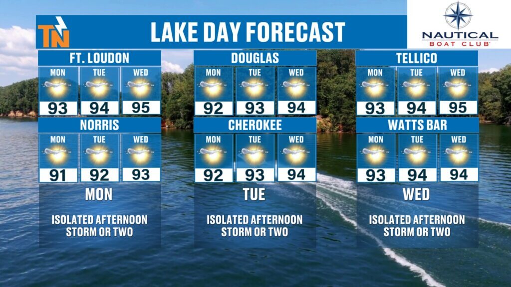
If you’ve got an opportunity to get out on the water this week, you’re in pretty good shape.
With very limited rain chances and temperatures in the 90s, Norris, Douglas, Cherokee, Fort Loudoun, Tellico and Watts Bar are all going to look awfully inviting.
Just remember the sun and heat.
UV levels will be high, so sunscreen, hydration and frequent breaks are important even when you’re surrounded by water.
And despite the very low storm chances early this week, keep the eastTNweather app handy for interactive radar and lightning information.
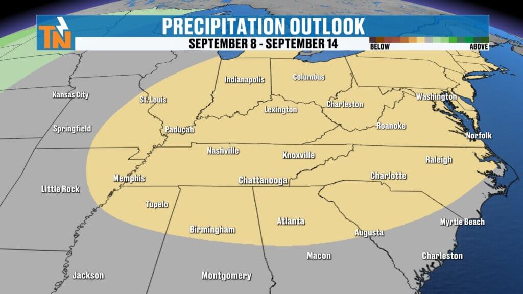
September Could Start Hot & Dry
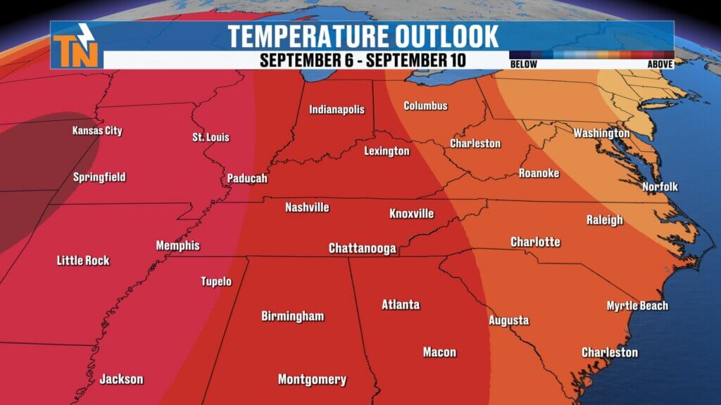
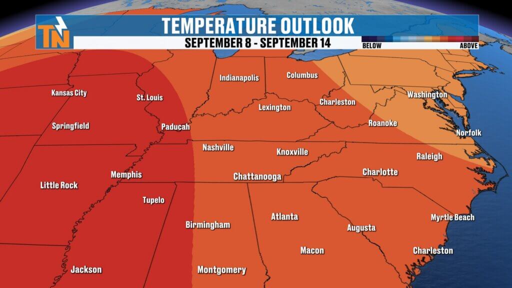
Looking beyond the seven-day forecast, there’s not much evidence of a significant cooldown.
The overall ridge pattern may continue influencing our weather through at least the first couple of weeks of September, favoring above-average temperatures.
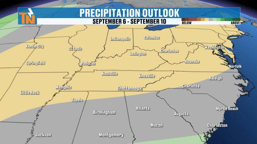
We’re also entering a naturally drier portion of the year.
September begins our transition toward the driest part of the calendar, with October typically our driest month.
The good news is that the abundant rainfall we’ve received this summer helped improve drought conditions before entering this traditionally dry stretch.
Now we’ll watch closely to see how long this hotter and drier pattern sticks around.
Bottom Line
MONDAY: Mostly sunny, hot and mainly dry. Highs low to mid 90s with heat index values near 100° in spots.
TUESDAY: Meteorological fall begins, but it certainly won’t feel like it. Hot and mostly dry.
WEDNESDAY–THURSDAY: Likely the hottest stretch of the week. Heat index values could reach 100–105°, especially farther south.
FRIDAY: Pattern begins changing with increasing opportunities for showers and thunderstorms.
LABOR DAY WEEKEND: Still hot with at least some opportunity for scattered storms. Do not cancel outdoor plans.We’ll fine-tune the timing as we get closer.
Keep checking back throughout the week because I’ll be watching both the increasing heat and those Labor Day weekend rain chances.
Make sure you download the FREE eastTNweather app for your local forecast, interactive radar, current conditions and weather alerts wherever you go.
And if you’re watching on YouTube, please LIKE, SHARE and SUBSCRIBE, and hit that bell on my YouTube channel so you’re notified whenever I post a new forecast.
I’m Meteorologist Mike Witcher.
Have a fantastic Monday!
eastTNweather — Weather When You Want It.
East Tennessee weather, Knoxville weather, Labor Day weekend weather Tennessee, East Tennessee Labor Day forecast, Knoxville Labor Day weather, Tennessee heat wave, East Tennessee heat dome, Knoxville heat index, Chattanooga heat advisory, Tennessee heat advisory, East Tennessee weekend forecast, Knoxville weekend forecast, meteorological fall 2026, Tennessee September forecast, East Tennessee thunderstorms, Tennessee lake forecast, Smoky Mountains weather, Mike Witcher, eastTNweather
#eastTNweather #TNwx #KnoxvilleWeather #EastTennessee #HeatWave #HeatDome #HeatAdvisory #LaborDayWeekend #LaborDayWeather #MeteorologicalFall #Knoxville #Chattanooga #SmokyMountains #TennesseeWeather #WeekendWeather #MikeWitcher