
Good morning and happy Thursday, everybody.
Thanks for checking in this morning.
If you enjoyed yesterday, you weren’t alone.
It was another beautiful below-average day across East Tennessee with comfortable air, lower humidity, and plenty of sunshine.
But today marks the beginning of a big transition.
Humidity is coming back.
Rain chances increase heading into the weekend.
And next week?
We’re talking about some serious summer heat.
Let’s break it all down.
Comfortable Start, But Changes Are Already Beginning
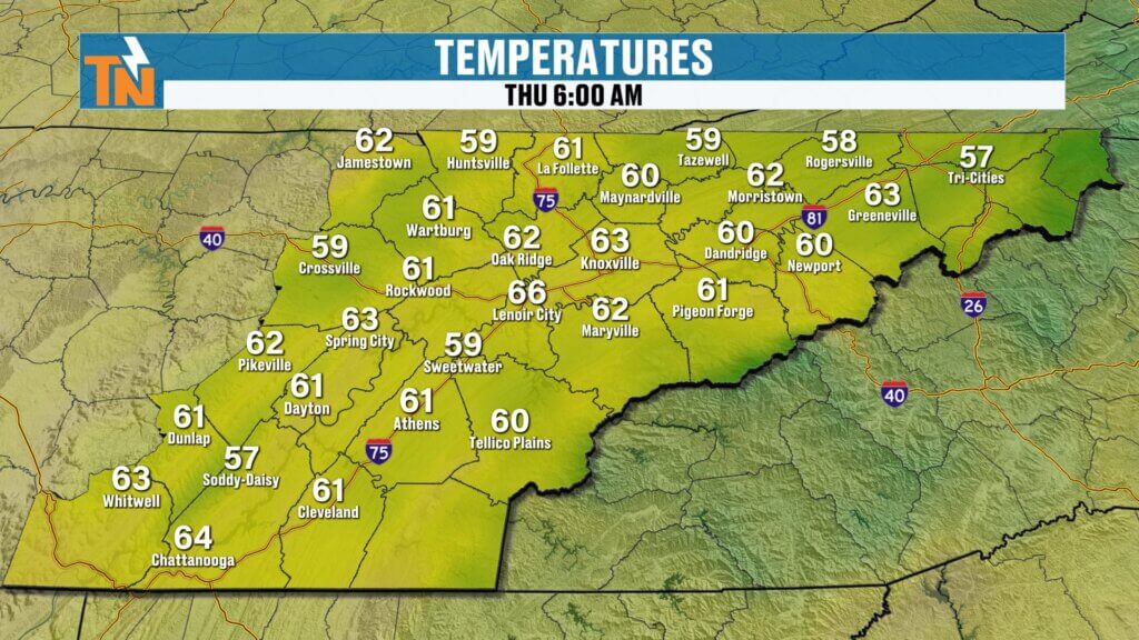
This morning starts off fairly quiet across East Tennessee.
We’ve got a few high thin clouds moving overhead thanks to showers and thunderstorms down to our south.
Other than that, things are calm.
A little patchy fog is showing up around rivers, lakes, and low-lying areas, but nothing widespread.
Temperatures are also starting warmer than yesterday.
Most spots are waking up in the low to mid 60s.
Still comfortable.
But you can feel the process beginning.
The air is starting to moisten up.
And that’s the setup for what’s coming.
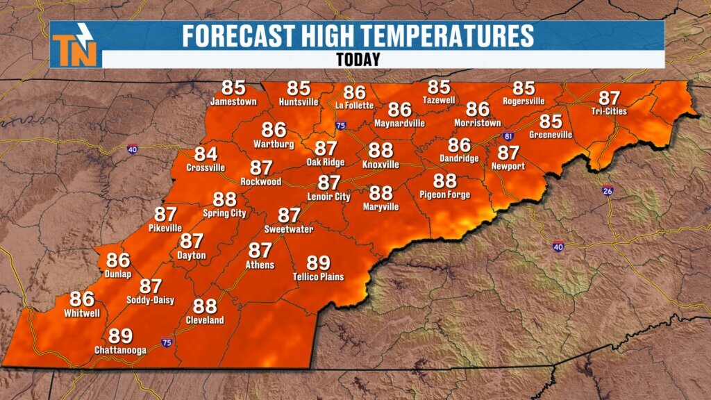
Thursday Forecast: Warm, Mostly Dry, and More Humid
Through the day today, expect morning clouds to gradually thin out.
That will give way to more sunshine this afternoon.
Winds stay light with just a slight breeze.
Temperatures climb back into the mid to upper 80s.
For Knoxville, we’re forecasting a high near 88 degrees.
That’s right near average for late June.
The difference today compared to yesterday?
Humidity.
It’s not oppressive yet.
But it will be noticeably higher.
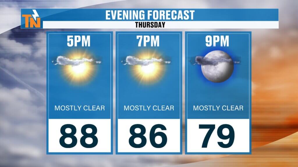
By this evening, temperatures will still be holding near 86 degrees around 7 PM.
Warm, a bit stickier, but still manageable.
Stormy Pattern Returns This Weekend
The overall weather pattern is shifting.
Right now, we’re in what meteorologists call a zonal flow.
That simply means the jet stream is moving west to east.
But inside that flow are little disturbances.
And those disturbances will be our rain-makers heading into the weekend.
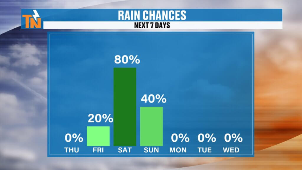
Here’s how it breaks down:
Friday:
A few scattered showers and thunderstorms possible.
Friday night into Saturday morning:
Rain chances increase.
Saturday afternoon:
More scattered showers and storms.
Sunday:
Higher rain coverage with additional storms developing.
Important note:
This does NOT look like an all-day washout.
But it does mean you’ll want to check radar before outdoor plans.
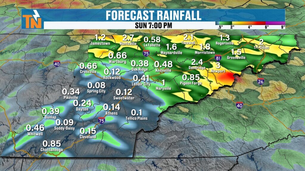
Best Rain Chances Favor Northern East Tennessee
Latest model guidance continues to focus the heaviest rainfall north of Interstate 40.
That includes:
- Morristown
- Greeneville
- Kingsport
- Johnson City
- Areas along Interstate 81
- Tennessee/Kentucky border counties
If you live in those areas, your odds of seeing rain Friday through Sunday are higher.
Further south across the Southern Valley?
Rain chances are lower.
But not zero.
Rainfall totals through Sunday:
Generally around a quarter inch to half an inch.
Locally higher where storms repeatedly move over the same area.
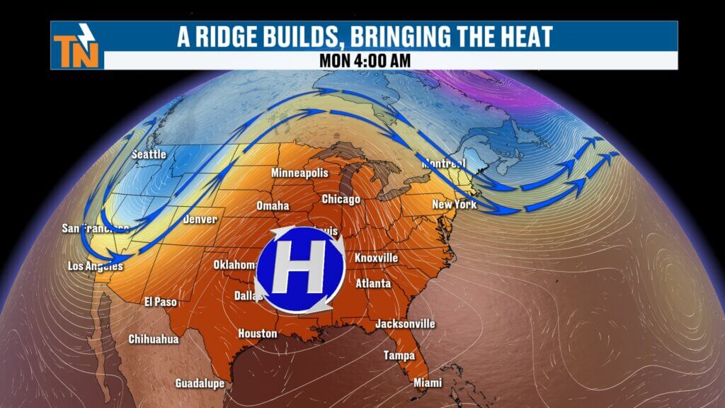
Big Heat Builds Next Week
Once the weekend system exits, the atmosphere changes in a big way.
A strong ridge of high pressure builds over the southeastern U.S.
That’s the classic summer heat dome.
And when that happens:
Rain chances decrease.
Temperatures rise.
Humidity stays high.
That’s when it gets uncomfortable.
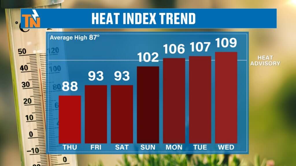
By Monday:
Low 90s.
Tuesday and Wednesday:
Low to mid 90s.
And with dew points staying in the 70s…
Heat index values will likely push near 105 degrees.
That’s near heat advisory criteria.
And it’s something we’ll be watching closely.
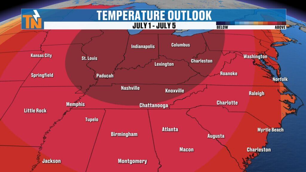
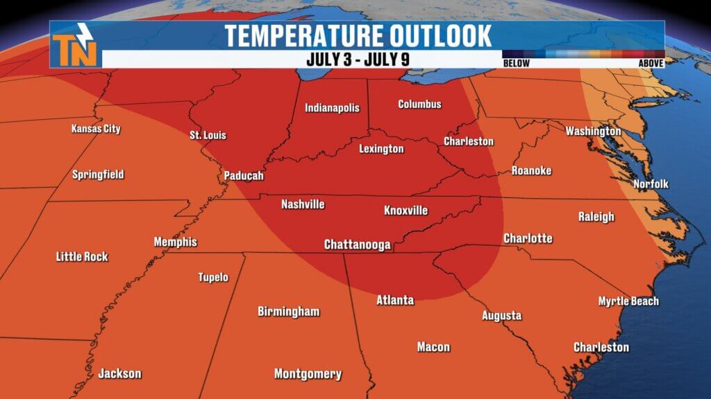
Fourth of July Forecast Trend: Hotter Than Average
The Climate Prediction Center continues to signal above-average temperatures through the Fourth of July and likely into the second week of July.
That means the summer heat is not going anywhere.
This could be our first real prolonged stretch of high-end summer heat.
And we’re just getting started.
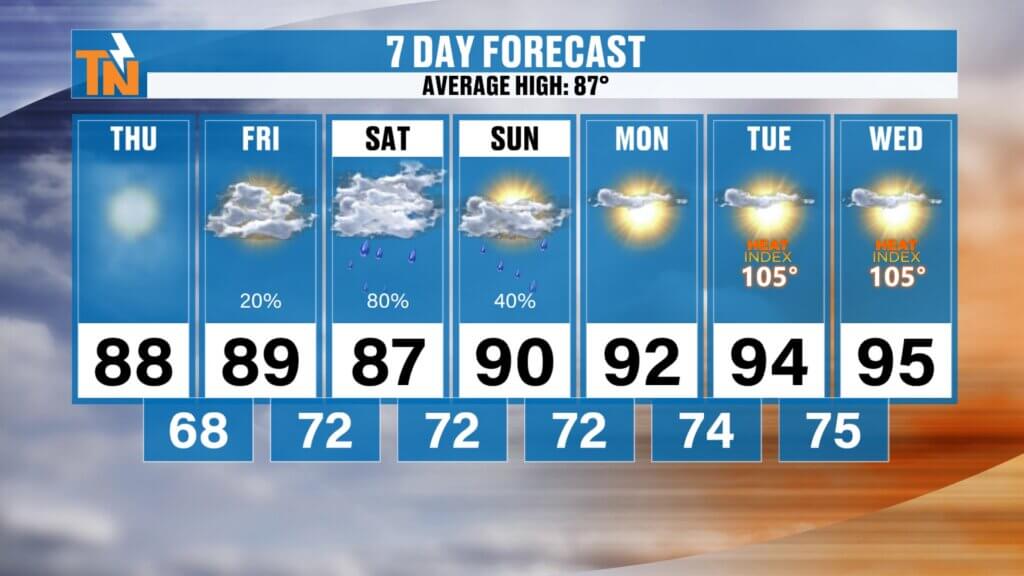
East Tennessee 7-Day Forecast
Thursday
Partly sunny
Warmer and more humid
High: 88°
Friday
Scattered showers and storms
High: 87°
Saturday
Better rain chances
Scattered storms
High: 88°
Sunday
Higher storm coverage
Best chance north
High: 87°
Monday
Hot and humid
High: 91°
Tuesday
Heat builds
Heat index near 100+
High: 94°
Wednesday
Hotter still
Heat index near 105°
High: 95°
Bottom Line
Today is another good weather day.
Warmer.
More humid.
Still mostly dry.
But the weekend brings scattered storms and elevated rain chances.
And next week?
The real summer heat arrives.
So enjoy the manageable temperatures while you can.
Because East Tennessee is about to get a full dose of late June and early July heat.
Have a great Thursday, my friends.
And thanks for checking in this morning.