
Thanks for checking in with your East Tennessee morning weather update. After an absolutely beautiful weekend with sunshine and spring-like warmth — including a high of 75° in Knoxville on Sunday — we’re starting the new week with a shift in the pattern.
Clouds and light rain are moving in today, but don’t expect anything severe. The bigger story? A warming trend continues midweek, followed by increasing rain and thunderstorm chances heading into the weekend.
Let’s break it down.
Weekend Recap: Spring Preview Across the Tennessee Valley
Saturday and Sunday delivered incredible early-March weather across East Tennessee.
- Knoxville topped out at 75° Sunday.
- Morning low was 57°.
- Clear skies and dry conditions dominated.
That warm air mass was well above seasonal averages and gave us a preview of what’s coming later this week.

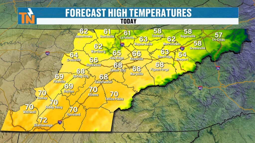
Monday Forecast: Cloudier Skies and Light Rain Mainly North of I-40
As discussed all weekend, a weak disturbance is now swinging through the region.
What to expect today:
- Cloudy skies.
- Light rain showers, mainly north of Interstate 40.
- A few wet roads and sprinkles early.
- No severe weather.
Radar this morning shows rain filling in gradually across the region. The atmosphere will continue to saturate through midday, but rainfall amounts remain modest.
Most areas north of I-40 could pick up up to around two-tenths of an inch. South of I-40, totals will be lighter.
Temperatures remain mild:
- Morning readings in the 40s and 50s.
- Near 60° in Chattanooga.
- Afternoon highs climbing into the mid to upper 60s, possibly low 70s.
That’s slightly cooler than the weekend but still above average for early March.
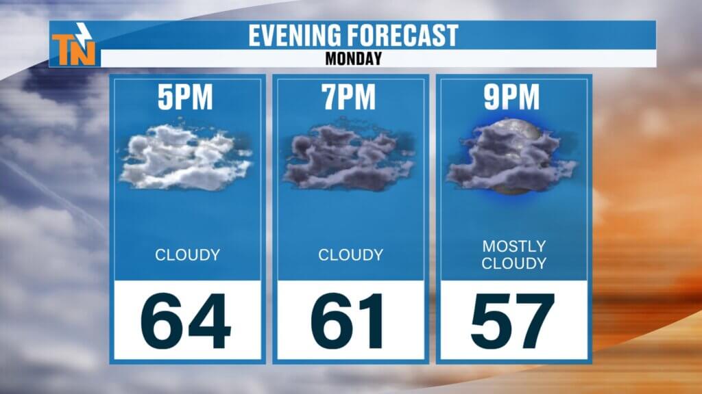
If you have evening plans:
57° by 9 PM.Saturday Forecast: Sunshine, Mild Mornings, and Spring-Like Afternoon Highs
64° around 5 PM.
61° by 7 PM.
We’re starting off on the chilly side this morning, with temperatures in the 30s and 40s across much of the Tennessee Valley. Light jackets are definitely needed early on, but once the sun gets higher in the sky, temperatures will respond quickly.
Afternoon highs:
- 65° Tri-Cities
- 68° Knoxville
- 72° Chattanooga
- 67° Crossville
Expect full sunshine from sunrise to sunset with clear skies and light winds. It’s a picture-perfect early March day across East Tennessee.
If you have evening plans:
- 66° around 5 PM
- Mid-50s by 9 PM
Clear, comfortable, and ideal for dinner plans or outdoor activities.
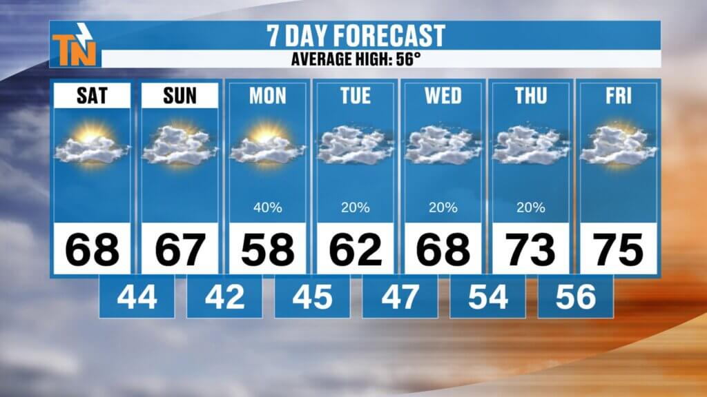
Tuesday: Isolated Showers Possible
Another small wave slides in from the south and southwest Tuesday morning.
Rain chances are lower than today, but:
- A few isolated showers are possible.
- Best chance remains along the Cumberland Plateau and north of I-40.
- No widespread soaking rain expected.
This continues a pattern where the bulk of meaningful moisture remains north and northwest of East Tennessee.
Midweek Pattern: Warm Ridge Builds, Instability Increases
As we move into Wednesday and Thursday, the larger-scale weather pattern becomes more interesting.
We’ll sit under a ridge of high pressure across the Southeast, while a trough digs in to our west. That setup does two important things:
- It allows temperatures to climb well above average.
- It increases atmospheric instability.
With warmer air in place, we can’t rule out:
- A few passing showers.
- Possibly an isolated thunderstorm midweek.
However, most organized rainfall remains west and northwest of our area during this time.
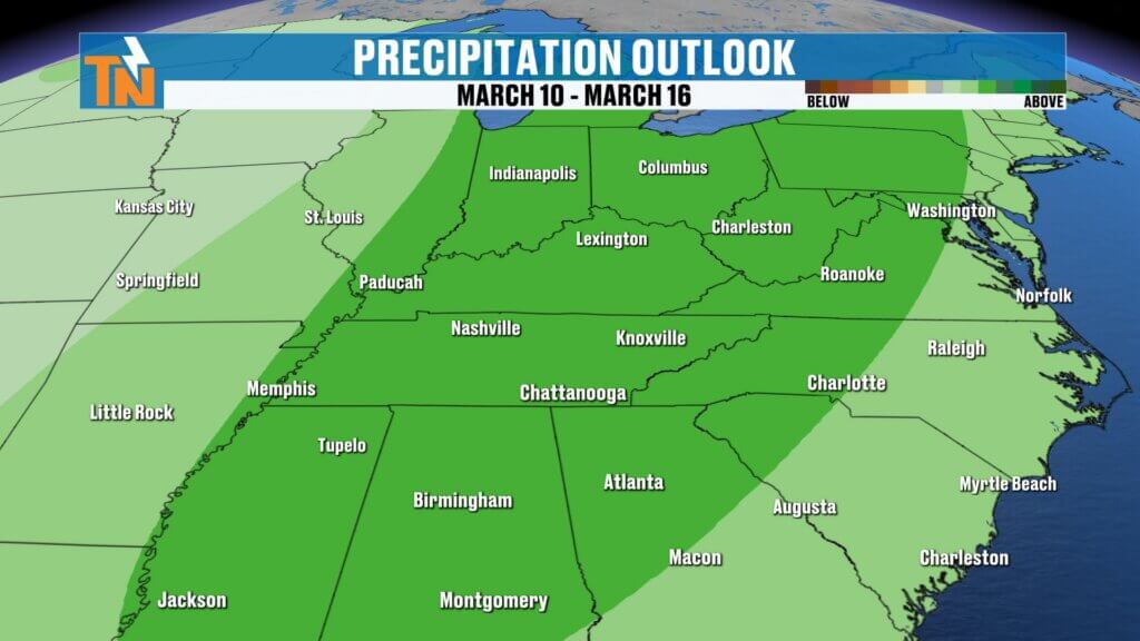
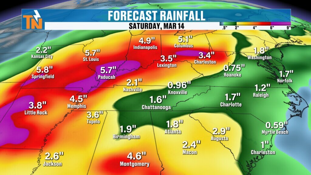
Weekend Storm System: Elevated Rain and Thunderstorm Chances
By Saturday and Sunday, that western trough begins to push eastward.
This is when rain chances begin to climb more noticeably across East Tennessee.
Forecast guidance suggests:
- Increasing shower coverage next weekend.
- Potential for thunderstorms as instability rises.
- Heavier rainfall shifting closer to the Tennessee Valley.
Beyond the 7-day forecast, extended outlooks indicate:
- Continued elevated rain chances.
- Possible rainfall totals of 1 to 2 inches locally.
- Heaviest rainfall focused west of East Tennessee.
Flooding concerns may gradually increase in areas that receive repeated rainfall events, though it’s still early to determine exact impacts.
The timeline for more widespread rainfall stretches toward mid-March, around March 14th. set up along the Tennessee-Kentucky border and farther west into the Ohio Valley.
Next Week: Drier Trend for East Tennessee, Heavier Rain Stays North
Over the past several days, forecast models had hinted at a potentially stronger, drought-busting rain event for East Tennessee. However, updated guidance shows the primary rain shield shifting farther north.
That means:
- Most heavy rainfall remains across the Ohio Valley and central/northern Great Plains.
- East Tennessee sees only scattered, light rain chances.
- Rain probabilities stay around 20% through much of the workweek.
- No widespread soaking event at this time.
This northward shift significantly reduces our rainfall totals compared to earlier projections.
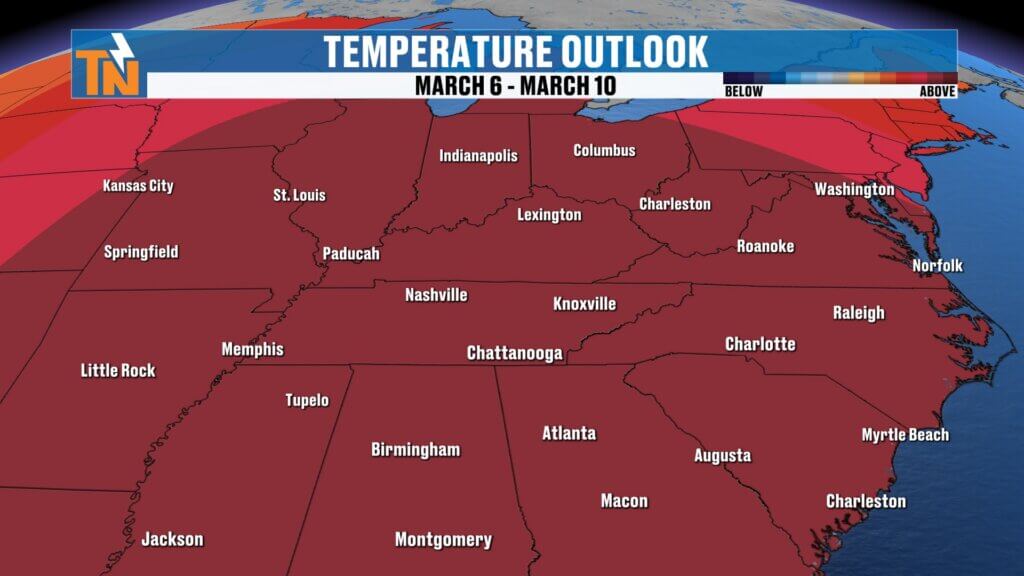
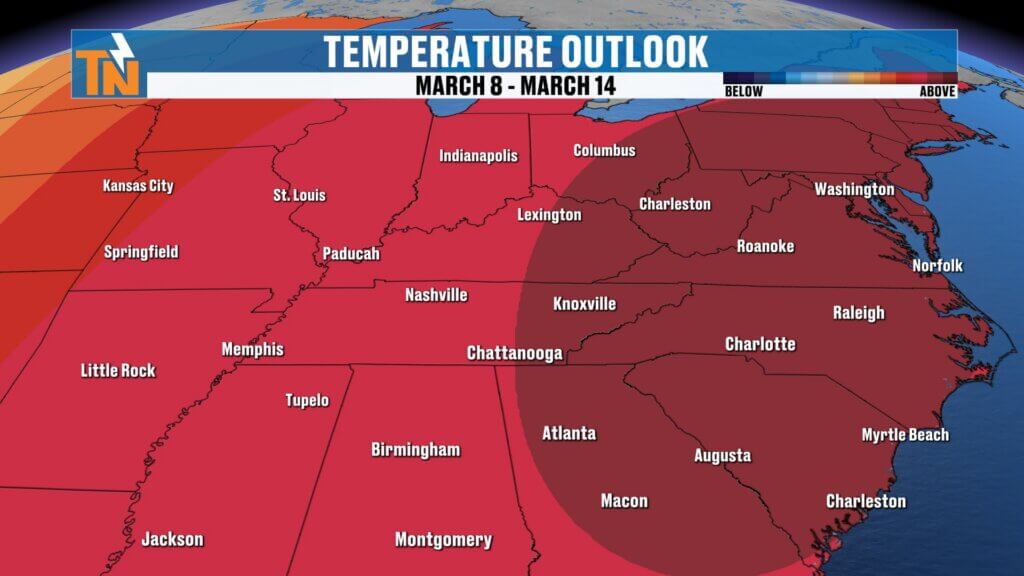
Temperature Outlook: Warmer Pattern Strengthening
Even with occasional clouds and light showers, temperatures are trending impressively warm.
- Upper 60s today and Sunday.
- Slight dip Monday with cooler air behind the weak system.
- Mid to upper 60s midweek.
- Low to mid 70s late next week.
- Potential to push mid to upper 70s — possibly nearing 80° in some spots.
The Climate Prediction Center’s 6–10 day and 8–14 day outlook continues to highlight above-average temperatures across the Southeast, including East Tennessee.
This reinforces the idea that we’re transitioning into a sustained warmer pattern.
Extended Outlook: Increasing Spring-Like Activity
The long-range pattern favors:
- Above-average temperatures.
- Increasing moisture.
- Periodic waves of rain and thunderstorms.
While we’re not looking at severe weather at this time, the transition into a more active spring pattern is underway.
Final Thoughts
To recap:
- Light rain today, mainly north of I-40.
- Isolated showers Tuesday.
- Warmer and slightly unstable midweek.
- Increasing rain and storm chances next weekend.
- Extended pattern trending wetter into mid-March.
Enjoy the mild temperatures today despite the clouds. We’ll continue refining the weekend storm system as we get closer.
Have a great Monday.