
Good morning and happy Thursday, East Tennessee. It’s a soggy and slow-going start across Knoxville, the Tennessee Valley, and communities along the Interstate 40 corridor. But improvements are on the way later today, followed by a beautiful and warmer weekend — before a more active weather pattern returns next week.
Let’s break it all down.
🌧️ Heavy Overnight Rain & Flood Advisories Across the Tennessee Valley
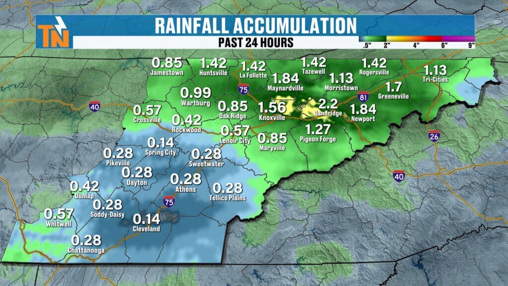
Through the night, widespread rain has soaked much of East Tennessee, especially north of Interstate 40.
- Parts of the central Tennessee Valley have picked up over 1 inch of rain.
- Downtown Knoxville recorded nearly 1.5 inches.
- Along the Tennessee–Kentucky border, rainfall totals exceeded 1 inch, prompting localized flood advisories.
- South of I-40 saw lighter totals, as the heaviest band of rain focused across the central valley.
With saturated ground and standing water in some low-lying areas, use caution during the morning commute. Ponding on roadways and reduced visibility are possible through the morning hours.
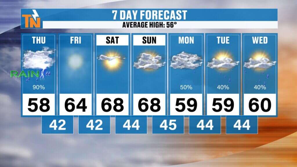
🌤️ Thursday Forecast: Rain Fades, Sunshine Returns
The good news? The steady rain will gradually taper off as we move through the late morning and early afternoon.
- Showers linger through midday.
- Most of the energy shifts south and southeast after lunch.
- A stray shower can’t be ruled out across the foothills and Smoky Mountains this afternoon.
- Partial sunshine develops late day.
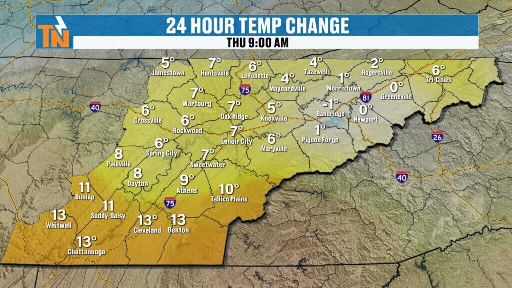
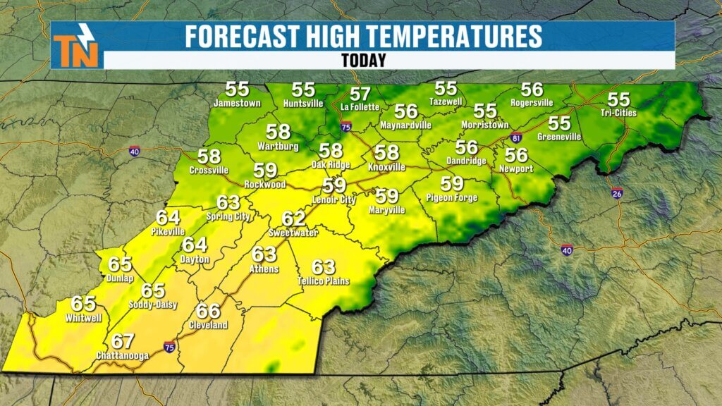
Cloud cover overnight kept temperatures mild this morning, with readings in the 40s and 50s. We’ll warm back into the 50s area-wide today, with some communities south of Knoxville reaching the low 60s.

☀️ Friday & Weekend Outlook: High Pressure Brings Sunshine & Warmer Temperatures
High pressure builds into East Tennessee Friday and through much of the weekend, bringing a welcome stretch of quiet weather.
Friday:
- Morning patchy dense fog possible.
- Clearing skies.
- Highs in the mid to upper 60s.
Saturday:
- Dry and pleasant.
- Upper 60s.
- Excellent outdoor conditions.
Sunday:
- Still warm, upper 60s.
- Increasing clouds late.
- A weak frontal boundary approaches early Sunday morning.
We’ll be in a zonal flow pattern, meaning the jet stream runs west to east just north of us. That keeps colder air bottled up to the north while milder air dominates the Southeast — at least temporarily.Valley and even colder in the higher elevations of the Smoky Mountains and Cumberland Plateau.
🌦️ Late Sunday into Early Next Week: Active Weather Returns
Here’s where things get more interesting.
As we head into Sunday night, Monday, and Tuesday, the weather pattern becomes more active again across the Southeast and Tennessee Valley.
We know:
- Rain chances increase late Sunday into Monday.
- More unsettled weather lingers into Tuesday.
- Cooler air attempts to slide southward.
❄️ Rain or a Brief Wintry Mix?
Some forecast models are hinting at a potential rain/snow line developing somewhere near our region Sunday night. If colder air pushes just far enough south, we could briefly see:
- A quick transition to light snow.
- Or a short-lived rain/snow mix.
- Before reverting back to a cold rain.
At this time, this does not appear to be a significant winter weather event, but it is something we’ll need to monitor closely. Small shifts in temperature profiles can make a big difference this time of year.
Highs early next week have been adjusted downward into the upper 50s instead of the 60s as cooler air filters in.
📅 Extended Forecast: Drying Midweek, Then Another Rain Chance
By Wednesday, we should see some drying and possibly slightly warmer temperatures returning. However, the overall pattern remains somewhat active, meaning additional rain chances could develop later next week.
This is a classic late-winter to early-spring transition pattern for East Tennessee:
- Heavy rain events
- Quick warmups
- Brief cold intrusions
- Uncertainty near the rain/snow line
🔎 East Tennessee Weather Summary
Thursday: Morning rain, clearing late. High near 64.
Friday: Patchy fog early, then sunny and warm. Upper 60s.
Saturday: Dry and pleasant. Upper 60s.
Sunday: Warm, clouds increasing late.
Sunday Night–Tuesday: Increasing rain chances. Watching potential for brief wintry mix.
Midweek: Some drying, temperatures rebound.
These next several days will require close monitoring, especially regarding the Sunday night into Monday system. Small shifts in the track of that boundary will determine precipitation type and temperature trends.
Be sure to check back frequently for updated East Tennessee weather forecasts, radar updates, and possible weather alerts.
Travel safely this morning, especially where heavy rain fell overnight. I’ll keep you posted as we refine the late-weekend forecast.
Have a great day.