
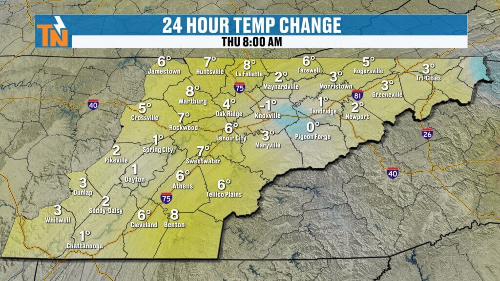
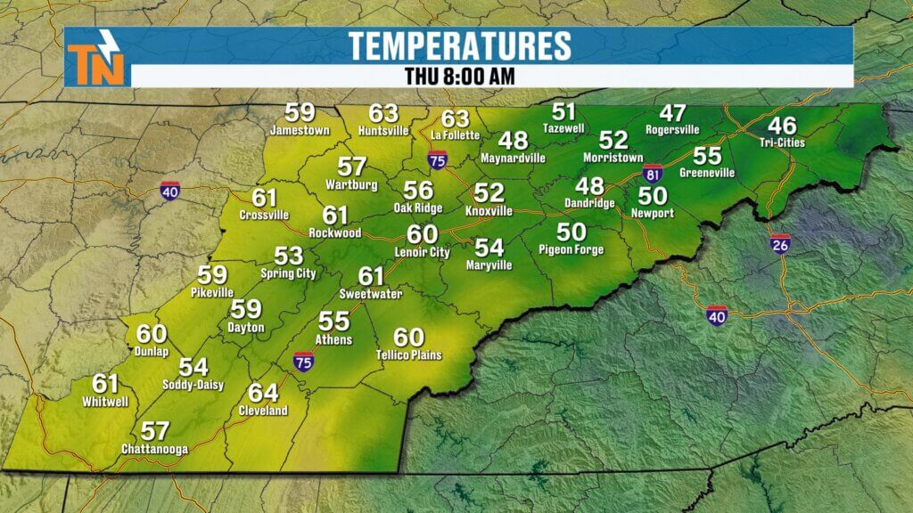
Happy Thursday, East Tennessee. Thanks for checking in with your morning weather update. After another warm day yesterday — with Knoxville topping out at 75° after a morning low in the 40s — the warm spring-like pattern continues today. In fact, near-record temperatures are possible across the Tennessee Valley.
But while the warmth continues for now, changes are coming. A developing storm system to our west will eventually push a cold front toward East Tennessee this weekend, bringing increasing chances for showers and thunderstorms.
Let’s break down the forecast.

Warm Pattern Continues Across the Southeast
A ridge of high pressure over the southeastern United States continues to dominate the weather pattern. This ridge, combined with a strong trough developing across the western U.S., is helping pump warm, moist air northward into Tennessee.
The result is a major warm-up across the region.
Expected High Temperatures Today
- Knoxville: upper 70s to near 80°
- Tri-Cities: mid to upper 70s
- Chattanooga: near 80°
- Across Tennessee: widespread 70s and 80s
Meanwhile, colder air remains locked up well to our north across the Midwest and Great Lakes.
This setup is the reason we’re seeing well above-average temperatures for early March.
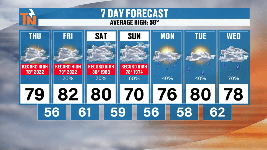
Near-Record High Temperatures Possible
The warmth today and tomorrow could challenge daily record highs in East Tennessee.
Record Temperature Watch
- Thursday: Forecast near 80° (record 78° set in 2022)
- Friday: Forecast around 82° (record 79° set in 2022)
- Saturday: Forecast near 80° (record 80° set in 1983)
While today could approach record territory, Friday currently looks like the best chance to break a record high.
Sunday will likely be cooler as a cold front approaches.
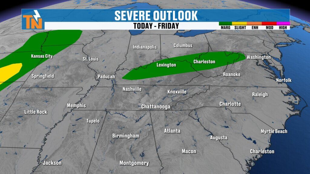
Severe Weather Setup Across the Central U.S.
The large trough developing west of the Mississippi River is already producing severe weather across parts of the Plains and Mississippi Valley.
The Storm Prediction Center currently shows:
- Level 1–2 severe risk across parts of the Ohio Valley today
- Level 1–3 severe risk across the Plains and central Mississippi Valley
This is where the strongest storms will occur initially.
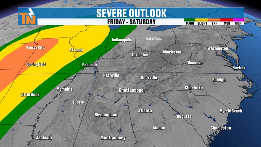

Friday: A Few Isolated Showers or Thunderstorms
As the system approaches, moisture will begin creeping northward into the Tennessee Valley.
Thanks to increasing humidity and instability, we could see:
- A few scattered afternoon showers
- Possibly a rumble of thunder
These will be isolated and not particularly impactful, but they signal the atmosphere gradually becoming more active.
Weekend Forecast: Cold Front Brings Showers and Thunderstorms
The main weather system arrives late Saturday into Sunday as a cold front pushes eastward toward East Tennessee.
Storms will be much stronger across the Mississippi Valley, but the line of storms is expected to weaken as it reaches our area.
Timeline for the Weekend System
Saturday Morning
- Mostly dry locally.
- Strong storms developing west of the Tennessee Valley.
Saturday Afternoon and Evening
- Storms continue strengthening west of Tennessee.
- Clouds increase locally.
Late Saturday Night into Sunday
- A line of showers and thunderstorms moves through East Tennessee.
- Some storms could become isolated strong storms, but widespread severe weather is not expected at this time.
Sunday Afternoon
Improving weather conditions return.n that a strong ridge of high pressure remains in control across the Southeast.
Rain gradually shifts south.
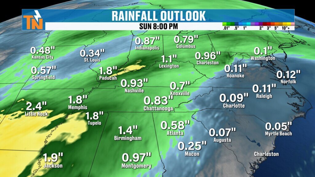
Rainfall Totals: Beneficial Rain Expected
This system will bring much-needed rainfall across East Tennessee.
Expected rainfall totals:
- Tri-Cities / Upper East Tennessee: around 0.50″
- Central Valley (Knoxville area): around 0.50–0.75″
- Southern Valley / Chattanooga region: near 0.75″
Higher elevations of the Appalachians could also see moderate rainfall.
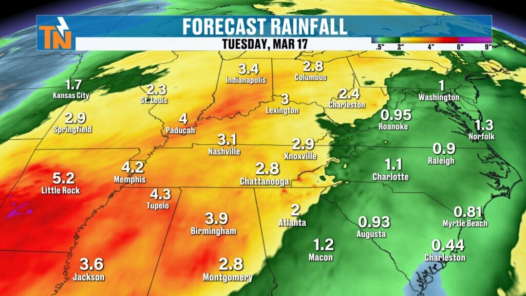
Looking Ahead: Another Storm System Next Week
The weekend system won’t be the only weather maker to watch.
Another potentially stronger storm system may arrive between March 11 and March 13.
Long-range outlooks from the Climate Prediction Center show increasing probabilities for:
- Elevated rainfall
- Additional thunderstorms
- Potentially stronger storm activity
Rainfall totals from that system could reach 1 to 2 additional inches in some areas.
Cooler Air Possible After Next Week’s System
While warmth dominates now, that mid-March system could finally push cooler air into the Tennessee Valley.
Behind that next cold front:
- Temperatures may return closer to seasonal averages.
- Cooler air currently across the Upper Midwest could push farther south.
How far south that cooler air reaches will determine how cool it gets across East Tennessee.
East Tennessee 7-Day Weather Outlook
Midweek Next Week: Watching a stronger storm system
Thursday: Near-record warmth, highs upper 70s to near 80°
Friday: Very warm with isolated showers possible
Saturday: Warm with increasing clouds, storms west of the region
Sunday: Showers and thunderstorms, improving later
Monday: Drier and slightly cooler
Tuesday: Mild with partly cloudy skies
Final Thoughts
East Tennessee is enjoying a stretch of near-record spring warmth, but an active weather pattern is developing. While this weekend’s cold front will bring beneficial rain, the stronger system arriving next week could bring heavier rainfall and a higher storm risk.
We’ll be watching that closely over the coming days.
Have a great Thursday, and thanks for checking in.