
Good morning, and happy Monday, East Tennessee!
I hope you had a great weekend.
We’ll continue the typical summertime pattern today with scattered showers and thunderstorms, especially across the higher elevations. However, the weather story quickly shifts to Tuesday night into Wednesday morning, when a stronger storm system moves through with the potential for severe weather and locally heavy rainfall.
If you haven’t already, now is the time to review your severe weather plans and make sure you have a way to receive warnings while you’re sleeping.
Quiet Today, But Not Completely Dry
Today’s weather won’t be a washout.
We’ll see another round of scattered afternoon showers and thunderstorms, but much like the past several days, many communities will remain dry while others pick up a quick downpour.
The best chance for rain today will be across:
- The Cumberland Plateau
- The Smokies
- The higher elevations of the mountain counties
A few isolated showers may drift into the Valley, but overall coverage will be much lower than what we’ll see Tuesday night.
Flooding and Isolated Strong Storms Remain Possible
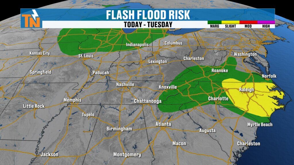
The Weather Prediction Center continues a Level 1 risk for localized flooding, mainly across the eastern half of East Tennessee where repeated rounds of rain have saturated the ground.
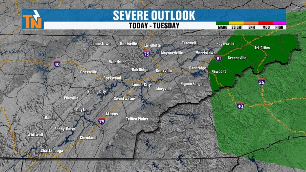
Meanwhile, the Storm Prediction Center has highlighted portions of Upper East Tennessee with a Level 1 severe weather risk, where a few isolated storms could become strong this afternoon.
Any storm that develops today will still be capable of producing:
- Locally heavy rainfall
- Frequent lightning
- Gusty winds
Hot and Humid Again
The day begins with areas of patchy dense fog before giving way to another warm and humid afternoon.
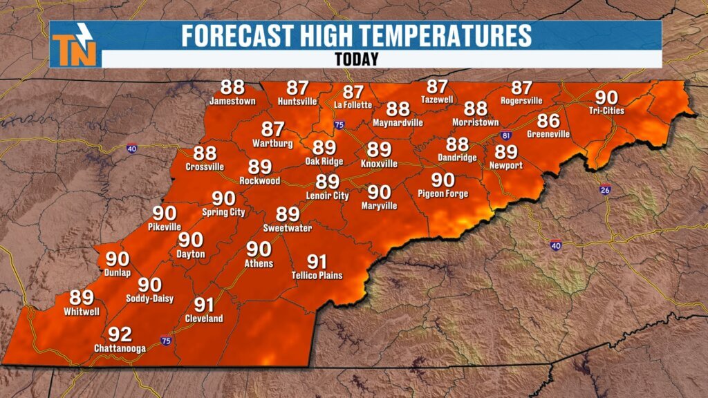
High temperatures climb into the upper 80s and near 90 degrees, which is right on schedule for late July.
Thanks to the humidity, however, it will feel much hotter.
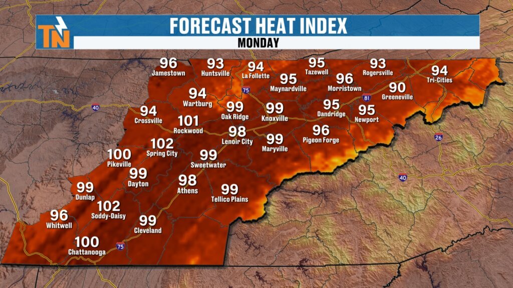
Heat index values climb into the upper 90s and lower 100s, especially across the Tennessee Valley.
The National Weather Service has even issued a Heat Advisory for portions of the northern Cumberland Plateau, including Fentress and Cumberland counties, where the combination of heat and humidity will create dangerous conditions this afternoon.
If you’re spending time outside, remember to:
- Stay hydrated
- Take frequent breaks
- Avoid strenuous activity during the hottest part of the day
Tuesday Night Is the Weather to Watch
While today brings only isolated storms, Tuesday night is a different story.
We’ve been talking about this system for several days, and confidence continues to increase that East Tennessee will see multiple rounds of thunderstorms Tuesday evening through early Wednesday morning.
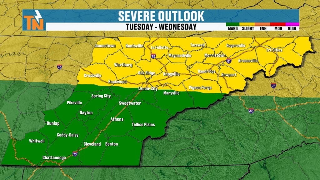
The Storm Prediction Center continues to highlight the region with:
- Level 2 (Slight) Risk north of Interstate 40
- Level 1 (Marginal) Risk south of Interstate 40
The greatest concern will arrive Tuesday evening and continue overnight into Wednesday morning, when several waves of energy move through the Tennessee Valley.
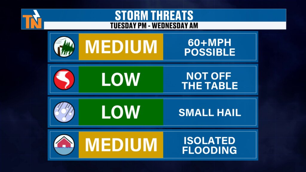
Main Storm Threats
Current forecast concerns include:
- Damaging straight-line winds (primary threat)
- Brief spin-up tornadoes
- Small hail
- Torrential rainfall
- Localized flooding and flash flooding
Because much of this event may occur overnight, it’s especially important to have multiple ways to receive weather warnings while you’re asleep.
Timing the Storms
Tuesday starts off fairly quiet with only isolated afternoon showers.
The stronger storms are expected to arrive:
- Late Tuesday evening
- Overnight Tuesday night
- Early Wednesday morning
By Wednesday afternoon, the cold front pushes east, allowing drier air to gradually move into the region.
A few lingering showers may continue across the southern Valley and mountain counties during the first half of Wednesday before skies begin clearing later in the day.
Rainfall Outlook
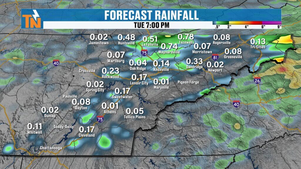
Rainfall totals through Tuesday will generally be highest north of Interstate 40.
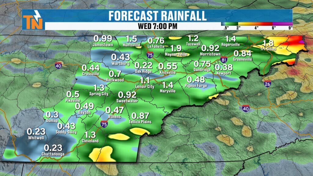
By the time the Tuesday night and Wednesday system moves through, everyone across East Tennessee has the opportunity to receive additional beneficial rainfall.
The mountain counties may once again end up with some of the highest totals.
Given how wet many areas have been recently, localized flooding will remain a concern through midweek.
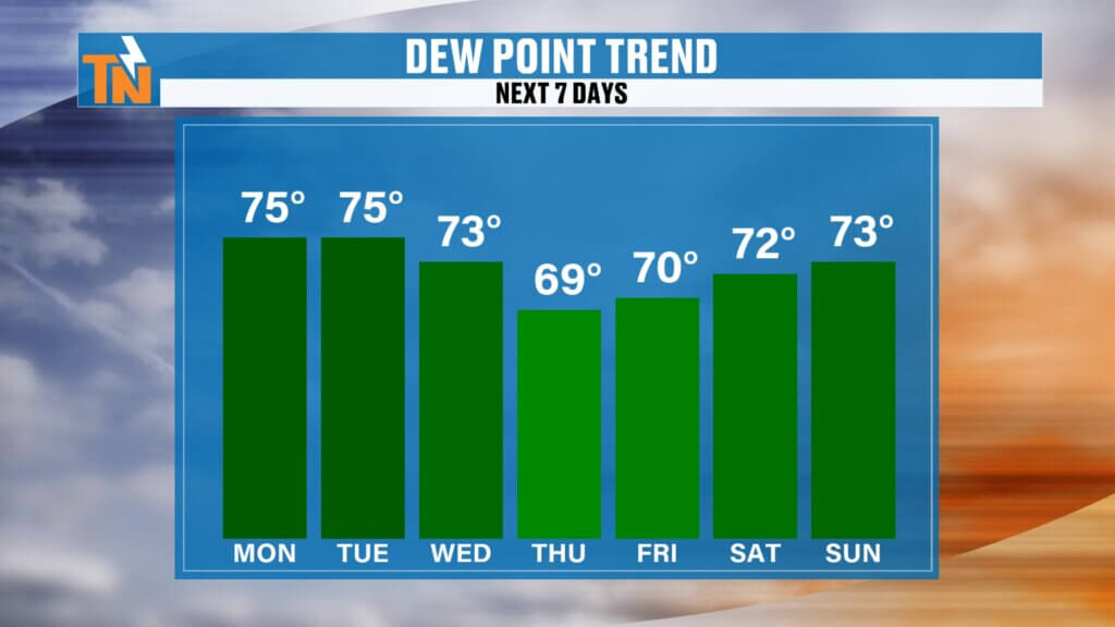
Relief Finally Arrives
The reward for getting through this next weather system arrives on Thursday.
A refreshing push of slightly drier air moves into East Tennessee, bringing:
- Lower humidity
- Lower heat index values
- Comfortable mornings
- Pleasant evenings
- Plenty of sunshine
While dew points won’t crash, they’ll fall enough to make a noticeable difference compared to the tropical air we’ve experienced recently.
Thursday is shaping up to be the nicest day of the week.
Looking Ahead
The quieter weather doesn’t last long.
Humidity begins creeping back up Friday before another northwest flow pattern develops over the weekend.
That setup will once again bring scattered afternoon showers and thunderstorms Saturday and Sunday.
Regional Forecast
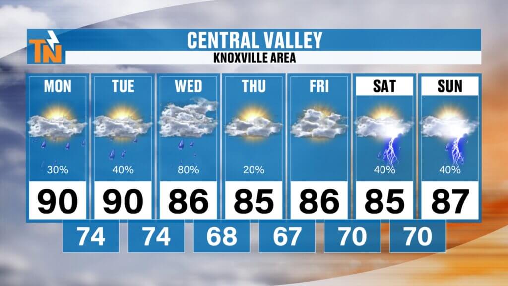
Central Valley (Knoxville)
Highs near 90° today and Tuesday, cooling into the middle 80s Wednesday through Friday. Thursday looks outstanding before rain chances return next weekend.
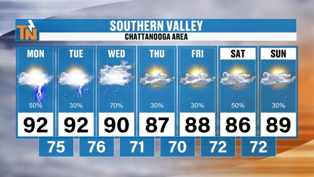
Southern Valley (Chattanooga)
Low 90s continue through Tuesday before cooler, drier air briefly arrives Thursday. Storm chances increase Tuesday night into Wednesday.
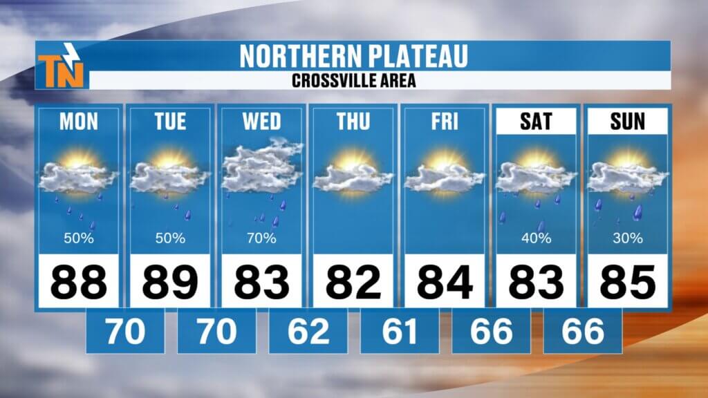
Cumberland Plateau
Near 90° today under a Heat Advisory before temperatures fall into the 80s Wednesday through Friday with noticeably lower humidity.
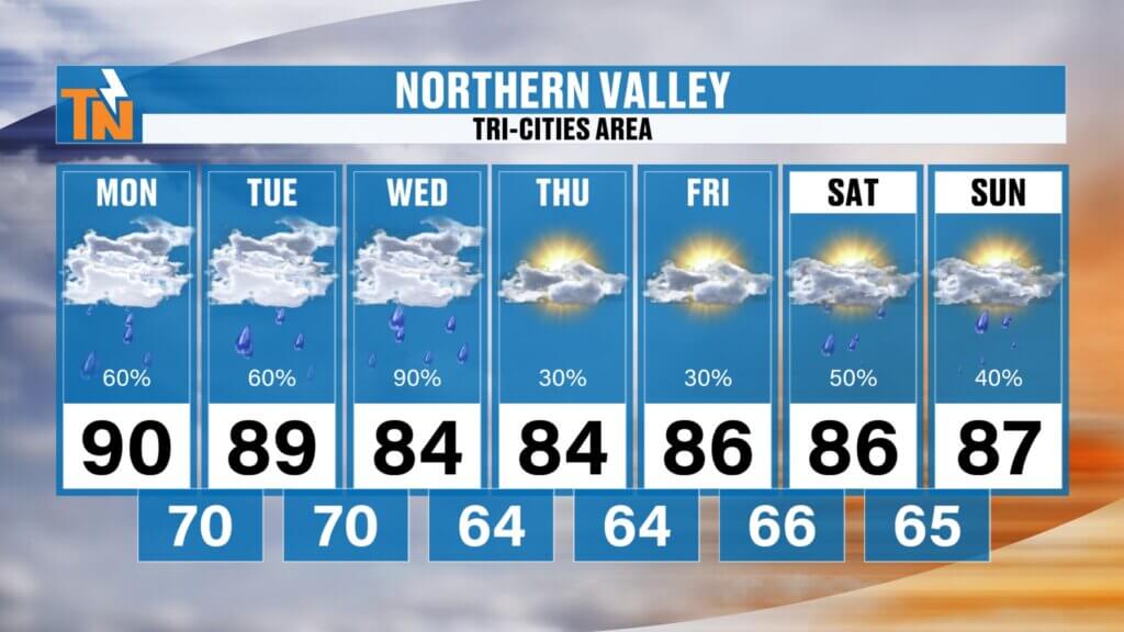
Northern Valley & Tri-Cities
Near 90° through Tuesday before cooling into the middle 80s. This area remains one of the better locations for heavier rainfall Tuesday night into Wednesday.
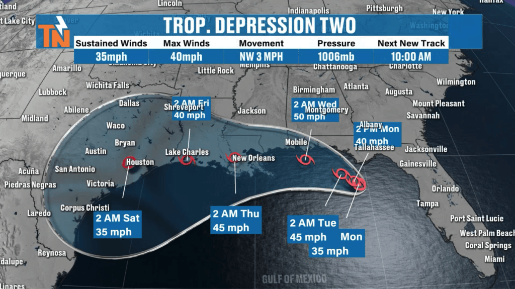
Tropical Update
Tropical Depression Two remains nearly stationary over the Gulf of Mexico.
The system is not expected to impact East Tennessee, but if you have travel plans along the Gulf Coast this week, be prepared for periods of heavy tropical rain.
I’ll continue providing updates on both the tropical system and our severe weather threat across my social media platforms.
The Bottom Line
Today features another hot and humid summer day with scattered afternoon showers and thunderstorms, mainly across the Plateau and mountain counties.
The weather becomes much more active Tuesday night into Wednesday morning as a stronger storm system moves through with the potential for damaging winds, isolated tornadoes, flooding, and heavy rainfall.
By Thursday, we’ll finally enjoy lower humidity, cooler mornings, and some of the nicest weather we’ve seen in weeks before storm chances gradually return next weekend.
Stay weather aware, make sure your weather alerts are turned on, and keep the free eastTNweather app nearby for interactive radar, lightning alerts, and the latest forecast updates throughout the week.