
Good morning and Happy Monday. Thanks for checking in with your East Tennessee morning weather update. It’s a rainy, soggy, and slow-moving start to the day after a very active overnight period across the region.
Strong storms moved through East Tennessee overnight with numerous severe thunderstorm warnings and tornado warnings along the leading edge of the cold front. Now that the front has passed, colder air is rushing in behind it, and that means snow showers will develop later today as temperatures fall.
Let’s break down what happened overnight and what to expect throughout the day.
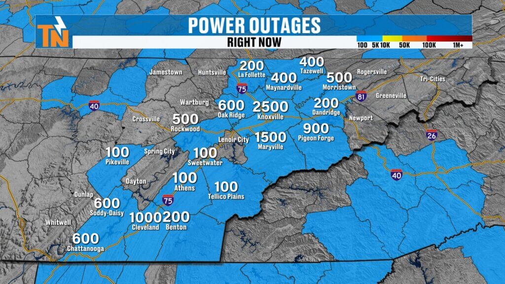
Overnight Storms Bring Heavy Rain and Power Outages
It was a stormy night across the entire Tennessee Valley as a strong cold front pushed through the region.
The storms produced:
- Multiple severe thunderstorm warnings
- Several tornado warnings along the leading edge of the storm line
- Heavy rainfall across the region
- Strong wind gusts and scattered power outages
In Knox County, more than 3,500 customers were without power early this morning as a result of the overnight storms.
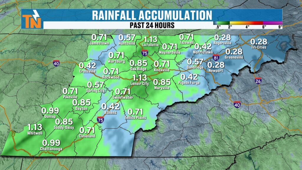
Rainfall totals across East Tennessee generally ranged between:
- 0.75 inches to over 1 inch locally
The rain is still lingering this morning but is gradually pushing eastward and beginning to exit the region.
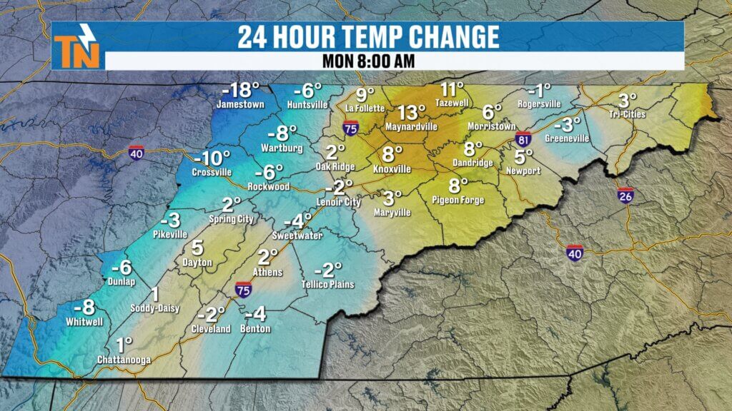
Temperatures Begin Falling as Cold Air Moves In
Behind the cold front, colder air is quickly moving into East Tennessee.
Some areas are already starting to see temperatures drop compared to yesterday morning.
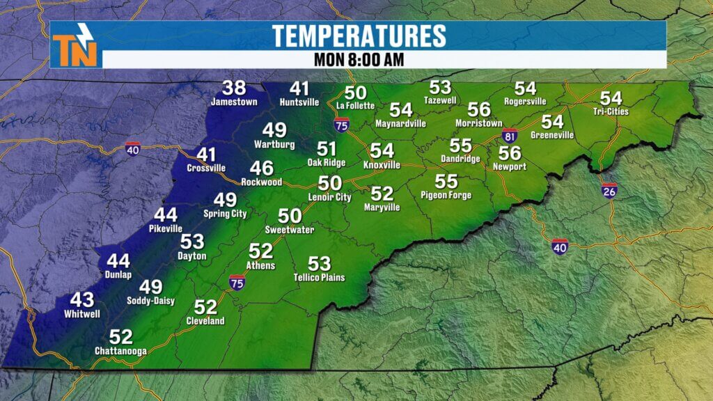
Early Morning Temperatures
- Fentress County: 47°
- Knoxville: 57°
- Tri-Cities: 55°
- Tellico Plains: 57°
Temperatures across the Cumberland Plateau are already falling, and the rest of the region will follow throughout the day.
By afternoon, many locations will see temperatures drop into the mid-30s.

Gusty Winds Create a Raw Winter Feel
Strong west to northwest winds will continue throughout the day, helping usher in colder air.
Wind speeds will range between:
- 15 to 25 mph sustained
- Higher gusts at times
Because of these winds, it will feel significantly colder.
Forecast Wind Chill Values
- Morning: Low to mid 30s
- Midday: Mid 30s to low 40s
- Afternoon: Upper 20s to mid 30s
- Evening: 20s and 30s
Overall, it will feel like a raw winter day across East Tennessee.door plans.
Rain Transitions to Snow Showers Today
As colder air continues to pour into the region, rain will transition to snow showers later today.
Snow will begin developing around midday across the Cumberland Plateau, then gradually spread across other parts of East Tennessee through the afternoon.
Snow Timeline
Late Morning
- Rain gradually ending
- Colder air arriving
Around Noon
- Snow showers developing across the Plateau
Afternoon
- Snow showers spreading across parts of East Tennessee
- Blowing snow possible with gusty winds
Evening
- Snow showers begin tapering off
Most snow activity should begin winding down by around 6 PM.
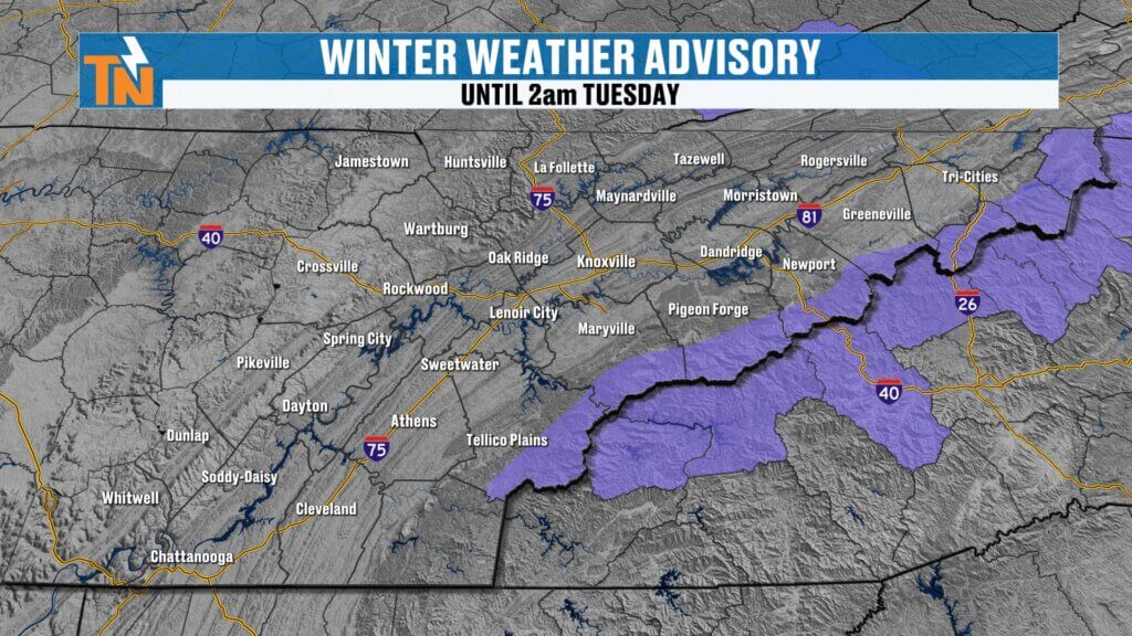
Winter Weather Advisory for the Mountains
A Winter Weather Advisory remains in effect for the mountains of East Tennessee until 2 AM tonight due to accumulating snow in higher elevations.
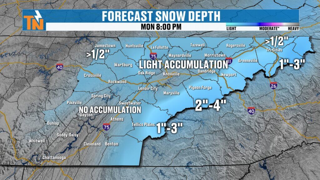
Expected Snowfall Totals
While snow will fall across much of the region, accumulations will be limited because of warm ground temperatures.
Forecast Snowfall Amounts
- South of Interstate 75: Little to no accumulation
- North of I-40 and along I-81: Light dusting possible
- Cumberland Plateau: Up to ½ inch
- Foothills: 1 to 3 inches
- Great Smoky Mountains: 2 to 4 inches
Why Roads Will Stay Mostly Wet
Despite the snow showers, travel conditions should remain manageable for most areas.
That’s because road temperatures remain well above freezing.
Forecast Road Temperatures
- Generally 40s and 50s throughout the day
After several days of 70° and even 80° temperatures last week, the ground remains too warm for widespread snow accumulation.
Most roads will simply remain wet throughout the day.
However, mountain roads may drop below freezing later this evening, so some slick spots are possible in higher elevations.
Cold Night Ahead
Once the snow showers end and skies clear tonight, temperatures will drop significantly.
Overnight lows will fall into the 20s across East Tennessee.
Warming Trend Later This Week
The cold snap will be brief.
Temperatures will begin moderating by midweek, returning to more seasonal levels.
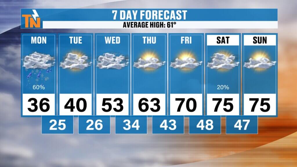
Temperature Outlook
- Monday: Temperatures falling into the mid-30s
- Tuesday: High near 40°
- Wednesday morning: Lows in the 20s
- Thursday: High near 63° (seasonal average is 61°)
Springlike Warmth Returns by the Weekend
A ridge of high pressure will build across the Southeast late this week, bringing warmer and drier conditions.
Late Week Outlook
- Friday: Mild and dry
- Saturday: Temperatures climbing into the 70s
- Sunday: Continued warm weather
The brief return of winter early this week will quickly give way to springlike temperatures once again.
East Tennessee 7-Day Forecast
- Monday: Rain changing to snow showers, falling temperatures
- Monday Night: Clearing and cold, lows in the 20s
- Tuesday: Chilly with highs near 40°
- Wednesday: Morning freeze, then milder
- Thursday: High near 63°
- Friday: Sunny and mild
- Weekend: Warming into the low to mid 70s
Final Thoughts
After a stormy night across East Tennessee, colder air is now moving in behind the cold front.
Expect snow showers and gusty winds throughout the day, making for a chilly and winter-like Monday. Fortunately, warm ground temperatures will keep most roads just wet.
The cold snap will be short-lived though, with warmer spring temperatures returning by the end of the week.
Have a great Monday and stay warm.