
Happy Saturday, East Tennessee. If you enjoyed yesterday’s sunshine, you’re going to love today. We’re looking at another beautiful, spring-like day with even slightly warmer temperatures — and this warming trend is just getting started.
Let’s break down your full weekend forecast, early week rain chances, and what the extended outlook says about above-average temperatures and potential thunderstorms.
Saturday Forecast: Sunshine, Mild Mornings, and Spring-Like Afternoon Highs
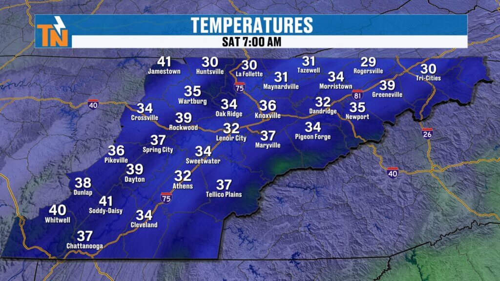
We’re starting off on the chilly side this morning, with temperatures in the 30s and 40s across much of the Tennessee Valley. Light jackets are definitely needed early on, but once the sun gets higher in the sky, temperatures will respond quickly.
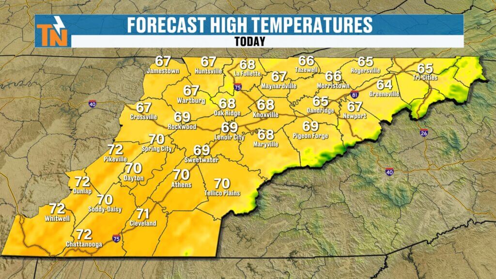
Afternoon highs:
- 65° Tri-Cities
- 68° Knoxville
- 72° Chattanooga
- 67° Crossville
Expect full sunshine from sunrise to sunset with clear skies and light winds. It’s a picture-perfect early March day across East Tennessee.
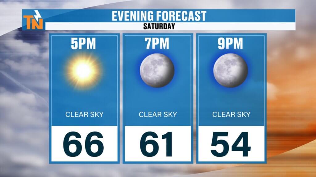
If you have evening plans:
- 66° around 5 PM
- Mid-50s by 9 PM
Clear, comfortable, and ideal for dinner plans or outdoor activities.
Weak Disturbance Tonight: More Clouds Than Rain
As we pick up the timeline around 7 PM tonight, a weak upper-level disturbance slides through the region. This system has more bark than bite.
- A few sprinkles possible along the Tennessee-Kentucky border.
- Most areas stay dry.
- Low-level atmosphere remains very dry, limiting rainfall potential.
- Increasing cloud cover overnight.
By Sunday evening, those clouds begin to exit, but the pattern remains somewhat active.
Sunday and Monday: Light Rain Returns, Cooler but Still Above Average
Sunday starts mostly dry with partly cloudy skies. However, another weak frontal boundary and upper-level wave move in late Sunday night into Monday.
Here’s what to expect:
- Late Sunday night: Increasing clouds.
- Monday: Light rain showers possible.
- Rain totals: Light overall, with better chances north and west of East Tennessee.
- Cooler air filters in Monday, but temperatures remain above seasonal averages.
This is not a major rainmaker. The bulk of meaningful precipitation continues to set up along the Tennessee-Kentucky border and farther west into the Ohio Valley.
Next Week: Drier Trend for East Tennessee, Heavier Rain Stays North
Over the past several days, forecast models had hinted at a potentially stronger, drought-busting rain event for East Tennessee. However, updated guidance shows the primary rain shield shifting farther north.
That means:
- Most heavy rainfall remains across the Ohio Valley and central/northern Great Plains.
- East Tennessee sees only scattered, light rain chances.
- Rain probabilities stay around 20% through much of the workweek.
- No widespread soaking event at this time.
This northward shift significantly reduces our rainfall totals compared to earlier projections.
Temperature Outlook: Warmer Pattern Strengthening
Even with occasional clouds and light showers, temperatures are trending impressively warm.
- Upper 60s today and Sunday.
- Slight dip Monday with cooler air behind the weak system.
- Mid to upper 60s midweek.
- Low to mid 70s late next week.
- Potential to push mid to upper 70s — possibly nearing 80° in some spots.
The Climate Prediction Center’s 6–10 day and 8–14 day outlook continues to highlight above-average temperatures across the Southeast, including East Tennessee.
This reinforces the idea that we’re transitioning into a sustained warmer pattern.
Extended Outlook: Increasing Instability and Thunderstorm Potential
As we move deeper into March, warmer air and increasing instability begin to enter the picture. While no organized severe weather is currently expected, the warmer setup will:
- Increase thunderstorm chances later in the extended period.
- Elevate overall rain probabilities beyond the 7-day forecast.
- Introduce more spring-like atmospheric dynamics.
From March 8th through March 14th, guidance suggests a more active precipitation pattern may settle closer to the Tennessee Valley.
In short: while next week looks mostly dry locally, the door is opening for a more unsettled spring pattern soon.
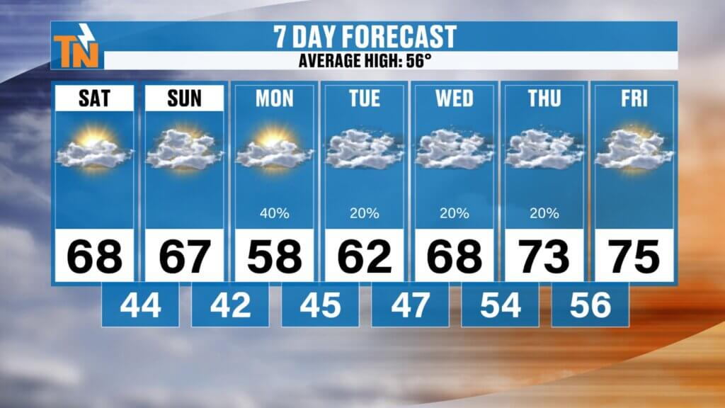
7-Day Forecast Overview
- Saturday: Sunny and near 70°.
- Sunday: Upper 60s, increasing clouds late.
- Monday: Light rain, cooler but still above average.
- Midweek: Mild with limited rain chances.
- Late week: Warming into the 70s with potential for elevated rain and thunderstorm chances beyond the 7-day window.
Final Thoughts
East Tennessee is entering a beautiful early-spring stretch. Sunshine, mild afternoons, and well-above-average temperatures dominate the weekend. While a few light rain showers are possible early next week, meaningful rainfall appears limited for now.
Keep an eye on the extended forecast, though — as warmer air builds in, so does the potential for more active spring weather.
Enjoy the sunshine today. Have a fantastic Saturday.