
Good morning and Happy Saturday.
Thanks for checking in with your East Tennessee weather update. We’re coming off a very warm and above-average Friday, with highs reaching 74 in Knoxville and 75 in Crossville. That spring warmth sticks around today, but we do have a few things to watch—especially later this afternoon.
Let’s break down what to expect as we kick off spring across the Tennessee Valley.
Warm Start with Increasing Storm Potential
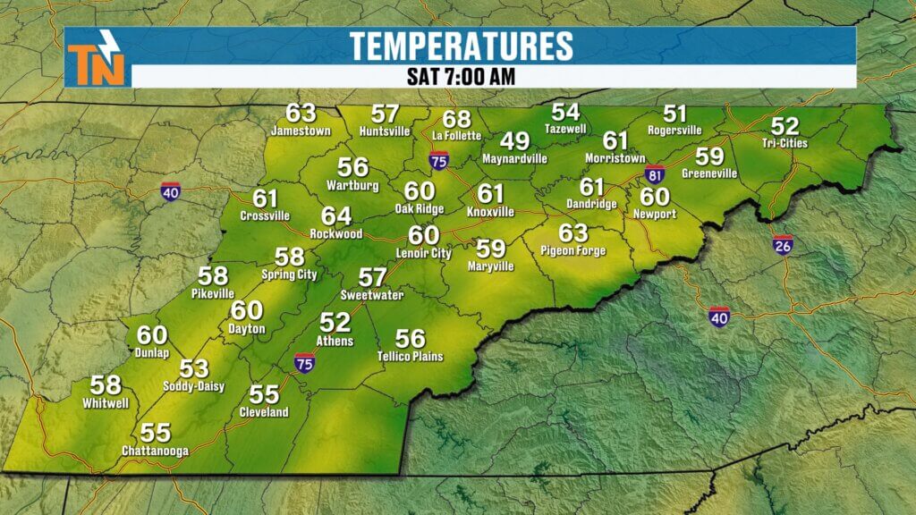
We’re starting the day off on a mild and comfortable note with temperatures in the 50s and 60s. It feels great early, and if you’ve got morning plans, you’re in good shape.
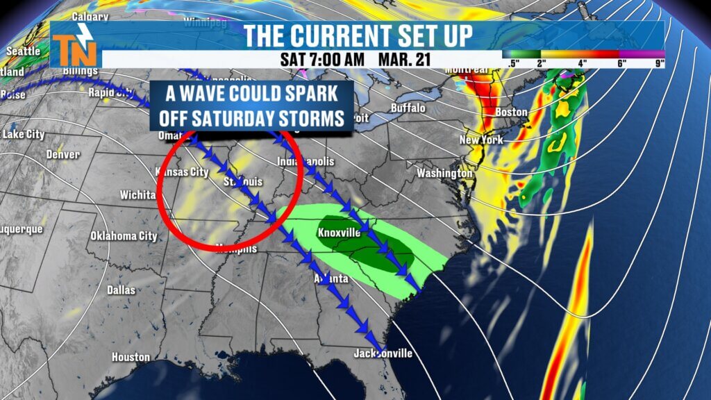
However, a disturbance moving in from the north and northwest will bring a risk for isolated thunderstorms later today.
Timing of Today’s Storms
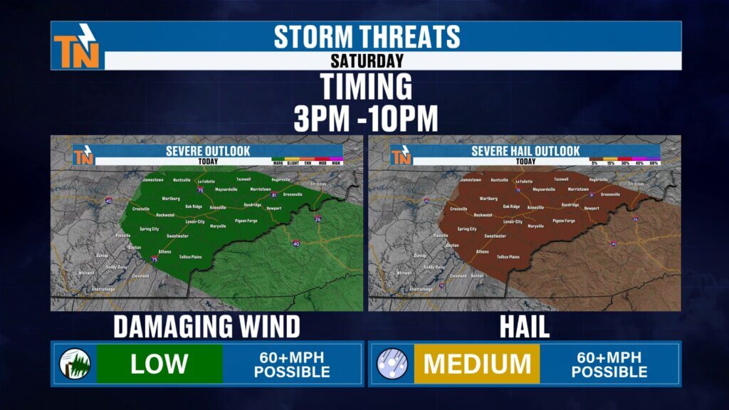
The main window to watch will be later this afternoon into the early evening.
- Storms could begin developing around 3–4 PM
- Peak timing looks to be between 5–8 PM
- Activity winds down by 9–10 PM
You’ll want to stay weather-aware during this timeframe, especially if you have outdoor plans.
Severe Weather Risk and Main Threat
The Storm Prediction Center has placed East Tennessee under a level 1 risk for severe weather, which is on the lower end—but not zero.
This setup is a little different than recent storms.
- The primary threat today is hail (around 1 inch in diameter or larger)
- Damaging winds are less likely
- Tornado risk is very low
If storms develop overhead, hail could be strong enough to cause minor damage, especially to vehicles left outside.
Why Storms Could Develop
We’ll have plenty of heat and energy building into the atmosphere today.
- Warm, muggy air will increase instability
- A weak boundary will act as a trigger
- Storm energy peaks late afternoon, then quickly fades in the evening
Once the sun goes down, we lose that energy and storms will weaken.A great night to be outdoors.
Sky Conditions and Temperature Outlook
Expect a mix of clouds and sunshine throughout the day.
- Morning: partly cloudy
- Midday: more sunshine
- Afternoon: clouds increase again ahead of storms
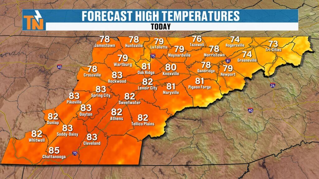
High temperatures will climb into the 70s and low 80s, making it another warm spring day.
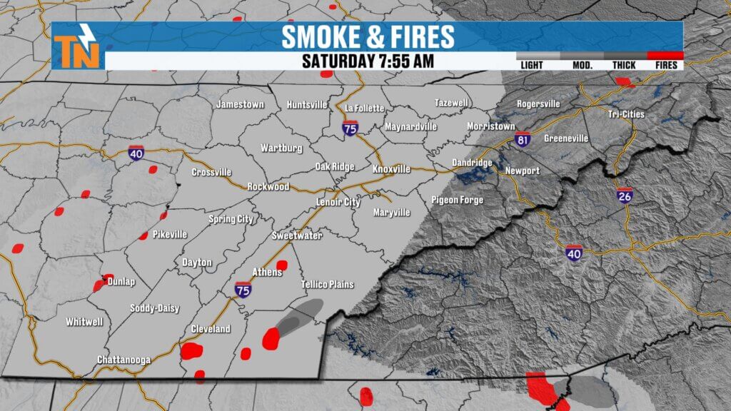
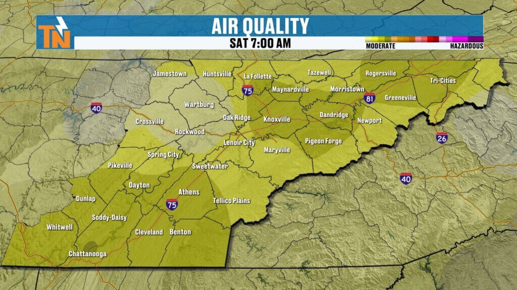
Smoke and Air Quality Concerns
You may have noticed a hazy look to the sky recently. That’s due to smoke from prescribed burns and ongoing fires in parts of the region.
- Smoke will continue to linger today
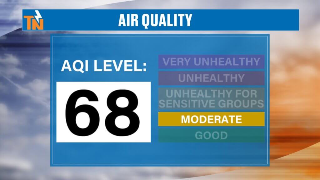
- Air quality is in the moderate category
- Those with respiratory issues may notice irritation
Areas near Tellico Plains and Bald River Falls could see thicker smoke at times.Severe weather is not expected, but it’s something to keep in mind if you have outdoor plans.
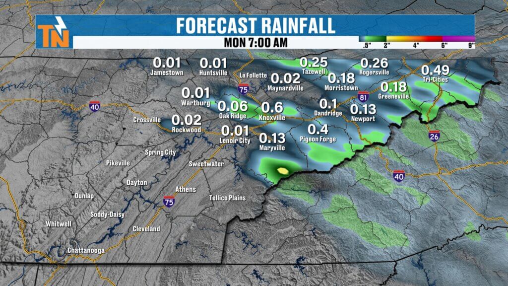
Rainfall Expectations
Rainfall today will be hit or miss.
No widespread soaking rain expected
Some areas will get brief downpours
Others may stay completely dry
Sunday Preview: Warm and Breezy
Sunday will be another warm day ahead of our next system.
- Highs in the low to mid 80s
- Breezy conditions
- Dry during the day
Clouds will increase late as the next system approaches.
Next Rain Chance: Sunday Night into Monday
A weak cold front arrives late Sunday into early Monday.
- Light rain showers overnight
- Wet roads possible for the Monday morning commute
- Rainfall totals remain low
Temperatures will begin to cool slightly behind the front..
Extended Forecast: Cooling Then Warming Again
- Monday: cooler with highs in the 60s
- Tuesday–Wednesday: seasonal and comfortable
- Thursday–Friday: warmer again with highs back into the 70s
Another system late next week could bring better rain chances.
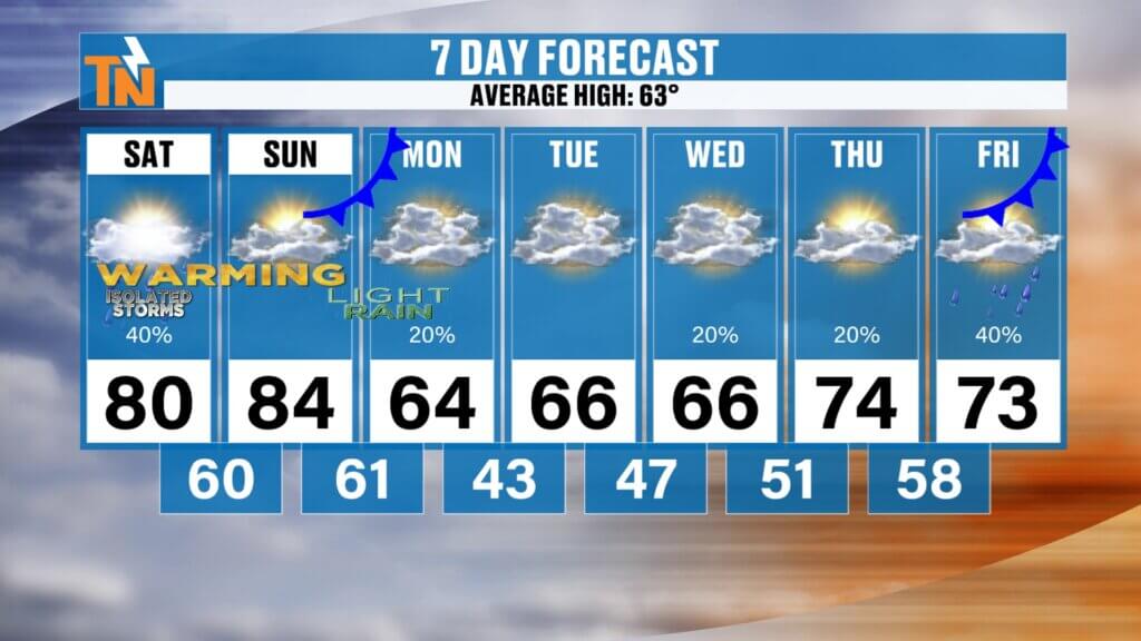
7-Day East Tennessee Outlook
- Saturday: Warm with afternoon/evening storms, highs near 80
- Sunday: Warm and breezy, highs mid 80s
- Sunday Night: Light rain develops
- Monday: Cooler with clouds and showers early
- Tuesday: Dry and seasonal
- Wednesday: Continued mild conditions
- Thursday–Friday: Warmer with increasing rain chances
Final Thoughts
Today is a classic spring setup—warm, a little muggy, and just enough energy for a few storms to pop.
Keep an eye to the northwest sky later today, especially after 3 PM. Not everyone sees storms, but if you do, hail is the main concern.
Have a great Saturday, and stay weather aware this afternoon.