
Good morning and Happy Friday.
Thanks for checking in with your East Tennessee morning weather update. After a chilly start to the day, we’re looking at a beautiful but breezy Friday with temperatures warming nicely this afternoon. The upcoming weekend will bring spring-like warmth and sunshine, but a stronger storm system will move in late Sunday night into Monday bringing rain, gusty winds, and even the possibility of a few light snow showers behind the cold front.
Let’s break down the forecast for the Tennessee Valley.
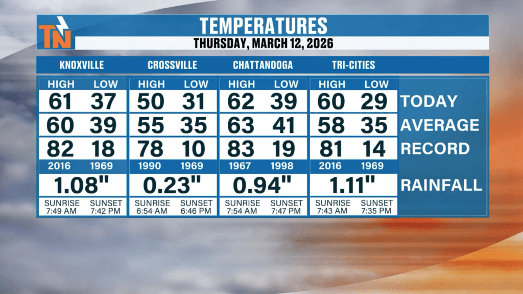
A Deceptively Cool Day Yesterday
Yesterday’s weather may have looked warm on paper, but it certainly didn’t feel that way.
The official high temperature of 61° actually occurred just after midnight at 12:40 AM, meaning most of the day felt much cooler as colder air filtered into the region behind the previous system.
Today will be different, as sunshine and a strong southwest wind will help temperatures rebound this afternoon.
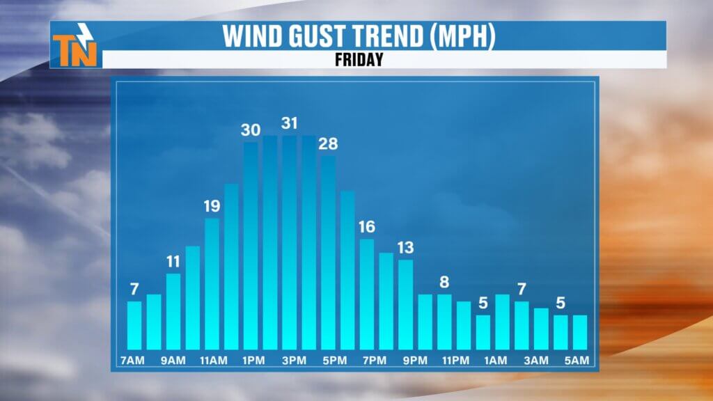
Windy Conditions Today Across East Tennessee
A developing weather system moving through the Ohio Valley combined with high pressure to our south and southeast is creating a tight pressure gradient across the region.
This setup will produce gusty winds across East Tennessee throughout the day.
Expected Wind Conditions
- Southwest winds gusting 30 to 35 mph
- Strongest winds across Kentucky, Ohio, and the Great Lakes
- Breezy but manageable conditions across the Tennessee Valley
If you’re traveling north on Interstate 75 toward Kentucky, you’ll likely encounter stronger winds as you head farther north.
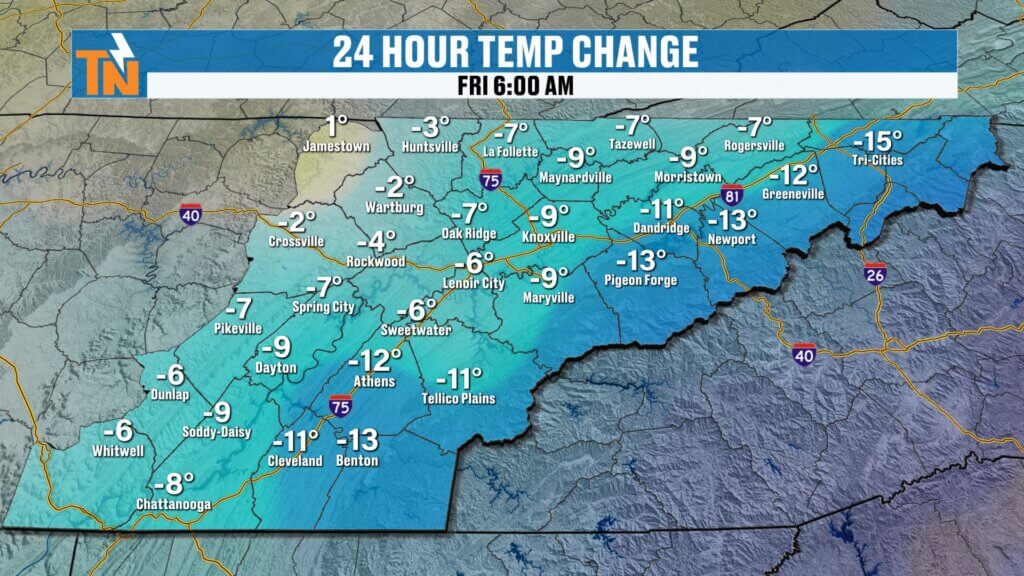
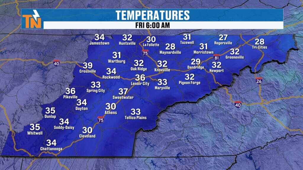
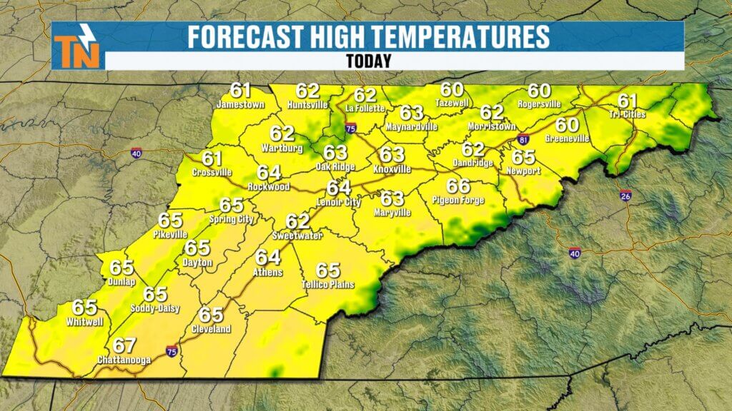
Temperatures Rebound This Afternoon
Despite a chilly start this morning, temperatures will climb quickly thanks to the strong southwest flow bringing warmer air back into the region.
Many locations started the morning in the 20s and 30s, including:
- Lenoir City: around 37°
- Other valley locations in the low to mid 30s
By this afternoon, highs will reach the low to mid 60s across East Tennessee.
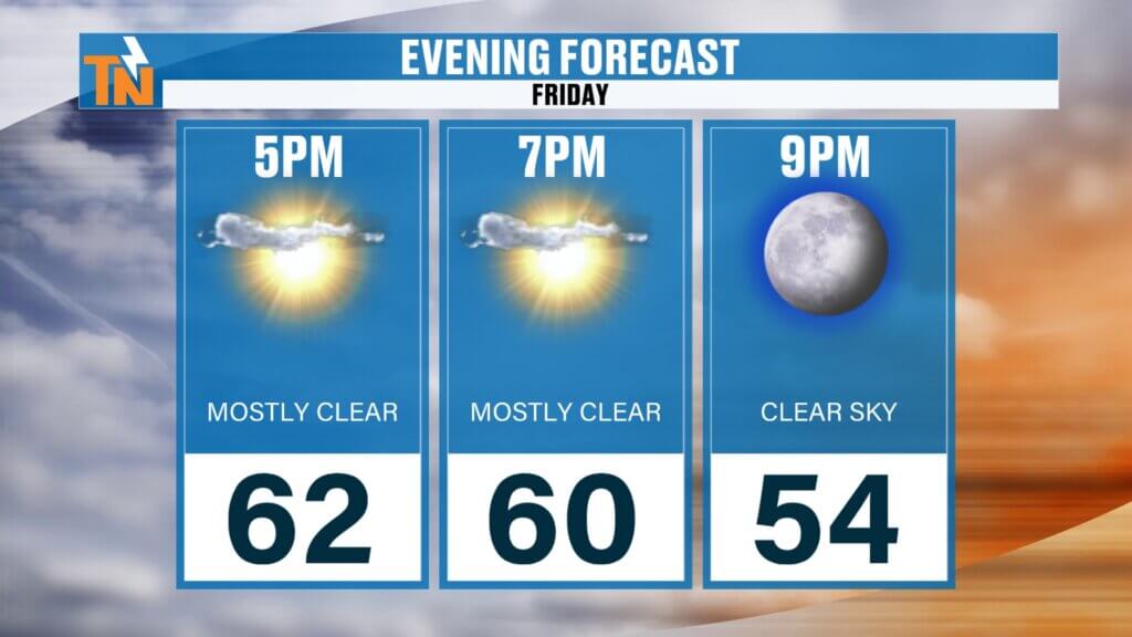
Friday Evening Forecast
If you have evening plans, conditions will remain pleasant.
The winds will gradually begin to relax after sunset.
Evening Temperatures
- 7 PM: around 60°
- 9 PM: near 54°
Overall, it should be a comfortable night to get outside.
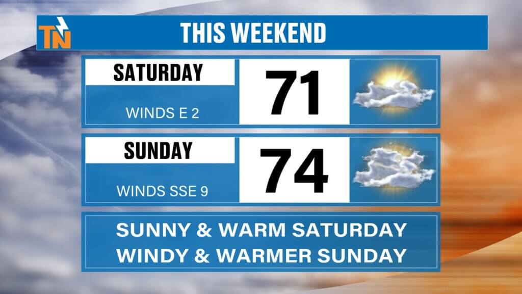
Warm Spring-Like Weekend Ahead
The weekend forecast looks fantastic for outdoor activities across East Tennessee.
High pressure will keep conditions mostly dry while warm air continues flowing into the Tennessee Valley.
Weekend High Temperatures
- Saturday: low to mid 70s with sunshine
- Sunday: low to mid 70s with increasing clouds
Saturday will likely be the best outdoor day of the weekend with sunshine and light winds.
Clouds and Winds Increase Sunday
By Sunday, the next weather system begins approaching from the west.
You’ll notice:
- Increasing cloud cover
- Stronger winds
- Continued warm temperatures
Even though Sunday will remain warm and mostly dry during the day, conditions will begin to change by Sunday night.
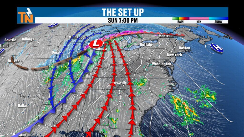
Sunday Night Cold Front Brings Rain and Storms
A deep trough moving out of the Plains into the Mississippi Valley will push a cold front toward the Southeast late Sunday night.
This system will strengthen as it approaches, bringing showers and thunderstorms into East Tennessee overnight Sunday into early Monday morning.
Timeline for the Next Storm System
Sunday Evening
- Increasing clouds
- Breezy conditions
- Still warm
Late Sunday Night
- Cold front approaches from the west
- Rain showers developing
Early Monday Morning
- Widespread rain and possible thunderstorms
Most of the rain will occur during the Monday morning timeframe.
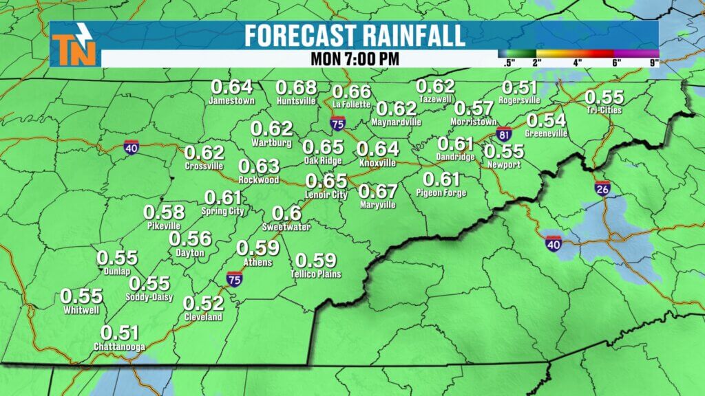
Rainfall Totals from the Next System
This system should bring around a half inch of rainfall across the region, though some areas could see slightly higher totals.
While this rainfall will be beneficial, flooding concerns are not expected at this time.
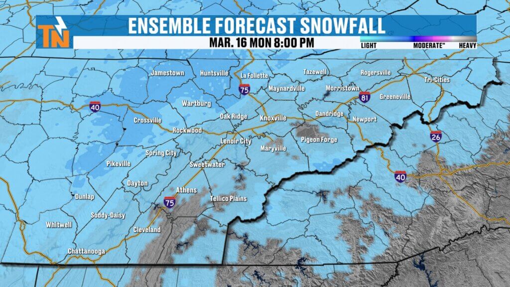
Light Snow Possible in Higher Elevations
As colder air arrives, some light snow showers could develop Monday, especially across:
- The Cumberland Plateau
- The Smoky Mountains
- Higher elevations of East Tennessee
Ground temperatures remain relatively warm, so travel issues are not expected.
Colder Air Arrives Monday
Behind the cold front, a significantly colder air mass will move into the Tennessee Valley.
Temperatures Monday will likely fall throughout the day, rather than rise.
Monday Temperature Trend
- Morning: temperatures in the 40s and low 50s
- Afternoon: falling into the 30s
Wind chills may drop into the 20s by Monday afternoon.
Cooler Start to Next Week
Tuesday will likely be the coldest day following the front, with temperatures remaining below average.
However, temperatures should begin moderating again by midweek.
Midweek Outlook
- Tuesday: cold with highs in the 40s
- Wednesday: warming back into the 50s
- Thursday: milder conditions returning
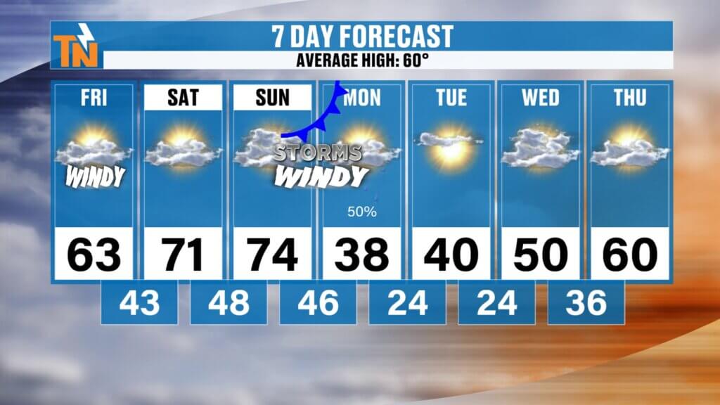
East Tennessee 7-Day Weather Outlook
- Friday: Windy with sunshine, high near 63°
- Saturday: Sunny and warm, highs in the low to mid 70s
- Sunday: Increasing clouds and breezy
- Sunday Night – Monday: Rain and thunderstorms possible
- Monday: Falling temperatures with light snow possible in higher elevations
- Tuesday: Cold with highs in the 40s
- Wednesday – Thursday: Gradual warming trend returns
Final Thoughts
East Tennessee will enjoy a beautiful but breezy Friday followed by a warm weekend, but a strong cold front arriving late Sunday night will bring rain, gusty winds, and much colder temperatures early next week.
Some areas may even see a few light snow showers Monday as colder air settles into the region.
Have a great Friday, enjoy the sunshine today, and we’ll see you back here for the next update.