
Happy Monday and thanks for checking in with your East Tennessee morning weather update. We have a lot to talk about today, starting with dense fog this morning, warmer temperatures this afternoon, and two upcoming storm systems that could bring rain and thunderstorms to the region.
While tonight’s system will mainly bring scattered showers, the bigger weather maker arrives late Wednesday into early Thursday, when a strong cold front could trigger isolated strong to severe thunderstorms across parts of East Tennessee.
Let’s walk through the forecast step by step
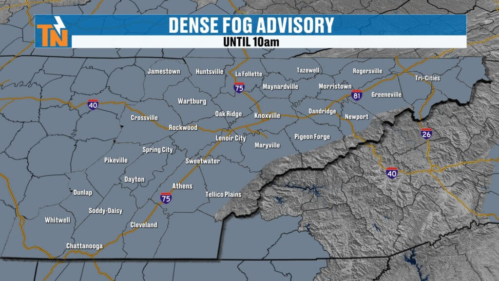

Dense Fog Advisory This Morning Across East Tennessee
The day is starting off with thick fog across much of the Tennessee Valley, and a Dense Fog Advisory remains in effect until 10 AM.
Visibility has been reduced in several locations, so if you’re heading out early this morning, be prepared for:
- Reduced visibility on area roadways
- Slow travel conditions during the morning commute
- Fog lingering through the mid-morning hours
As we head into the late morning hours around 10 to 11 AM, the fog will begin to lift and gradually dissipate. Typically, fog lifts into a low cloud deck first before sunshine fully returns.
By late morning into the early afternoon, skies should begin clearing with some sunshine returning across East Tennessee.
Warm Temperatures Return This Afternoon
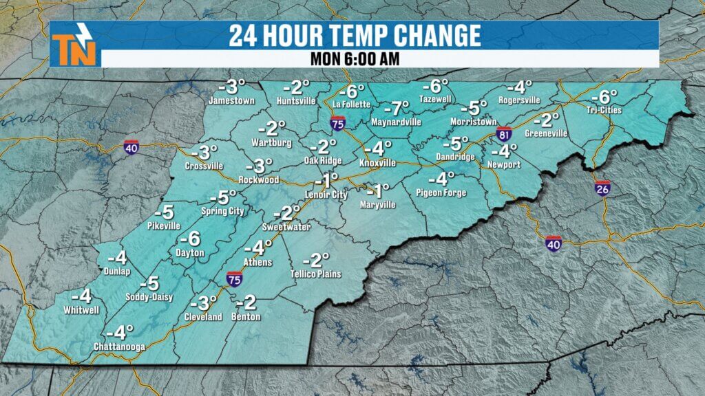
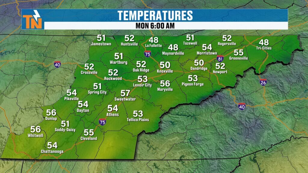
Despite the foggy start, temperatures will warm quickly today.
Morning temperatures are already sitting in the 50s across much of the region, which is well above the seasonal average for early March.
With partial sunshine this afternoon, expect high temperatures climbing into the mid to upper 70s across East Tennessee.
That puts us close to near-record warmth once again as spring-like weather continues across the Tennessee Valley.
Tonight’s Weather: Scattered Showers Overnight
A small disturbance moving through the atmosphere will bring scattered showers overnight tonight.
Rain chances will begin increasing after sunset, particularly across the southern portions of East Tennessee south of Interstate 40.
Timeline for Overnight Rain
- 6–7 PM: Isolated showers possible south of I-40
- Late Evening: Scattered rain develops across more of the region
- 2–4 AM Tuesday: Additional showers and a few rumbles of thunder possible
Instability with this system will be limited, so severe weather is not expected tonight.
Rainfall totals will generally be light, and not every location will receive measurable rainfall.
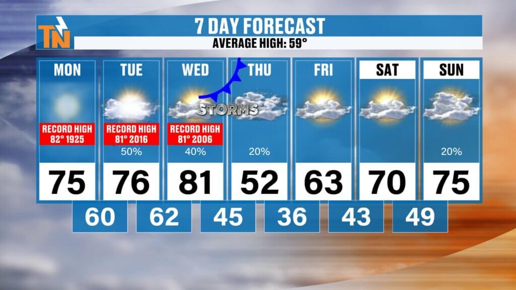
Tuesday and Wednesday: Unsettled but Warm
The weather pattern remains somewhat unsettled through midweek as additional energy moves through the atmosphere.
Expect:
- Periodic clouds and sunshine
- Occasional light showers possible
- Continued warm temperatures
High temperatures Tuesday and Wednesday will remain well above average, with highs continuing in the 70s and possibly near 80 degrees.

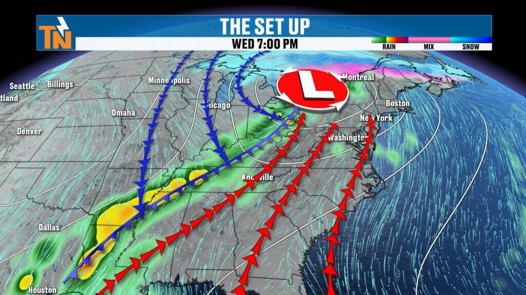
Strong Storm System Arrives Wednesday Night
The more significant weather system arrives late Wednesday into early Thursday.
This system originates from a developing trough near Baja California, which will merge with energy moving across the Plains. As it strengthens, a line of showers and thunderstorms will develop ahead of the cold front.
Current forecast models show the strongest jet stream energy staying slightly north of East Tennessee, which may limit the severe weather potential locally.
However, the setup still supports some strong storms in the region.
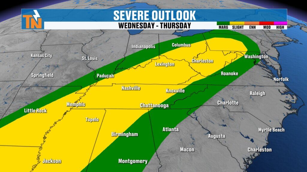
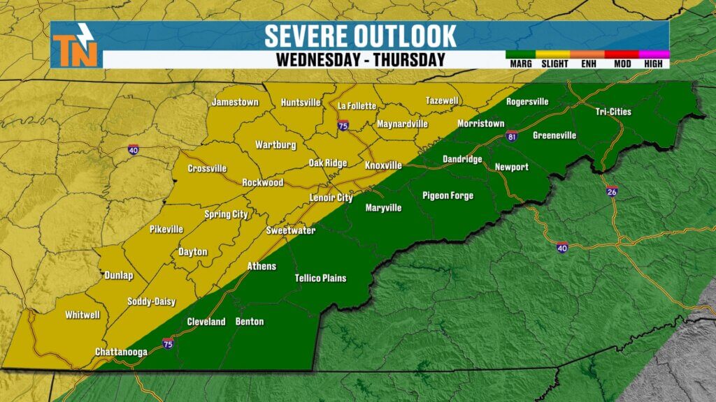
Severe Weather Risk for Wednesday Night
The Storm Prediction Center has issued a severe weather outlook for late Wednesday into early Thursday.
Current risk levels include:
- Level 2 risk (Slight Risk) for the western half of East Tennessee
- Level 1 risk (Marginal Risk) for the eastern half of the region
Storms will likely weaken somewhat as they move east into the mountains, but a few stronger storms could still occur across the Tennessee Valley.
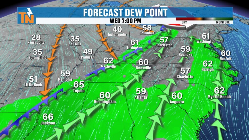
Atmospheric Setup for Midweek Storms
Ahead of the cold front, the atmosphere will become more favorable for thunderstorms.
Key ingredients include:
- Dew points climbing into the low 60s, providing moisture
- A strong push of warm air ahead of the cold front
- Increasing wind energy with the approaching trough
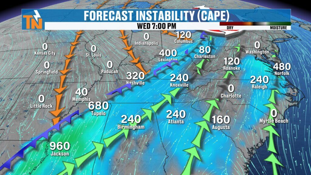
One limiting factor is relatively low atmospheric instability, which may reduce the overall severity of storms. Still, the system will be moving quickly and could produce strong wind gusts and heavy rainfall in isolated storms.
Big Temperature Drop Late Week
Once the cold front moves through early Thursday morning, the weather pattern will change quickly.
Temperatures will drop significantly as cold, dry air moves into the Tennessee Valley.
Temperature Trend
- Wednesday: Highs near 80° possible
- Thursday Morning: Temperatures in the mid 40s
- Thursday Afternoon: Highs only near the low 50s
This will be a noticeable change after several days of spring-like warmth.
Sunshine Returns and Temperatures Rebound
The cooler weather won’t last long.
By Friday and into next weekend, high pressure returns and temperatures begin warming again.
Late Week Outlook
- Friday: Mostly sunny, highs near 63°
- Saturday and Sunday: Temperatures rebound into the low to mid 70s
So while midweek brings a quick cool-down, the warm pattern quickly returns.
East Tennessee 7-Day Weather Outlook
- Monday: Morning fog, warm afternoon with highs in the 70s
- Monday Night: Scattered showers developing
- Tuesday: Warm with clouds and occasional showers
- Wednesday: Near-record warmth possible
- Wednesday Night: Strong storms possible with a cold front
- Thursday: Cooler with sunshine returning
- Friday: Mild with temperatures climbing back into the 60s
Stay Weather Aware This Week
With storms expected late Wednesday into early Thursday, it’s important to stay weather aware as the system approaches.
The East Tennessee Weather App is a great tool for staying informed with:
- Severe weather alerts
- Lightning notifications
- Interactive radar
- Watches and warnings from the National Weather Service
You can download the app by searching East Tennessee Weather in your app store.
Thanks again for checking in this morning. Stay safe in the fog early today, enjoy the warm temperatures this afternoon, and be sure to keep an eye on the midweek storm system.
Have a great Monday.