
Good morning and Happy Monday.
Thanks for checking in. Another beautiful day is ahead, but you’ll start to notice a shift—more humidity, slightly warmer temperatures, and a pattern that turns more active as we head through the week.

Warmer Start with Increasing Humidity
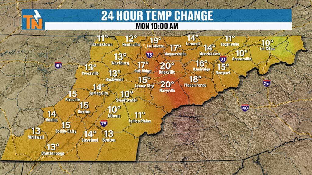
We’re starting the day noticeably milder than yesterday.
- Morning temperatures in the 50s and low 60s
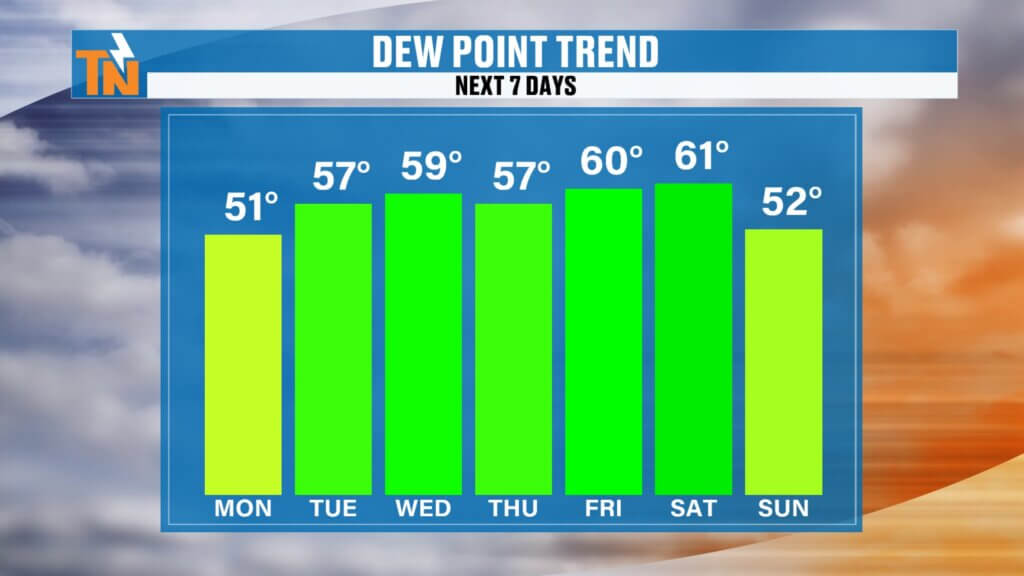
- Dew points climbing into the 40s
- Less dry air across the region
That added moisture is good news, helping to reduce the elevated fire danger we’ve been dealing with.
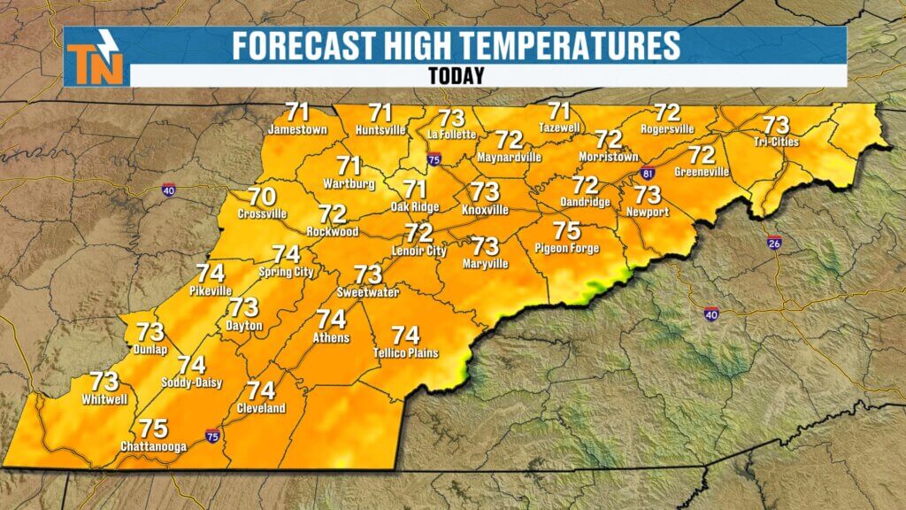
Breezy and Pleasant Monday
It’s shaping up to be another great spring day.
- Highs in the 70s
- Breezy winds gusting 20 to 25 mph
- Slightly more humid than the weekend
If you have plans this evening, conditions remain comfortable:
Mild and pleasant through the evening hoursRight around average for this time of year and great for outdoor plans.Overall, right where we should be for this time of year.
Around 72 degrees by 7 PM
Fire Danger Eases with Moisture Return
The increase in humidity plays an important role.
- Higher dew points reduce wildfire risk
- Winds remain breezy, but less concerning
- Overall safer conditions compared to recent days
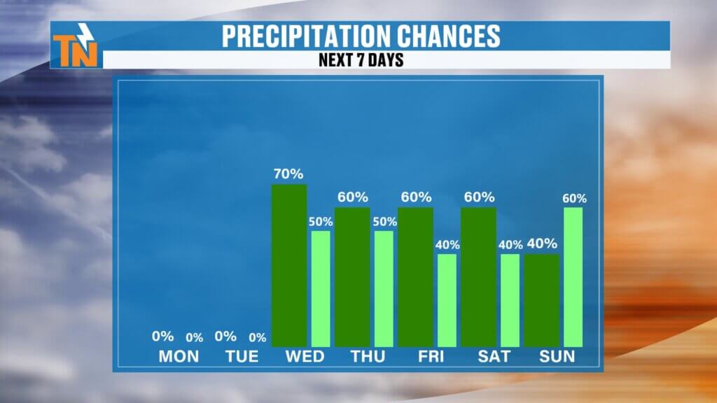
Pattern Change Begins: Rain Chances Increase
We’re transitioning into a more active weather pattern.
- Moisture continues increasing from the Gulf
- Multiple disturbances moving into the region
- Rain chances begin to ramp up midweek
You may even notice a few isolated showers or a rumble of thunder as early as Tuesday.
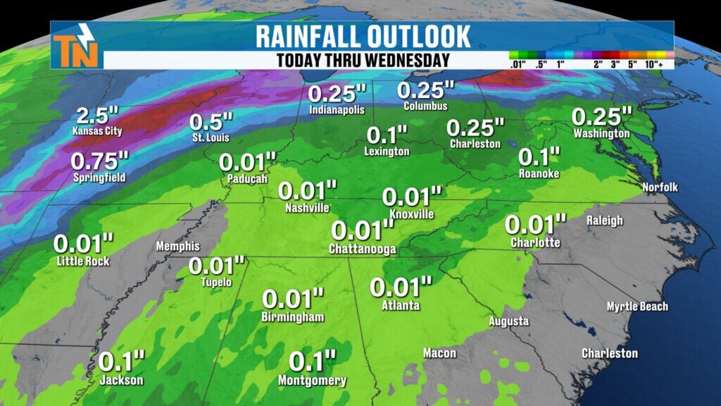
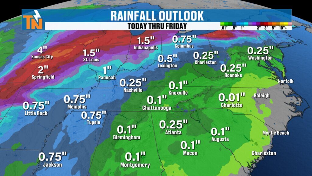
Midweek Through Friday: Scattered Showers and Storms
The better chances for rain arrive later in the week.
- Wednesday through Friday: increasing coverage of showers
- A few thunderstorms possible
- Rain not constant, but more frequent
Most of the heavier rainfall still looks to stay north and west of East Tennessee through this period.
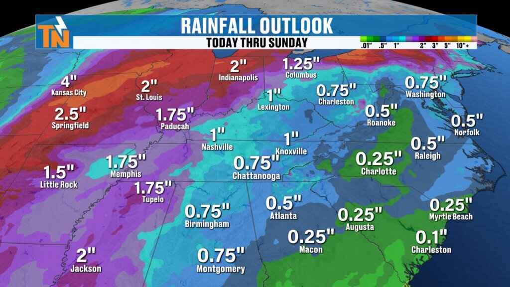
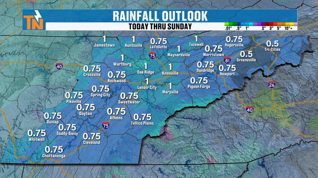
Easter Weekend Outlook
Looking ahead to the holiday weekend:
- Continued chances for rain Saturday and Sunday
- Some showers possible early Easter Sunday
- Timing still uncertain, so check back for updates
This could impact early morning plans, including sunrise services.
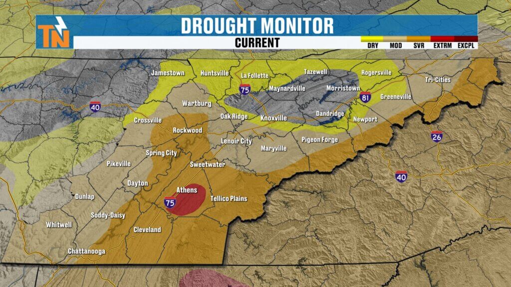
Rainfall Outlook: Helpful for Drought Conditions
Rainfall totals are trending upward, especially into the weekend.
- Limited rain through Friday
- Up to around 1 inch possible by Saturday and Sunday
- Heavier totals north and west, but still beneficial locally
This is welcome news given the ongoing drought and dry March.
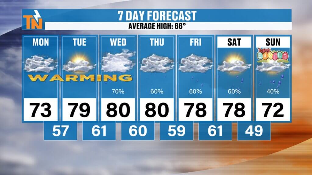
Temperature Outlook
Temperatures remain warm and spring-like.
- Highs in the 70s to low 80s through Friday
- Overnight lows in the 50s and 60s
- Slight cooldown by Easter weekend (upper 60s to low 70s)
Final Thoughts
Enjoy another warm and pleasant day today with a bit more humidity in the air. The bigger story is the shift toward a wetter pattern, which could bring some much-needed rain as we head toward Easter weekend.
Have a great Monday, and be sure to check back in for updates as the forecast continues to evolve.