
Good Morning, East Tennessee
Happy Tuesday, everybody!
After a few strong thunderstorms rolled through parts of East Tennessee yesterday, today brings a much different setup. While we can’t completely rule out a few afternoon showers or thunderstorms, many communities will stay dry as cooler and less humid air continues to settle into the region.
The biggest story this week won’t be the rain. It will be the unusually comfortable weather for early June.
What’s driving the weather today?
What’s Driving Today’s Forecast?
A strong upper-level disturbance is swinging through the Tennessee Valley today.
While we’ve lost much of the deep moisture that fueled recent storms, there’s still enough instability and atmospheric lift to generate a few scattered showers and thunderstorms during the afternoon and early evening hours.
The difference today is that any storms that develop won’t have as much moisture to work with. That means we’re not expecting widespread heavy rain or “gully washer” downpours like we’ve seen recently.At this time, damaging straight-line winds appear to be the greatest concern.
Afternoon Storm Chances
Most of the day will be quiet.
Forecast timeline:
- Morning through lunchtime: Dry with a mix of sun and clouds
- Early afternoon: Clouds begin to build
- Mid to late afternoon: Isolated showers and thunderstorms develop
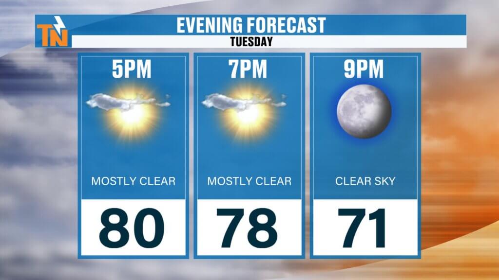
- Evening: Storm activity fades quickly
Any storms that form could produce:
- Small hail
- Gusty winds up to 40-45 mph
- Frequent lightning
- Brief downpours
A few stronger cells could trigger Special Weather Statements, but widespread severe weather is not expected.
Comfortable Air Returns
One of the best parts of today’s forecast is the humidity.
Morning dew points have fallen into the 50s and lower 60s, making it feel much more comfortable outside compared to recent days. Some patchy fog developed this morning, especially across the Southern Valley, but that will quickly burn off after sunrise.
Even better, this pleasant air mass isn’t going anywhere anytime soon.
Breezy and Mild
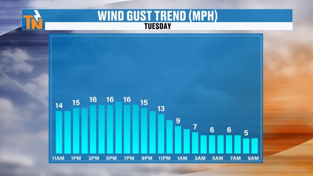
Winds will be a bit stronger today than what we’ve experienced recently.
Expect:
- Sustained winds around 10-15 mph
- Occasional gusts between 20 and 25 mph
These winds are not related to thunderstorms but are simply part of the overall weather pattern moving through the region.
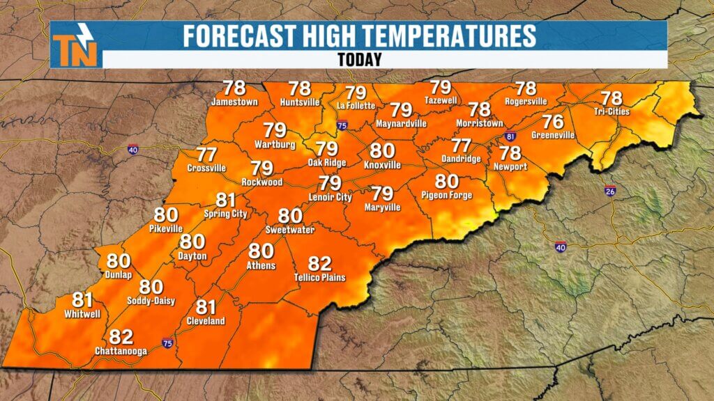
High temperatures will reach the upper 70s to lower 80s, which is very close to seasonal averages for early June.
A Fantastic Stretch of Weather Ahead
Once today’s isolated storm chances fade away, East Tennessee settles into several days of sunshine and comfortable conditions.
Wednesday through Saturday looks excellent with:
- Lower humidity
- Mostly sunny skies
- Pleasant mornings
- Warm afternoons
- Minimal rain chances
For early June, dew points this low are a real treat, so enjoy it while it lasts.
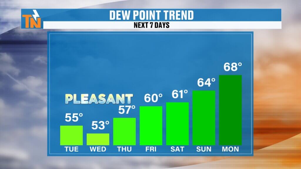
When Does Humidity Return?
The more typical summertime feel begins creeping back into the forecast late this weekend.
By Sunday and Monday:
- Dew points climb back into the upper 60s and lower 70s
- Humidity increases noticeably
- Afternoon shower and thunderstorm chances return
That’s a much more familiar East Tennessee summer pattern.
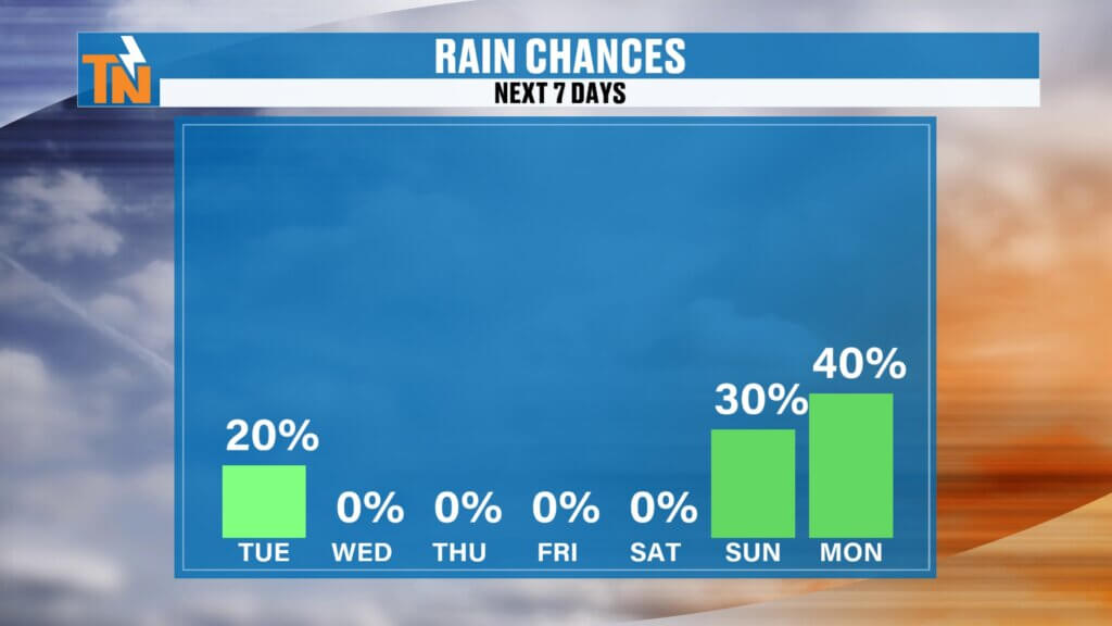
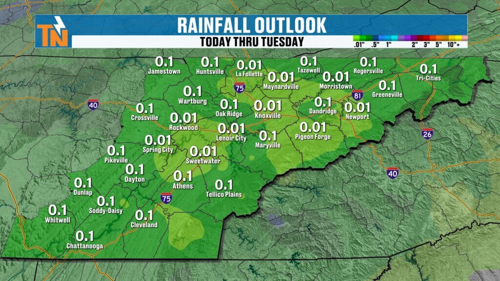
Rainfall Outlook
Rainfall chances remain very limited for the rest of the workweek.
While drought conditions still exist across portions of East Tennessee and many areas remain below average on rainfall for the year, the next several days will be relatively dry.
The next meaningful opportunity for scattered showers and thunderstorms arrives Sunday into Monday.
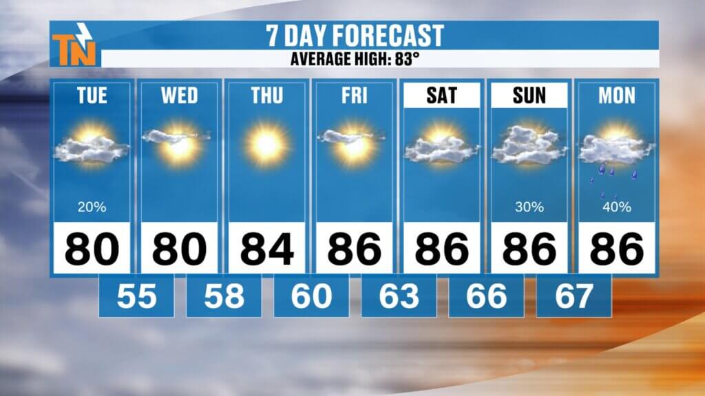
7-Day Forecast Highlights
- Tuesday: Isolated afternoon storms, highs near 80
- Wednesday: Sunny and comfortable
- Thursday: Dry with low humidity
- Friday: Warmer, highs in the mid 80s
- Saturday: Mostly sunny and warm
- Sunday: Humidity increases, isolated storms return
- Monday: More summer-like with scattered storm chances
The Bottom Line
A few isolated showers and thunderstorms are possible this afternoon, with some producing gusty winds and small hail. After that, East Tennessee settles into one of the nicest stretches of weather we’ve seen in weeks, with lower humidity, comfortable temperatures, and plenty of sunshine through Saturday.
Enjoy it now, because summer humidity starts making a comeback by the end of the weekend.shed out of the region, bringing some of the most pleasant weather we’ve seen in weeks.