
Happy Friday, everybody.
Thanks for checking in this morning.
We’re wrapping up the work week on a warm note, but changes are coming.
The heat continues to build.
Storm chances increase through the weekend.
And next week?
We’re talking about some of the hottest weather of the season so far.
Let’s break it all down.
Warm and More Humid Start to Friday
Yesterday turned out to be another nice summer day across East Tennessee.
We finished just 2 degrees below average, but that changes quickly as we head into the weekend.
This morning, temperatures are starting off warmer than yesterday by about 6 to 7 degrees.
Most of us are waking up in the 60s.
Humidity is also climbing.
And you can feel it.
That sticky summer air is starting to settle back in.
Out west, showers and thunderstorms are already developing.
To our north, a frontal boundary is slowly sagging southward.
That front will be the focus for our storm chances through the weekend.
Friday Forecast: Mostly Dry, But Watching the North
Through lunchtime today, we stay dry.
A few clouds will hang around, but overall it’s another decent day.
By this afternoon, however, we’ll begin watching a disturbance sliding in from the north.
Most of the stronger storm activity should stay north of us.
But:
A few isolated showers and thunderstorms could pop up, especially across:
- Cumberland Plateau
- Northern Valley locations
- Areas north of Interstate 40
- East Tennessee mountain communities
Rain coverage today remains limited.
Only around a 20% chance.
But if you have outdoor plans tonight, just check the radar.
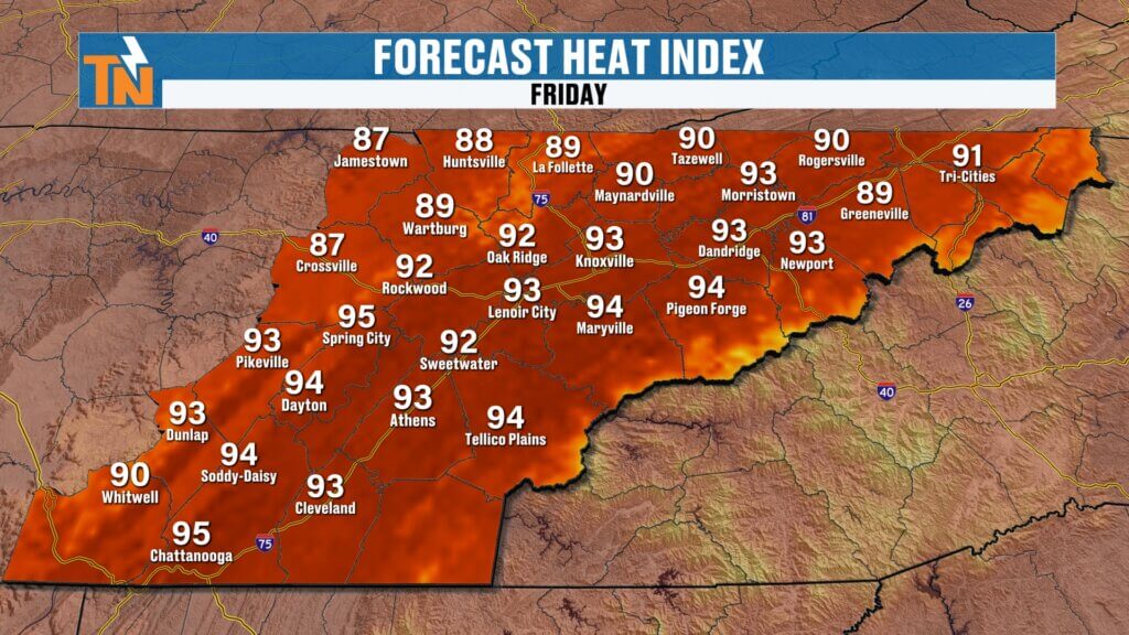
Heat Index Values Start Climbing
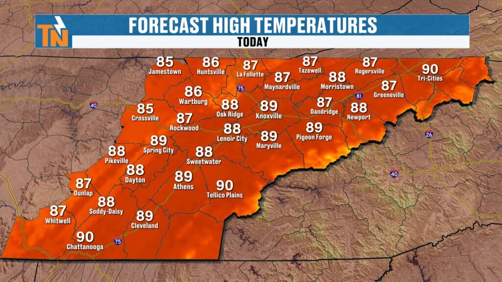
Temperatures today warm into the upper 80s.
That’s right near average.
But with dew points climbing, it will feel hotter.
Heat index values push into the low 90s.
And this is where we begin paying attention to heat stress.
Especially for:
- Outdoor sports
- Summer practices
- Camps
- Kids outside for extended periods
The Tennessee Secondary School Athletic Association uses Wet Bulb Globe Temperature (WBGT) for outdoor safety.
That becomes much more important next week.
Today isn’t dangerous.
But it’s the start of what’s coming.
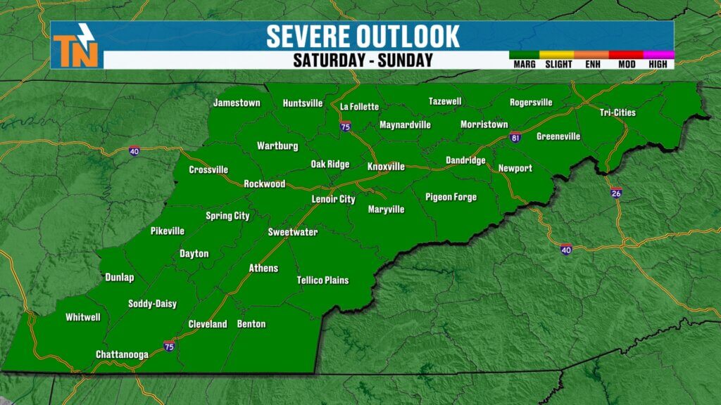
Saturday Brings Better Storm Coverage
Saturday is our more active weather day.
We start the morning mostly quiet.
But as that front sags into East Tennessee, storm chances increase.
Timeline for Saturday:
Morning:
Mostly quiet with a few scattered showers possible.
Midday into afternoon:
Storm coverage increases.
Evening:
A few more rounds of showers and thunderstorms possible.
This will not be a washout.
But it will be an active weather day.
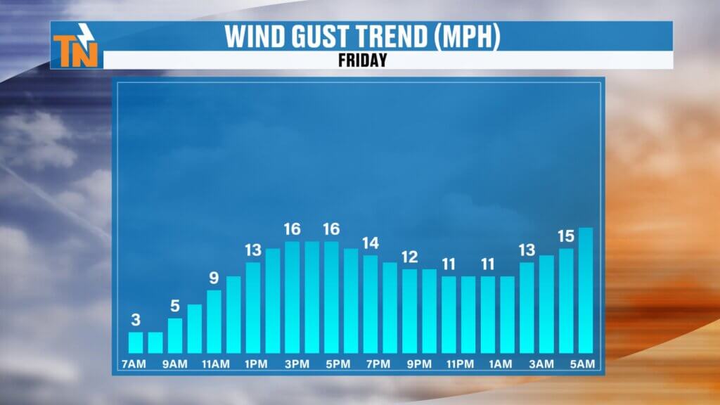
And some storms could produce:
- Heavy rainfall
- Gusty winds
- Frequent lightning
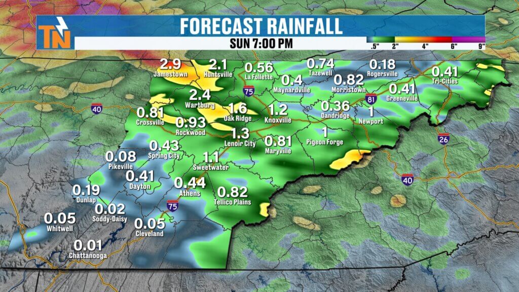
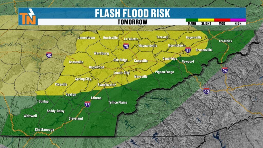
Flooding Risk Increases This Weekend
Because moisture levels continue rising, the Weather Prediction Center has issued:
Level 1 and Level 2 risks for localized flooding and flash flooding.
This is not widespread flooding.
But where storms repeatedly track over the same area, rainfall can pile up quickly.
Some spots may pick up:
Up to 1 inch of rain or more through the weekend.
And some isolated areas could exceed that.
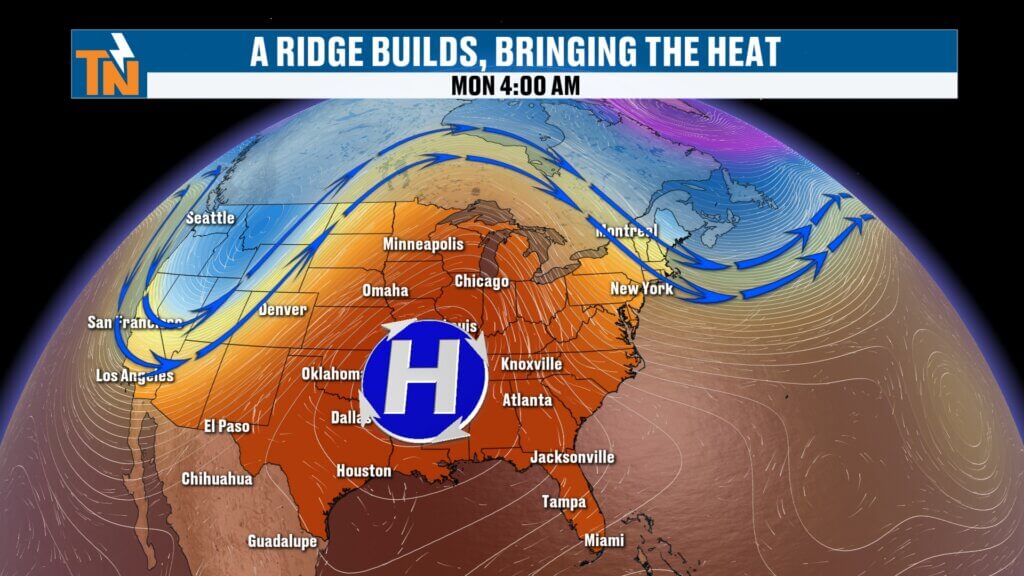
Sunday Improves, Then Heat Dome Builds
Sunday still starts unsettled.
We could see lingering showers and thunderstorms from sunrise through late morning.
By afternoon:
Conditions improve.
Clouds begin breaking.
Storms move out.
And then the next major weather player takes over.
A strong ridge of high pressure.
This is your classic summer heat dome.
And once it builds in:
Rain shuts down.
Temperatures soar.
Humidity stays high.
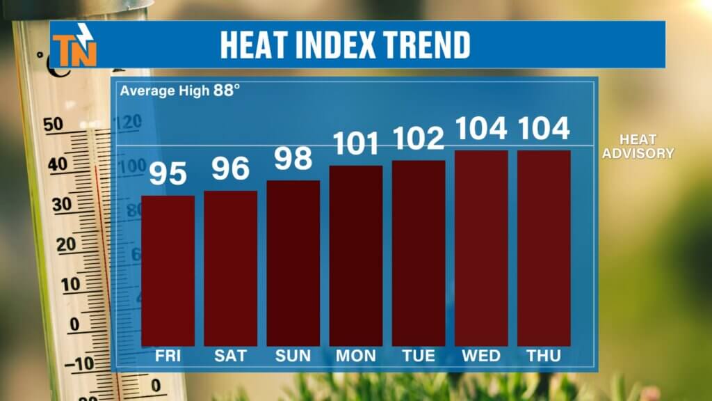
Dangerous Heat Builds Next Week
This will likely be the hottest stretch we’ve seen so far this season.
Forecast highs:
Monday: Low 90s
Tuesday: Mid 90s
Wednesday: Mid 90s
Thursday: Mid 90s
But with dew points in the low to mid 70s…
Heat index values could approach 100 to 105 degrees.
That’s near Heat Advisory criteria.
And that’s where heat safety becomes critical.
Drink water.
Take breaks.
Limit outdoor activity during peak heating.
And keep checking in for updates.
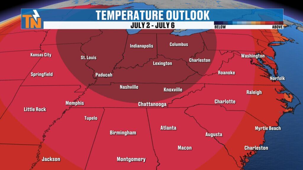
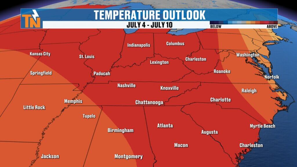
Fourth of July Outlook: Hot Pattern Continues
Looking beyond the 7-day forecast, the Climate Prediction Center continues signaling above-average temperatures through the first half of July.
That means:
The heat likely sticks around.
And the Fourth of July period could be one of the hotter stretches we’ve seen this summer.
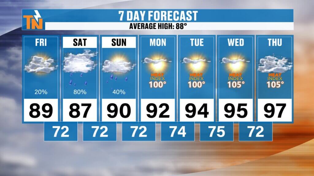
East Tennessee 7-Day Forecast
Friday
Partly sunny
Spotty storms north
High: 88°
Saturday
Scattered showers and storms
Heavy rain possible
High: 88°
Sunday
Morning storms, improving later
High: 87°
Monday
Hotter and humid
High: 91°
Tuesday
Hot and muggy
Heat index near 100°
High: 94°
Wednesday
Very hot
Heat index near 105°
High: 95°
Thursday
Continued summer heat
High: 95°
Bottom Line
Today starts warm and mostly dry.
Storm chances increase tonight and especially Saturday.
Sunday improves.
And then the real story becomes the heat.
By next week, East Tennessee shifts into a true summer pattern:
Hot.
Humid.
Rain-free.
Potentially dangerous heat.
Stay weather aware this weekend.
And stay heat aware next week.
Have a great Friday, enjoy the weekend, and keep checking in with the East Tennessee Weather app for radar and forecast updates.