
Good morning and happy Sunday, East Tennessee!
I sure hope you had a fantastic Fourth of July weekend. It may have been a little bit of a late night for some of you. I know it certainly was for the Witcher family!
Let’s get right to the forecast.
Yesterday turned out a little cooler than expected thanks to morning showers and thunderstorms along with plenty of mid-level cloud cover. Knoxville officially topped out at 91 degrees, several degrees below the forecast high of 94.
Now, the good news.
The dangerous heat we’ve been dealing with over the past week is finally beginning to ease.
Heat Advisories Are Ending
The ridge of high pressure that brought us the first major heat wave of the summer is beginning to weaken and slide away.
That means the Heat Advisories and Extreme Heat Warnings are finally moving out across much of the region.
Replacing that ridge is a weak upper-level trough that will settle into the Tennessee Valley over the next couple of days.
And while that means slightly lower temperatures…
It also means better chances for afternoon showers and thunderstorms.
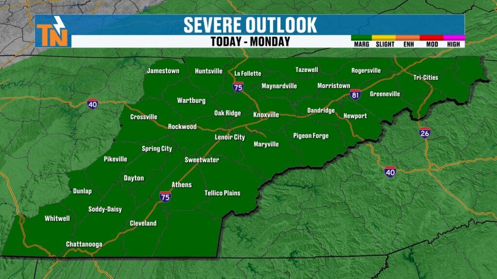
Storm Risk Today
The atmosphere is becoming more active again.
The Storm Prediction Center has placed all of East Tennessee under a Level 1 Marginal Risk for isolated severe thunderstorms.
Meanwhile, the Weather Prediction Center also continues a Level 1 Risk for localized flooding and flash flooding.
Neither outlook suggests widespread severe weather.
Instead, we’re looking at the typical summertime setup where a few storms become strong while many locations stay dry.
Timing the Rain
The first half of today looks fantastic.
Early this morning we’ll enjoy:
- Mostly sunny skies
- Areas of patchy fog
- Warm and humid conditions
If you’re planning to head:
- To the lake
- Out fishing
- To the pool
- On a hike
The morning and early afternoon will offer your best weather.
As daytime heating builds, scattered thunderstorms will begin developing.
Expected timing:
- Noon to 2 PM: Mostly dry
- 2 PM to 5 PM: Storms begin developing
- 5 PM to 9 PM: Greatest coverage
- 9 PM through Midnight: A few storms continue before gradually winding down
These won’t be widespread storms.
But the ones that develop could produce:
- Torrential rainfall
- Frequent lightning
- Gusty winds
- Brief localized flooding
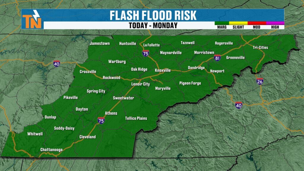
Flooding Still a Concern
We’ve seen this pattern several times already this summer.
The atmosphere contains plenty of moisture.
That means storms become extremely efficient rain producers.
Rainfall rates of 1 to 2 inches per hour are certainly possible underneath the heavier storms.
Most neighborhoods won’t have problems.
But if one of these storms parks over your location, localized flooding could develop quickly.
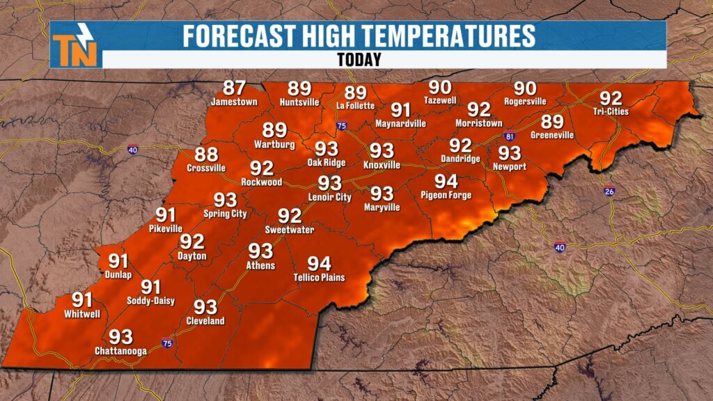
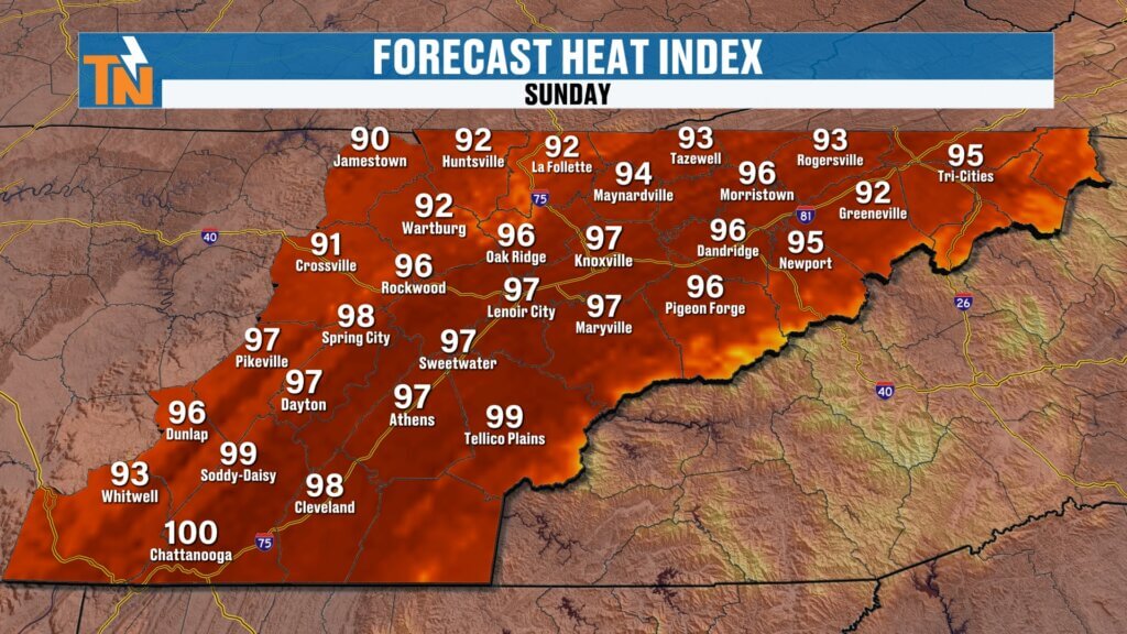
Temperatures Today
Morning temperatures begin in the lower to middle 70s, a touch warmer than yesterday.
Winds stay light throughout the day.
Afternoon highs climb into the lower 90s, just a couple of degrees warmer than Saturday.
The difference today is that while it’s still hot and humid, it won’t feel nearly as oppressive as it did earlier this week.
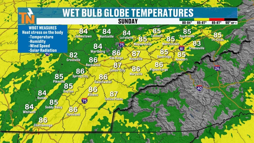
Wet Bulb Globe Temperature Improving
Finally, some good news.
The Wet Bulb Globe Temperature continues trending downward.
That’s important because it measures the combined effects of:
- Air temperature
- Humidity
- Wind
- Solar radiation
Earlier this week we were flirting with the highest danger categories.
Today those values come down enough that outdoor activities become a little more manageable.
It’s still hot.
You’ll still want:
- Plenty of water
- Shade whenever possible
- Frequent cooling breaks
But it’s certainly an improvement over where we were just a few days ago.
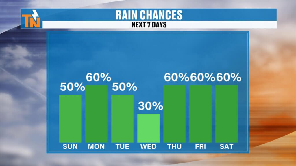
Looking Ahead
Our rain chances stay elevated through Tuesday before briefly decreasing Wednesday.
Another increase in moisture may arrive late next week.
Rain Chances
- Sunday: 50%
- Monday: 50%
- Tuesday: 50%
- Wednesday: Lower coverage
- Thursday through Saturday: Rain chances increase again
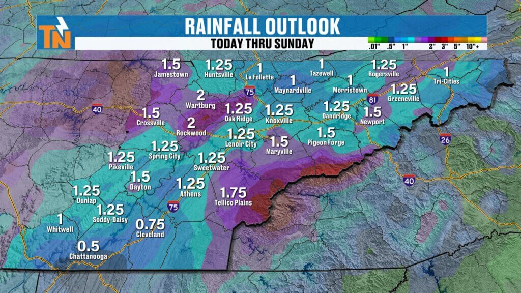
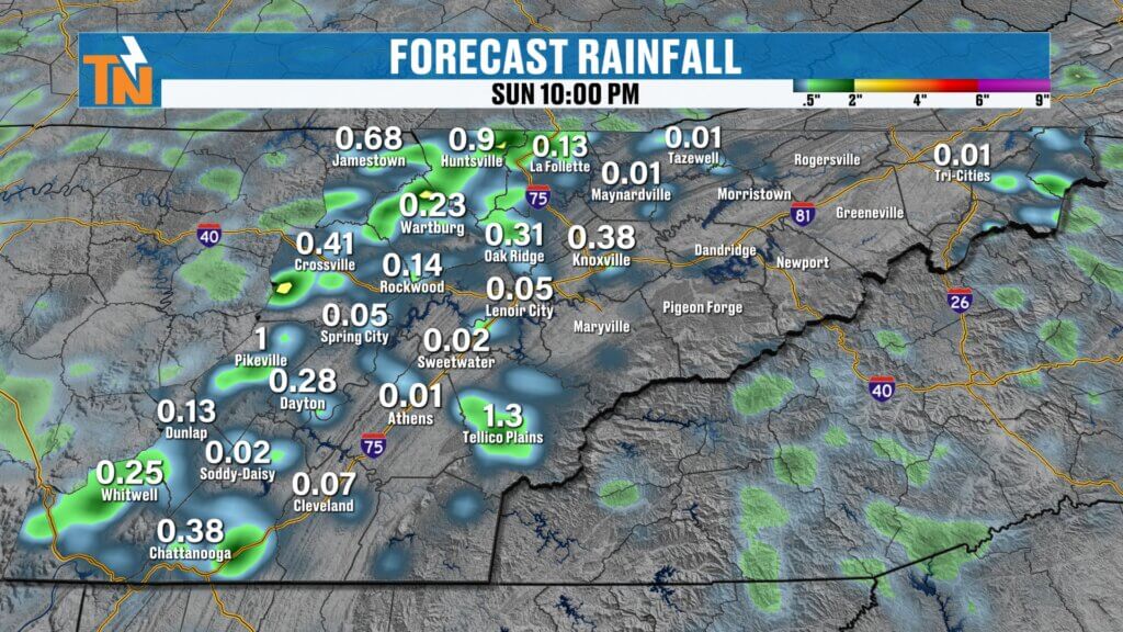
Seven-Day Rainfall Outlook
Over the next week, much of East Tennessee could receive around an inch of rainfall, with locally higher totals in the mountains and along the Cumberland Plateau.
Most storms will develop over the higher terrain before drifting into the Valley during the late afternoon and evening.
That continues to be the classic summertime pattern.
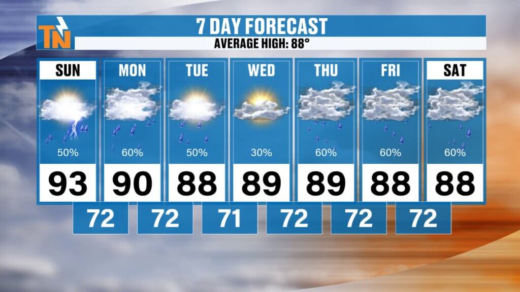
7-Day Forecast
- Sunday: High 91°, scattered afternoon storms
- Monday: Low 90s, scattered storms
- Tuesday: Near 90°, afternoon storms
- Wednesday: Upper 80s, fewer storms
- Thursday: Upper 80s, increasing rain chances
- Friday: Upper 80s, scattered storms
- Saturday: Upper 80s, scattered afternoon storms
While temperatures come down a few degrees this week, dew points remain elevated.
That means it’ll still feel humid, with afternoon heat index values generally reaching the upper 90s.
Bottom Line
The dangerous heat wave is finally easing.
Temperatures remain hot but are becoming a little more manageable.
The tradeoff?
Daily afternoon thunderstorms return.
Some storms today could become strong with heavy rain, gusty winds, and frequent lightning, so if you have outdoor plans, enjoy the first half of the day and keep an eye on the sky later this afternoon.
As always, track storms in real time with the free East Tennessee Weather App, where you’ll find interactive radar, daily forecasts, live weather updates, and everything you need to stay weather aware across East Tennessee.
Have a fantastic Sunday!