
Good morning and happy Friday, East Tennessee!
As we head into the Fourth of July holiday weekend, the big story continues to be the heat. Yesterday was another scorching day across the Tennessee Valley, and several locations either tied or came within a degree of record highs.
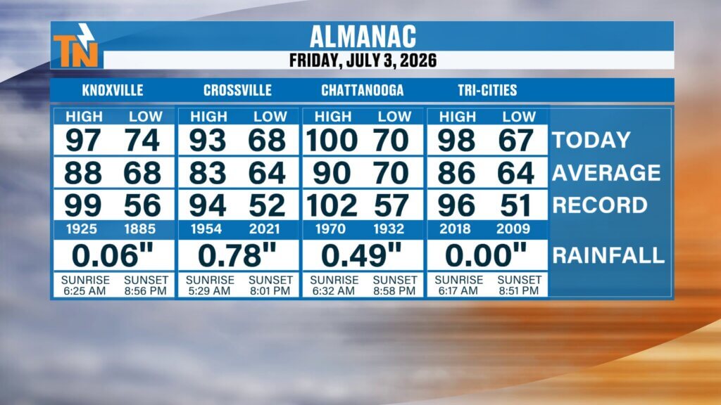
Chattanooga reached 100°, breaking the old record of 99° set in 1953.
Knoxville climbed to 97°, just one degree shy of the record high of 98°, while Crossville and the Tri-Cities also came within a degree of their daily records.
This has been our first significant heat wave of the summer, and while relief is on the horizon, today and tomorrow will remain dangerously hot.
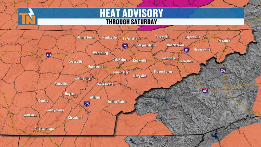
Heat Advisory Remains in Effect
Heat Advisories continue across East Tennessee through Saturday as a strong ridge of high pressure remains firmly in control of our weather pattern.
Morning temperatures are already starting in the lower to upper 70s, and with dew points remaining in the 70s, you’ll notice the heat and humidity the moment you step outside.
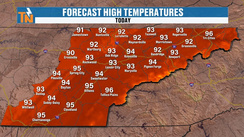
This afternoon we’ll climb back into the middle 90s, but the air temperature only tells part of the story.
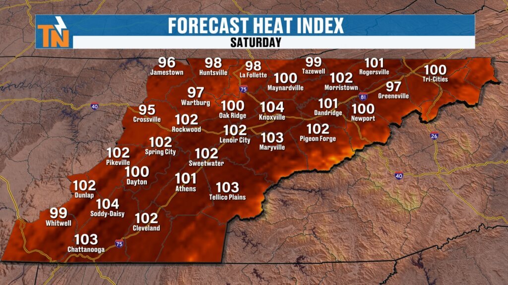
Heat index values will once again reach 100° to 107° in some communities.
If you have outdoor plans, be sure to:
- Drink plenty of water
- Take frequent breaks in the shade or air conditioning
- Wear light-colored, loose-fitting clothing
- Never leave children or pets inside a parked vehicle
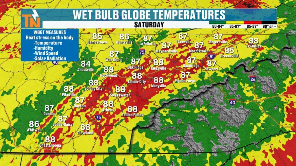
Wet Bulb Globe Temperature Remains Dangerous
I’ve been talking a lot this week about the Wet Bulb Globe Temperature (WBGT), and today is another day to pay attention.
WBGT combines:
- Air temperature
- Humidity
- Wind speed
- Solar radiation
Today’s values will climb into the upper 80s and lower 90s, placing us in one of the highest danger categories.
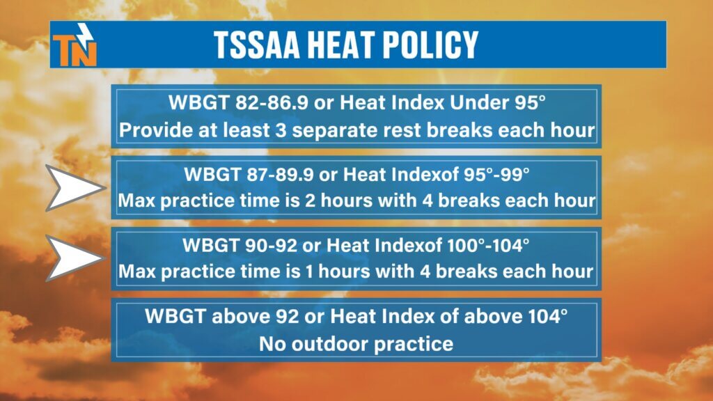
These are the same measurements the TSSAA uses for athletic practices, requiring frequent cooling breaks.
Even if you’re not coaching football or marching band, these guidelines are excellent for anyone working outside.
If you’re doing yard work, roofing, construction, landscaping, or spending the day at the lake, your body will thank you for taking frequent breaks.
Spotty Afternoon Storms Return
While heat remains the main story, we do have a slightly better opportunity for a few afternoon thunderstorms today.
The atmosphere remains extremely unstable, and another small disturbance will slide into East Tennessee during the afternoon.
The Storm Prediction Center continues a Level 1 (Marginal Risk) for isolated strong thunderstorms.
The timing looks to be:
- Dry through lunchtime
- Storms developing after 2–3 PM
- Greatest coverage between 4 PM and 7 PM
- Activity fading after sunset
Most communities will stay dry.
But if you do see a storm, expect:
- Strong wind gusts
- Frequent lightning
- Torrential tropical-style rainfall
- Brief localized flooding
These storms will be very hit-or-miss, but any one that develops will have plenty of moisture available to produce heavy rain.
Fourth of July Forecast
The Fourth of July still looks very workable across East Tennessee.
It will simply be another hot one.
Morning temperatures begin in the 70s before afternoon highs climb into the middle 90s.
If you’re heading to parades, cookouts, festivals, or downtown Knoxville celebrations, expect:
- High near 95°
- Heat index around 103°
- Light winds
- Mostly sunny skies with building afternoon clouds
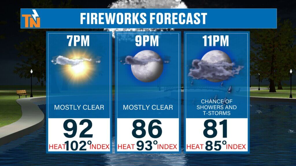
A few isolated thunderstorms may develop during the afternoon, mainly drifting off the mountains and the Cumberland Plateau into portions of the Valley.
The good news?
Right now, many of those storms should begin weakening toward sunset, so fireworks displays still have a good chance of going off without major weather issues.
Of course, continue checking radar before heading out because these pop-up storms can develop quickly.
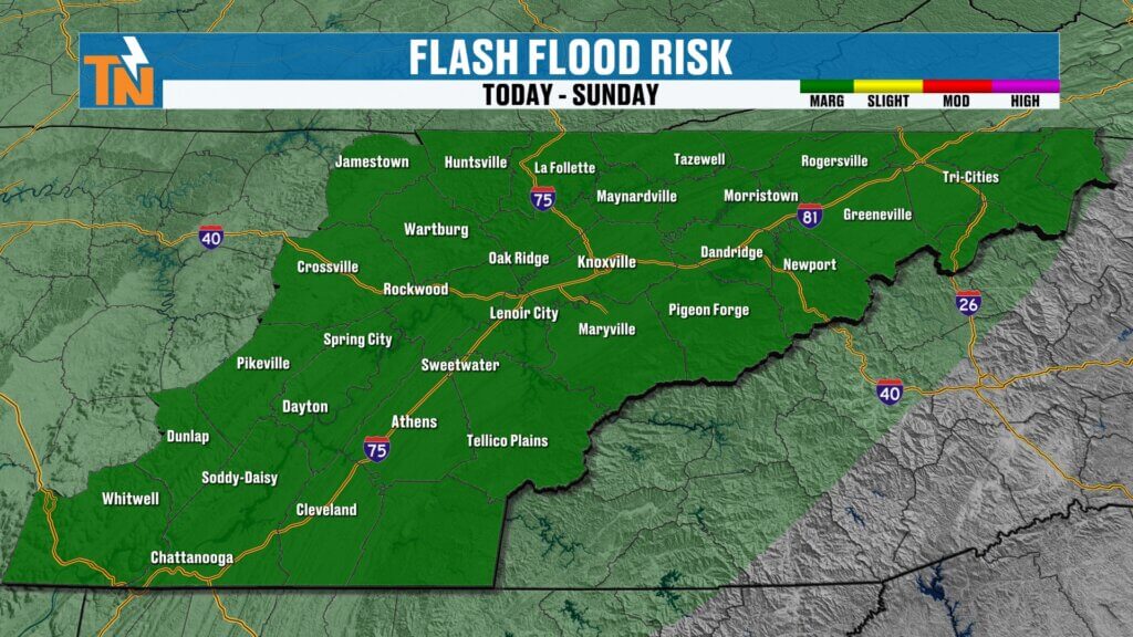
Flooding Risk Remains Low but Localized
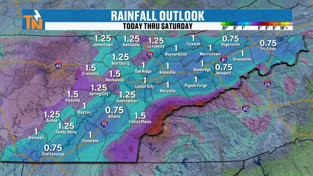
Because of the tropical moisture still in place, the Weather Prediction Center continues a Level 1 excessive rainfall outlook for portions of the region on Saturday.
This does not mean widespread flooding.
Instead, any thunderstorm that develops could briefly produce one to two inches of rain in a short period of time, creating isolated flooding concerns.
Looking Ahead
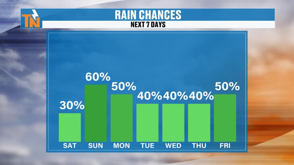
Rain chances gradually increase early next week as the ridge begins to weaken.
That’s actually good news.
More clouds and more afternoon thunderstorms will help knock temperatures back closer to average.
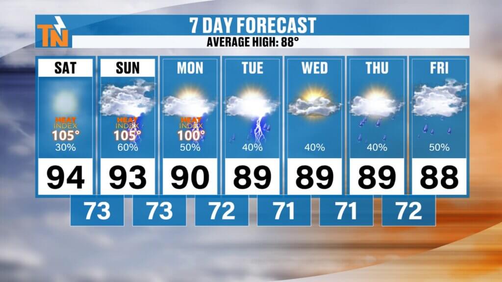
7-Day Outlook
Friday
- High: 95°
- Heat index: 100–107°
- 30% chance of afternoon storms
Saturday (Fourth of July)
- High: 95°
- Heat index near 103°
- 40% chance of isolated afternoon storms
Sunday
- Hot and humid
- Isolated afternoon storms
Monday – Wednesday
- Better coverage of afternoon showers and thunderstorms
- Highs returning to the upper 80s and lower 90s
- More typical July weather
Bottom Line
The holiday weekend begins with dangerous heat.
Today and Saturday remain the hottest days, with heat index values exceeding 100 degrees in many locations.
A few isolated afternoon thunderstorms are possible both days, but many communities stay dry.
As we move into next week, rain chances increase, temperatures ease back toward seasonal averages, and we settle into a more typical summertime pattern.
Have a fantastic Friday, enjoy the holiday weekend, stay hydrated, and be sure to keep the East Tennessee Weather Apphandy to track any pop-up storms before your Fourth of July plans.