
Good Thursday morning, East Tennessee!
I hope you’ve had a great week. As we head toward the weekend, our weather pattern is beginning to change. Today’s forecast will look very similar to what we experienced yesterday, but you’ll start to notice increasing humidity and gradually increasing afternoon shower and thunderstorm chances as a trough begins digging into the eastern United States.
The weekend won’t be a washout by any means, but you’ll definitely want to keep an eye on the radar if you have outdoor plans.
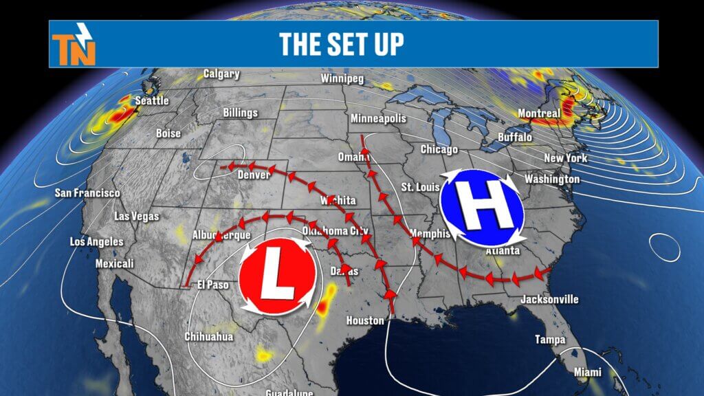
The Weather Pattern Is Beginning to Shift
For the past several days, high pressure has been in control of our weather. That ridge is now beginning to slide farther to our south and southeast while an upper-level low remains parked over West Texas.
As this pattern evolves, winds in the upper atmosphere will shift, allowing several weak disturbances to move across East Tennessee through the weekend.
The result?
- Isolated showers and thunderstorms today
- Better coverage Friday
- More scattered storms Saturday
- Another round on Sunday
That does not mean it rains all day, every day.
Instead, expect the typical summertime pattern where most of the day is dry before scattered afternoon and evening thunderstorms develop.
Some neighborhoods will receive a soaking rain while others may stay completely dry.
Canadian Wildfire Smoke Continues Across the Northeast
One interesting feature on the larger weather map is the jet stream transporting Canadian wildfire smoke into the Northeast.
If you’ve seen photos from cities farther north showing hazy skies and poor air quality, that’s exactly what’s happening. Fortunately, East Tennessee remains well south of the thickest smoke plume, so our air quality will remain much better.
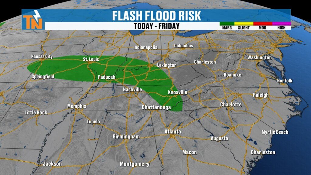
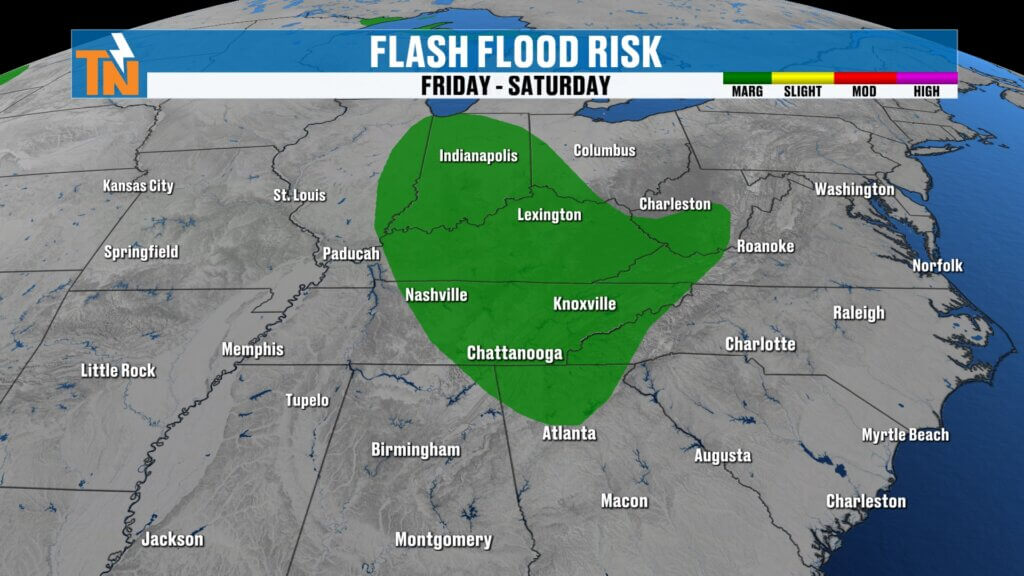
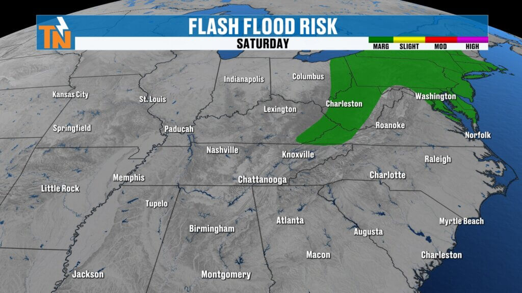
Flood Risk Returns
Although storms will remain scattered, the atmosphere continues to hold an incredible amount of moisture.
That means any thunderstorm that develops will be capable of producing:
- Tropical-like downpours
- Frequent lightning
- Gusty winds
- Localized flooding
Because of that, the Weather Prediction Center has placed portions of East Tennessee under a Level 1 Risk for excessive rainfall today.
Today’s greatest concern includes:
- Central Valley
- Southern Valley
- Cumberland Plateau
The flood risk continues Friday before shifting slightly farther north over the weekend.
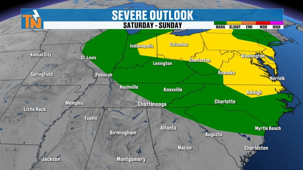
Severe Weather Potential This Weekend
While today’s severe weather threat remains fairly limited, a little more energy arrives by Saturday and Sunday.
That means we’ll have the opportunity for a few isolated strong thunderstorms this weekend capable of producing:
- Damaging wind gusts
- Frequent lightning
- Very heavy rainfall
Most storms will remain below severe limits, but a few stronger cells can’t be ruled out.
Today’s Forecast
Much like yesterday, we’ll watch scattered afternoon thunderstorms develop during the heat of the day.
The best chance for rain today will be:
- Cumberland Plateau
- Southern Valley
- Areas south of Interstate 40
Meanwhile, much of Upper East Tennessee and locations north of Interstate 40 will likely stay drier.
Storms will be slow movers, allowing them to dump a lot of rain over a short period of time.
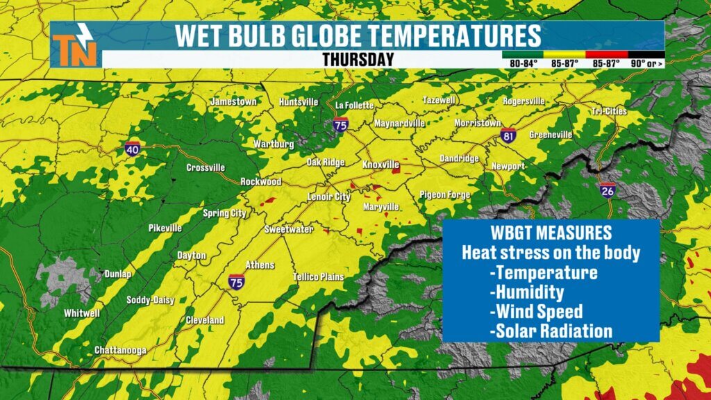
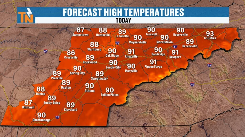
Temperatures
We’ll begin the morning with temperatures in the 60s and lower 70s under warm and muggy conditions.
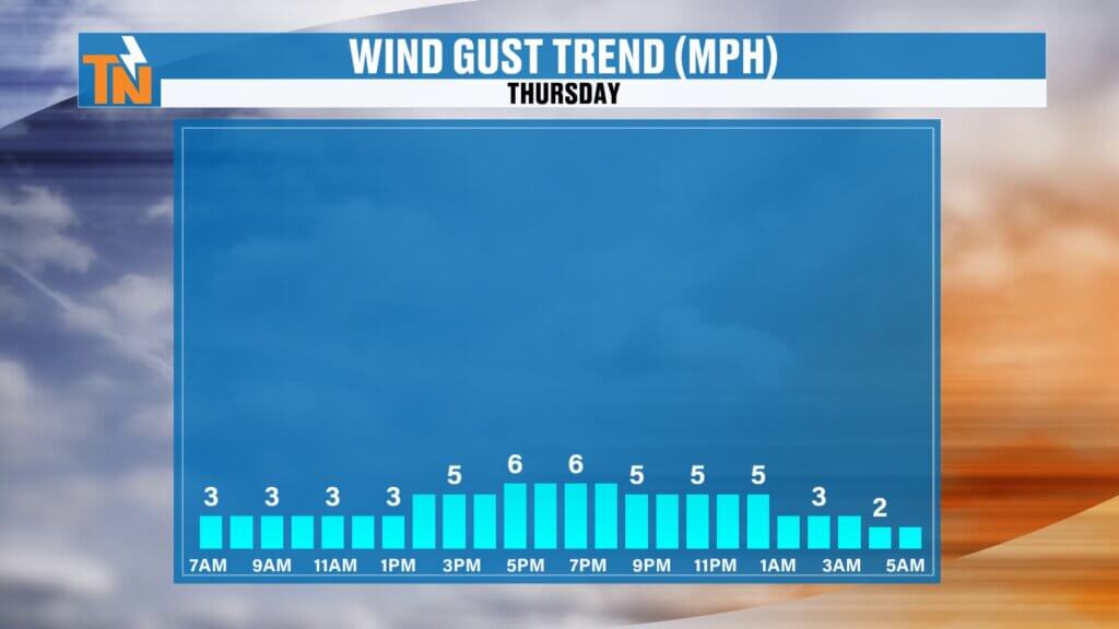
Winds remain light throughout the day.
Afternoon highs climb into the lower 90s, right around seasonal averages for early July.
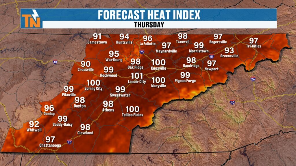
Thanks to the humidity, however, it’ll feel much hotter.
Heat index values will climb into the upper 90s and lower 100s this afternoon.
If you’re working outside, exercising, or spending several hours outdoors, be sure to:
- Stay hydrated
- Take frequent breaks
- Spend time in the shade whenever possible
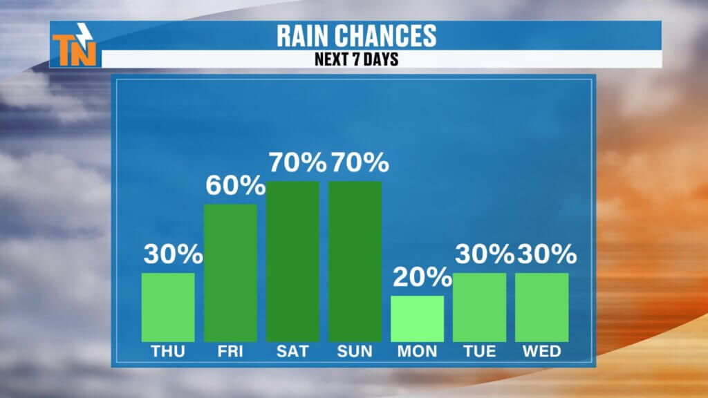
Rain Chances Increase Into The Weekend
Rain chances gradually increase over the next several days.
- Thursday: 30%
- Friday: 60%
- Saturday: 60–70%
- Sunday: 60–70%
Remember, these percentages do not mean it rains all day.
They simply indicate the probability that you’ll receive measurable rainfall at some point during the day.
The timing, duration, intensity, and rainfall totals will vary from one location to another.
Moisture Begins Decreasing Early Next Week
As we move into Sunday night and Monday, moisture levels begin decreasing slightly.
That doesn’t necessarily mean completely dry weather—it simply means there will be less available moisture in the atmosphere for widespread thunderstorm development.
We’ll likely transition back toward a more typical summertime pattern with isolated afternoon storms and more sunshine next week.
Regional Forecast
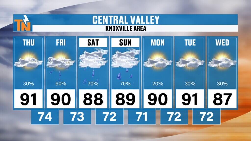
Central Valley (Knoxville)
Highs reach the lower 90s today and Friday before dropping back into the upper 80s this weekend thanks to increased cloud cover and storm chances.
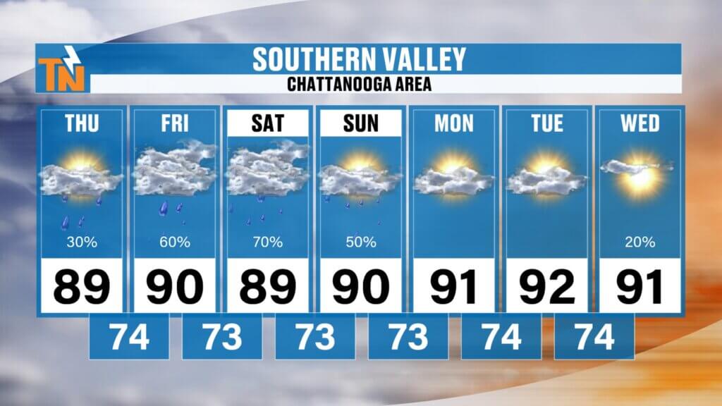
Southern Valley (Chattanooga)
Expect upper 80s to lower 90s with the highest chance of afternoon thunderstorms each day, especially Friday through Sunday.
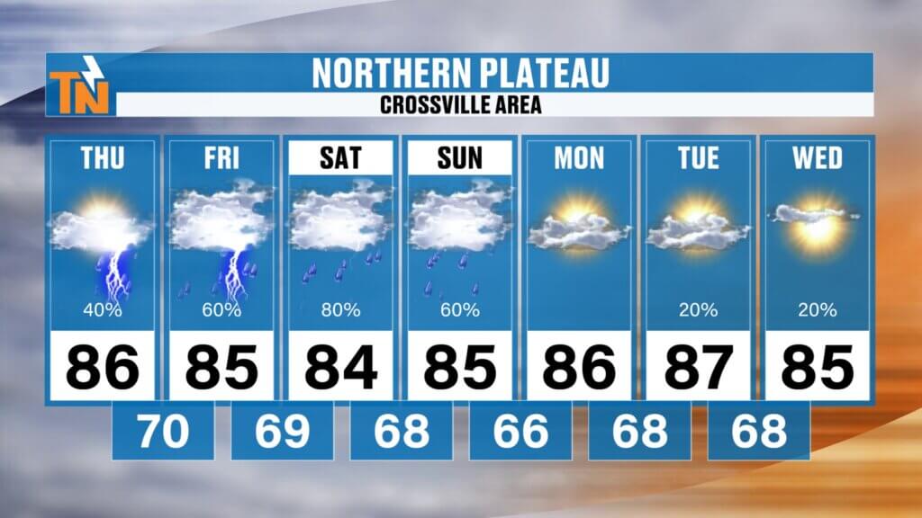
Cumberland Plateau
High temperatures stay in the middle 80s with scattered afternoon storms becoming more common through the weekend.
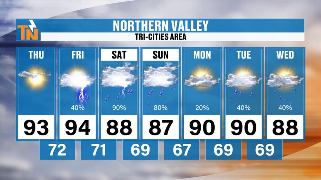
Upper East Tennessee
The Tri-Cities region remains one of the warmer and drier locations today before storm chances increase Friday through the weekend.
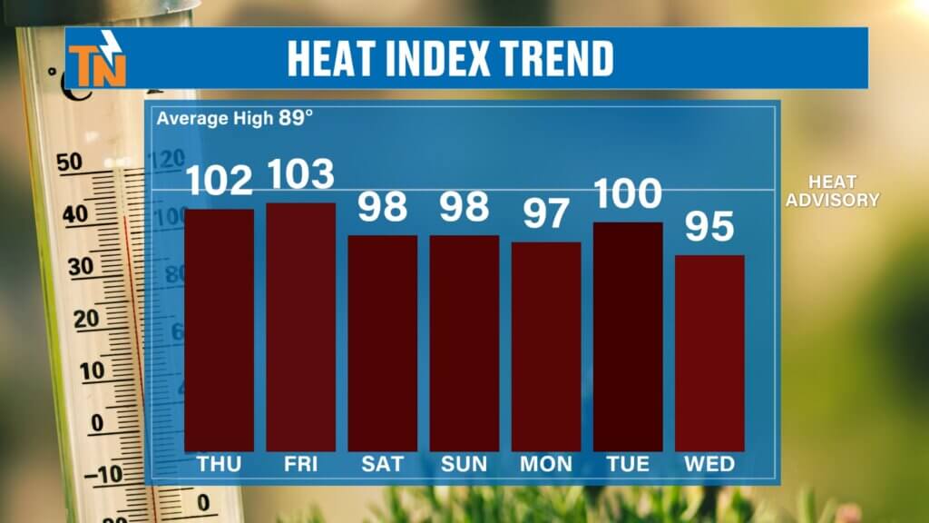
Heat Index Remains Elevated
Even though temperatures cool slightly over the weekend, humidity remains high.
That means heat index values will continue running:
- Low 100s today and Friday
- Upper 90s to near 100° Saturday through Tuesday
It’ll still feel very much like July.
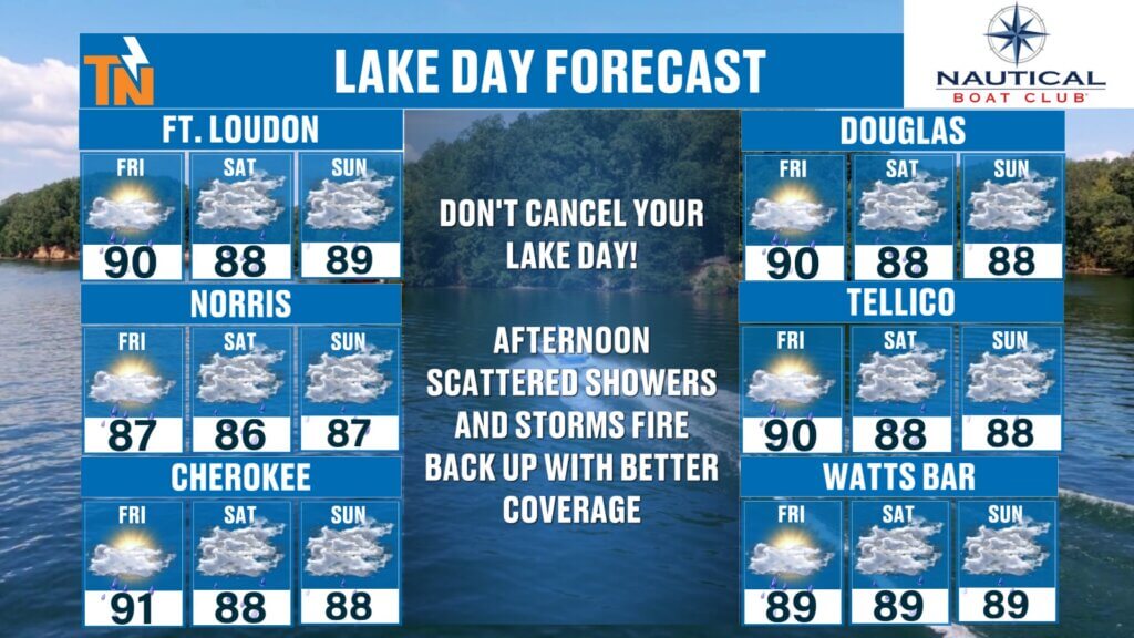
Planning Time On The Lake?
Today is probably your best opportunity to enjoy the water before storm chances become more widespread.
Friday through Sunday should still offer plenty of opportunities to boat, fish, or spend time at the lake—but you’ll want to head out earlier in the day before scattered afternoon thunderstorms develop.
The best tool to track those storms is the free East Tennessee Weather App.
The app includes:
- Interactive radar
- Future radar
- Lightning alerts within 15 miles
- Push notifications for severe weather
It’s a great resource if you’re spending time outdoors this weekend.
The Bottom Line
Today’s forecast features another warm and humid summer day with isolated afternoon thunderstorms, mainly south of Interstate 40.
Storm coverage gradually increases Friday through the weekend as several disturbances move across the region.
Not everyone will receive rain every day, but any storms that develop will be capable of producing tropical downpours, localized flooding, and a few strong wind gusts.
Enjoy today, keep an eye on the radar this weekend, and I’ll continue to keep you updated with the latest forecast on the East Tennessee Weather App, YouTube, Roku, Amazon Fire, and all eastTNweather platforms.