
Published: Sunday, September 6, 2026
By Meteorologist Mike Witcher | eastTNweather
Good morning and Happy Sunday!
It’s going to be a little bit of a wash, rinse, repeat forecast across East Tennessee today. We’re still hot, we’re still humid, and scattered thunderstorms will once again be possible.
There is, however, one important change this morning.
The Storm Prediction Center has placed portions of East Tennessee under a Level 1 risk for severe thunderstorms, including parts of the Southern Valley, Central and Northern Valley, and especially the mountain counties.
That doesn’t mean everyone gets a storm today. In fact, many locations may stay completely dry.
But if you have outdoor plans, you’ll want to stay weather aware this afternoon.
Northwest Flow Brings Another Storm Chance
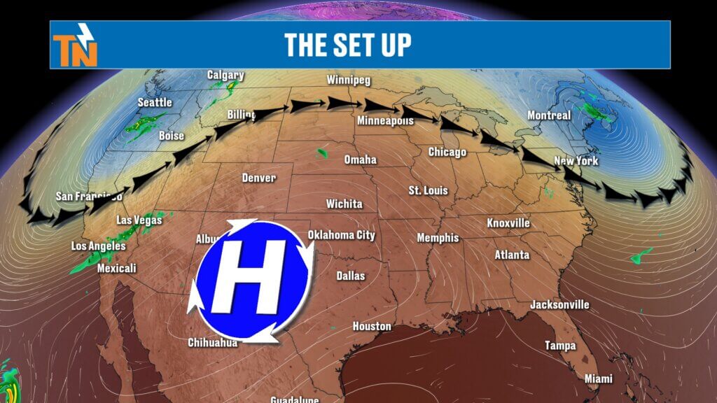
We’re caught between two larger weather systems.
A ridge of high pressure remains centered to our west while an area of low pressure and troughing sits to our north and northeast. That puts East Tennessee underneath a northwesterly flow in the mid and upper levels of the atmosphere.
There’s also an upper-level disturbance moving through that flow, along with a surface cold front.
Put everything together, add daytime heating and plenty of humidity, and we’ve got the ingredients for scattered thunderstorms this afternoon.
Where Is the Greatest Storm Risk?
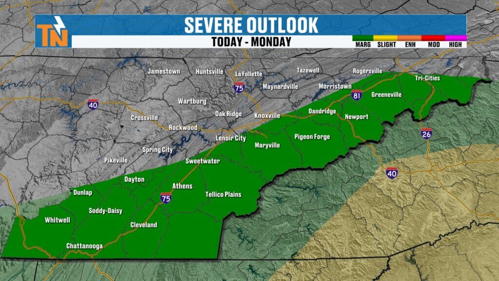
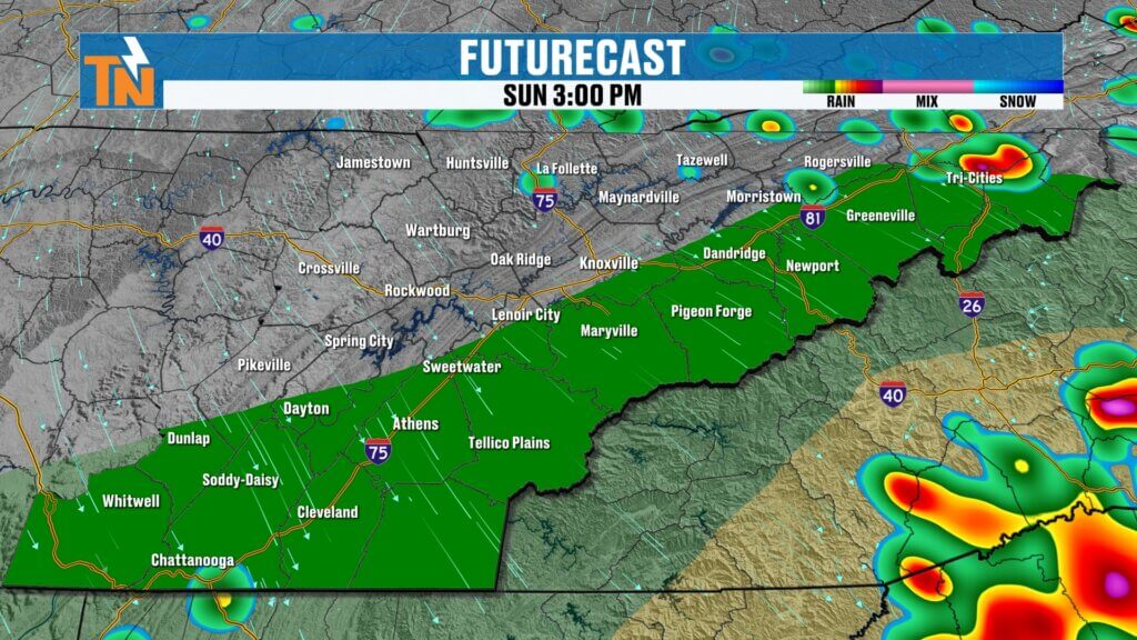
Some storms have already been rolling through portions of southwest Virginia and near Upper East Tennessee this morning.
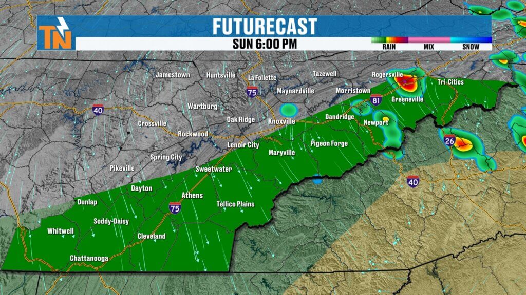
As we heat the atmosphere through the afternoon, additional thunderstorms should begin developing.
The better concentration initially appears to favor areas north and northeast of Knoxville and into Upper East Tennessee and the mountain counties.
But don’t focus too heavily on an exact line on the map.
Thunderstorms can generate outflow boundaries, and those boundaries can become the trigger for additional storms farther south and west.
That’s why even if you’re technically outside the highlighted severe-weather risk, you should still keep an eye on the sky and radar.
A Few Storms Could Become Strong to Severe
We’re not expecting widespread severe weather across East Tennessee.
This is more of an isolated severe-weather setup.
Any stronger thunderstorm could produce:
• Strong to damaging wind gusts
• Hail
• Frequent lightning
• Torrential rainfall
We could certainly see some Special Weather Statements today, and I wouldn’t be surprised if an isolated Severe Thunderstorm Warning is needed somewhere across the region.
We’ve already seen what these storms can do over the past couple of days.
Overnight Storms Produced Flash Flooding
Some communities didn’t have to wait until today for thunderstorms.
Strong storms developed overnight around portions of Spring City, Rhea, Meigs and Cumberland counties, and a Flash Flood Warning was issued while many people were sleeping.
That’s another reminder that these storms contain plenty of moisture.
The heaviest rainfall today appears more likely across Upper East Tennessee and the mountain counties, but locally heavy downpours are possible anywhere a stronger storm develops.
Hot & Humid — But Not Quite as Hot
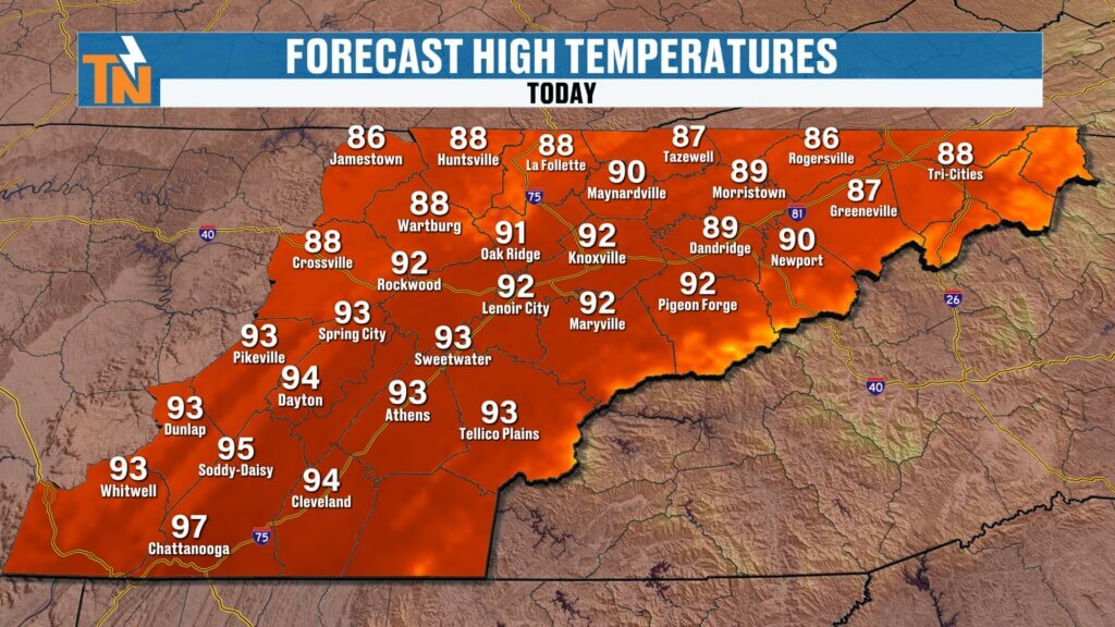
Temperatures today should be a degree or two cooler than Saturday.
That’s not exactly a cold front worth celebrating.
We’re still talking about temperatures running roughly 6° above average in parts of the region.
And humidity isn’t going anywhere yet.
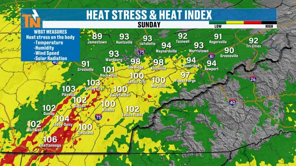
Heat index values south of Interstate 40 could still reach the upper 90s and lower 100s, particularly across the Southern Valley.
There is currently no Heat Advisory for East Tennessee, but that doesn’t mean you should ignore the heat.
If you’re spending several hours outside, continue to hydrate and take breaks.
Big Kahuna Festival Weather
We’ve got a BIG day in downtown Knoxville with the Big Kahuna Festival at World’s Fair Park.
I’ll be there with eastTNweather, and I’ll also be watching the radar throughout the event.
Right now, don’t cancel your plans.
We’re talking about scattered thunderstorms, not an all-day rain.
But lightning is obviously something we’ll need to monitor closely.
Remember: lightning is your first line of defense.
If you’re heading downtown, keep the FREE eastTNweather app handy and make sure your location services and notifications are turned on.
Hot Air Balloon Festival: Wind Matters Too
We’re also watching the weather closely for the Monroe County Hot Air Balloon Festival.
Thunderstorms aren’t the only concern when you’re dealing with hot air balloons.
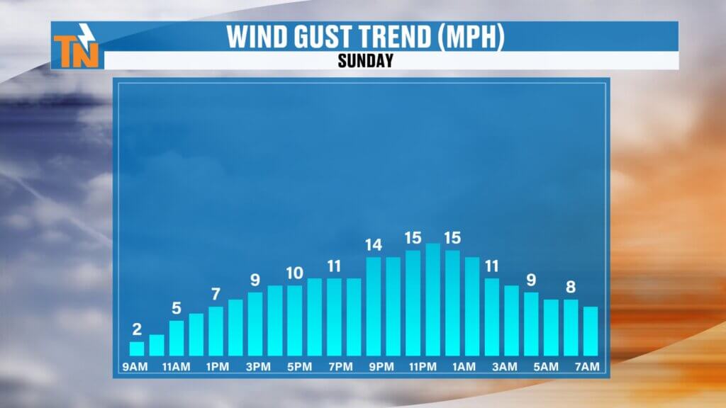
Winds will be a little stronger today compared with the very light winds we’ve experienced underneath the ridge recently.
We’re caught between weather systems, creating a somewhat stronger pressure gradient and therefore a little more wind.
Whether conditions remain favorable for balloon operations will ultimately depend on what happens locally this afternoon and evening.
Labor Day Monday: A Little Cooler
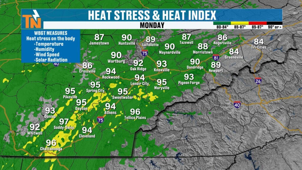
Labor Day Monday brings another opportunity for spotty showers and thunderstorms, but temperatures should come down slightly.
That also means somewhat lower heat index values and less heat stress.
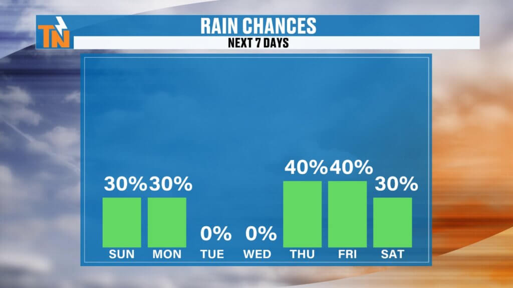
I’m carrying around a 30% rain chance Sunday and Monday, but remember what that number does—and doesn’t—tell you.
It does NOT mean it rains for 30% of your day.
It does NOT mean everybody gets wet.
It tells us about the probability of measurable precipitation at a given location within the forecast area.
The important message for your plans is simple:
Keep your plans, but keep radar nearby.
Drier Tuesday & Wednesday
Tuesday and Wednesday currently look considerably quieter.
We’ll bring rain chances way down while temperatures remain hot.
Then things could become more interesting toward the end of the week.
Watching a Late-Week Trough & Cold Front
Forecast guidance continues to advertise a trough potentially digging into the eastern United States later this week.
If that develops as currently projected, our rain chances could increase again Thursday and Friday and potentially into next weekend.
Even more interesting is what could follow.
Some longer-range guidance is showing multiple cold fronts over the next couple of weeks.
We’re not talking about winter coats, but we could eventually get a legitimate taste of early fall with lower humidity and cooler mornings.
I’ll believe the specifics when we get closer, but it’s certainly something worth watching.
We Also Need Some Rain
We’ve had plenty of heavy rain and flooding this summer, so saying we “need rain” may sound strange.
But we’re entering a much different part of the calendar.
September begins our climatological transition into the drier portion of the year, and October is typically our driest month.
Longer-range guidance currently favors a relatively dry pattern during portions of mid-September.
That means we’ll need to monitor soil moisture and the U.S. Drought Monitor closely over the next several weeks.
We don’t want drought conditions becoming established heading into our driest time of year.
Bottom Line
SUNDAY: Hot and humid with scattered afternoon thunderstorms. A few could become strong to severe, especially across Upper East Tennessee and the mountains. Damaging wind, hail, lightning and locally heavy rain are the main concerns.
LABOR DAY MONDAY: Slightly cooler with another opportunity for isolated/scattered storms.
TUESDAY–WEDNESDAY: Hotter again but mainly dry.
THURSDAY–FRIDAY: Rain and thunderstorm chances may increase as another trough and cold front approach.
NEXT WEEKEND: Still some uncertainty, but there are hints of another pattern change that could eventually bring some relief from the heat and humidity.
If you’re heading to the Big Kahuna Festival, the Hot Air Balloon Festival, the lakes or anywhere else outdoors today, don’t cancel your plans — just stay weather aware.
Download the FREE eastTNweather app, turn on location services and notifications, and you’ll receive an alert when lightning is detected within 15 miles of your current location.
Tap that notification and it’ll take you directly to the interactive radar. Hit play and you can see past, current and future radar out to two hours to help navigate around those afternoon storms.
And don’t forget to LIKE, SHARE and SUBSCRIBE to the eastTNweather YouTube channel and hit the bell so you’re notified whenever I post a new update.
I’m Meteorologist Mike Witcher.
Have a fantastic Sunday and stay weather aware!
eastTNweather — Weather When You Want It.
East Tennessee weather, Knoxville weather, East Tennessee severe weather, Knoxville severe weather, Tennessee thunderstorms today, East Tennessee storms today, Storm Prediction Center East Tennessee, Knoxville thunderstorms, Upper East Tennessee storms, Smoky Mountains weather, Chattanooga weather, Tri Cities weather, Johnson City weather, Labor Day weather Tennessee, Knoxville Labor Day weather, Big Kahuna Festival weather, East Tennessee heat index, Tennessee cold front, East Tennessee weekend forecast, Mike Witcher, eastTNweather
#eastTNweather #TNwx #KnoxvilleWeather #EastTennessee #SevereWeather #Storms #Thunderstorms #SPC #DamagingWinds #Hail #HeavyRain #Lightning #Knoxville #TriCities #JohnsonCity #SmokyMountains #LaborDayWeekend #MikeWitcher