
Published: Thursday, November 5, 2026 | By Meteorologist Mike Witcher | eastTNweather
Good morning, East Tennessee, and happy Thursday! This is your morning weather update on this November 5th, 2026, and a pattern change is on the way.
First, though, we have to talk about this morning. We have some patchy dense fog developing around the area, thanks to all the rain that we saw yesterday.
And boy, what a rain event it turned out to be. We had that water-loaded atmosphere, and we saw some good, solid downpours. We had a couple of issues over in parts of Polk County and over into parts of North Carolina as well. We had a couple of strong thunderstorms, too.
Today we’re still above average. Then a secondary cold front brings the pattern change, and the cooler, drier air arrives for the weekend. Let’s walk through all of it.
Yesterday's Almanac
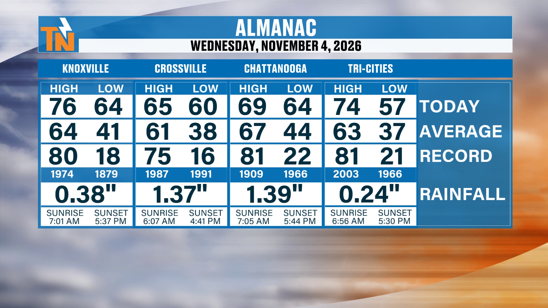
Let’s start you off with the almanac from yesterday.
We did make it into the mid to upper 60s, and even some mid 70s. So, not bad.
But look at the rainfall that we saw. Let me put this into perspective, because we saw a lot of rainfall.
How Much Rain Did We Get?
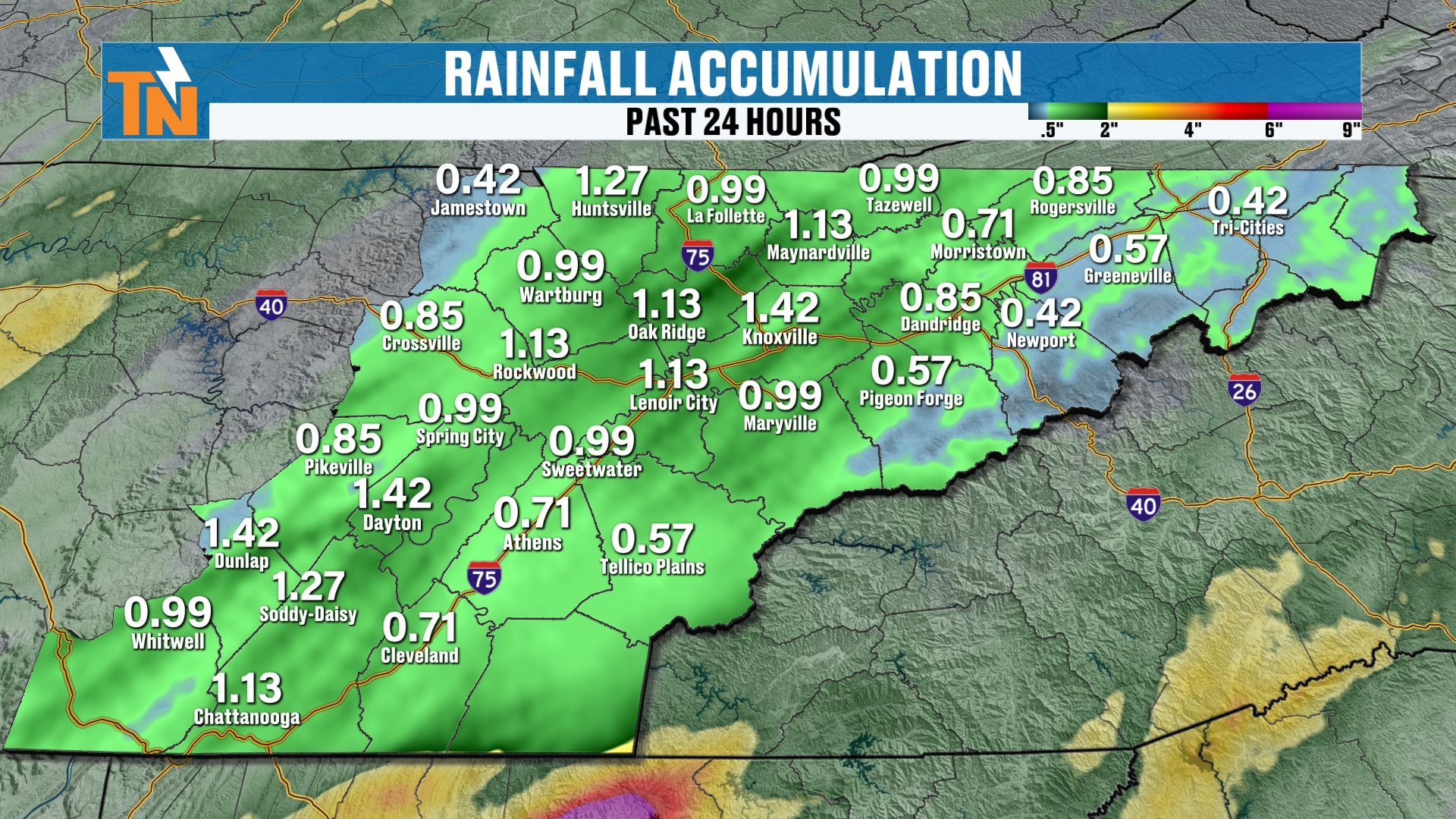
Everybody got some sort of rainfall.
There was a little bit less rain across the mountain counties, up from Sevier County through Greene County. That was due to the fact that we had those downsloping winds, and so we had a little bit of a rain shadow taking effect there.
We didn’t quite see it as much across the northern plateau either, in Fentress County.
But most areas picked up about an inch to an inch and a half of rainfall.
So it was definitely a beneficial rain. But again, with the clearing skies, that’s leading to some patchy dense fog, especially back to our west. If you have travel plans in Middle Tennessee, keep that in mind.
Radar Recap and the Fog
So here’s your radar recap.
We actually have some light showers still hanging out with us this morning. There is no severe weather this morning.
But notice the flood threat down across parts of Polk County and into northern Georgia. We have some flash flood warnings down there, where we’ve seen some heavier rain for sure.
The cooler and drier air is going to begin to settle its way in, and that’s going to be a process throughout the day today.
Let me expand the view a little bit. Our cold front is still continuing to swing its way through, and that’s why we’re hanging on to some showers this morning.
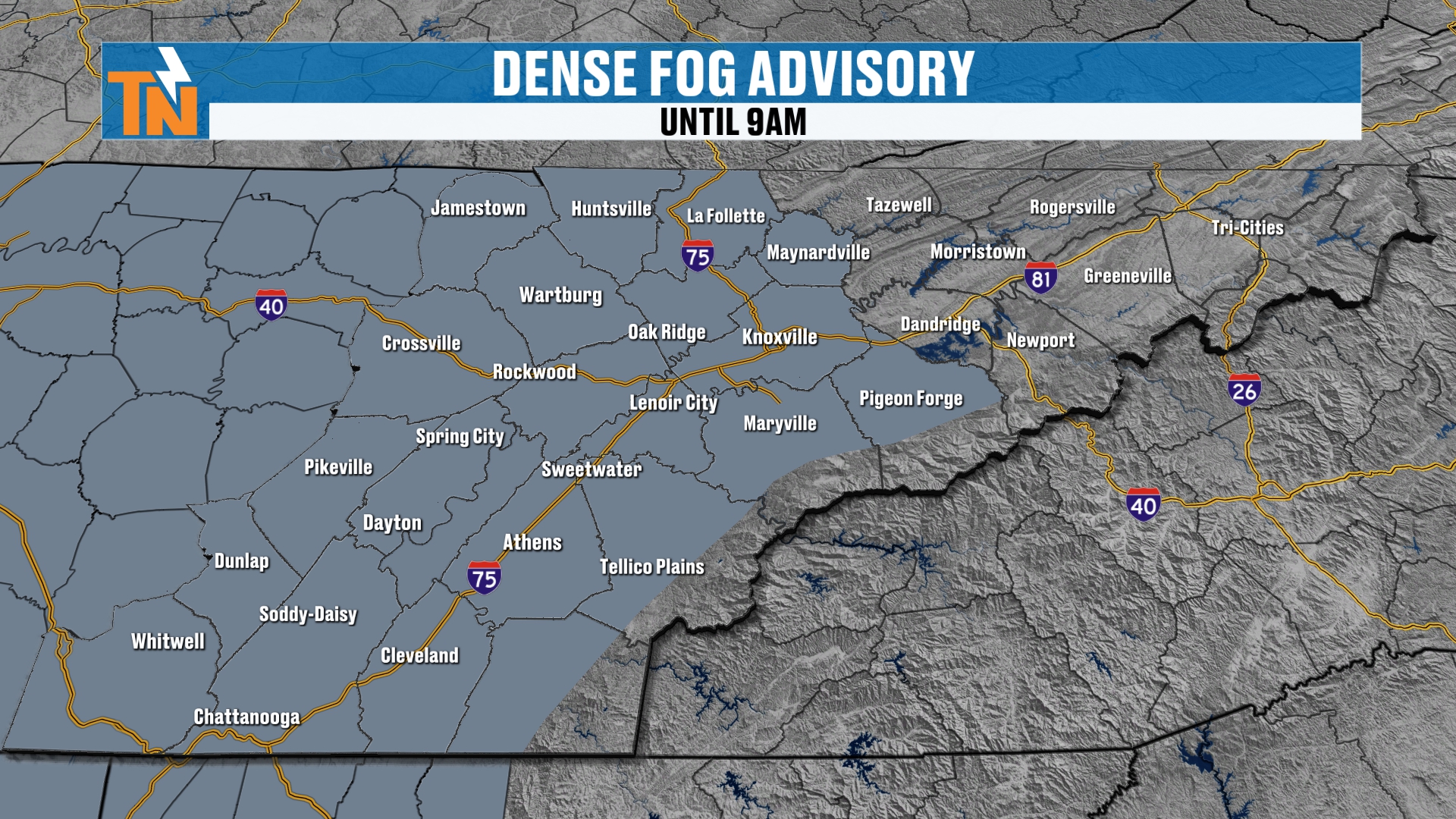
But back into Middle Tennessee, that’s where we have the dense fog. We also have some clearing back there. We’ve seen a lot more clearing, and that’s why the fog is a little bit thicker.
The National Weather Service has issued that dense fog advisory. I talked about that last night in my evening update: how much clearing do we actually see, and how much fog actually forms?
The best chance for some dense fog is further to our west. Visibility is going to be lowering as we get closer to sunrise.
The Pattern Change: Low Pressure and Upper-Level Energy
Now notice that low pressure system across the Great Lakes area.
There’s some upper-level energy that’s going to continue to dive its way through. That’s going to drop our temperatures as we get into the upcoming weekend.
But before we get there, we’re still talking about the potential for above-average temperatures today, and potentially a little bit tomorrow.
Then a secondary cold front swings its way through, and that’s going to bring us the cooler, drier air for the weekend.
But it doesn’t stop there. There’s another shot of even cooler and drier air as we get into the middle part of next week. I’ll explain the details on that.
And a quick note: it’s 0% chance of rain. The rainfall goes on out of here, due to the fact that we are continuing to see that dry air move in.
A Quick Note: Guest DJ on B97.5
We’re doing an early morning recording here because, well, I’m heading over to B97.5, the radio station, and I’m going to be a guest DJ this morning.
So make sure you tune in on your way to work!
Morning Temperatures: Not a Bad Start
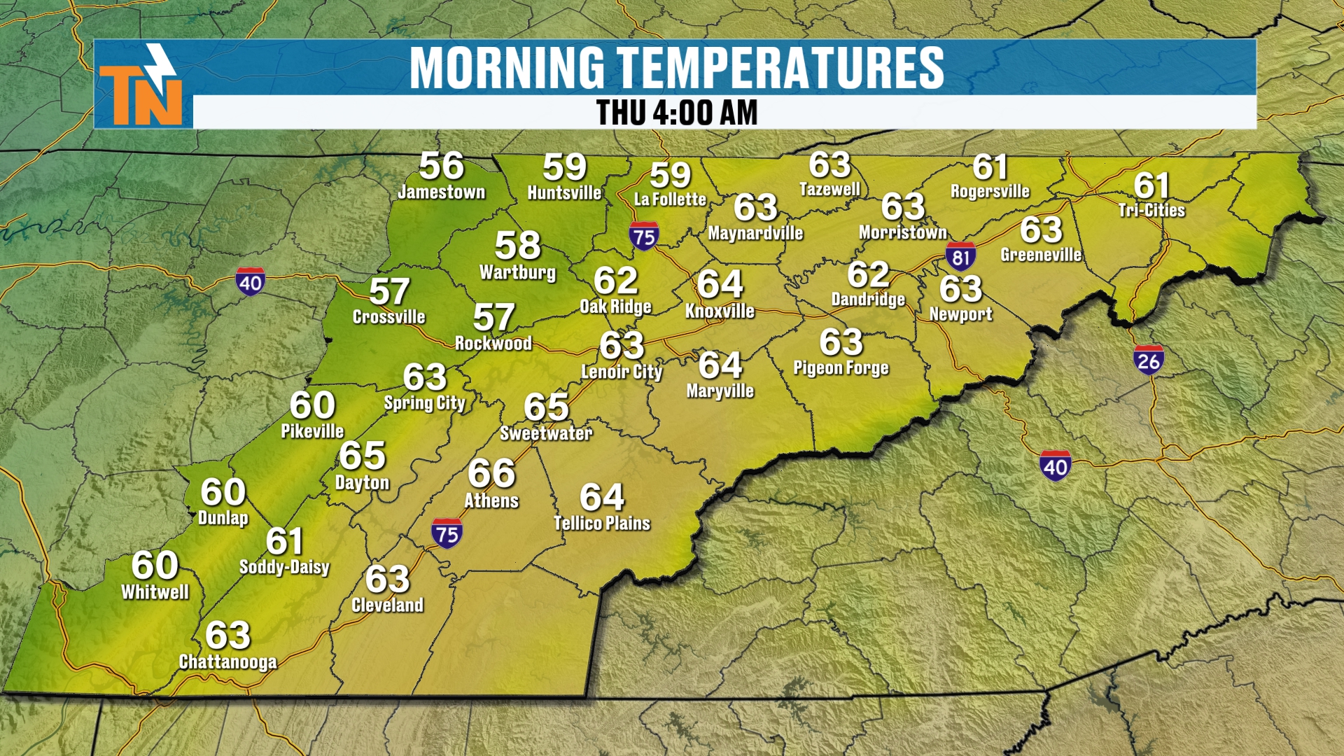
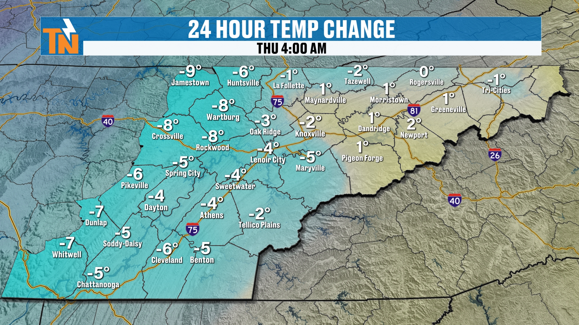
Temperatures this morning are starting off in the 50s and 60s.
Not a bad start. It feels pretty good outside. It is trending a little bit cooler than what it was yesterday, but it’s going to turn out to be a nice day.
Today's Forecast
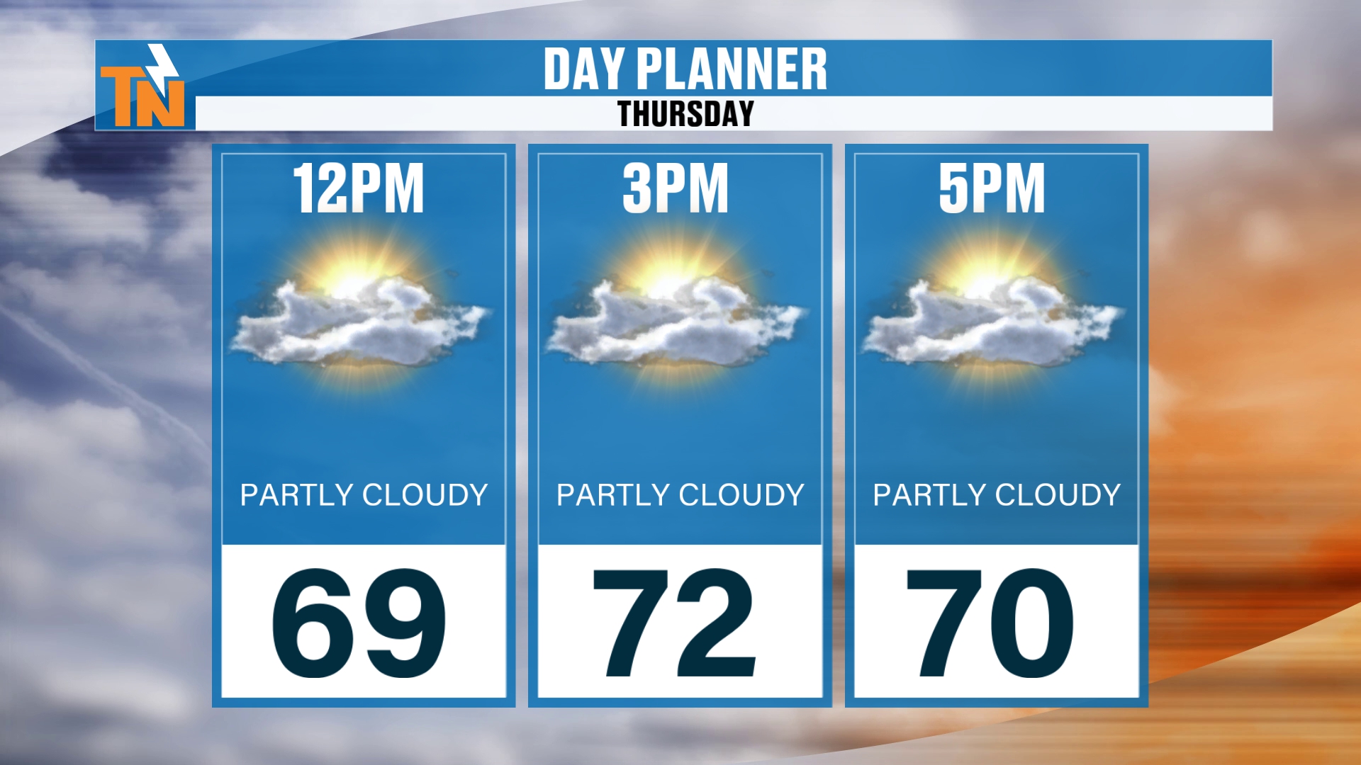
The skies will gradually clear, and we’ve got plenty of sunshine coming.
The fog burns off. We’re still probably partly to mostly cloudy at lunchtime. But again, that drier air is going to start to work in, shut down the fog, and clear the skies for much of the area.
The winds throughout the afternoon are going to be gusting to about 10 to 15 miles per hour. Not a big deal there.
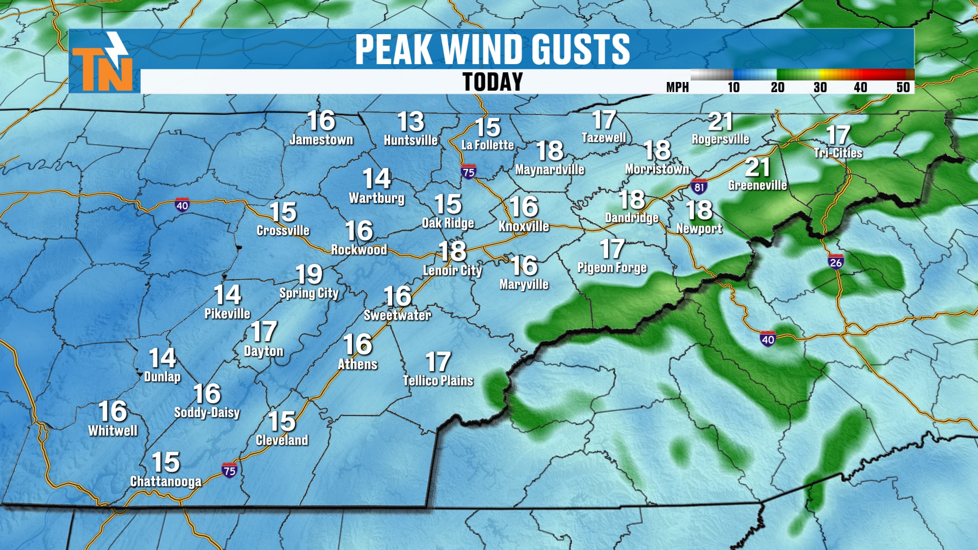
We’ll see a little bit higher wind gust across the mountains, and that’s a west-northwesterly wind, as we are now on the back side of that cold front.
Tonight
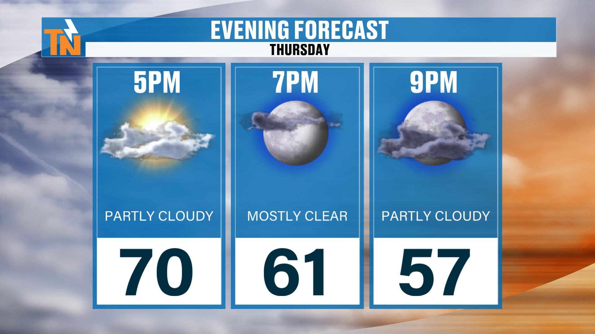
If you have evening plans, it should be a nice night.
We’re looking at 63° by 7 PM. Clear skies, and we should have a nice sunset across the area as well.
Setting Up the Pattern Change: The Timeline
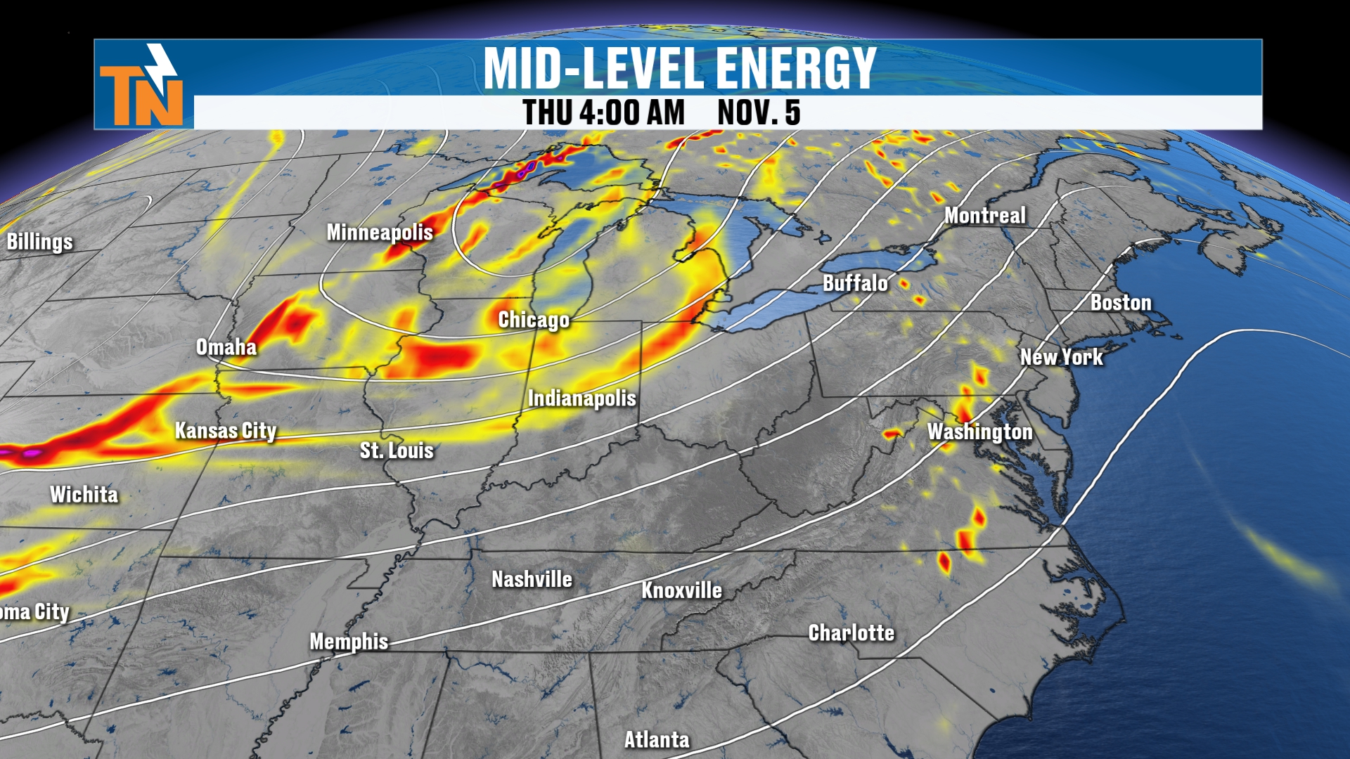
But remember, I said that low pressure and another piece of energy is going to be swinging its way through. Let’s pick up a timeline here, starting this morning, Thursday.
And there’s that upper piece of energy.
We’re going to stay on the warmer side today, due to the fact that the trough is still hanging back behind the cold front. But the trough is going to start to settle in.
So watch this. I’m going to keep the 500 millibar vorticity, which is spin in the atmosphere. I’m also going to keep the iso heights, which are the 500 millibar heights. That’s going to show you that deep trough coming through. I also have the surface map on there as well.
We’re going to see decreasing clouds and plenty of sunshine throughout the day today.
Friday: Clouds Increase and a Secondary Cold Front
Here comes that ball of energy. It’s going to swing its way into the area, and that’s going to increase our clouds throughout the day on Friday.
A secondary cold front comes through.
Now, I’m not necessarily thinking that we’re going to see a whole lot of rainfall. The energy and moisture on the back side of it is very shallow. But I can’t rule out maybe a stray light shower.
So some of those post-cold-front showers could come through on Friday.
I do have a 0% chance of rain on Friday. But I’m just going to throw a caveat out there and say maybe a couple of sprinkles or a stray shower can’t be totally ruled out. Does that make sense?
Either way, we are going to see the clouds increasing throughout the day on Friday as that comes through.
That’s also going to usher in the cooler and drier air. So, again, another shot of cooler air.
Saturday: Cooler and Much Drier
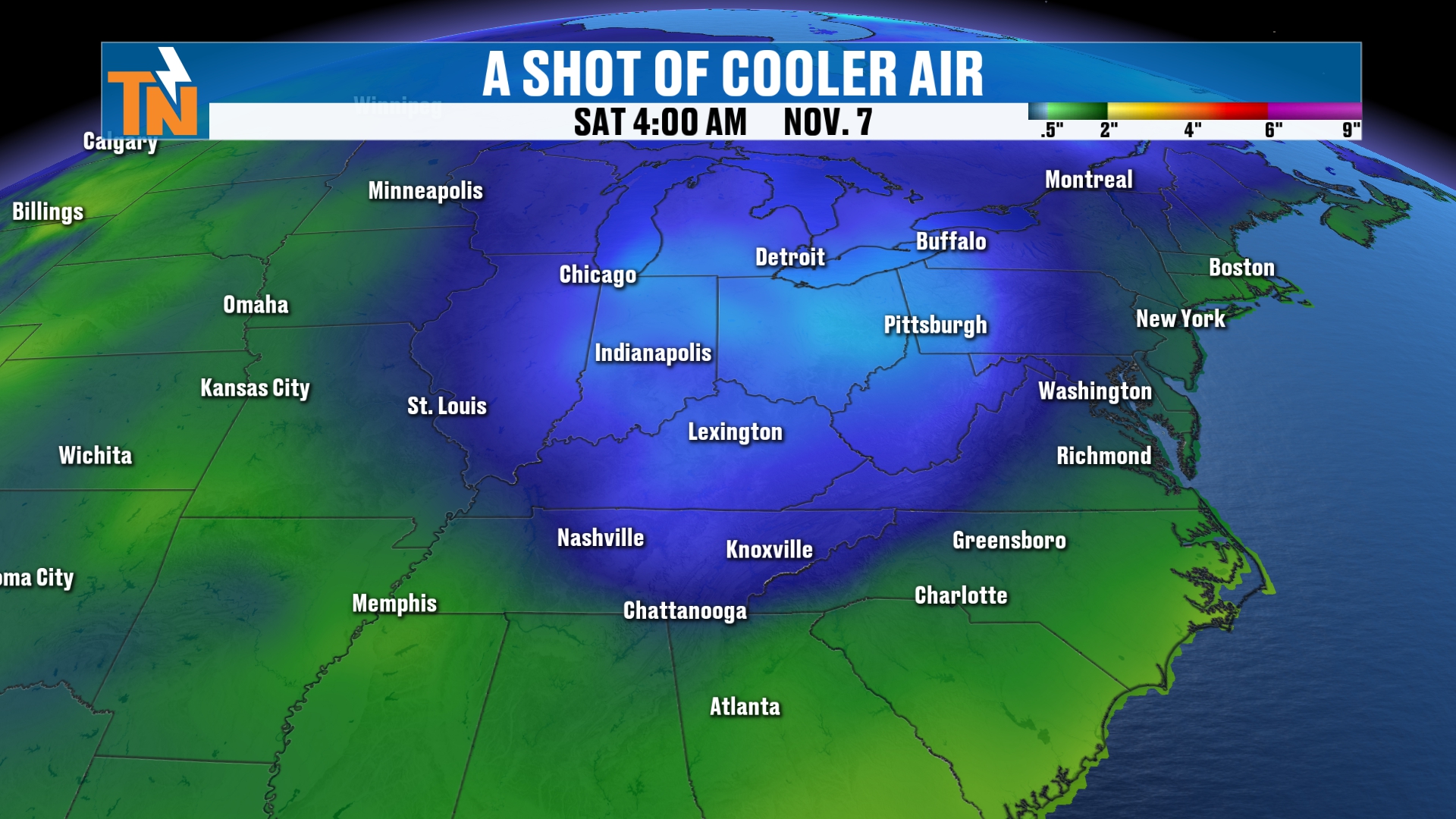
Here’s Friday. We’ll pick up our timeline going into Saturday.
Here comes that pocket of cooler air, that trough swinging in. And then it zips its way out of here, and we’ll start to see temperatures fluctuate back toward those seasonal averages.
But as I mentioned, it’s not just cooler air. It’s much drier air.
Dew Points Fall
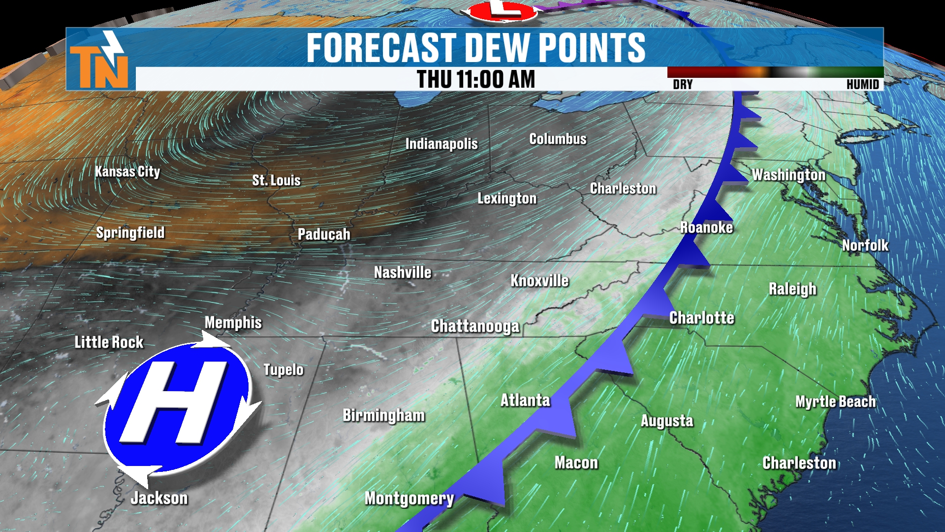
Look at how the browns are coming into the area. Those are going to drop our dew points.
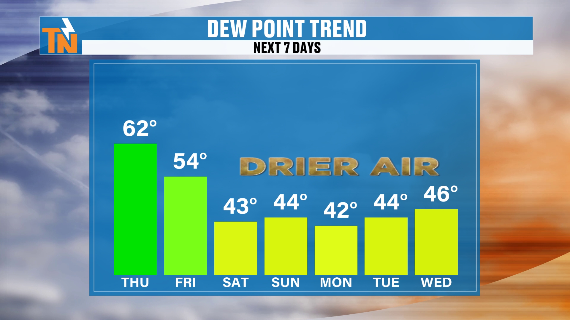
So our dew points fall this weekend, and that’s going to do a couple of things.
It makes the air feel great.
Static electricity goes up as the drier air comes in.
And that’s going to allow those morning lows to go down as well.
Chilly Mornings and Areas of Frost
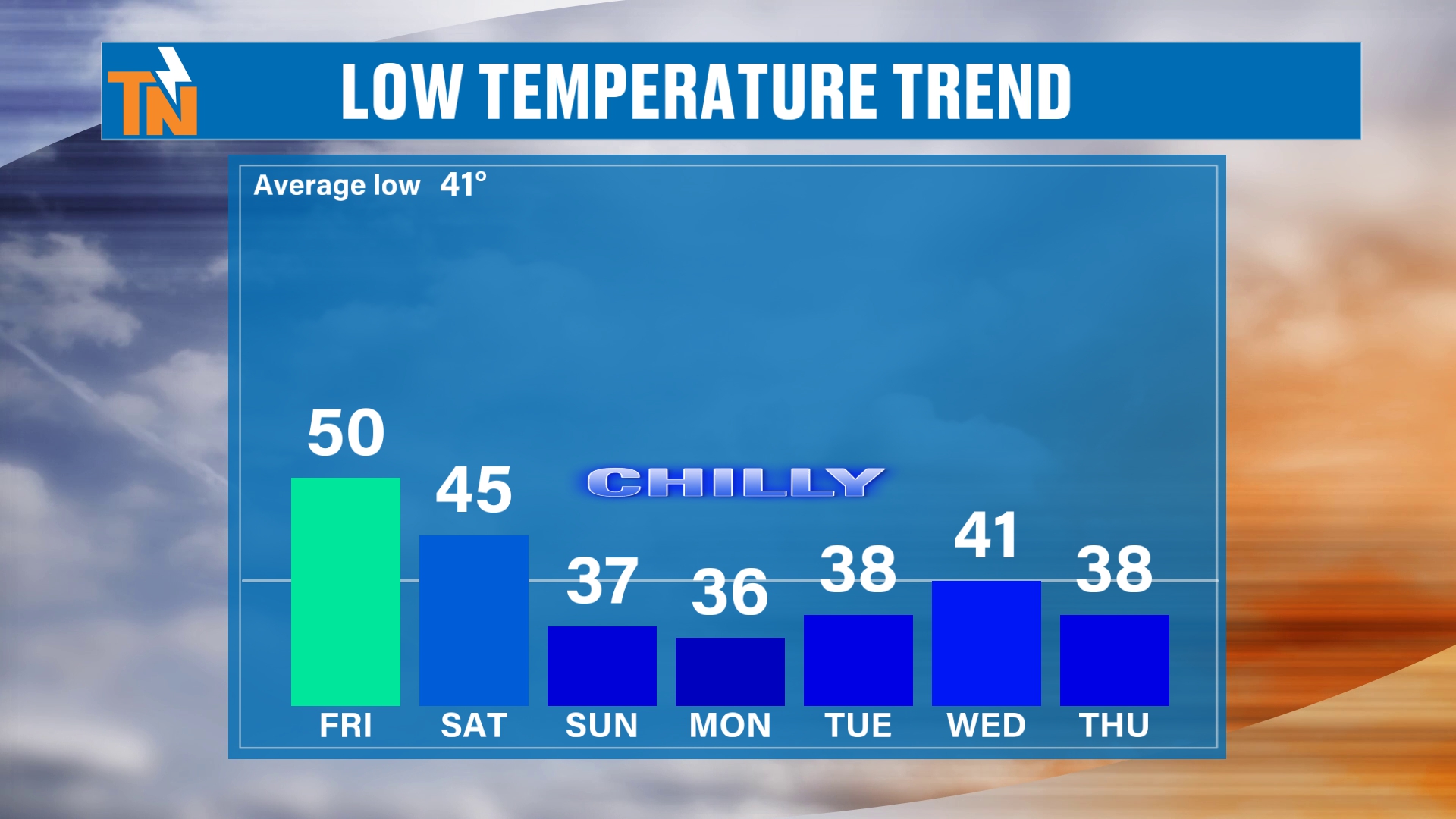
Tomorrow morning, our lows will be right around 50.
We’re down into the mid 40s on Saturday.
Then we’re going to have some areas of frost developing Sunday, Monday and Tuesday.
We’ll probably continue that trend on into maybe Thursday, Friday and Saturday of next week, because we have another piece of energy.
Another Piece of Energy Next Week
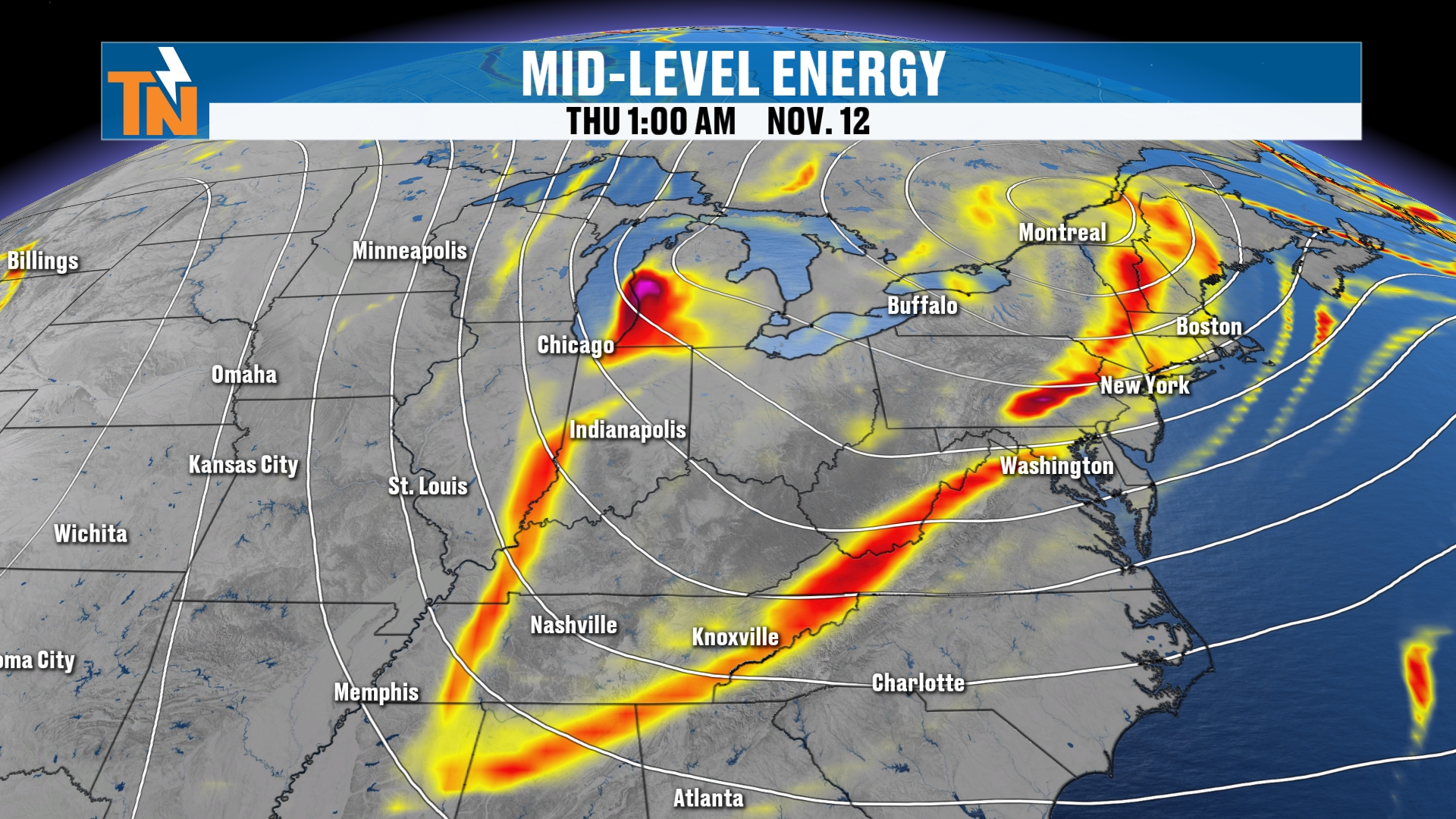
This is Wednesday, a week from yesterday. Another piece of energy is going to dive its way across the Northeast, which also is going to pull in some cooler and drier air.
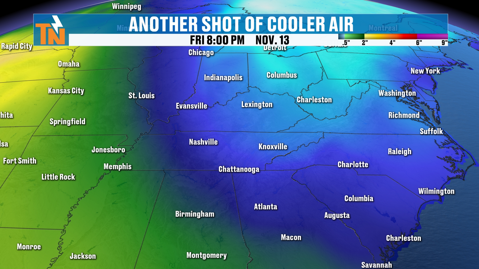
So dew points are going to continue to stay on the lower side. That’s going to give us plenty of sunshine, and again, dry weather.
We’re not looking at much in the way of rainfall.
What About the Long Range?
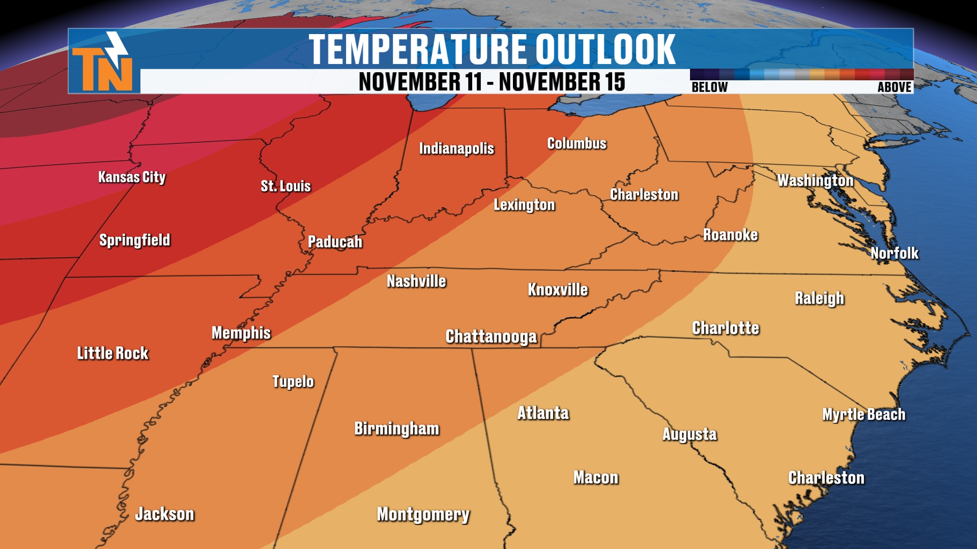
However, I want to show you this. This is a deterministic model, but when you look at the Climate Prediction Center forecast, they’re still predicting a potential for above-average temperatures.
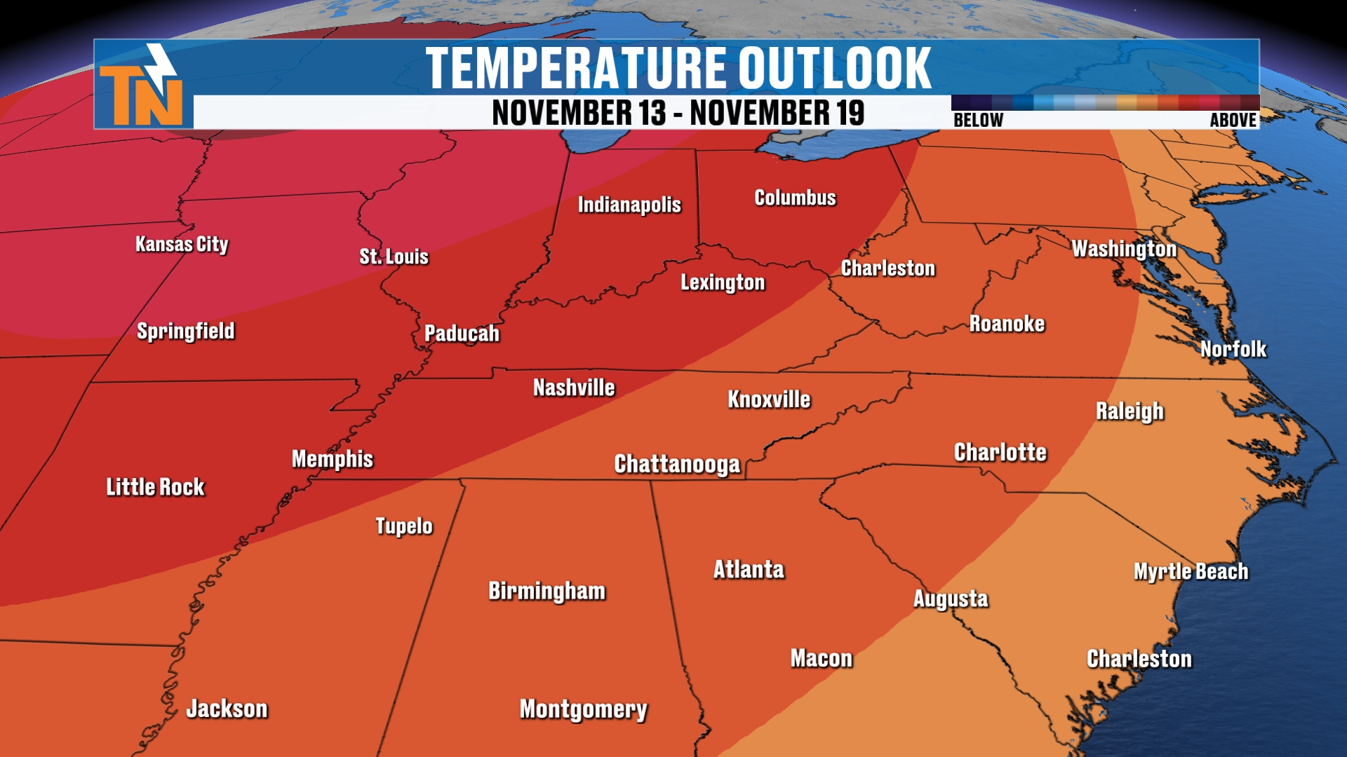
Now, of course, it’s a window, say between the 13th and the 19th.
But I actually think that as we get into the 11th and the 12th, we’re going to have that pocket of cooler air settling its way back in.
Your 7-Day Forecast
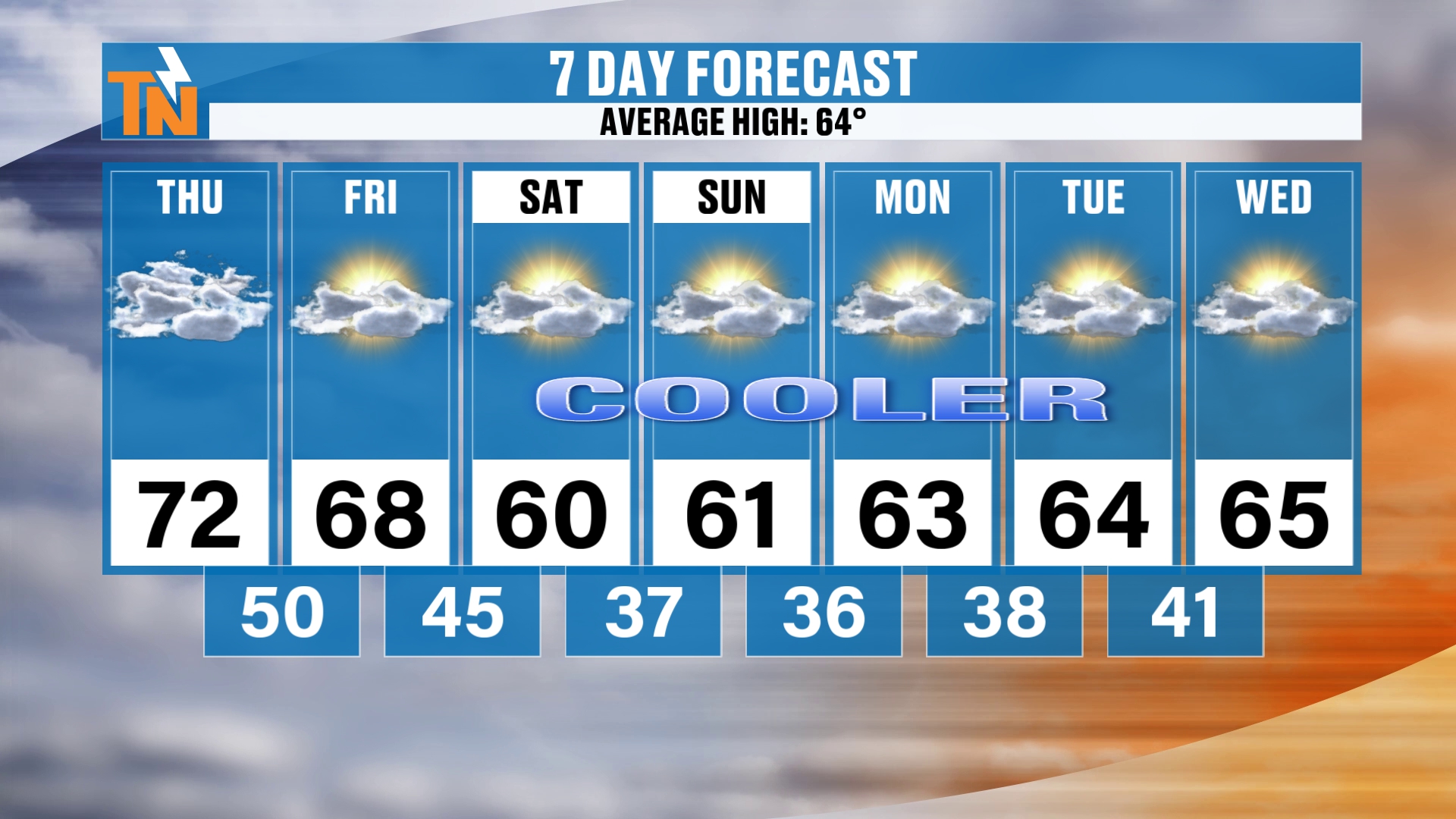
All right, here’s your 7-day forecast.
We’ll go 72 today, 68 tomorrow, and low 60s on Saturday, Sunday and Monday.
Then we’re back into the mid 60s Tuesday and Wednesday, and potentially even cooler and drier air settling in, which is also going to keep us on the dry side.
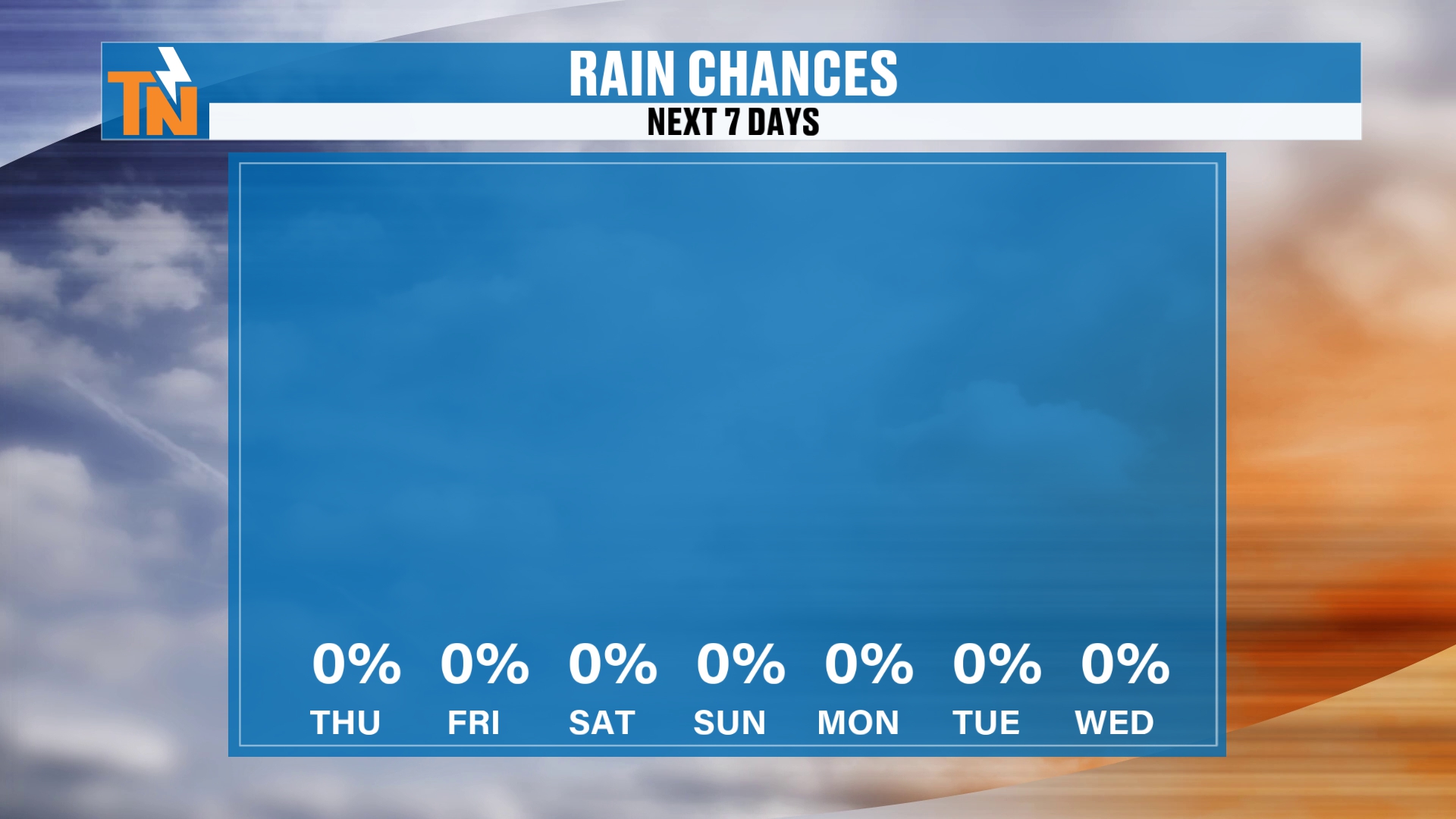
And look at those rain chances. Zero percent every day, Thursday all the way through next Wednesday.
Rain Outlook: Dry Is the Theme
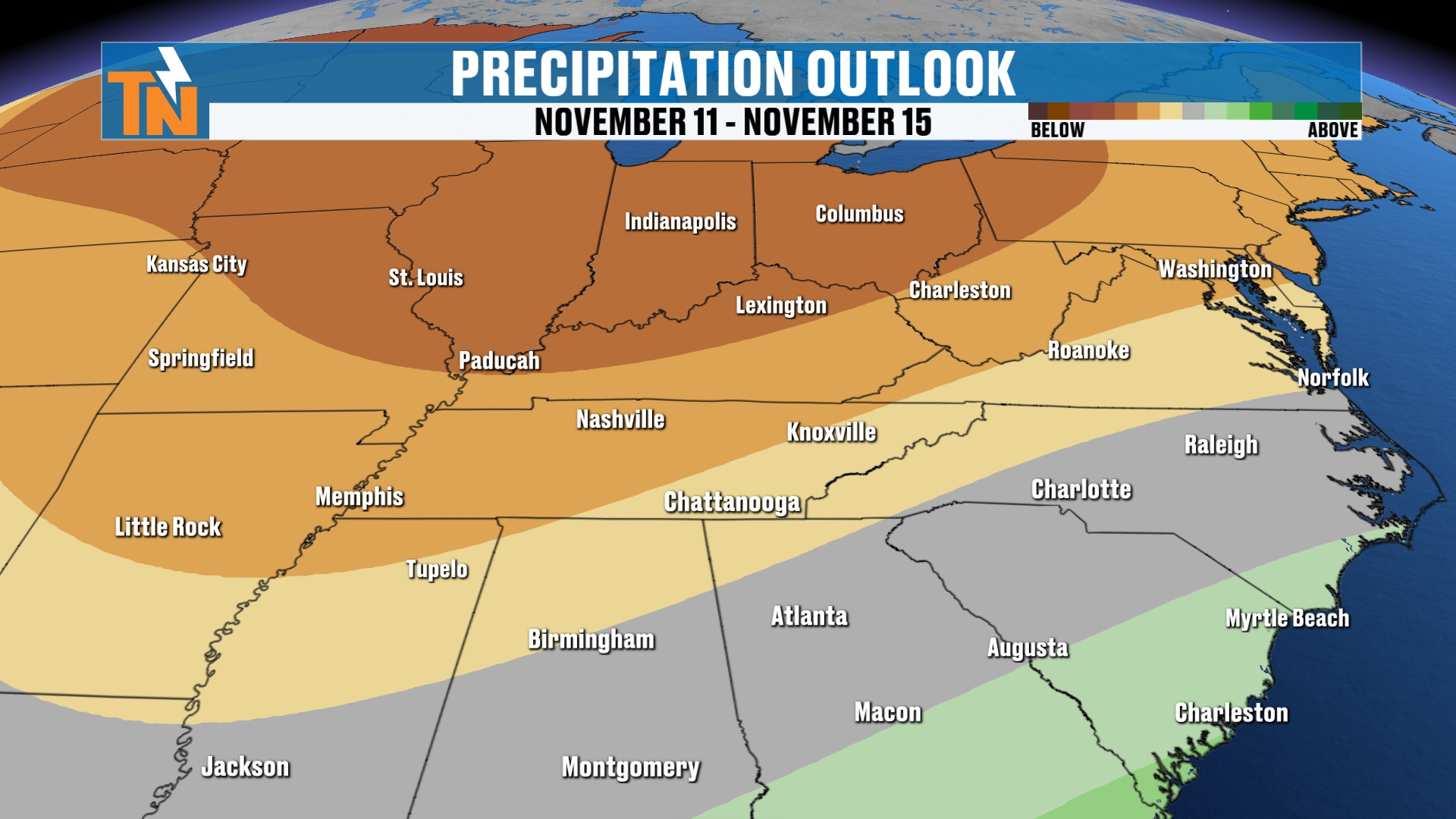
Your 6 to 10 and 8 to 14 day outlook by the Climate Prediction Center is still predicting below-average precipitation.
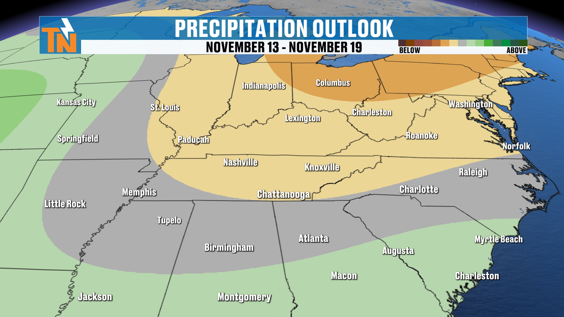
So not much in the way of rain.
We’re going to get a couple of shots of some cooler air. Temperatures will stay average to below average, and morning lows are going to be chilly with areas of frost developing across the area.
Bottom Line
THURSDAY: Patchy dense fog early, especially to our west in Middle Tennessee, with a few light showers still around this morning. Starting off in the 50s and 60s. Skies gradually clear with plenty of sunshine, and we top out around 72. Winds gust 10 to 15 miles per hour, a little higher across the mountains from the west-northwest. About 63° by 7 PM with clear skies and a nice sunset.
FRIDAY: A secondary cold front brings increasing clouds. The rain chance is 0%, but a stray light shower or a few sprinkles can’t be totally ruled out. A high near 68, with a morning low right around 50.
SATURDAY: Much cooler and drier as the dew points fall. A low in the mid 40s and a high in the low 60s.
SUNDAY AND MONDAY: Low 60s for highs, with areas of frost developing in the mornings.
TUESDAY AND WEDNESDAY: Back into the mid 60s, with frost possible Tuesday morning and another shot of cooler, drier air settling in around the middle of next week.
NEXT THURSDAY THROUGH SATURDAY: More frost is possible as another piece of energy dives across the Northeast.
LONG RANGE: The Climate Prediction Center is still predicting below-average precipitation. They have a window for above-average temperatures between the 13th and the 19th, but I think a pocket of cooler air settles back in around the 11th and the 12th.
So to recap: the pattern change is here. Today is still above average, then a secondary cold front brings the cooler, drier air for the weekend, and another shot comes in the middle of next week. Not much rain, and chilly mornings with areas of frost.
Don’t forget to LIKE, SHARE and SUBSCRIBE to this YouTube channel, and hit the bell so you’re always notified when I drop a new weather update. I do appreciate you sticking with me and learning a little more about the forecast and what I’m looking at in the long range.
Make sure you download my FREE eastTNweather app from your app store. It’s going to be quiet here for the next short while, but when the weather gets active like it did last night, it’s a good tool to have. You get lightning alerts, watches and warnings, and an interactive radar that gives you past, current and future radar. You can also find it on your smart TVs on Roku and Amazon Fire, and you can put this YouTube channel up there too. It’s weather all the time, and it’s family-friendly.
Because weather affects everybody. It’s the number one topic of conversation among adults, and it’s the one thing we all have in common.
Catch up on all of my recent daily forecasts anytime.
I’m Meteorologist Mike Witcher. Have a great Thursday!
eastTNweather — Weather When You Want It.