
Skip to content
eastTNweather logo
  • Weather
    • Daily Forecast
    • SkyCams
    • Map Room
    • Witcher’s Weather Watchers
    • Witcher’s Pictures
  • Education
    • Blog
    • Witcher Weather 101
    • School Visits
  • Shop
  • Contact
    • About eastTNweather
    • Advertise
    • Radio Stations
  • Donate
  • Weather
    • Daily Forecast
    • SkyCams
    • Map Room
    • Witcher’s Weather Watchers
    • Witcher’s Pictures
  • Education
    • Blog
    • Witcher Weather 101
    • School Visits
  • Shop
  • Contact
    • About eastTNweather
    • Advertise
    • Radio Stations
  • Donate
Watch Live
Severe Weather Alert Banner
Youtube Tiktok Facebook-f Instagram X-twitter

Category: Daily Forecast

THANKSGIVING WEEK TURNS ACTIVE! Rain Returns, Mountain Snow Possible?
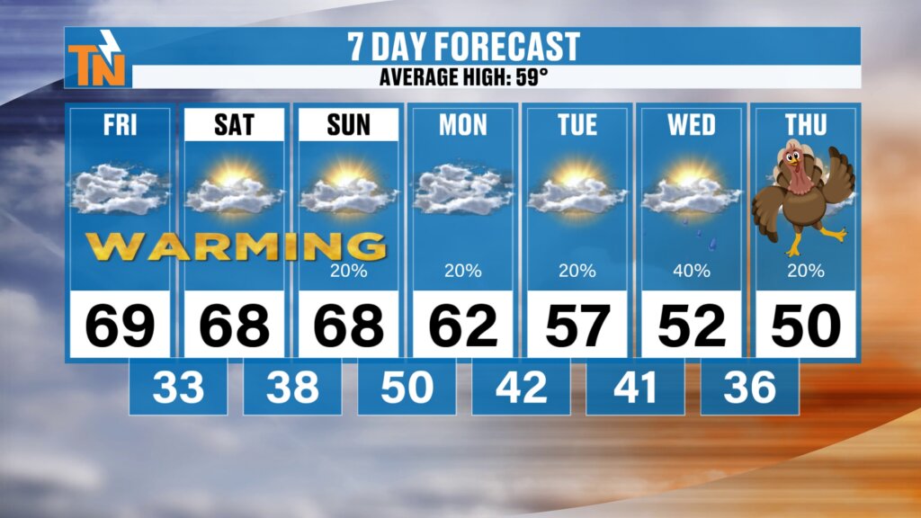
Seven day forecast with highs of 69 Friday, 68 Saturday and Sunday, 62 Monday, 57 Tuesday, 52 Wednesday and 50 on Thanksgiving Day with rain chances of 20 to 40 percent heading into Thanksgiving week

Thanksgiving week turns active with rain returning and a little mountain snow possible. Plus a warm Friday, football forecasts and your 7-day.

Is Our Storm Delayed? Less Rain, Better Travel Weather Ahead?
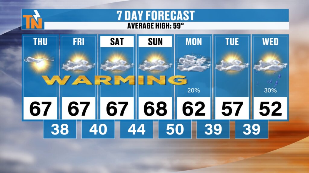
Seven day forecast with a warming trend from highs of 67 Thursday through Saturday and 68 Sunday, then 62 Monday with a 20 percent chance of rain, 57 Tuesday and 52 Wednesday with a 30 percent chance of rain

Is our storm delayed? Warm and dry through the weekend, a weak Sunday cold front, and a slower storm for Thanksgiving week travel. Here’s the latest.

DRY WEEKEND, WETTER HOLIDAY WEEK? Tracking the Next Storm Pattern.
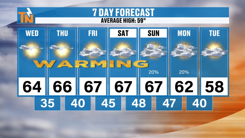
Dry weekend - DRY WEEKEND, WETTER HOLIDAY WEEK? Tracking the Next Storm Pattern.

A dry weekend is ahead with highs in the upper 60s. But Thanksgiving week looks wetter and more unsettled. See the rain, sleet and snow outlook.

THANKSGIVING SNOW SIGNALS? East Coast Storm Could Impact Holiday Travel!
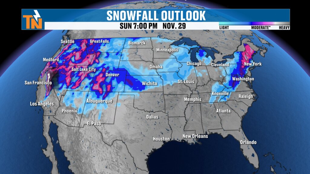
Thanksgiving snow signals in the snowfall outlook for Sunday, November 29 at 7 PM with snow across the Rockies, Plains, upper Midwest, the Appalachians and the Northeast

Fog and freezing fog start Tuesday, then a warming trend builds. Plus weekend rain chances and the first Thanksgiving snow signals for holiday travel.

TWO WEATHER SYSTEMS COULD MERGE! Rain Chances Return This Weekend.
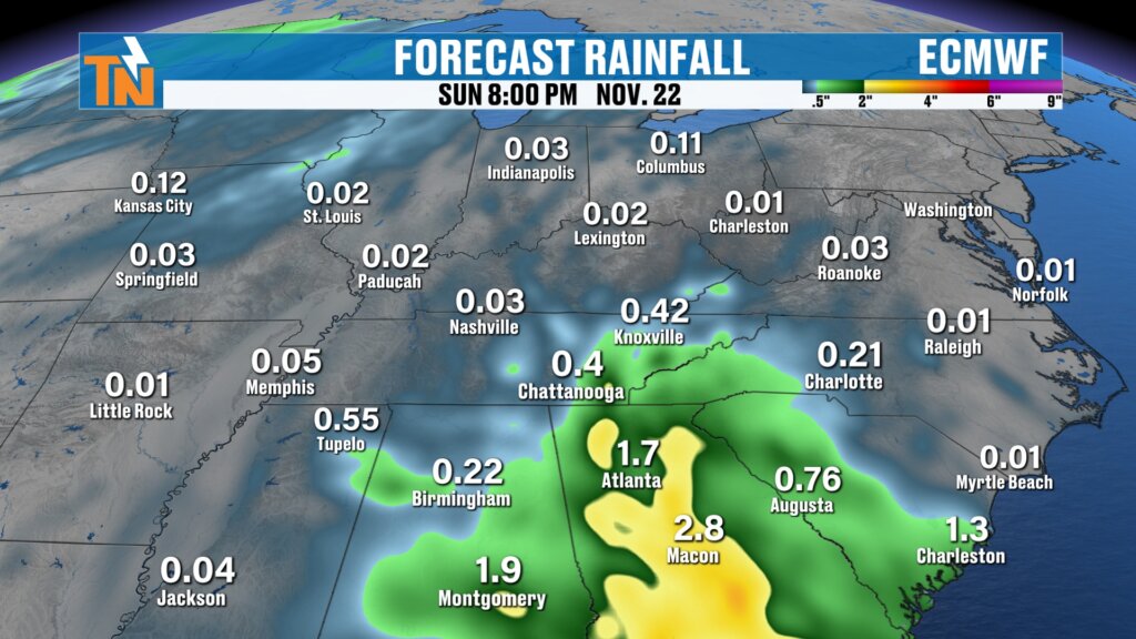
Two weather systems merging in the ECMWF forecast rainfall through Sunday, November 22 at 8 PM showing light rain around Knoxville and heavier rain across Georgia and the Carolinas as two weather systems merge

Two weather systems could merge near the Southeast this weekend, bringing rain chances. Plus a warm week and a first look at Thanksgiving travel.

BIG WARMUP AHEAD! But a Thanksgiving Trough Has My Attention!
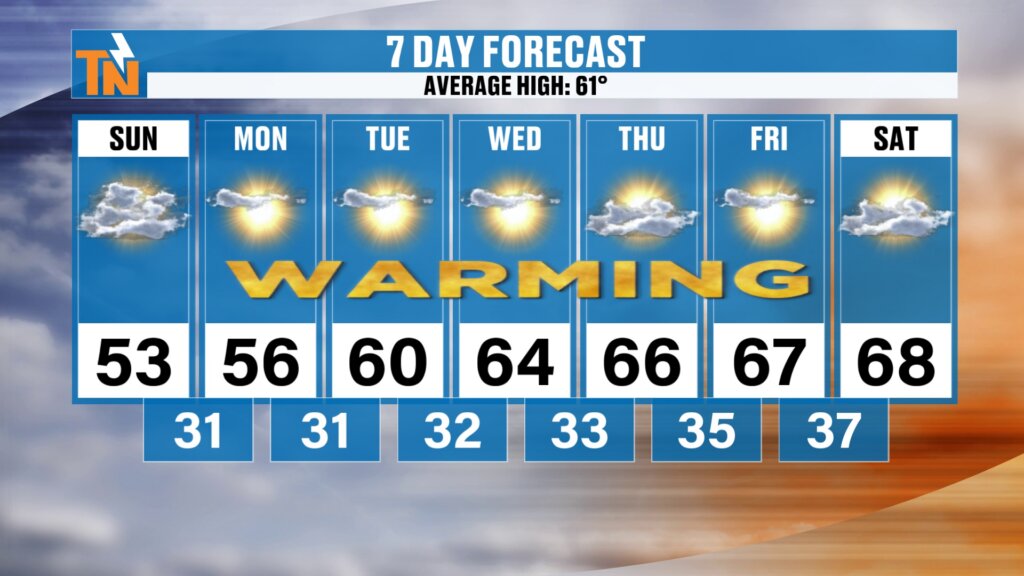
Seven day forecast with a warming trend from a Sunday high of 53 to 56, 60, 64, 66, 67 and 68 next Saturday and lows from 31 to 37

A big warmup is ahead with sunshine and quiet weather this week. But a Thanksgiving trough has my attention. See the rain and snow outlook for travel.

BIG WARMUP AHEAD! Plus Your First Thanksgiving Week Weather Outlook!
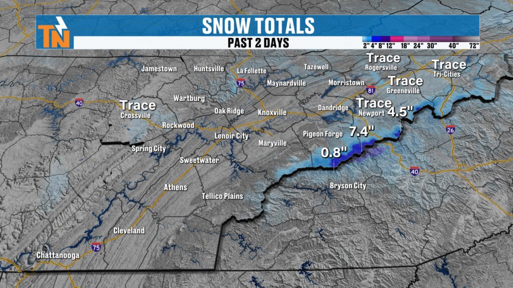
Snow totals for the past two days with 7.4 inches and 4.5 inches in the highest Smokies and trace amounts in the Tri-Cities and on the Cumberland Plateau

A big warmup is ahead after a chilly weekend start. See the Smokies snow totals, tonight’s hard freeze and your first Thanksgiving week outlook.

SNOW IS FALLING IN THE SMOKIES! More Tonight, Then a Hard Freeze
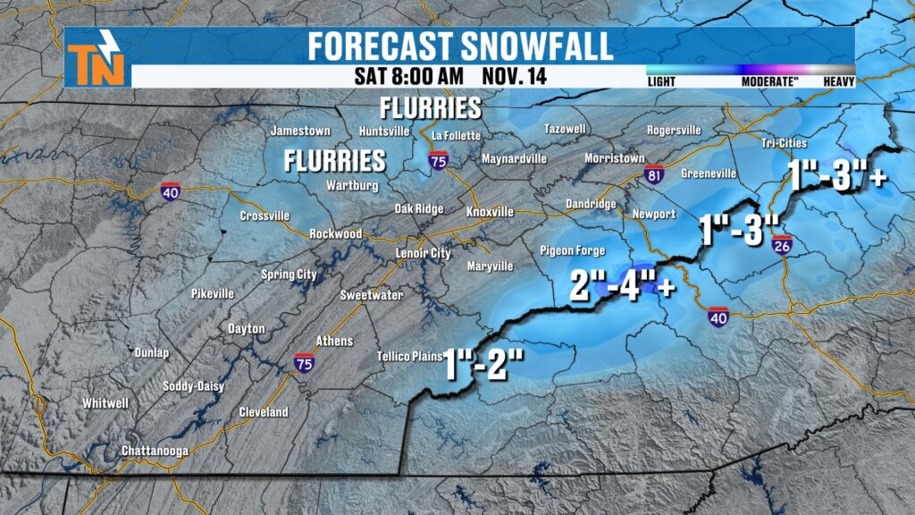
Forecast snowfall totals through Saturday morning with flurries on the Cumberland Plateau, one to two inches near Tellico Plains, two to four inches or more in the Smokies and one to three inches or more toward the Tri-Cities

Snow is falling in the Smokies, with more tonight. See snowfall totals, the advisory, Friday football weather and the hard freeze ahead.

MOUNTAIN SNOW ARRIVES! Who Sees Flakes and Who Sees Accumulation?
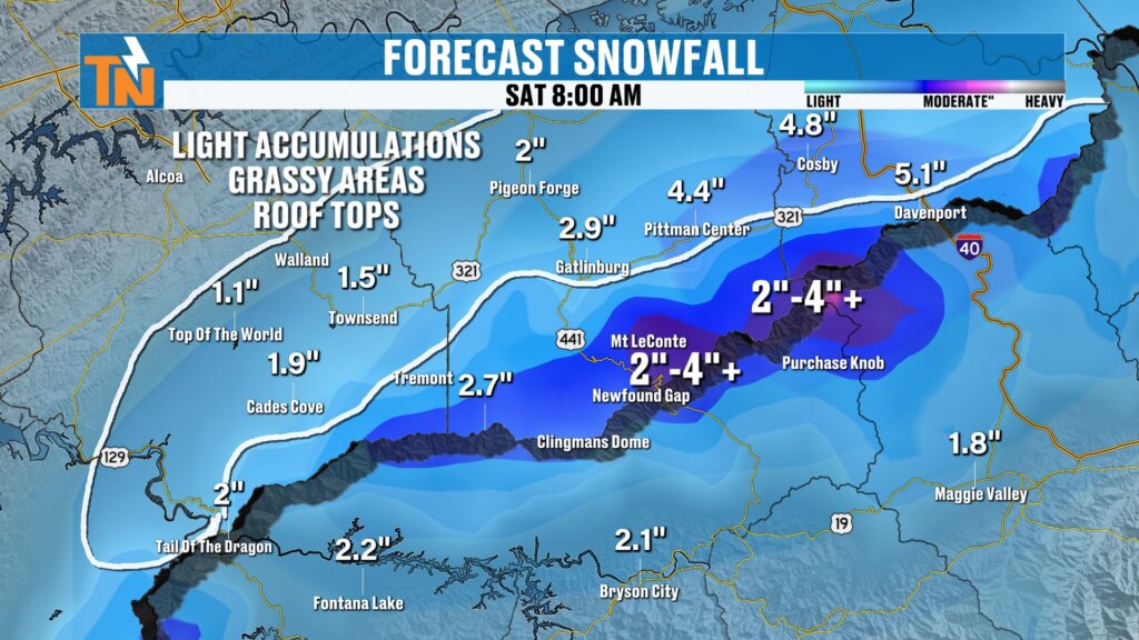
Official snowfall forecast for Saturday at 8 AM in the Smokies foothills with light accumulations on grassy areas and rooftops near Cades Cove, Top of the World, Pigeon Forge, Pittman Center, Gatlinburg, Cosby and Newport

Mountain snow arrives tonight as a winter weather advisory takes effect. See who gets flakes, who gets accumulation and when the hard freeze arrives.

OLD MAN WINTER ARRIVES! Mountain Snow, Flurries & a Hard Freeze!
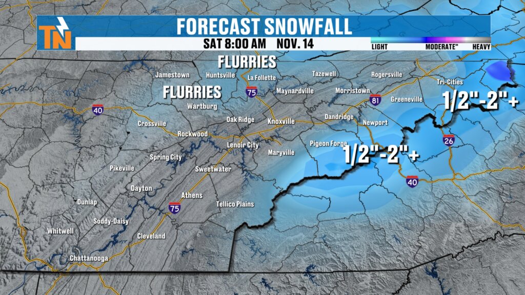
Official snowfall forecast for Saturday, November 14 at 8 AM with flurries across the Cumberland Plateau and one half inch to 2 inches plus in the Smokies

Old man winter arrives this weekend: mountain snow showers, flurries on the plateau and a likely hard freeze Saturday through Monday mornings.

Next →
eastTNweather logo
Youtube Tiktok Facebook-f Instagram X-twitter
Daily Forecast
SkyCams
Advertise
About
Knoxville Weather
Tri-Cities Weather
Smoky Mountains
Forecast Archive

Download Our App

and stay up to date on the latest weather updates

Download eastTNweather on the Apple App Store
Get eastTNweather on Google Play

Also available on

Amazon Fire TV
Roku
eastTNweather weather app on a phone
©Copyright, eastTNweather. | Website design by: Epic Nine. | Privacy Policy