
Published: Friday, November 6, 2026 | By Meteorologist Mike Witcher | eastTNweather
Good morning, East Tennessee, and happy Friday! This is your morning weather update on this November 6th, 2026, and another cold front arrives today.
It’s a secondary cold front, and it’s going to swing its way through and bring us a batch of clouds. It’s also going to drop our temperatures as we get into the upcoming weekend. Not just the highs, but the lows too.
It’s going to be a fantastically cooler weekend. More Novemberlike, if you will.
We’ve got a high school football forecast for tonight, the UT football forecast for Saturday, and the bigger story: the long range. What’s down the pipeline? Do we have colder air? Do we have any rainfall on the way? And what does it look like for frost this weekend?
Spoiler alert: we are going to see some frost developing across the area this weekend. Let’s walk through all of it.
Yesterday's Almanac
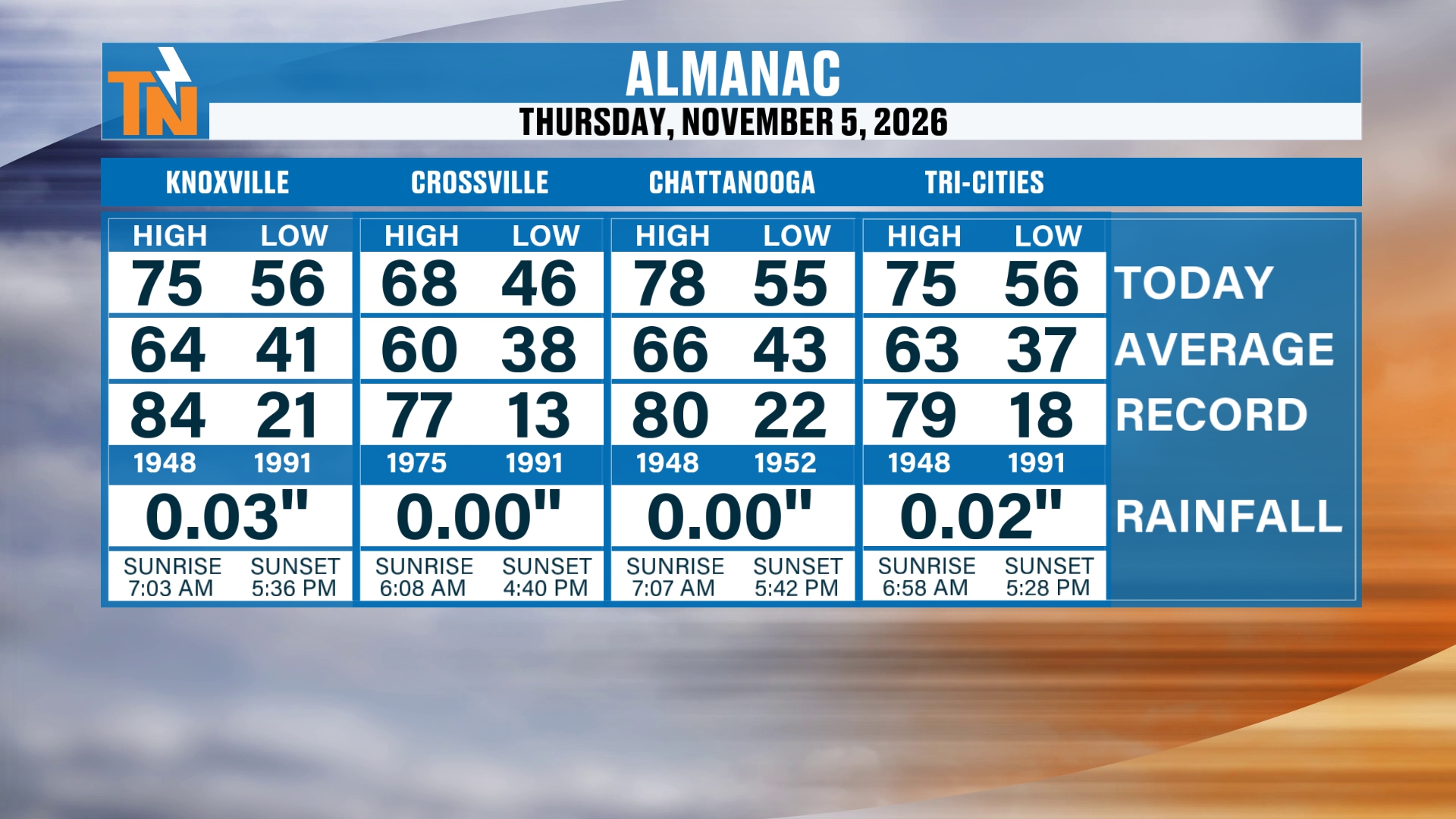
Let’s start with the almanac from yesterday.
We topped out in the upper 60s and mid to upper 70s. So it was definitely on the mild side, and above average. Averages, again, are in the mid 60s.
But here comes our weekend cold front.
Another Cold Front: Clouds and a Little More Breeze
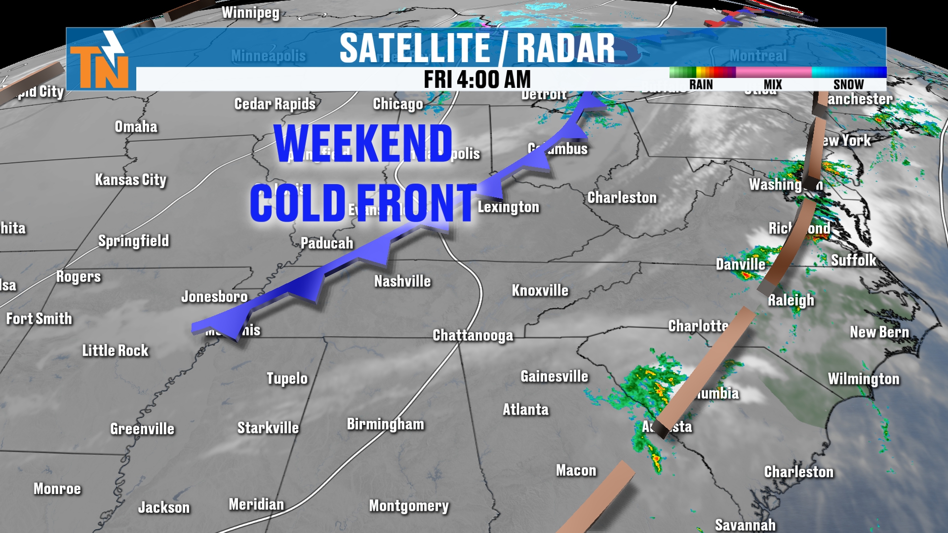
Here’s the weekend cold front. It’s just off to our north to northwest.
It’s a dry cold front, so I’m not expecting much in the way of rain. But it is going to bring us a little bit more of a breeze.
It’s tough to see on the satellite and radar imagery in this view, anyway, but it is going to bring us a batch of clouds as we progress through the day.
So here’s how today is going to play out. We start off with plenty of sunshine and a little bit of fog as well. Once the fog burns off, we get plenty of sunshine.
But as we get into the lunch hour, you’re going to start to see some clouds filtering into the area. That gives us that filtered sunshine, overcast, kind of gray look.
These clouds are going to be a little bit lower in elevation, about 5,000 to 6,000 feet. They don’t have a lot of vertical development, so we’re not necessarily looking at much in the way of rainfall.
Can I rule out maybe a sprinkle here or there? No, I can’t necessarily rule that out. But that’s likely not the case.
Morning Temperatures: Cooler Than Yesterday
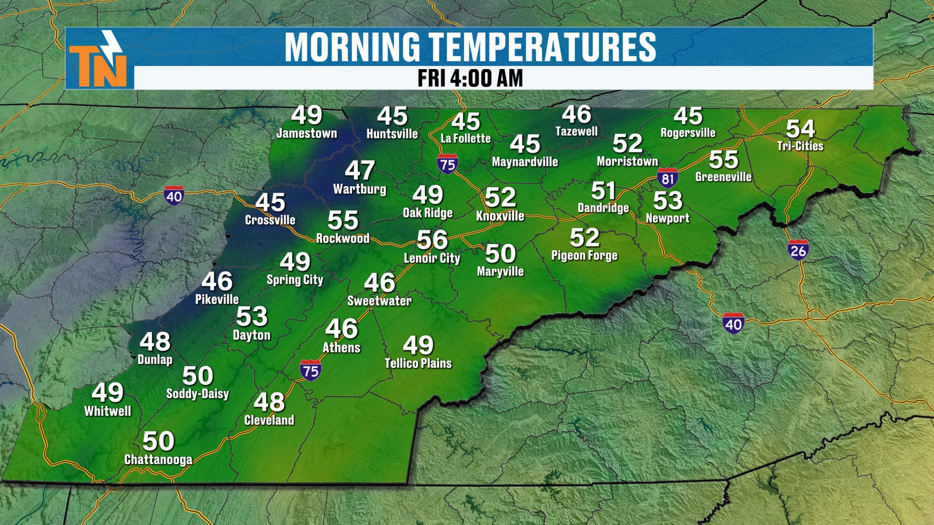
Temperatures this morning started off in the 40s and the 50s.
Technically, that’s much colder than what we were yesterday.
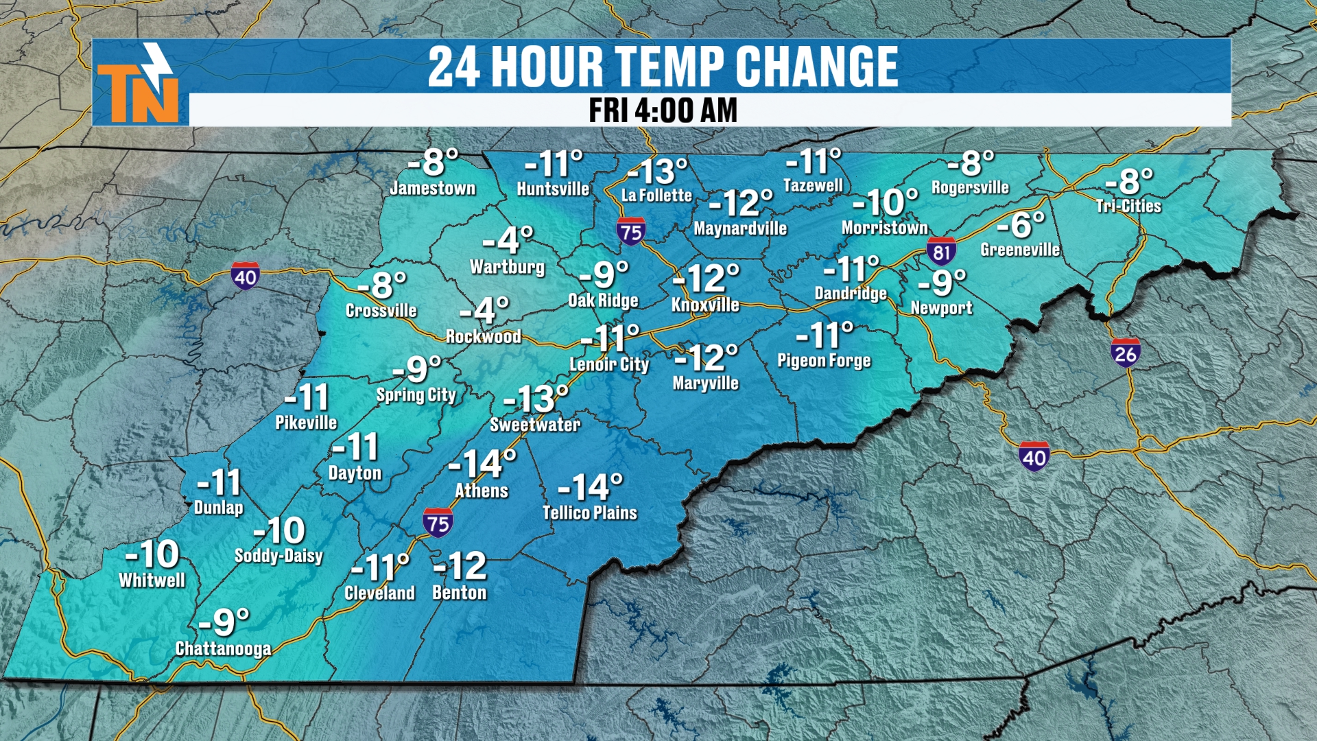
How much colder? About 5 to 10 degrees or so across much of the area, and a little more than that in some spots.
Today's Forecast: Sun Early, Clouds Later
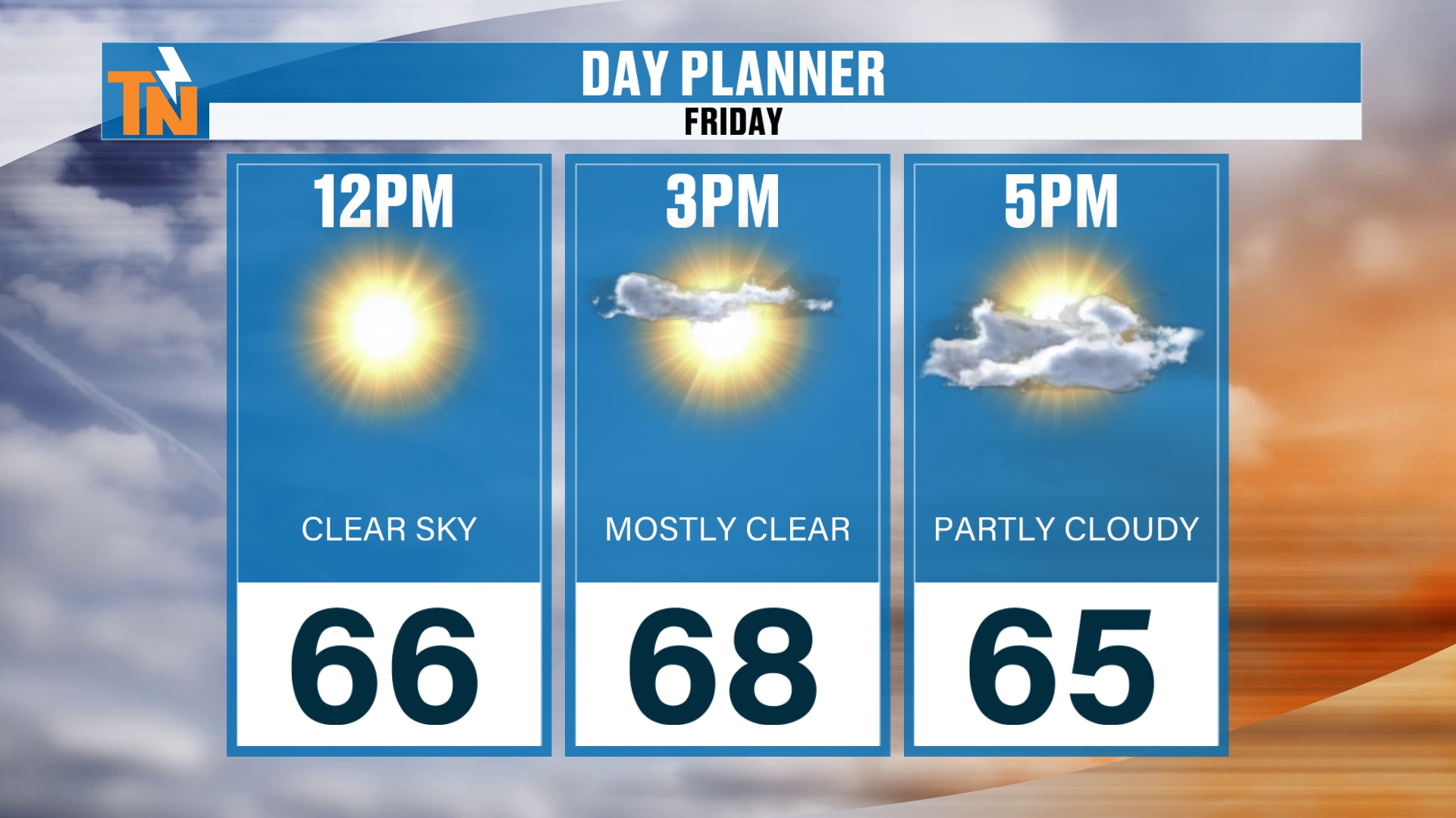
By lunchtime, we’re going to warm back into the mid 60s. It’s going to be fantastic.
For the kids heading home from school, we’re going to be in the upper 60s to low 70s. So we’re still technically trending above average.
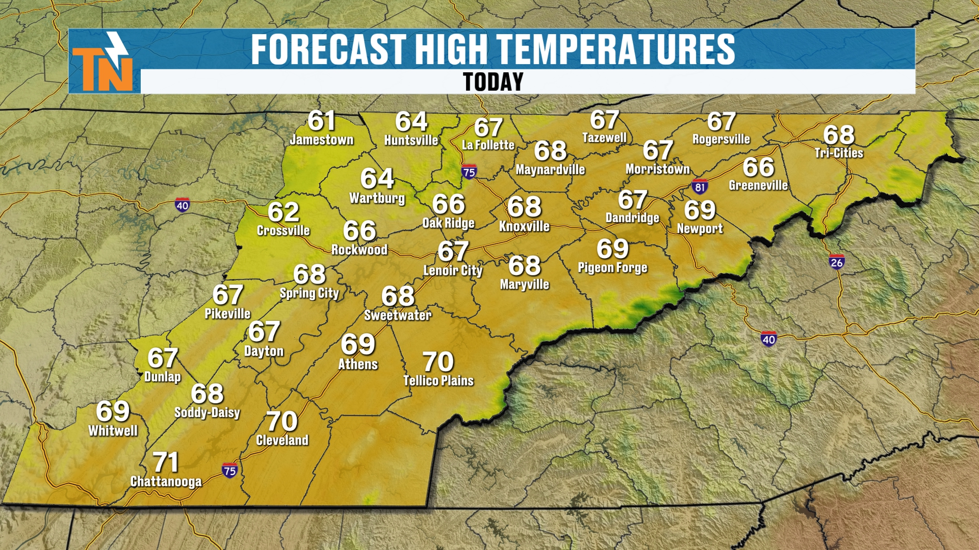
I’m going about 69 degrees in and around the Knoxville area.
The wind is going to pick up as well, gusting to about 15 miles per hour, and maybe a gust up to about 20 at times. I think you’ll notice when that cold front comes on through, because the winds can start to kick up. That’s going to be later this afternoon into the early evening hours.
High School Football Forecast: Good Luck, Panthers!
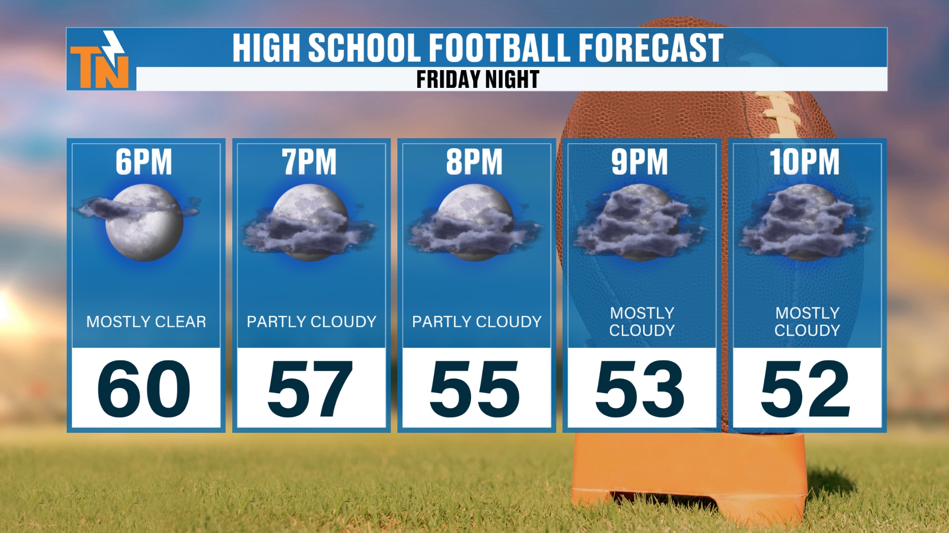
If you’re heading off to high school football tonight, we’re going to have that batch of clouds hanging out with us. By 7:00 tonight we’re mostly cloudy, and those clouds will be with us all the way through Saturday morning. Then more sunshine returns throughout the day on Saturday.
By 6:00 we’re right around 60 degrees. Down to about 55 by 8:00.
If you’re still out and about by 10:00, we’re down to about 52 degrees.
I’m going to be doing the Jumbotron forecast for Powell High School, so good luck to the Panthers here tonight!
The Setup: Mid-Level Energy
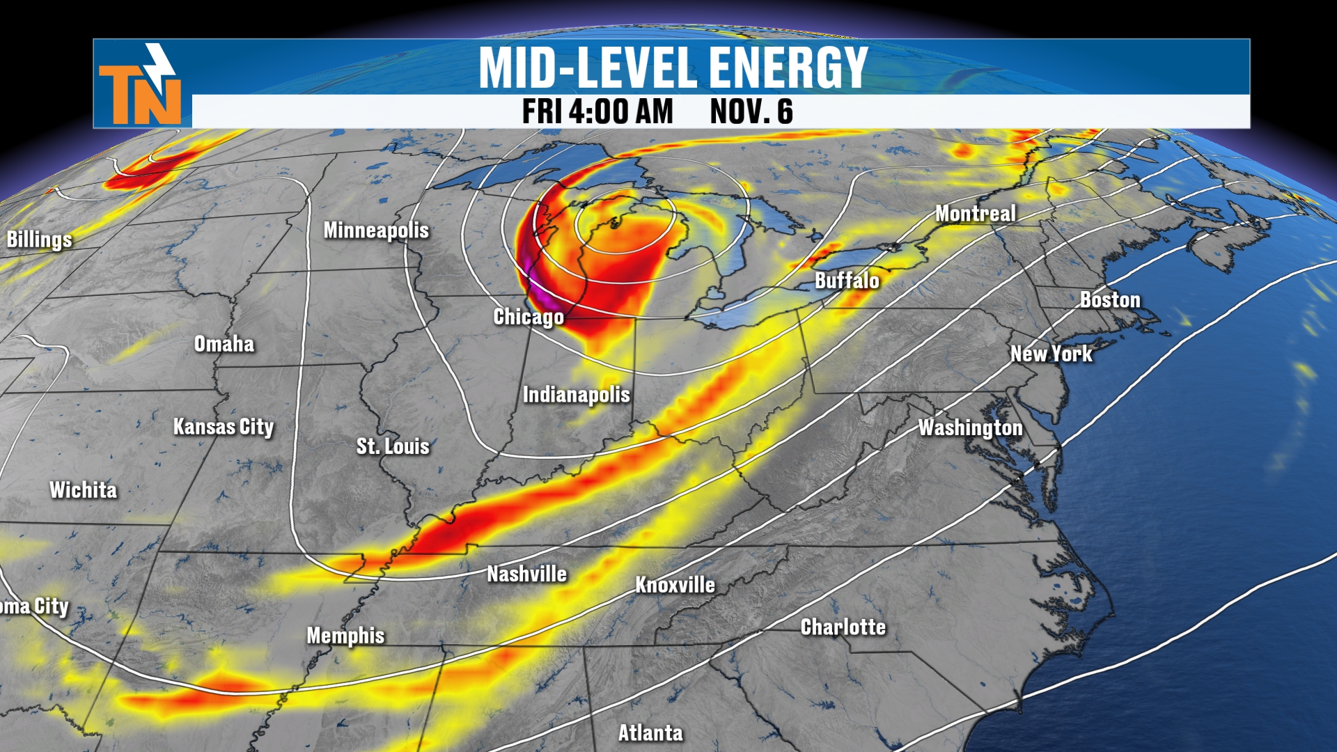
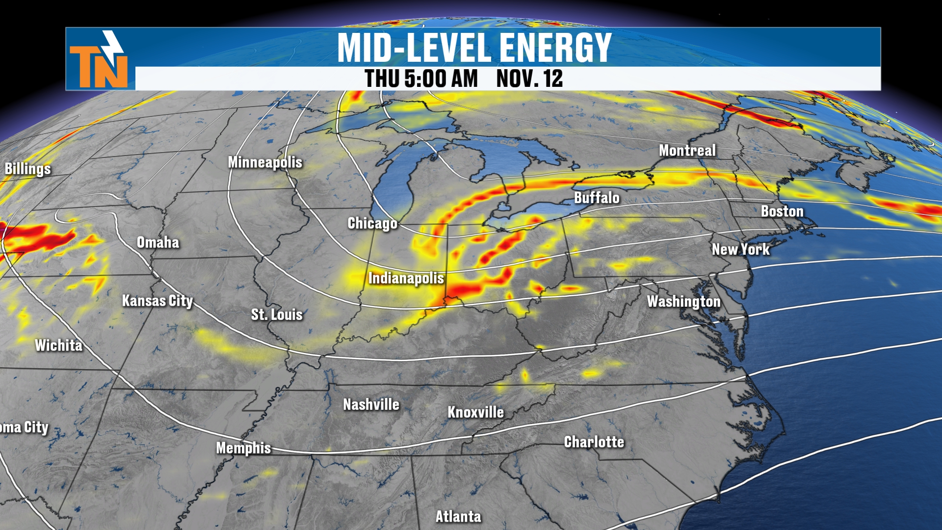
So what’s pushing this through? That’s mid-level energy. This is that trough that’s coming on in.
That’s what’s pushing the cold front through, and that’s what’s going to bring us the batch of clouds as we head through the afternoon. It’s that upper-level piece of energy off to our north.
Tonight's Lows
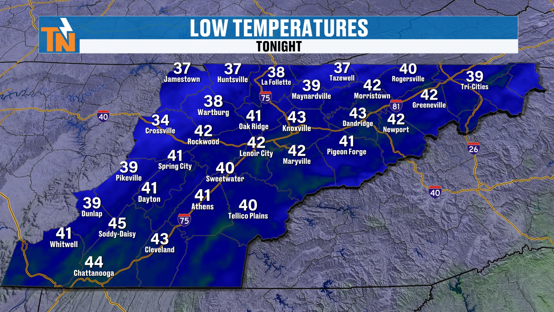
Low temperatures tonight are where this gets interesting.
Because this trough is coming through, it’s going to start to drop our temperatures. It also brings us even drier air than what we’ve had out there over the last couple of days.
That’s going to allow our morning low temperatures to drop into the 30s and low 40s on Saturday.
But that’s not the coldest weather that’s going to come through. That comes as we get into Sunday, Monday and Tuesday, and really across the 7-day stretch after tomorrow morning.
UT Football Forecast: A Chilly Game
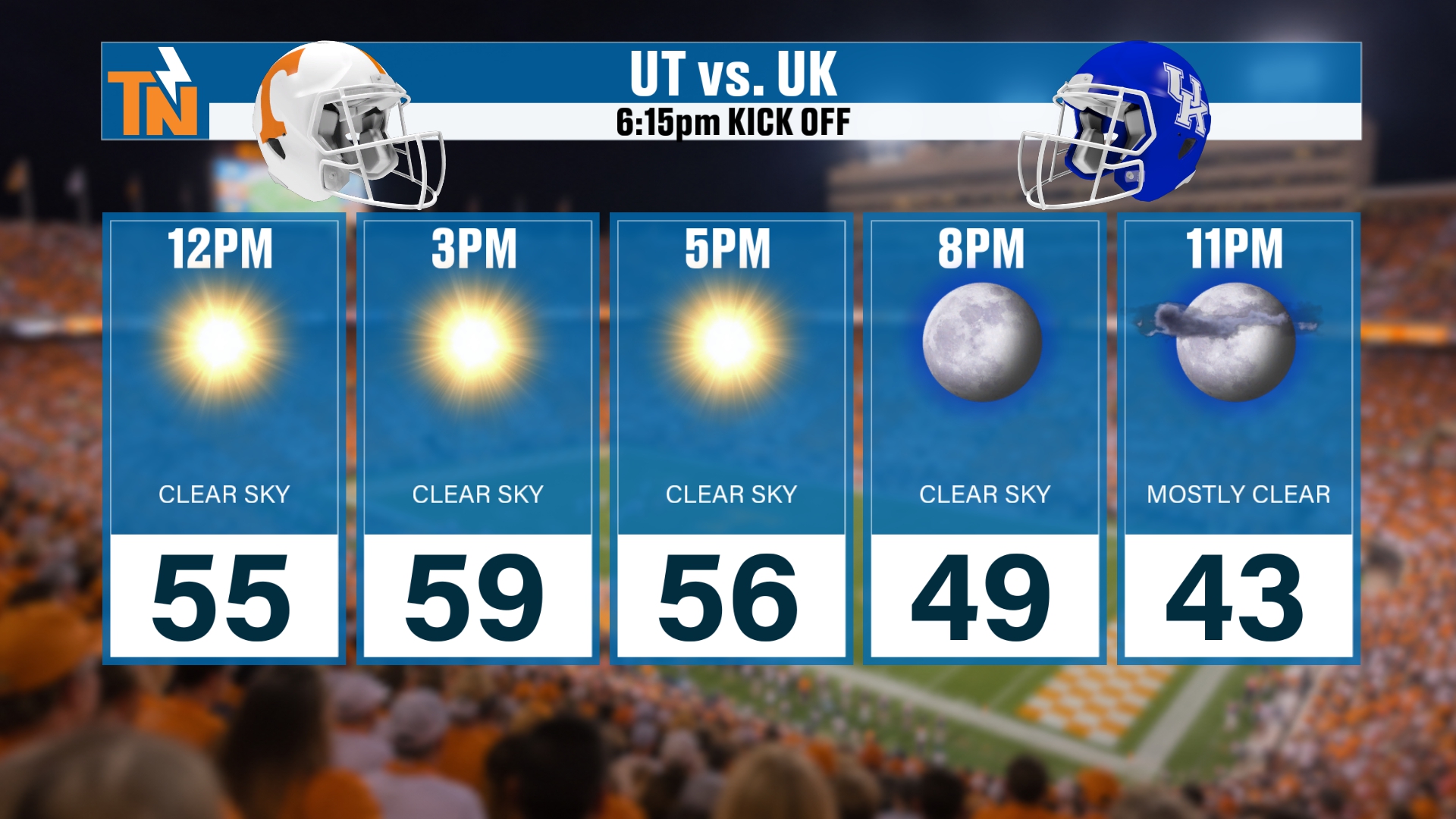
By the way, if you’re heading off to the UT football game tomorrow, morning low temperatures are in the 30s and 40s, and we’re going to see those temps climb back into the 50s.
So it is going to be a chilly game. Kickoff is at 6:15, and look at those temperatures. We’re going to drop down into the low to mid 40s as we get toward and into the football game.
You’ll want the sweatshirts and the jackets.
A Quick Note: Radio With Roger on B97.5
If you heard that alarm, that was my alarm, because I have to hit the road here in just a little bit.
I’m heading back over to the B97.5 studios to be the guest fill-in with Roger. So make sure you tune in to B97.5 this morning. I’ll be over there broadcasting with Roger!
Saturday: Breezy and Cooler
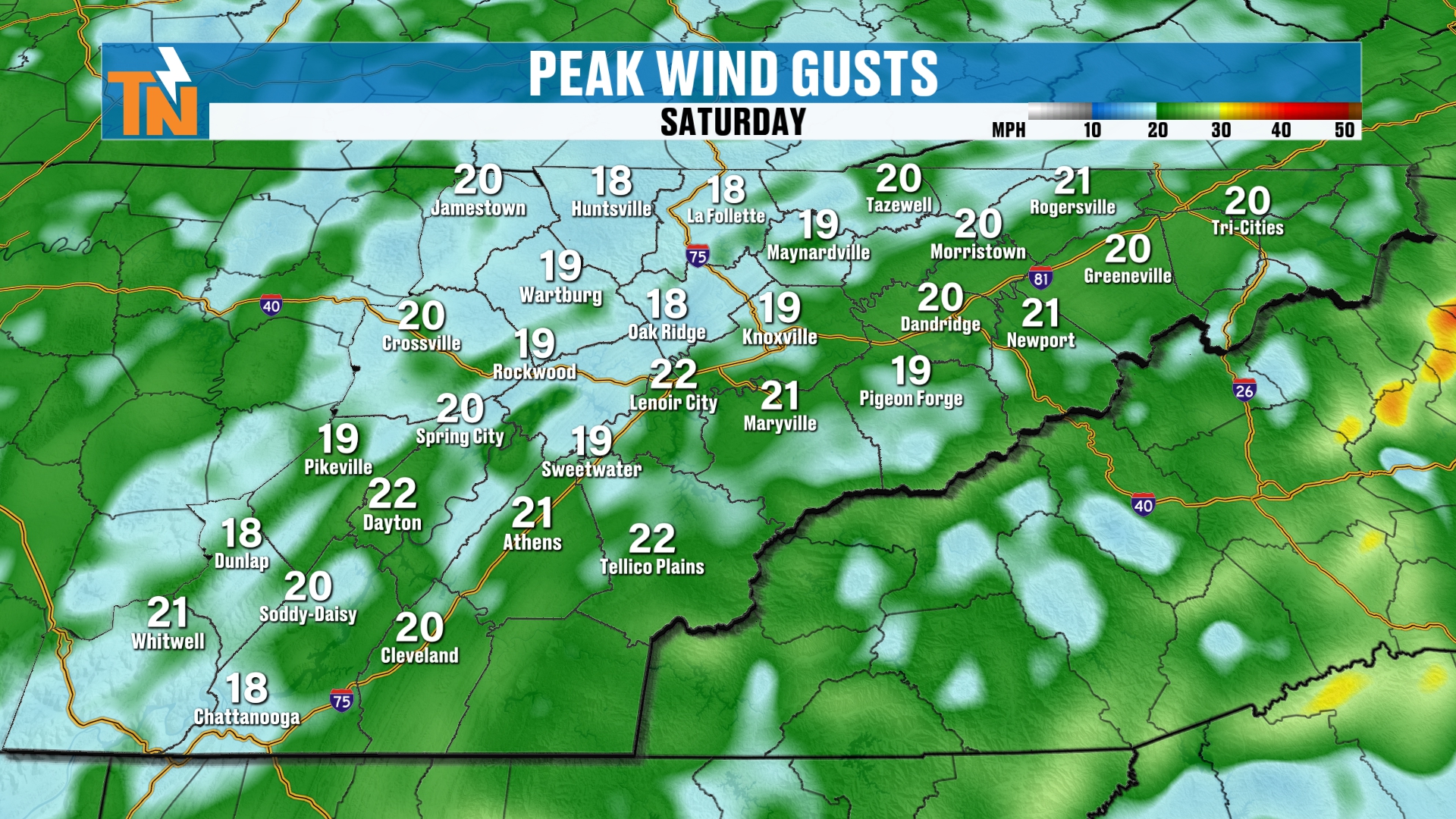
Here we go. These are the peak wind gusts throughout the day on Saturday.
Again, it’s going to be breezy and cooler. So you’re definitely going to feel that more fall feeling here this weekend.
You’ll need the sweatshirts and the jackets, especially if you’re heading out and about early in the morning or in the evening hours.
Now, that moves its way on out. We might have a batch of clouds kind of skimming across the northern valley as we get into Sunday night, as that upper-level low finally wraps up its course and moves on out of here.
High pressure builds back in for our Sunday and Monday.
A Shot of Cooler, Drier Air
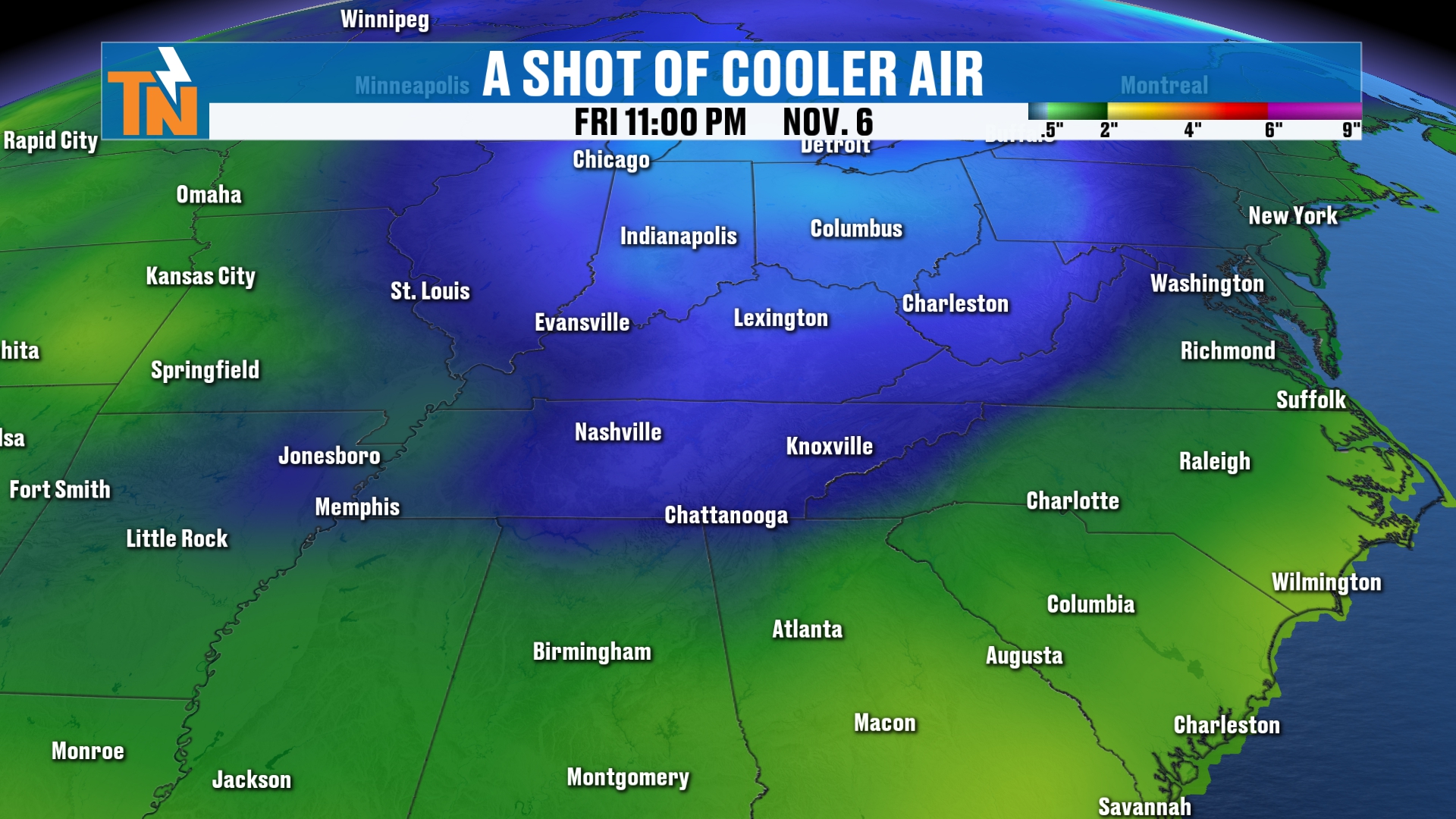
So, a shot of cooler air. We talked about this cooler air coming in, and you can see it with our 850 millibar temperatures. It comes in as we get into Saturday.
But clear skies on Sunday morning are going to allow those temperatures to come on down.
Not to mention this cooler air is originating out of Canada, of course, and that’s going to bring us even drier air.
Dry Air Means Static Electricity
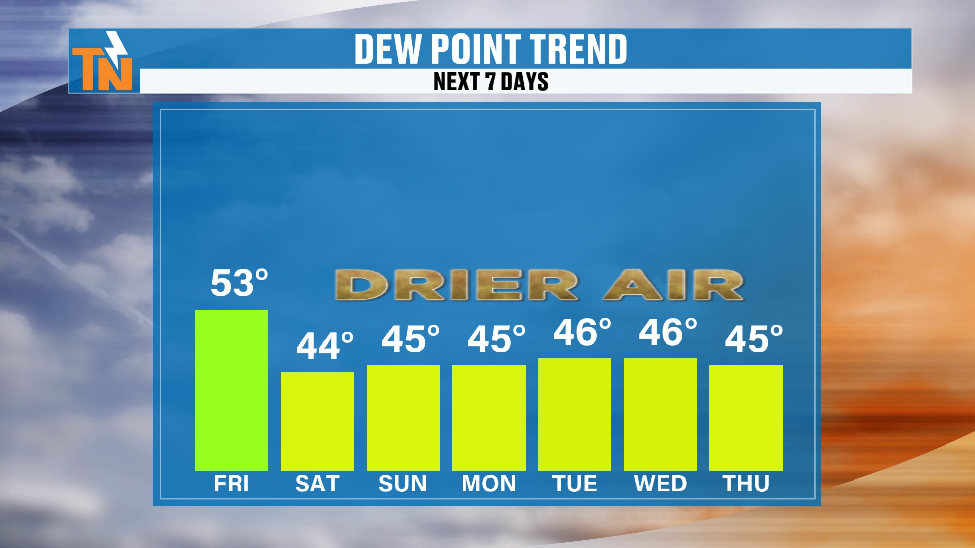
So, static electricity increases this weekend.
The drier the air is, the more static electricity there’s going to be. Now, it’s not going to be too crazy, because we really need dew points to be much lower, in the 20s or maybe even less than that.
Either way, drier air is going to be settling in. That’s going to give us the cooler temperatures.
Chilly Mornings and Areas of Frost
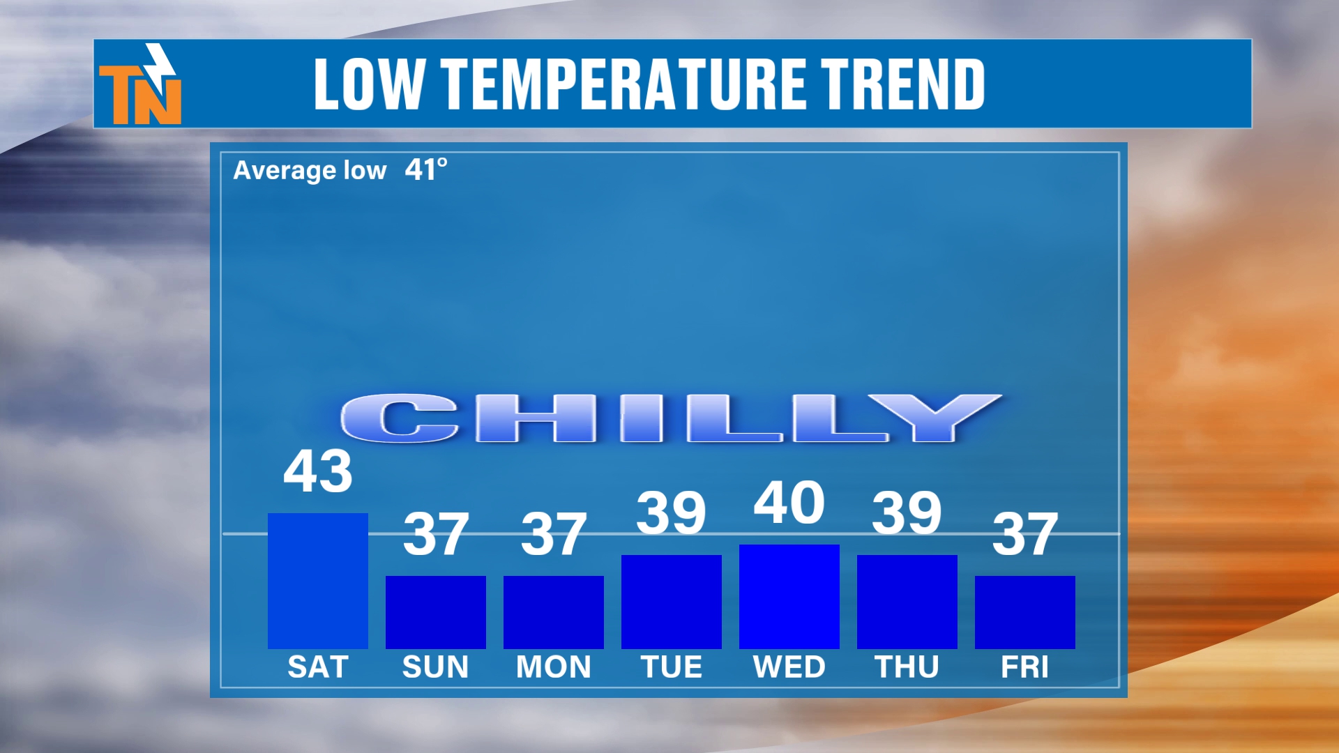
So we’re talking morning lows dipping down into the 30s and 40s, with areas of frost developing.
If you’ve got tender plants outside, keep an eye on those mornings.
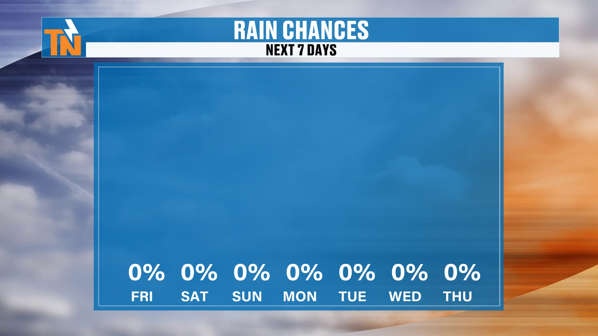
And look at the rain chances. We’re talking a 0% chance of rain over the next 7 days, and really possibly over the next 8 to 14 days.
So we’re not looking at a whole lot of rainfall on the way.
Another Shot of Cooler Air Next Week
What there is going to be is the potential of another shot of cooler and drier air as we get into the middle part of next week.
That may even bring cooler temperatures than what we’ll experience here this upcoming weekend.
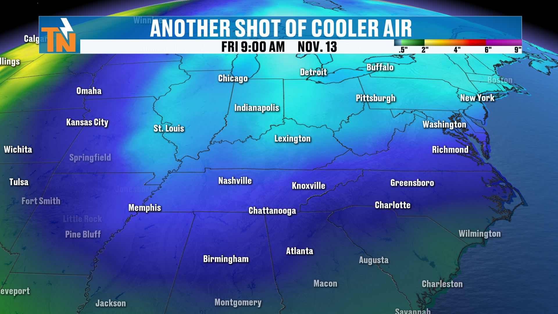
You can see the lighter shades of blue there indicating colder air. That is the possibility by, say, next Thursday and Friday.
Of course, we’re a week away, so we’ll keep watching it.
What About the Long Range?
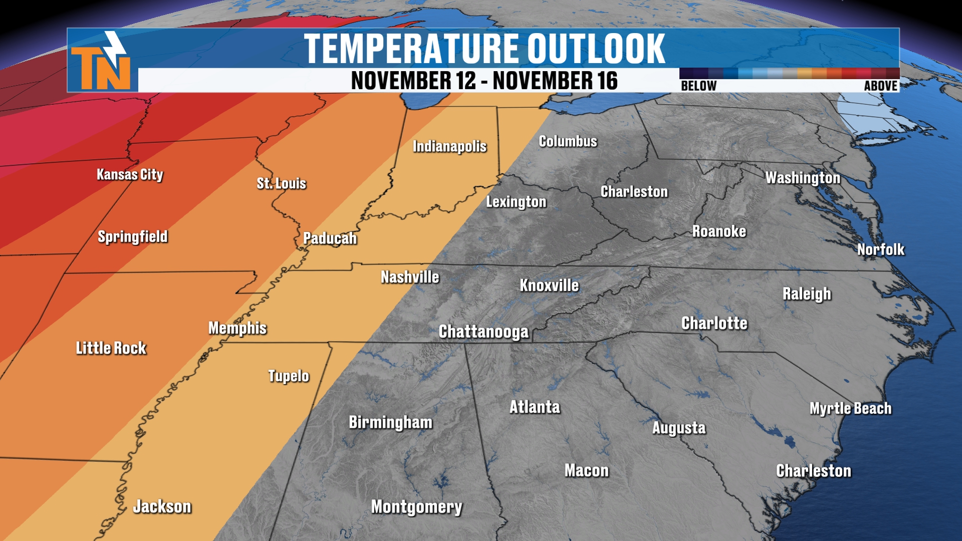
The Climate Prediction Center is saying, no, maybe not so much. Maybe average weather.
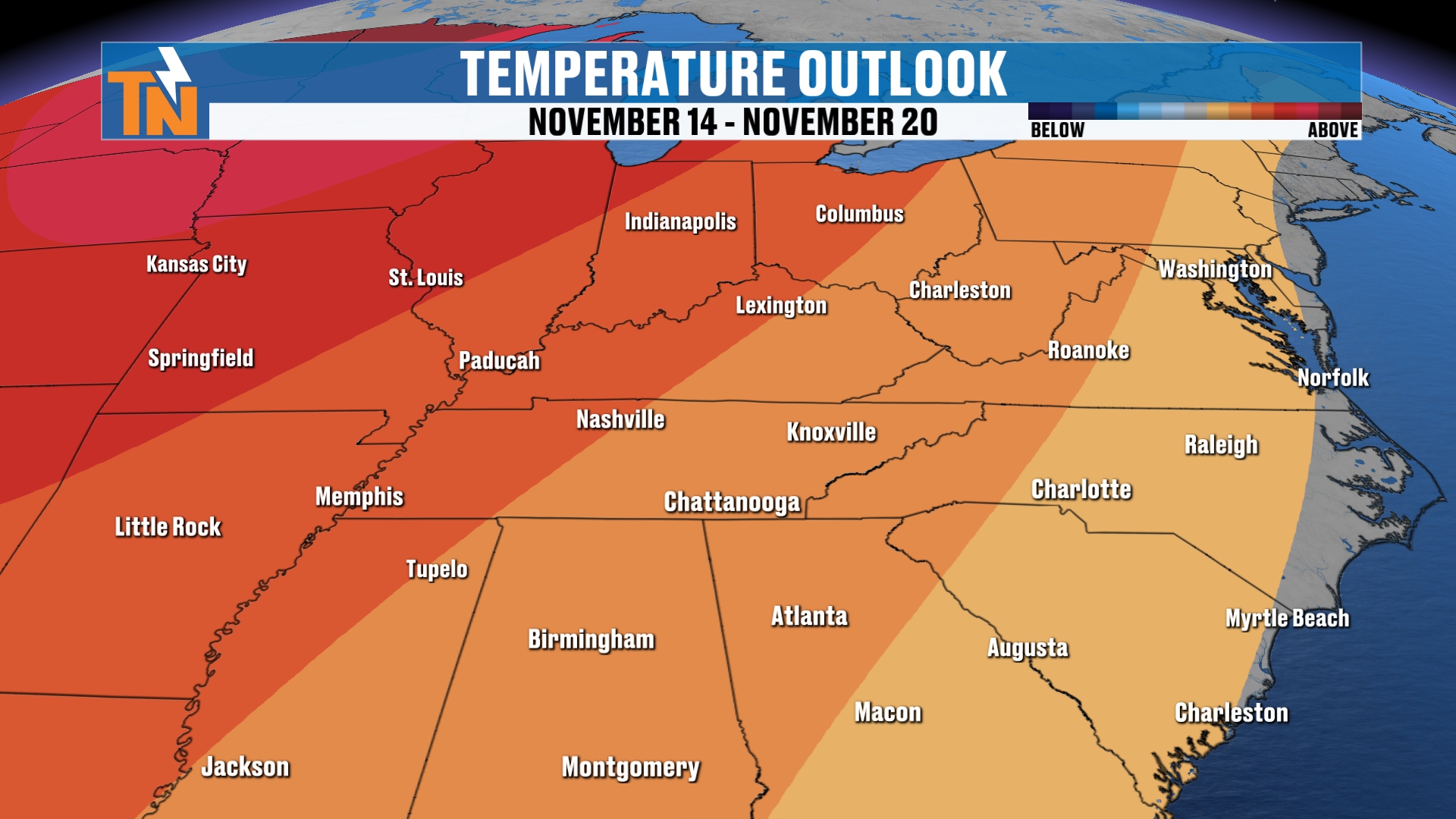
Then it warms to above-average weather as we get into your 8 to 14 day outlook. So that takes us well beyond the 7-day forecast.
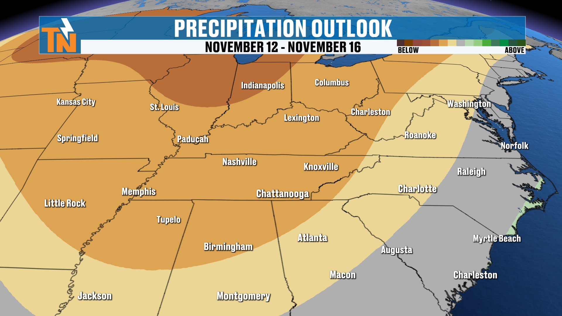
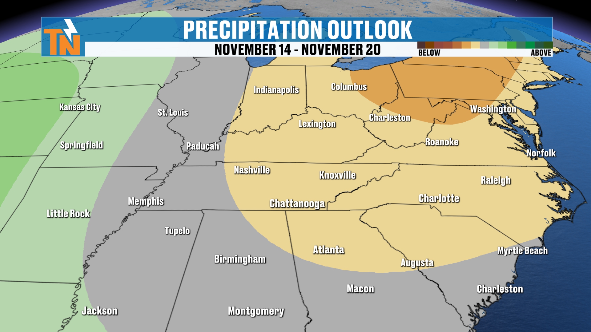
And again, not much rainfall in the picture.
Your 7-Day Forecast
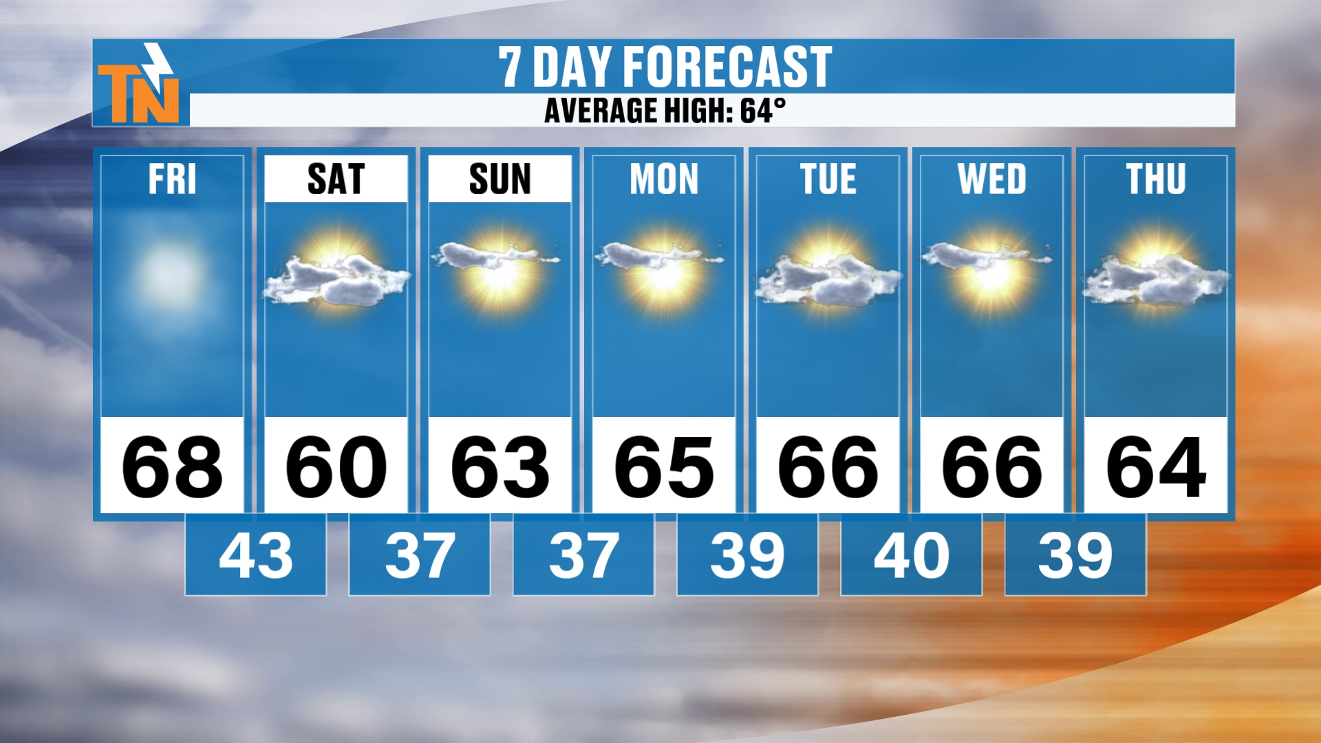
Speaking of the 7-day, here it is.
We’ll go 68 degrees today. Low 60s on Saturday and Sunday. Mid 60s on Monday, Tuesday and Wednesday. On Thursday we’re still hanging on to 64.
But Friday and Saturday of next week, we may see a drop in those temperatures into the 50s.
Bottom Line
FRIDAY: Starting off in the 40s and 50s with some fog, then plenty of sunshine. Clouds filter in around lunchtime and thicken through the afternoon. Mid 60s by lunch, upper 60s to low 70s for the kids heading home from school, and a high around 68 to 69 in Knoxville. Winds gust 15 to 20 miles per hour late afternoon into the evening as the cold front comes through. A sprinkle can’t be completely ruled out, but it’s likely dry.
FRIDAY NIGHT: High school football, with mostly cloudy skies by 7 PM. Around 60 at 6 PM, 55 by 8 PM and about 52 by 10 PM. Good luck to the Panthers at Powell!
SATURDAY: Clouds in the morning, then more sunshine through the day. Breezy and much chillier. A low in the 30s and low 40s and a high in the 50s to near 60. UT kickoff is at 6:15 with temperatures dropping into the low to mid 40s.
SUNDAY AND MONDAY: High pressure builds back in. Clear skies and drier air allow for areas of frost, with lows in the 30s and 40s. Highs in the low to mid 60s.
TUESDAY AND WEDNESDAY: Mid 60s for highs and more chilly mornings with areas of frost possible.
NEXT THURSDAY AND FRIDAY: Another shot of cooler, drier air could arrive, possibly cooler than this weekend, with highs back into the 50s by next Friday and Saturday.
RAIN: 0% for the next 7 days, and possibly the next 8 to 14 days.
LONG RANGE: The Climate Prediction Center is leaning toward average weather and then warming to above average in the 8 to 14 day outlook.
So to recap: another cold front arrives today with a batch of clouds and a little breeze, and a cooler, drier weekend follows with areas of frost and no rain in sight.
Don’t forget to LIKE, SHARE and SUBSCRIBE to this YouTube channel, and hit the bell at the top so you’re always notified when I drop a new weather update. I really do appreciate you checking in.
Let me know what you’ve got going on this weekend! If you made it this far, throw something in the comments. I’m heading to the football game tomorrow, and I’ll be taking some pictures and posting them on social media.
Make sure you download my FREE eastTNweather app from your app store. You get lightning alerts, watches and warnings, and an interactive radar that gives you past, current and future radar.
Catch up on all of my recent daily forecasts anytime.
I’m Meteorologist Mike Witcher. Have a great Friday!
eastTNweather — Weather When You Want It.