
Published: Sunday, November 8, 2026 | By Meteorologist Mike Witcher | eastTNweather
Good morning, East Tennessee, and happy Sunday! Thanks for checking in with your morning weather update on this November 8th, 2026. The big headline is the first snow chances of the season, and we have ensemble data this morning to show you the real probabilities.
After a little bit of fog this morning and some chillier temperatures, we’re going to warm nicely throughout the day today. A good, solid weather pattern is on the way for the early part of the week.
But as we get into the middle and latter part of next week, there are some changes on the way.
If you saw my evening forecast last night, we were talking about the potential for maybe our first snowflakes around the area. I still think that’s possible.
So what are the chances of us actually seeing some snowfall by the middle and latter part of next week? We’ve got all those answers coming up.
Yesterday's Almanac
All right, let’s talk numbers here for a second.
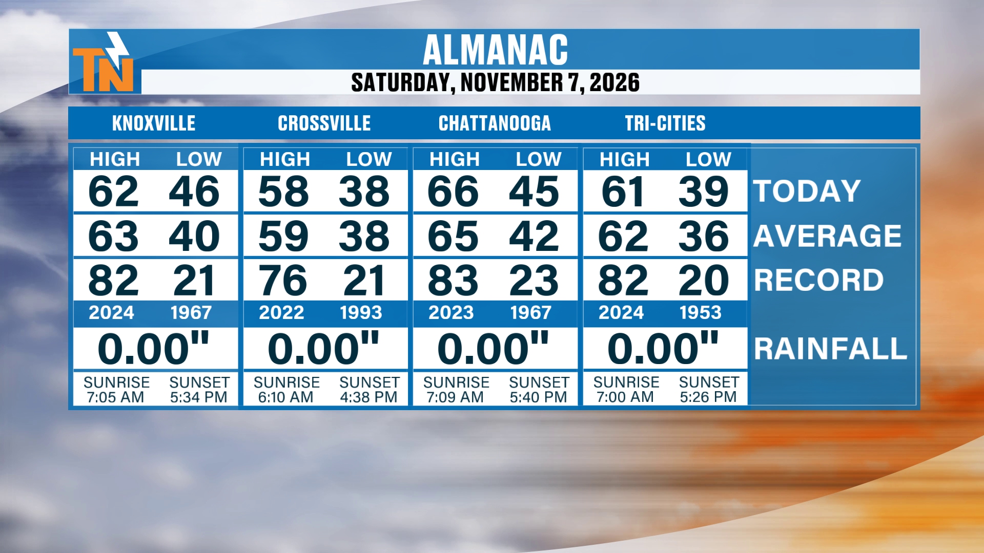
We did make it into the 50s and 60s yesterday. We made it to 62 degrees in the Knoxville area.
It turned out to be a beautiful day, and of course a nice cool evening around town if you went off to the football game.
The almanac shows Knoxville with a high of 62 and a low of 46. Crossville topped out at 58 with a low of 38. Chattanooga reached 66 with a low of 45, and the Tri-Cities had a high of 61 and a low of 39. No measurable rainfall at any of the four.
Fog in the Smokies and a Trough on the Way Out
Speaking of around town, let’s take you down to Townsend and show you what it looks like. They’ve had Grits and Grains going on down there this weekend. It’s a nice little event on the peaceful side of the Smokies.
A little bit of fog, but that fog is already starting to burn off, and we’re looking at more sunshine returning throughout the day today.
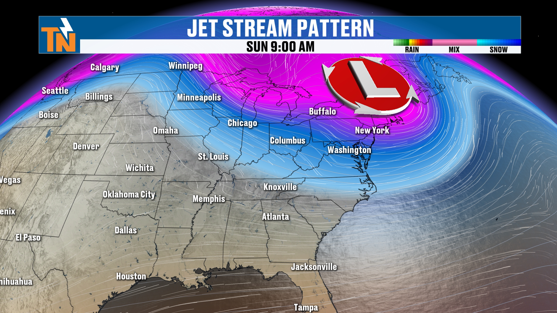
All right, but even colder weather is on the way, as the title says. We are talking about a deeper trough than what we’re experiencing out there this morning.
So there’s our trough, our low pressure system, that’s starting to lift its way on out of here. High pressure is starting to build its way back in.
Frost This Morning, Colder Than Yesterday
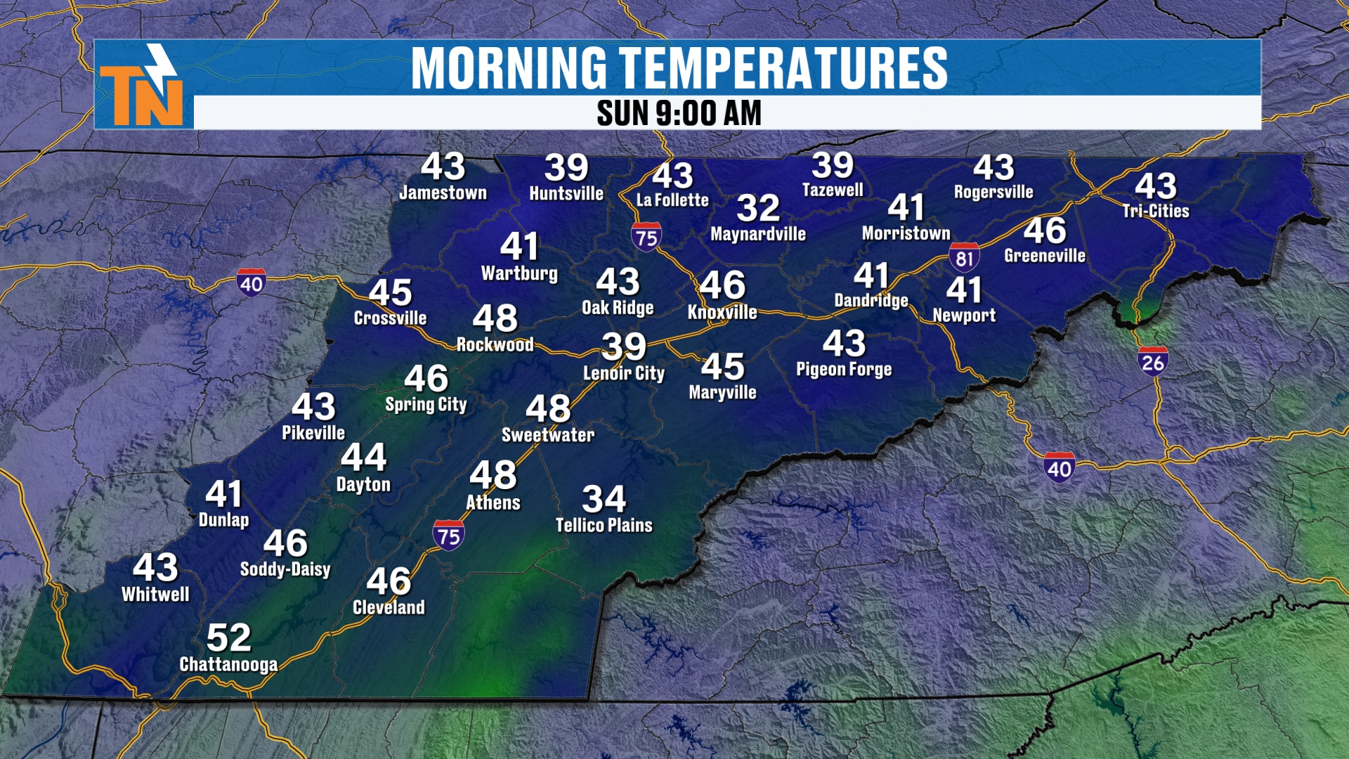
We started the morning off with temperatures in the 30s and 40s. There was a little bit of frost around the area.
Let me know in the comments if you happen to have any frost in your area this morning.
I think we have a chance for seeing some more widespread frost tomorrow. But the potential for a hard freeze comes our direction as we get into next week. I’m going to talk more about that as well.
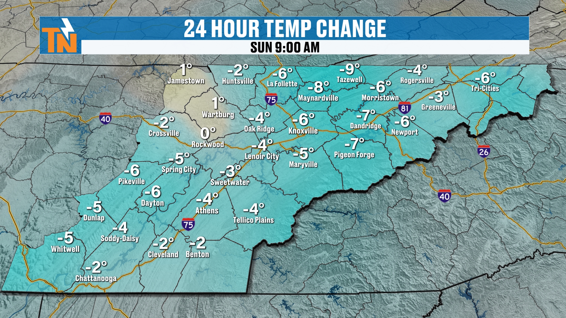
As for the temperature change, we’re trending colder. We’re about five, nearly 10 degrees colder than what we were yesterday.
Today: Warming Into the 60s
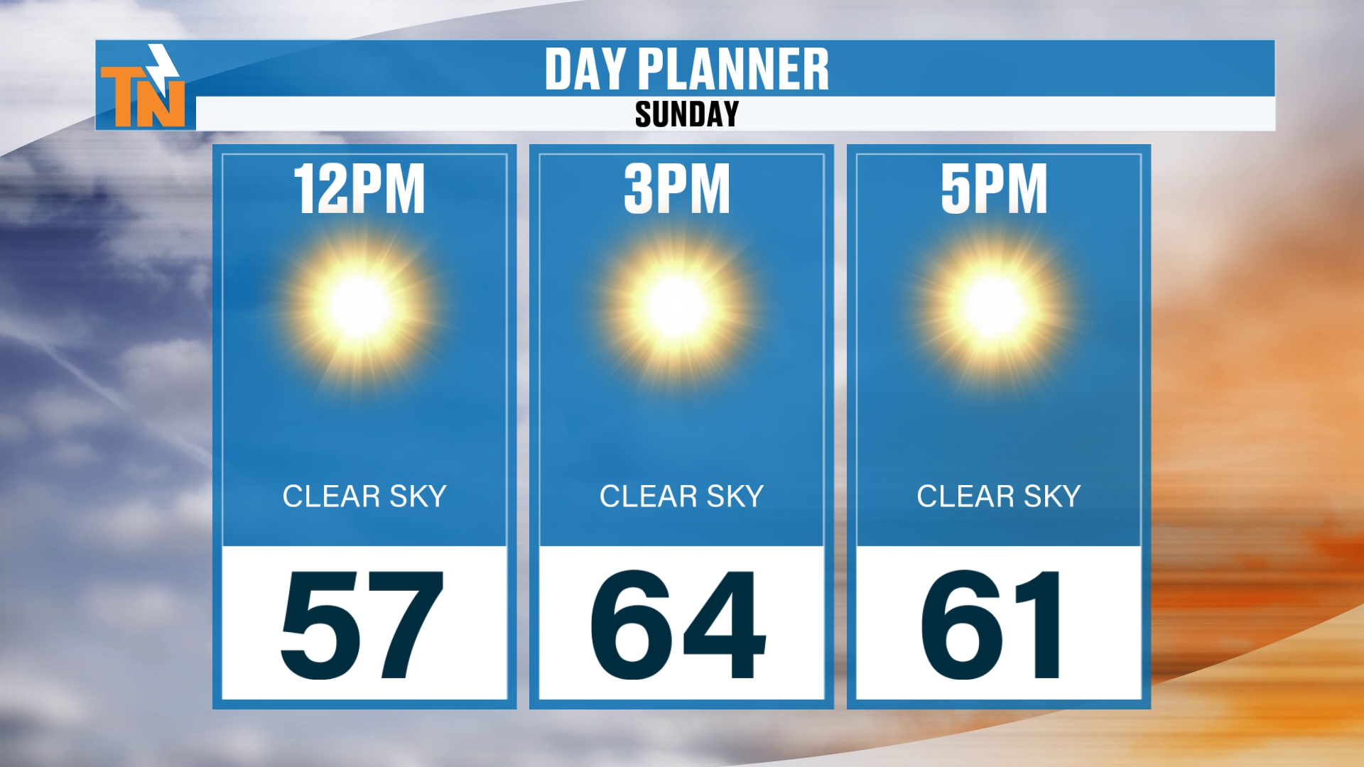
Here’s your forecast ahead of us today. We’re at 57 by lunchtime. 64 is going to be the goal today as we get into the 3:00 hour, and that’s generally the rule of thumb.
So it’s a solid, average day ahead of us. Average highs for this time of the year are in the low to mid 60s.
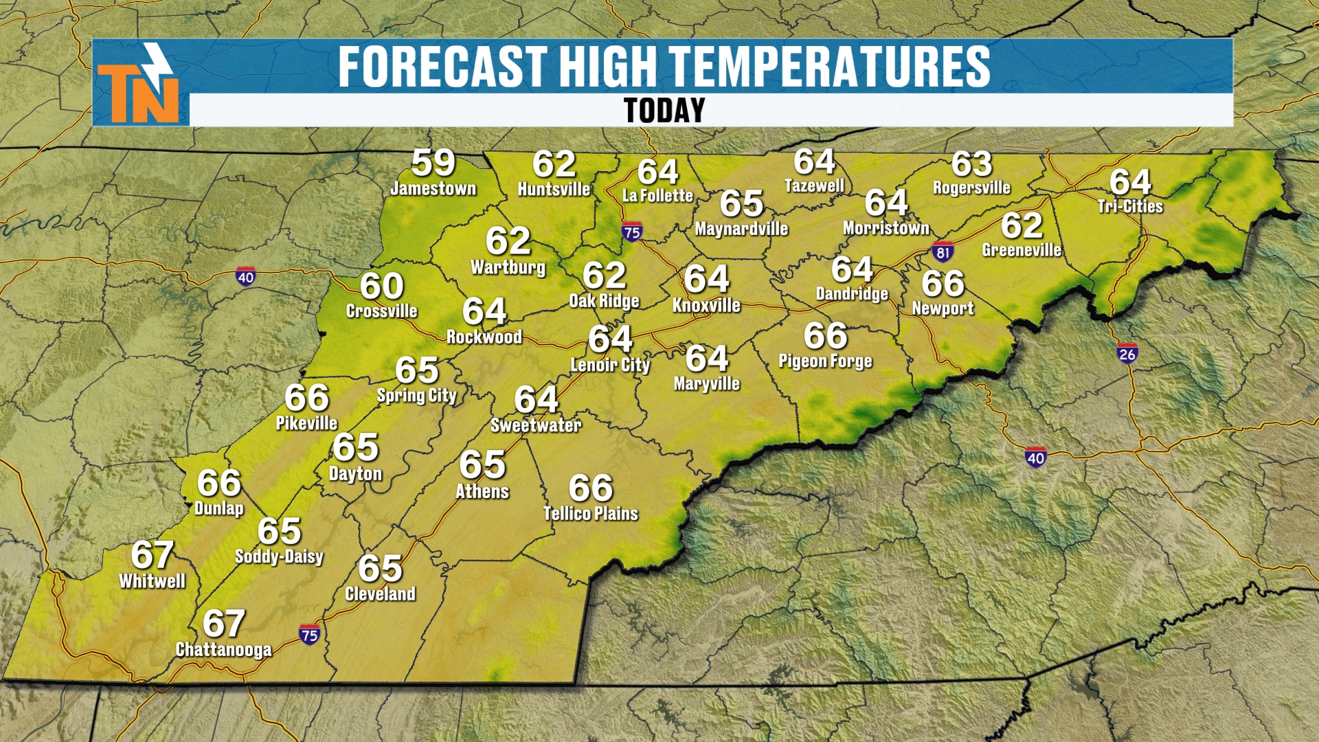
The high temperature map shows the same story. Most of us land in the low to mid 60s this afternoon.
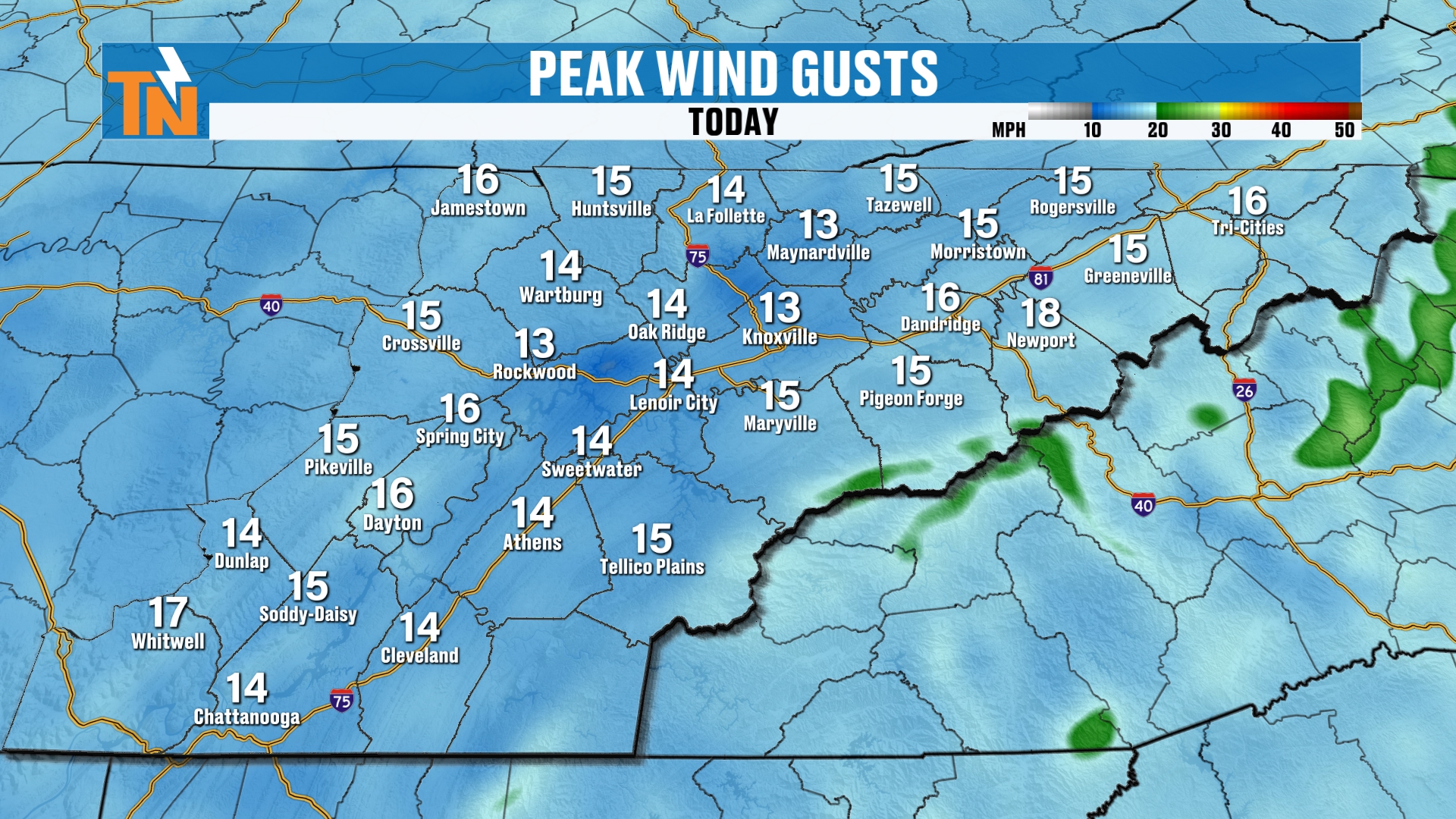
Wind is not necessarily an issue. But a little bit of an afternoon breeze can’t be ruled out.
It’s not as windy as it was yesterday, because of course the cold front came through yesterday.
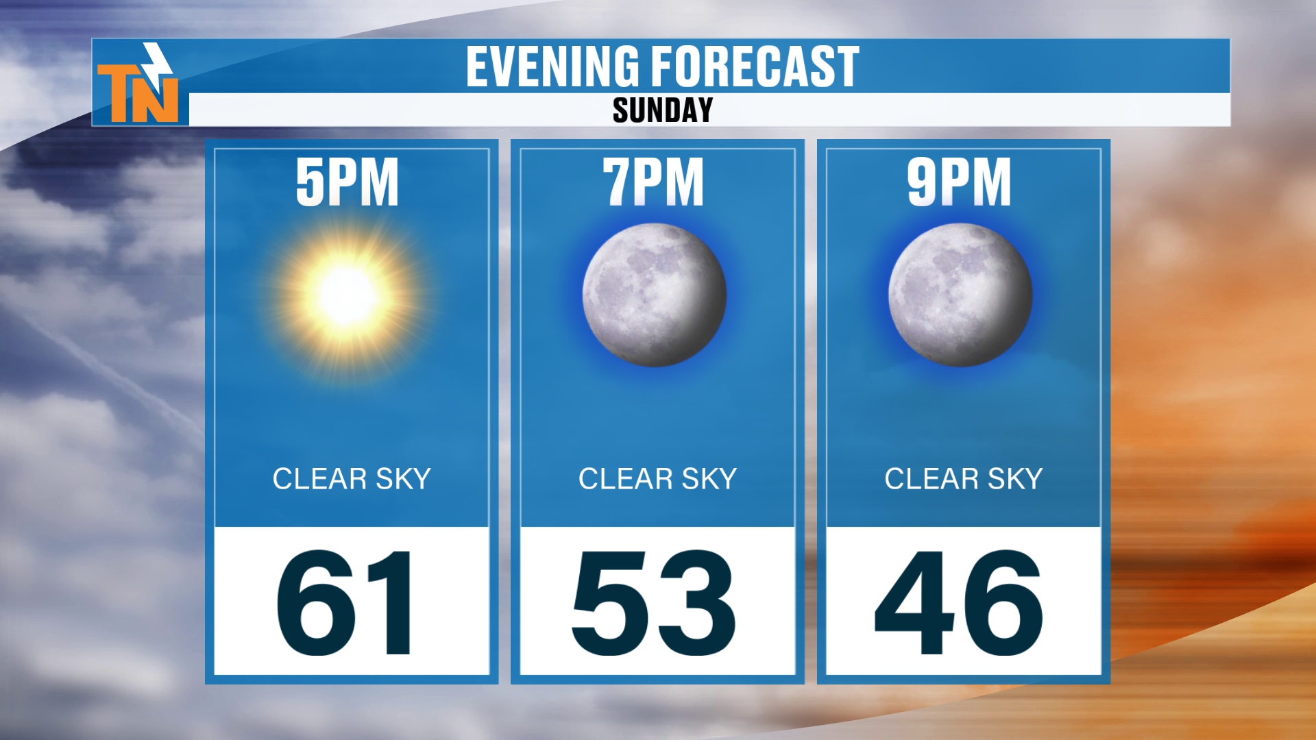
If you have any evening plans here tonight, we’re at 61 by 5, 53 by 7, and we’re going to be down to about 46 by 9.
Monday Morning Frost and a Look at the Next Seven Lows
As we get into our Monday morning, we still have the chance for some frost around the area.
Where you see any blue, that’s where you have a better chance for some frost. Where you see the brighter shades of blue, that’s where you have a better chance of seeing maybe a little bit more of a hard freeze.
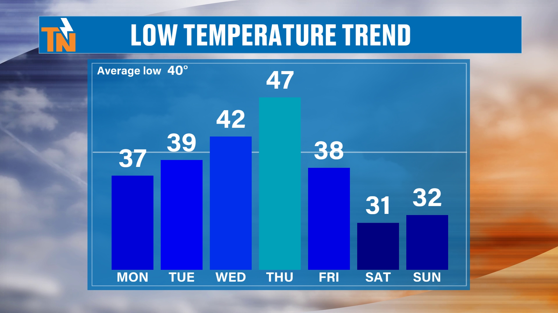
Here’s the low temperature trend over the next seven days. We warm things up. We’re back to 47 degrees for a morning low on Thursday.
Can you pick out when the cold front is going to come on through? Right. Thursday into Friday, that colder air is going to come on in.
And that’s going to leave us with some chilly weather this weekend.
Saturday Morning: Our Next Big Cold Morning
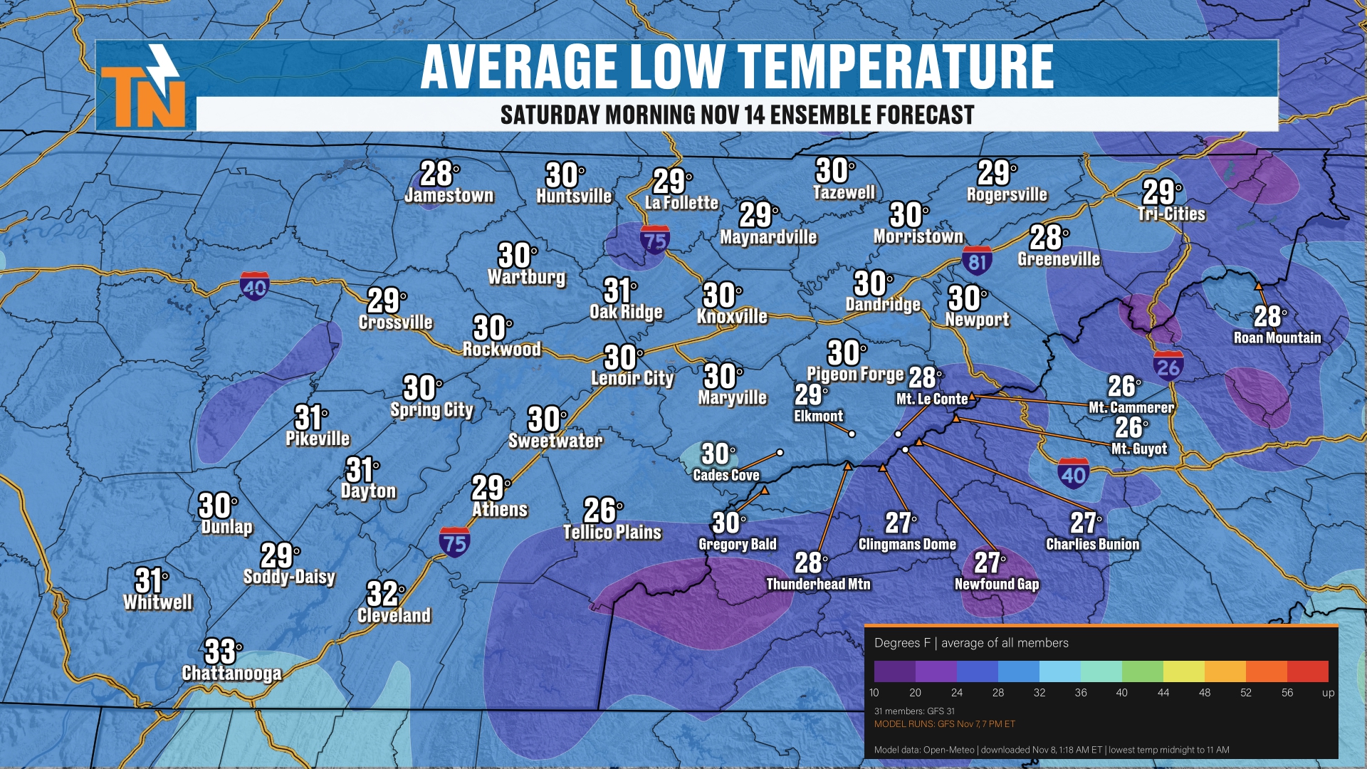
So let’s talk about low temperatures. We’re talking Saturday morning. That’s going to be our next big cold morning.
A week from yesterday, anyways. This is November 14th, and this is your ensemble forecast.
The average lows per all the ensembles is about 30 degrees. So 20s and low 30s next Saturday.
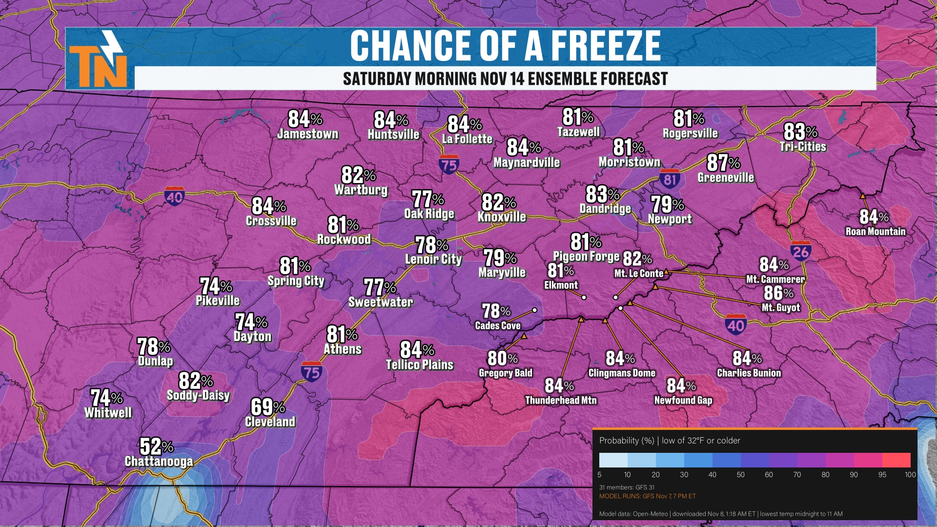
That gives us about a 70 to 80% chance of a freeze Saturday morning.
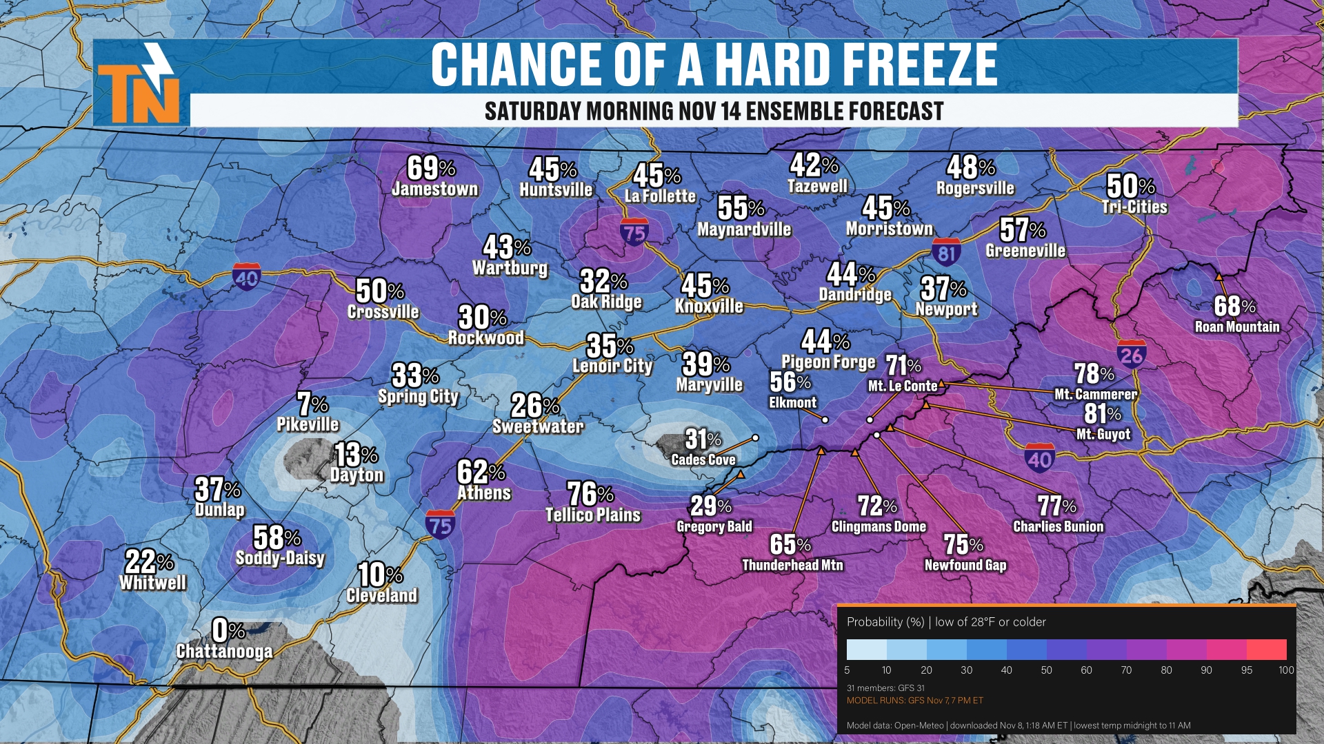
But what’s the chance for a hard freeze? Well, in the valley locations, probably about a 20 to 40% chance for a hard freeze.
Along the Cumberland Plateau, it’s upwards of about a 50 to 60% chance for a hard freeze. And of course, a hard freeze is looking likely in the Smoky Mountains.
Again, that’s all associated with this next deep trough that’s going to be swinging its way into the area as it starts to dig in on Thursday. That’s November 12th. It takes us into Friday and Saturday.
You can see how this deep trough is animated. Of course, things are going to change a little bit here over the next 5 to 7 days. But this has been the forecast here for the last couple of days.
The Setup: Rain First, Then Wraparound Moisture
Let me walk you through our radar depiction, our Futurecast. It is likely to bring us some rain showers on the leading edge of the cold front.
Then on the back side, we’ll probably get some wraparound moisture. And then here comes the colder air.
When we get this kind of a storm, on the backside we’ll get wraparound moisture in the Smoky Mountains.
So our best potential for seeing any sort of frozen precipitation, at this point of the game, on the back side of the storm is going to be across the higher terrain and the northwest-facing slopes.
First Snow Chances: Your Snowfall Forecast
Let’s go ahead and talk about your snowfall forecast.
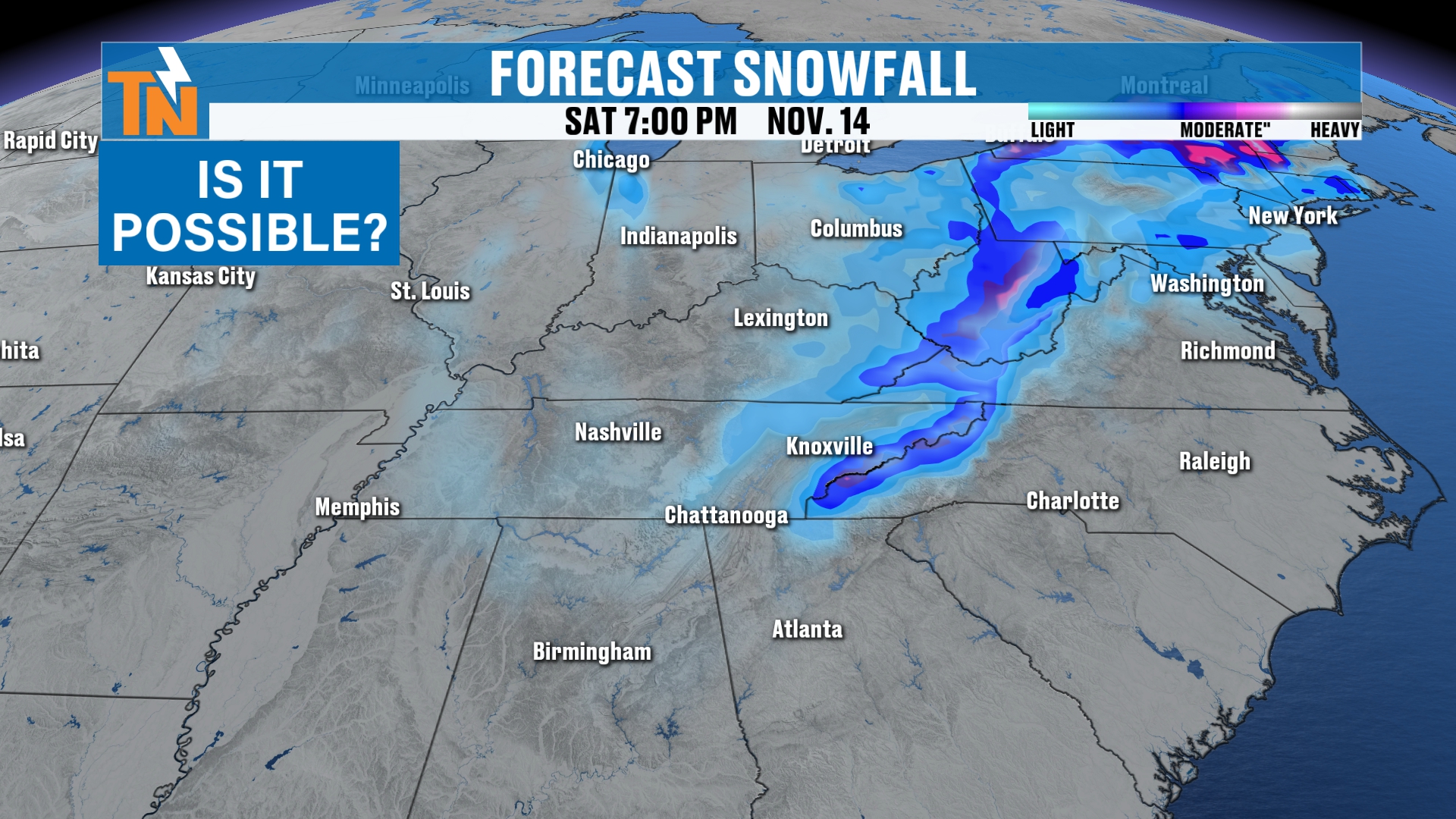
So when you look at your snowfall, is it possible around the region? Yeah, it’s possible.
It’s not looking as intense as it was yesterday. I think this model guidance has a much better handle on what we potentially could see.
Right along the spine of the Appalachians, from West Virginia down to the Tennessee and North Carolina border, that’s where I think we definitely have the greatest potential for seeing some light snow showers.
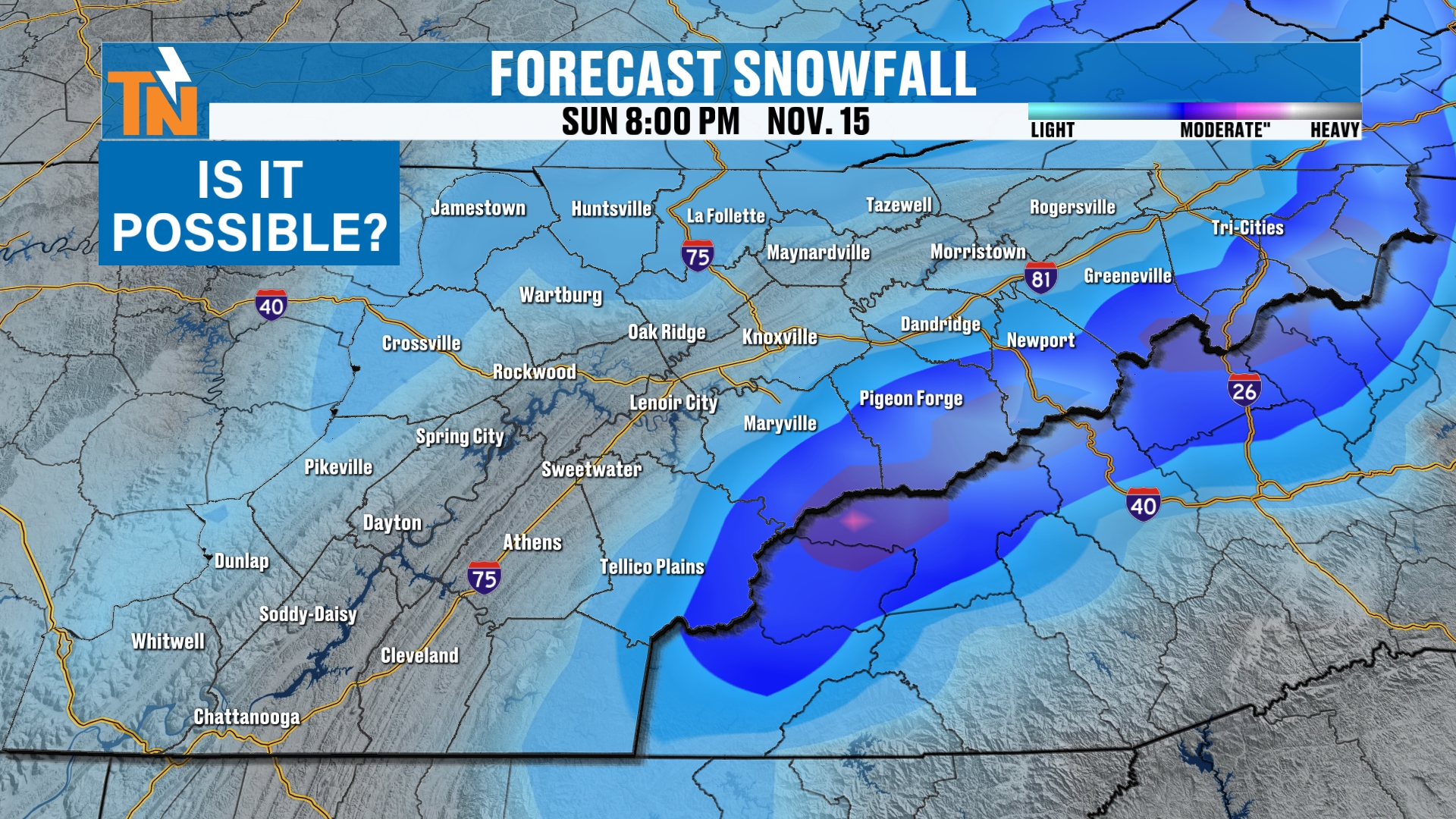
Now, notice the classic horseshoe shape around East Tennessee. We’ve got higher terrain across the Plateau and the Smokies.
The Horseshoe Effect
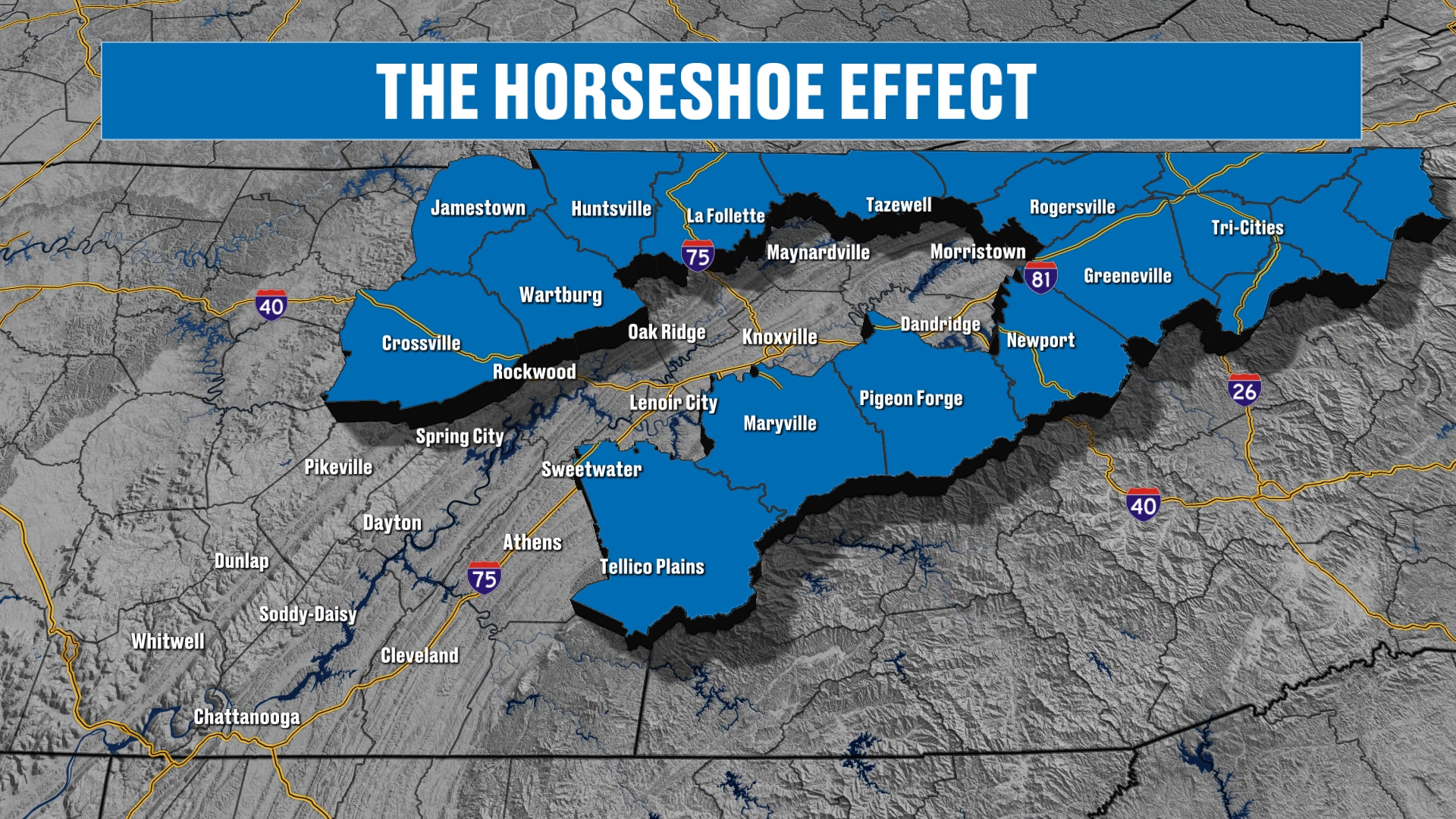
Let me highlight that. You’re going to hear me talk about it a lot here this wintertime when we’re talking snowfall potential, because the horseshoe effect is what we call that here in East Tennessee.
If you’re new to the platform, this shows you the higher terrain. The Plateau runs up to about 1,300 feet above sea level. The mountains go upwards of over 6,000 feet. And the lower elevations in the valley are up to about 1,000 feet.
Because of the higher terrain, you have a better chance for seeing snowfall in the wintertime, on wraparound moisture and in any snowfall event, because you’re higher in elevation.
Snow Probabilities: Who Has the Best Chance?
So let’s talk about probabilities now when it comes to snowfall.
When you’re looking at probabilities for snow, we’re looking at 7:00 in the morning on Thursday. We’re not necessarily looking at any snowfall Thursday morning. But watch how the probabilities start to increase throughout the day on Thursday.
Now, we’ve got the cold front off to our east. The wraparound moisture is going to start to come on in. The probabilities for seeing any sort of snow, and this is just any sort of snow, are going to start to ramp up across the higher terrain, because of course the mountains go up higher in elevation.
But notice as we get into our Friday evening, there’s a little bit of a chance for some light snow showers across the Plateau. Really, though, when you’re looking at the probabilities for snowfall at all, the mountains of East Tennessee and North Carolina have the best probabilities.
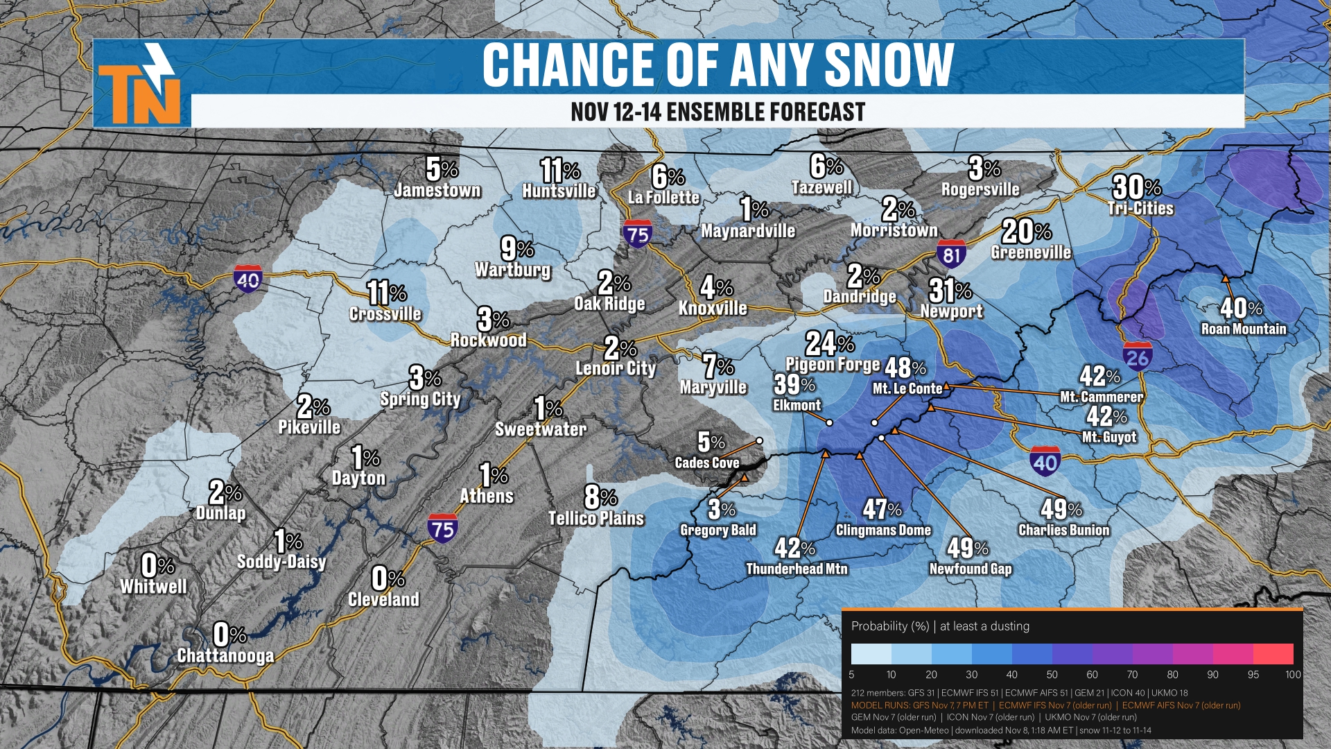
Here is the chance of any snow, November 12th through the 14th. Again, we’re sticking with your ensemble forecast.
For any chance of snow, we’re going about a 10% chance at best across the Plateau.
The best chance is going to be across the Smoky Mountains. We’re running about a 40 to 50% chance across the higher terrain, from Mount LeConte, Mount Cammerer, Charlies Bunion, Clingmans Dome and Cades Cove.
So again, that’s about a 5 to 40% chance of snow even happening at all.
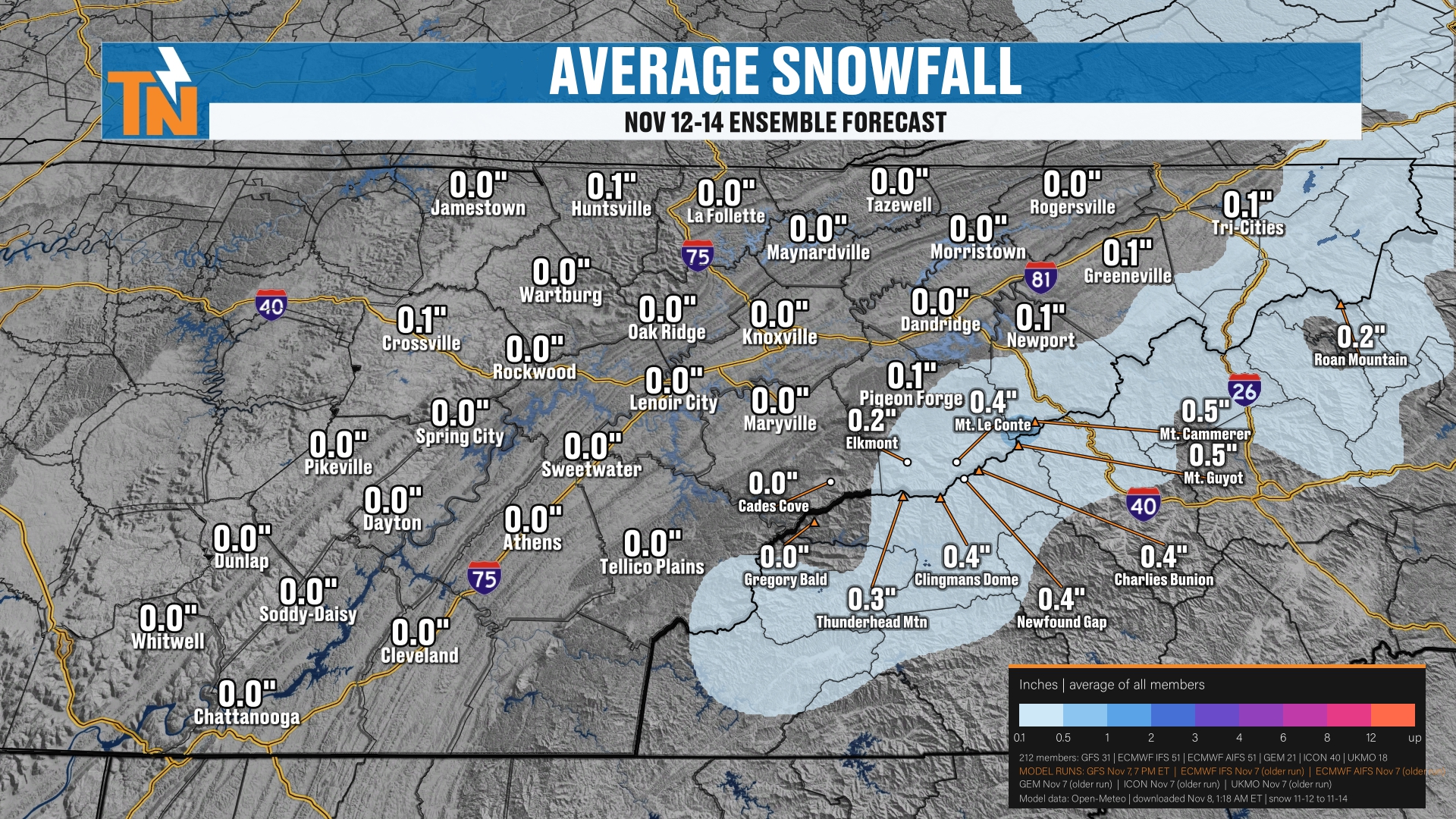
The average snowfall, if we were to get it, based on the ensembles, is about half an inch across the highest peaks. So this is not looking like a huge snow maker by any stretch of the imagination.
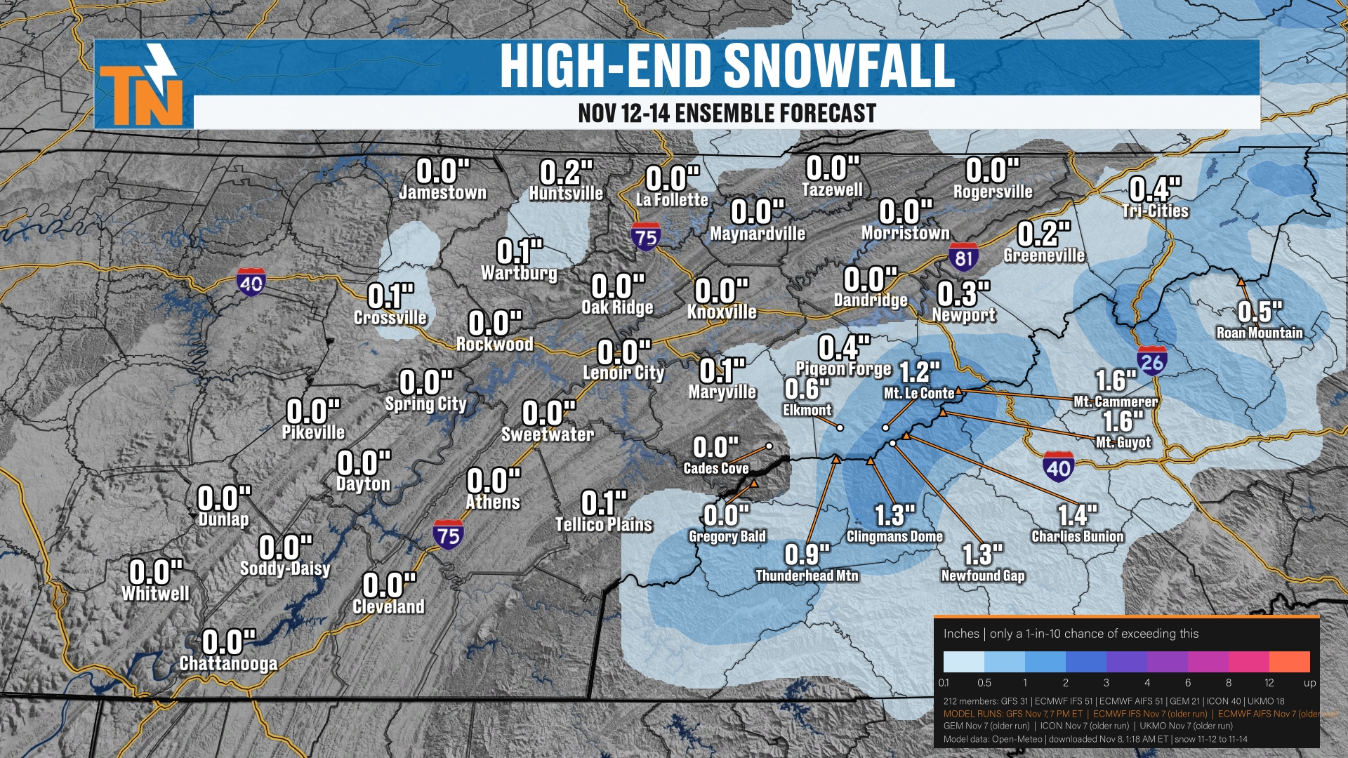
But the high-end snowfall forecast could be upwards of about an inch to 2 inches.
Precipitation Chances: How Much Moisture Do We Get?
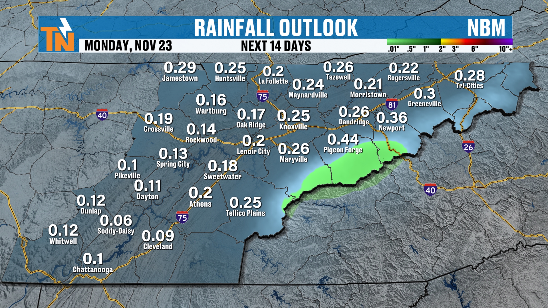
Generally speaking, this precipitation outlook highlights how much precipitation we can precipitate out of the atmosphere. Again, this kind of tells the story that the higher elevations have the best chance for any sort of precipitation. And some of that might be in the form of snow.
This takes us over the next two weeks, and across the higher elevations is going to be our best chance.
Welcome to these kinds of storm systems. You’re going to see how snowfall forecasts get blasted out. You’ve got to watch what you like and share. Come to a trusted source. I’ll post snowfall forecasts, but you’ve got to read the text as well.
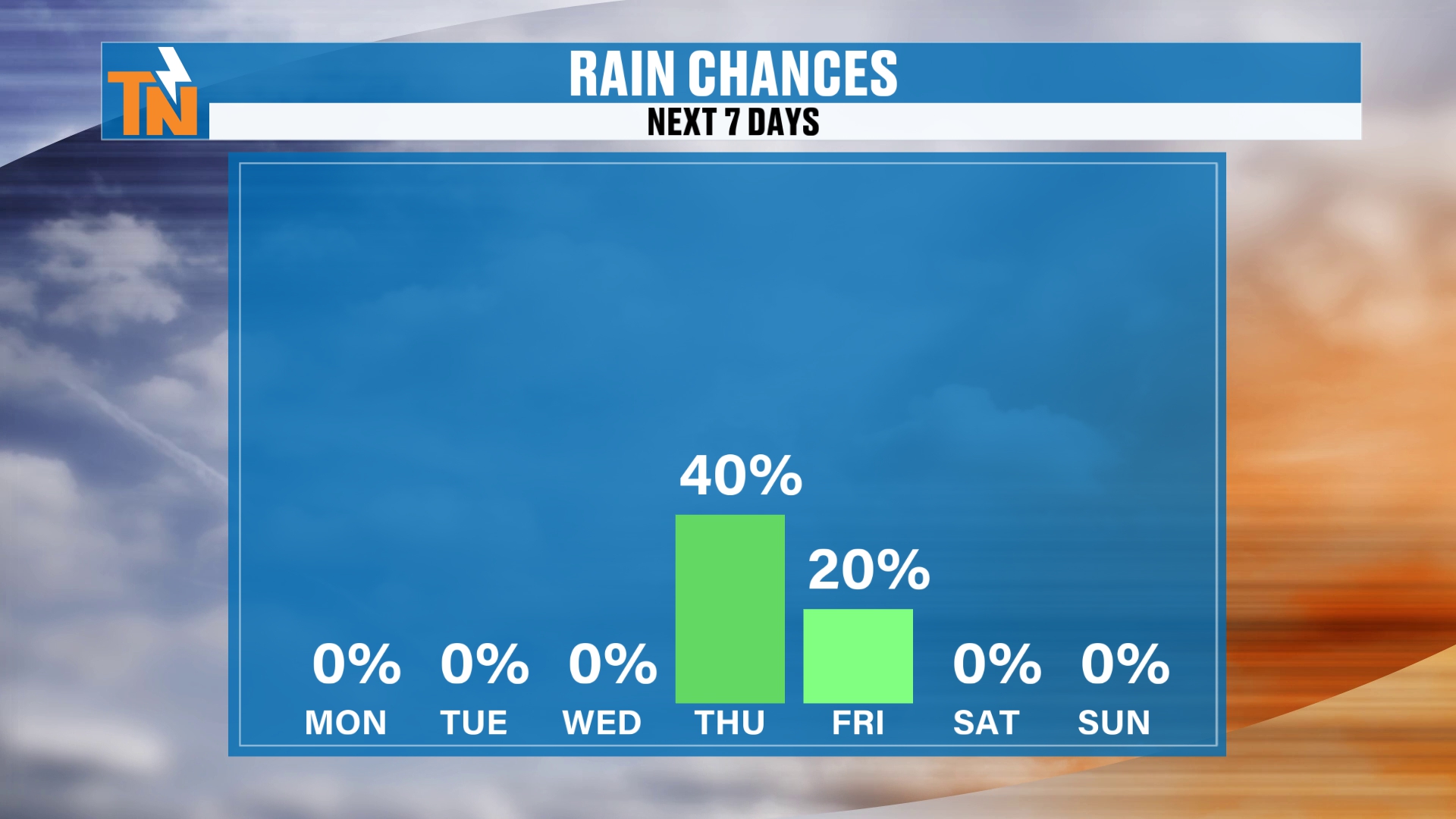
So we’ll go with a 40% chance of some precipitation on Thursday. Some of that is going to be in the form of frozen precipitation anyways. Then we’ll knock that down to about a 20% on Friday. And then the colder weather sets in Saturday into Sunday.
Beyond the Seven Days: Climate Prediction Center Outlooks
Above and beyond the 7-day forecast, 6 to 10 and 8 to 14 days out, we may start to trend on the drier side.
This is going to be our next chance of any sort of precipitation, coming through Thursday into Friday. We’ll have a little bit of light rain and some light mountain snow showers, as it looks.
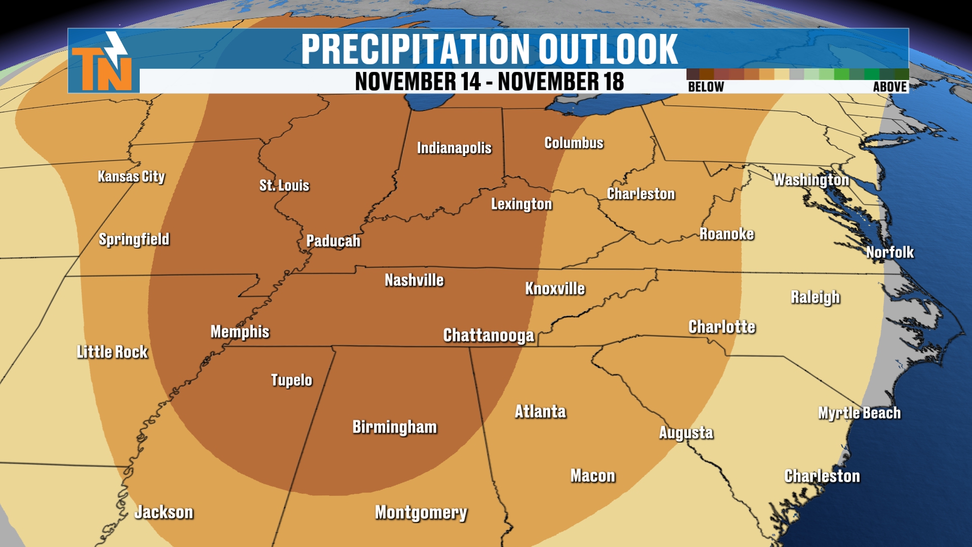
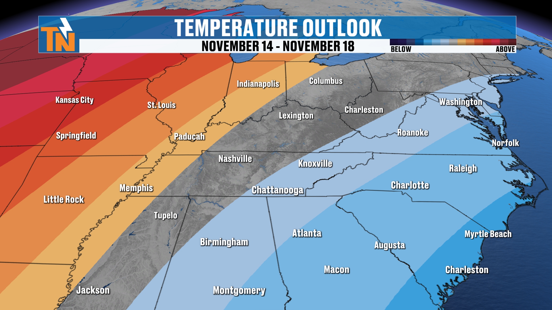
Temperatures before the front comes on through are going to warm into the mid to upper 60s. And then back behind it, we’re going to fall back into the 50s.
So again, high temperatures could be trending much colder than average. And the Climate Prediction Center is finally picking up on that colder weather that’s going to settle on in as we get into next weekend.
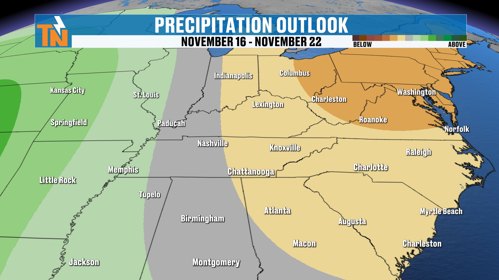
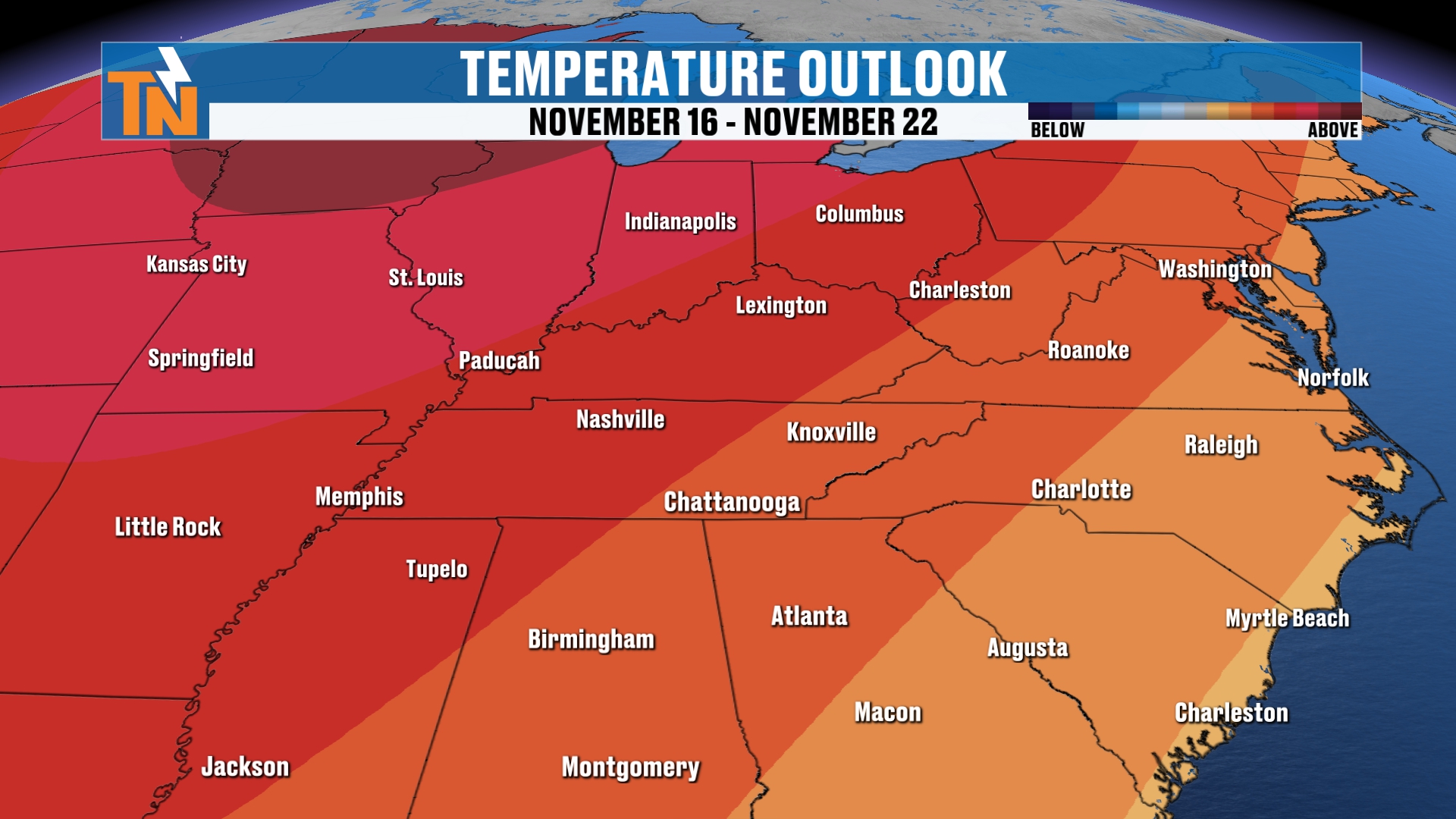
But above and beyond the 7-day forecast, you get into your 8 to 14 day outlook. And the Climate Prediction Center is also bringing back warmer-than-average temperatures.
Your 7-Day Forecast
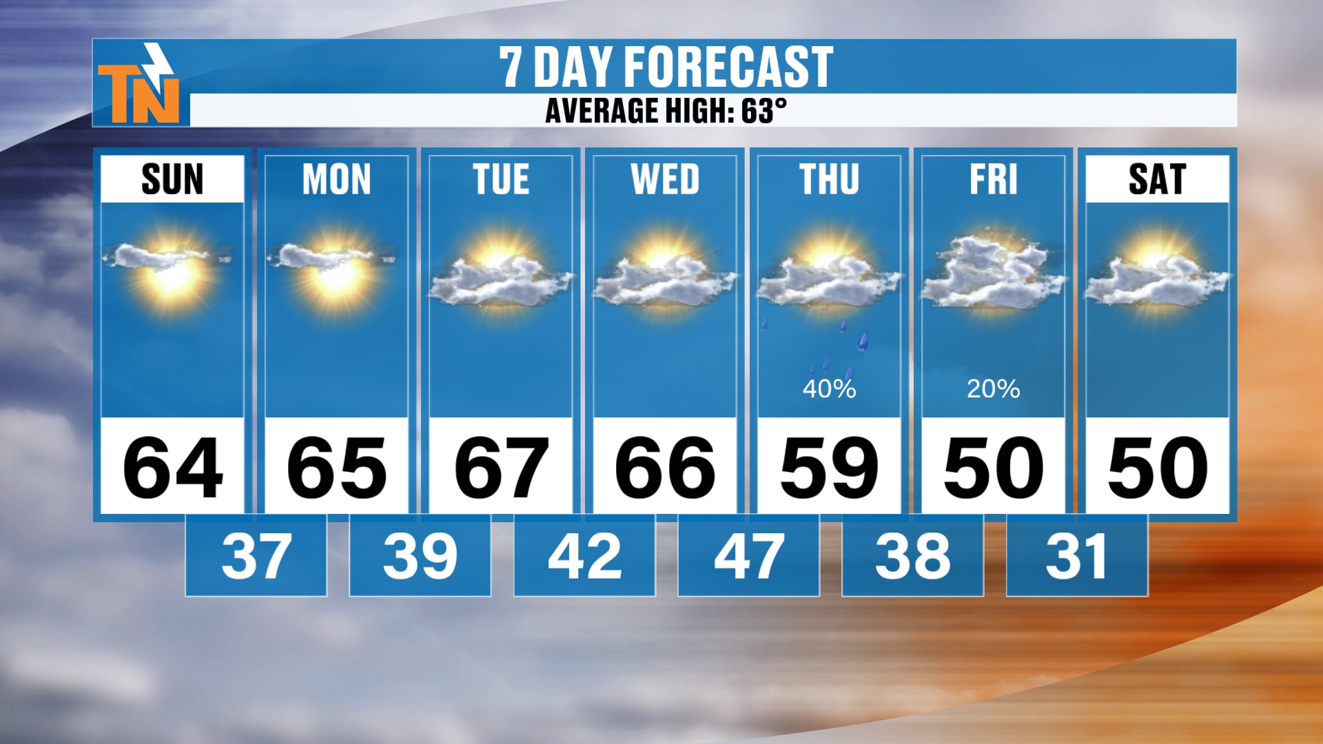
Here’s your 7-day forecast. It’s chilly this morning, and it’s going to be nice and average for the most part this week.
Next Thursday and Friday, a cold front comes on through. It could potentially bring us a little bit of light rain around the area. We’re not looking at a lot of rainfall.
It could also bring us some light snow showers. But again, we’re not expecting a whole lot of snowfall. Most of the snow is going to be falling across the higher terrain. But I can’t rule out maybe a few flakes across the Cumberland Plateau.
We’ll see how this all plays out.
And we’re looking at a good potential for a hard freeze as we get into next Saturday and Sunday morning.
Bottom Line: Your Day-by-Day
SUNDAY (TODAY): Fog burning off, then sunshine. 57 by lunchtime, 64 by 3 PM, 61 by 5, 53 by 7 and 46 by 9. Colder than yesterday by about 5 to nearly 10 degrees, and not as windy.
MONDAY: Another chance for frost, with lows in the upper 30s. Highs in the mid 60s.
TUESDAY AND WEDNESDAY: A solid, average stretch. Highs in the mid to upper 60s, with lows in the upper 30s and low 40s.
THURSDAY: A cold front brings about a 40% chance for some precipitation. Light rain, with some of it possibly frozen across the higher terrain. A high near 59 and a morning low near 47.
FRIDAY: About a 20% chance of leftover wraparound moisture. A little chance for light snow showers on the Plateau, with the best chance in the Smokies. Highs near 50.
SATURDAY: Our next big cold morning, with lows near 30. About a 70 to 80% chance of a freeze, and a hard freeze looking likely in the Smokies.
SUNDAY: Another cold morning with a good potential for a hard freeze. Colder than average.
For more daily updates, check out our Daily Forecast page.
Make sure you check in with the free East Tennessee Weather app. It’s a great tool for your cell phones, tablets and smart TVs. You can find us on Roku TV and Amazon Fire as well as here on YouTube, where you can launch the 24-hour weather channel on the big screen at home.
Lots going on here, and of course, I’m going to continue to fine-tune. So make sure you check back in each and every day as we get into next week.
Don’t forget to LIKE, SHARE and SUBSCRIBE to the YouTube channel and hit the bell. Help me continue to grow the fastest growing digital weather platform here in East Tennessee. We’re weather all the time, my friends.
I’m Meteorologist Mike Witcher. Have a great Sunday!
eastTNweather — Weather When You Want It.