
Published: Saturday, November 21, 2026 | By Meteorologist Mike Witcher | eastTNweather
Good morning, East Tennessee, and happy Saturday! Thank you for checking in with your morning weather update on this November 21st, 2026.
It’s going to be another beautiful day, but the big question for Thanksgiving week is this: Wednesday or Thanksgiving Day? The forecast models can’t agree yet on which day gets the most rain, and we’re going to walk you through exactly what each of them is showing.
We’re going to have less sunshine today thanks to some mid to high level clouds streaming through the area, and that’s associated with a coastal low. Does that bring us a chance for rain late tonight and early tomorrow morning? Potentially, yes. I’ll walk you through that Futurecast model.
Then there’s a cold front coming through tomorrow night. Does that produce any rain? Maybe. And as we get into Thanksgiving travel week, Wednesday into Thursday looks to be the rainy days, with some discrepancies in the models. One is earlier on Wednesday, one is later on Thursday. We’ll also talk about what’s in store for the Thanksgiving weekend and how cold it’s going to get.
Let’s get to work, shall we?
Yesterday's Almanac: Another Warm Day
So let’s start things off with the Almanac from yesterday. We did have another warm day. We topped out at 70 degrees in Knoxville. I was forecasting 68 yesterday, so it was definitely another above average day.
The Big Picture: High Pressure and a Coastal Low
Let’s talk about what’s going on in the big picture. We have high pressure anchored across the Southeast, a nice ridge of high pressure dominating, and that’s keeping us on the warmer side. This is our jet stream pattern, with low pressures and troughs out across the intermountain West and the Pacific Northwest.
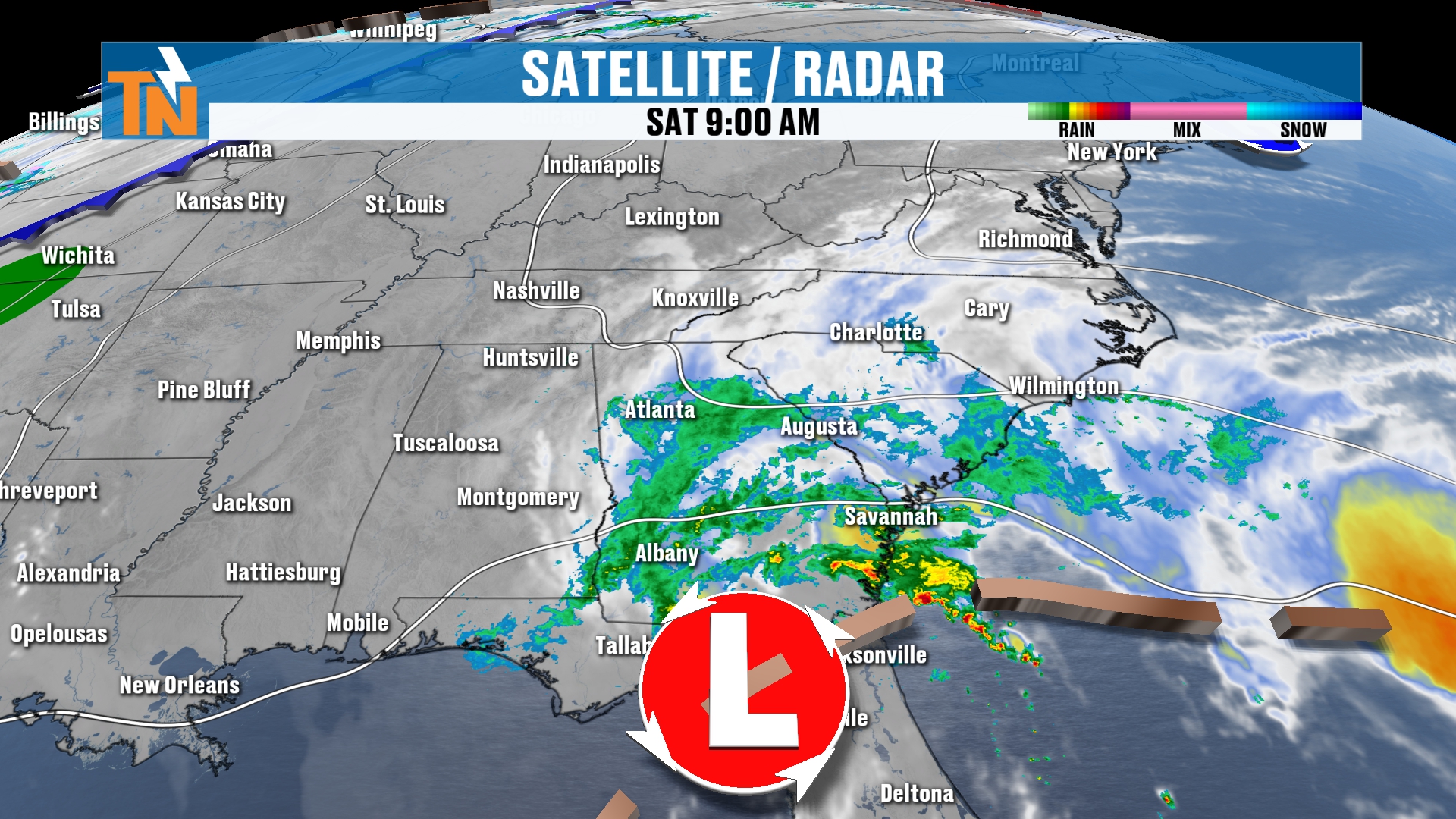
Come down into the mid-levels of the atmosphere. Where are the storms and disturbances? Well, we’ve got those two across the Pacific Northwest and the intermountain West. But we’ve also got an upper level low hanging out across parts of Florida that has been battering the coastal areas of Florida and parts of South Carolina and Georgia with a lot of heavy rainfall. It has brought a lot of flooding across that part of the country as well.
This upper level low has brought us the cloud coverage across the area, and that’s why we have some clouds hanging out with us. You can actually see these clouds from Townsend, the peaceful side of the Smokies, in the live view from this morning. That’s the mid-level cloudiness that’s going to stick with us throughout the day today thanks to that coastal low.
That coastal low possibly could bring us some light rain showers. I’m going to show you what it looks like on your Futurecast model, first on the big picture, and then we’ll bring it down locally and slow it way down.
Today: Mild With Clouds, Mid to Upper 60s
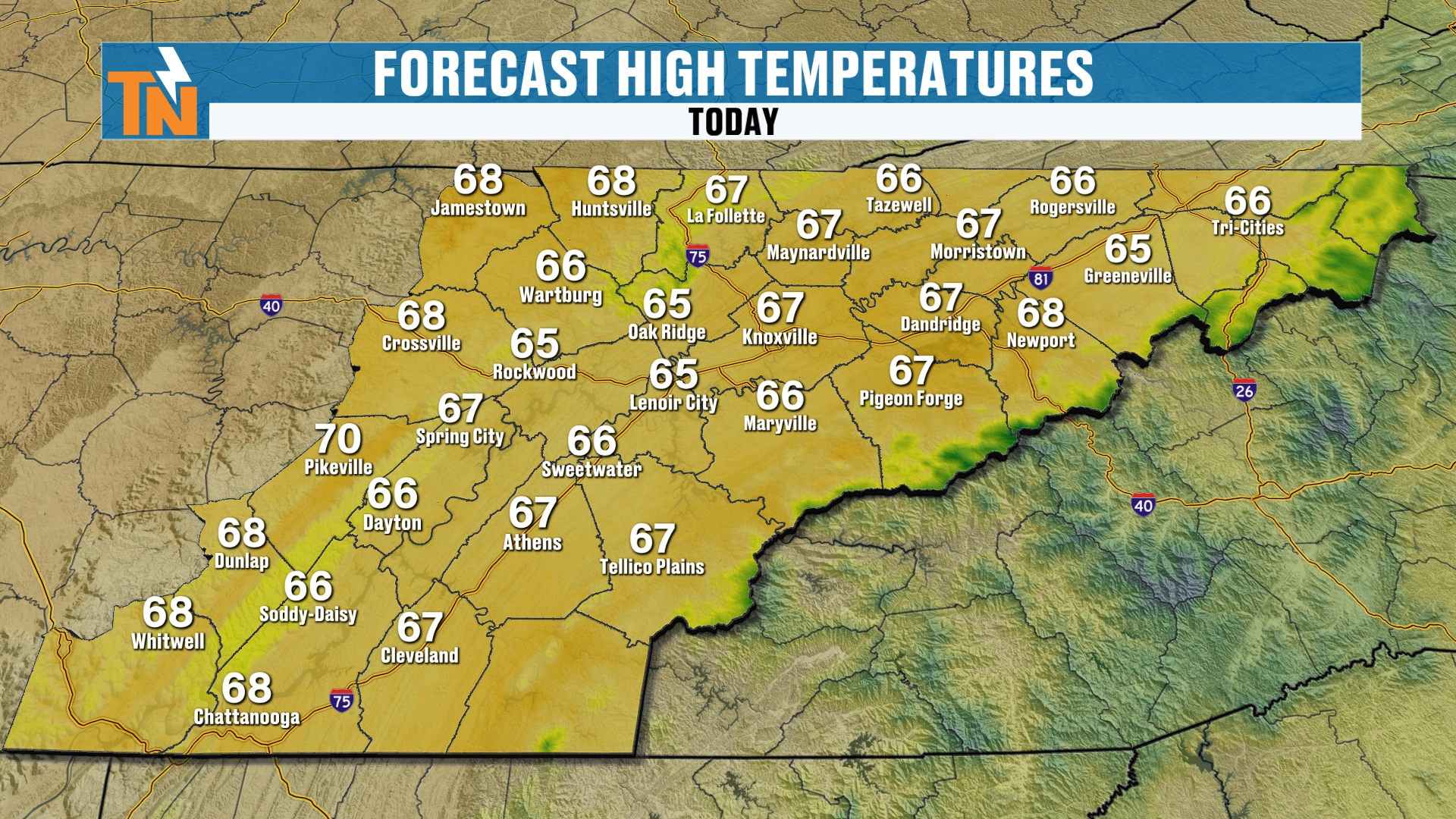
This morning we start off with temperatures in the 30s, 40s and even some 50s. Not a bad start to our day whatsoever. We’re trending much warmer, about 5 to 15 degrees warmer in some locations.
By lunchtime, we’re going to see temperatures climb into the low 60s. As we get into the afternoon, those forecast highs will be in the mid to upper 60s. So again, we’re still trending above average.
A little bit of a breeze today, kind of like what we’ve seen over the last couple of days. Probably a little bit more of a breeze across the highest peaks of the Smokies. If you happen to be in the national park, it’s probably going to be a little bit windier there.
UT vs. LSU: Game Day Forecast
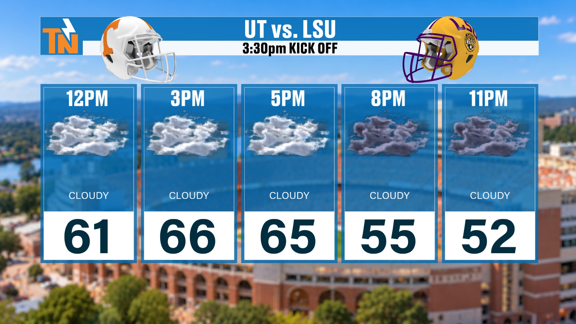
If you’re heading off to the UT vs. LSU football game, at noon we’re at 61. Kickoff at 3:30, we’re going to be right around 66. Then we cool down into the mid-50s by 8:00 toward the end of the game. And if you’re still out and about here on this Saturday night, at 11:00 we’re down to about 52.
Futurecast: Light Rain Possible Late Today Along I-81
All right, let’s continue with our Futurecast. Let’s pick it up this morning, I should say. Again, we’re going to have the cloud coverage hanging out with us, mid to high level clouds. Lunchtime, we’re likely to be on the dry side, but notice that moisture is starting to try to creep its way into the area.
At 3:00 today we could potentially see a couple of scattered light rain showers, mainly along the I-81 corridor. I’d say from Dandridge all the way through the Tri-Cities area, there’s a chance for a little bit of light rain toward the end of the day. But I don’t anticipate a whole lot, and the models aren’t picking up on a whole lot. A lot of that is going to evaporate, as we have some very dry air in place in the low levels anyway. So any rain that falls is going to be on the light side.
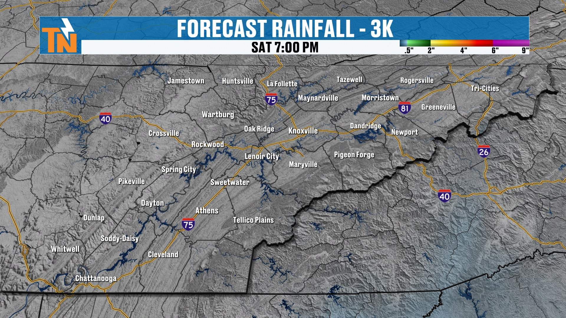
By Saturday evening, the rainfall forecast is basically empty across East Tennessee. That tells you how light and spotty anything today will be.
Sunday: Frost Gone, Another Fantastic Day
As we head through the overnight hours into Sunday morning, do we see any more rain coming in from that coastal low? Probably not a ton. I can’t rule out some light scattered rain showers across the I-81 corridor, but the model is not picking up on a whole lot of activity. As we get into the sunrise hour on Sunday, we stay mostly cloudy and mostly dry.
Morning low temperatures on Sunday, we’re really going to wipe away that frost and freezing. Temperatures will be in the 40s and 50s. Lunchtime temperatures will be back into the 60s, and afternoon highs will be back in the mid to upper 60s. So Sunday is going to be another fantastic day, very similar to what we experience today, with partly to mostly cloudy skies thanks to that coastal low.
Sunday Night Cold Front: Wet Roads Possible Early Monday
But remember, late Sunday into Monday we’ve got that cold front coming on through. I can’t rule out a couple of nuisance showers throughout the day on Sunday, staying mostly cloudy. There’s 7:00 Sunday night, and here comes our frontal boundary. It’s going to spill in with maybe just a little bit of light rain. It’s rather moisture starved, so we’re not looking at a whole lot of rainfall with that cold front. We should be on the drier side, but maybe some wet roads early Monday morning.
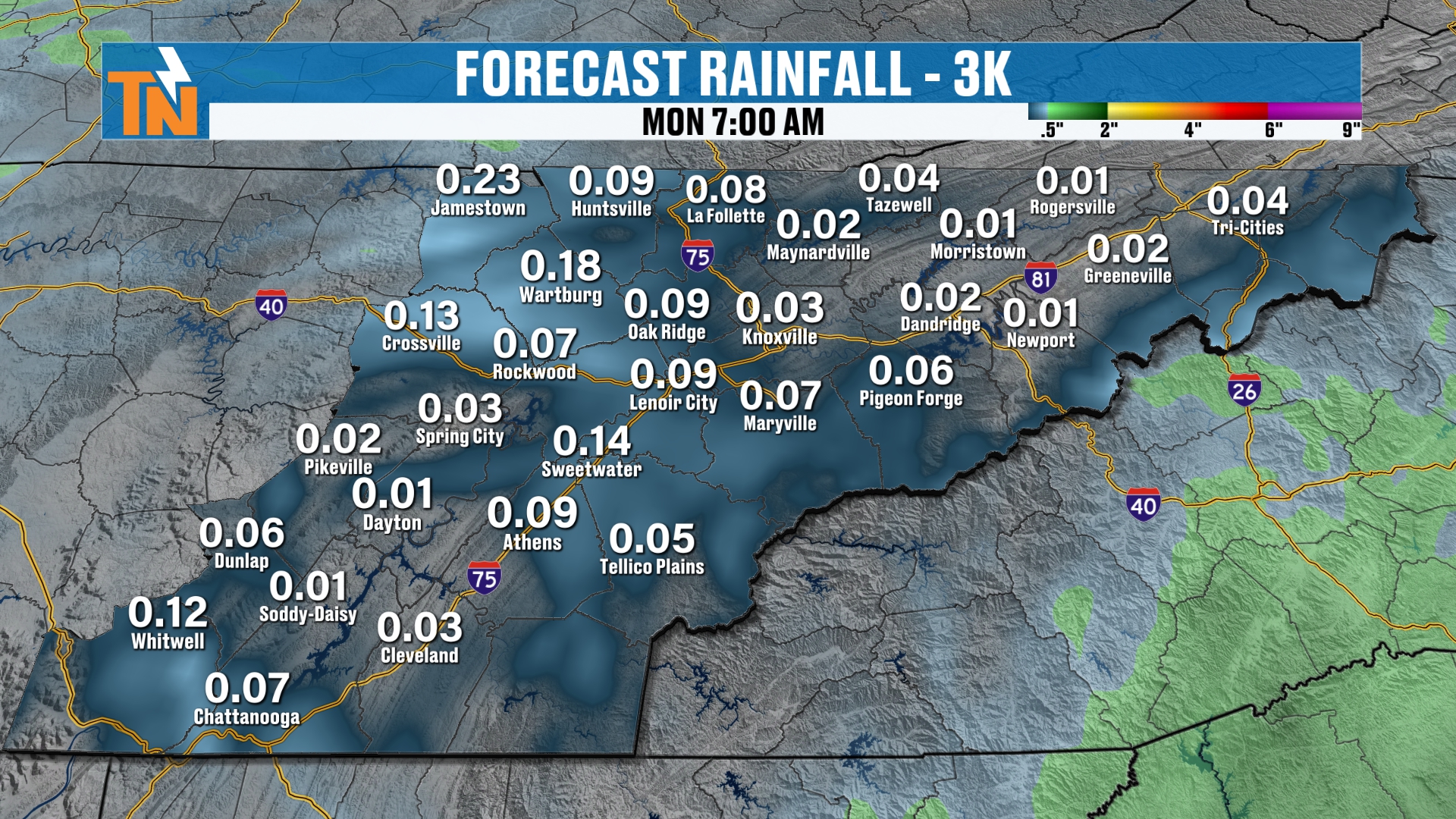
So in the grand scheme of things, from now through Monday morning, how much rainfall do we see? Well, not a lot. Most areas get less than a tenth of an inch of rain, but some areas may pick up upwards of about a quarter of an inch at best. We’ll see how the cold front progresses through time, but either way it’s going to stay on the warm side today and tomorrow.
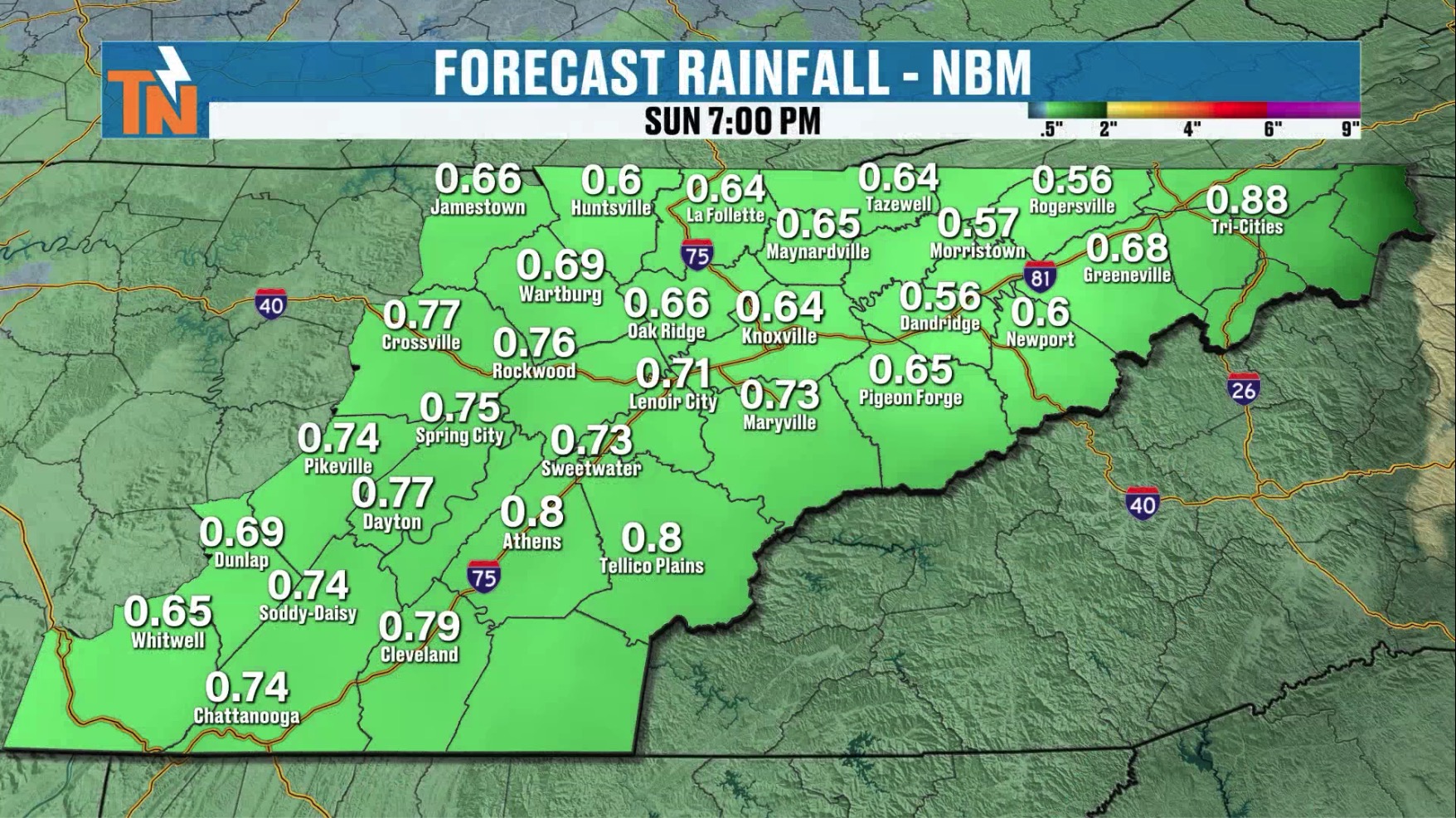
The NBM rainfall map for Sunday at 7 PM is another look at the rainfall guidance, with amounts from roughly half an inch to just under an inch across East Tennessee.
Colder Air Moves In: Monday Through Thanksgiving
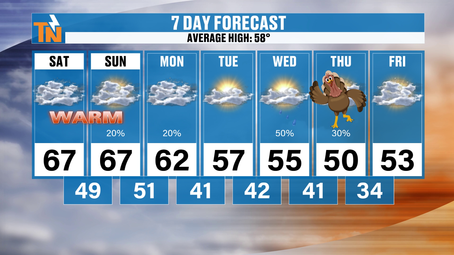
Then that cold front drops our temperatures into the low 60s on Monday. We continue that cold air infusion Tuesday and Wednesday, with highs only in the mid to upper 50s and lows in the 30s and 40s. So as we get into Thanksgiving Day, highs are going to be right around 50 degrees.
Wednesday or Thanksgiving Day? The Models Disagree
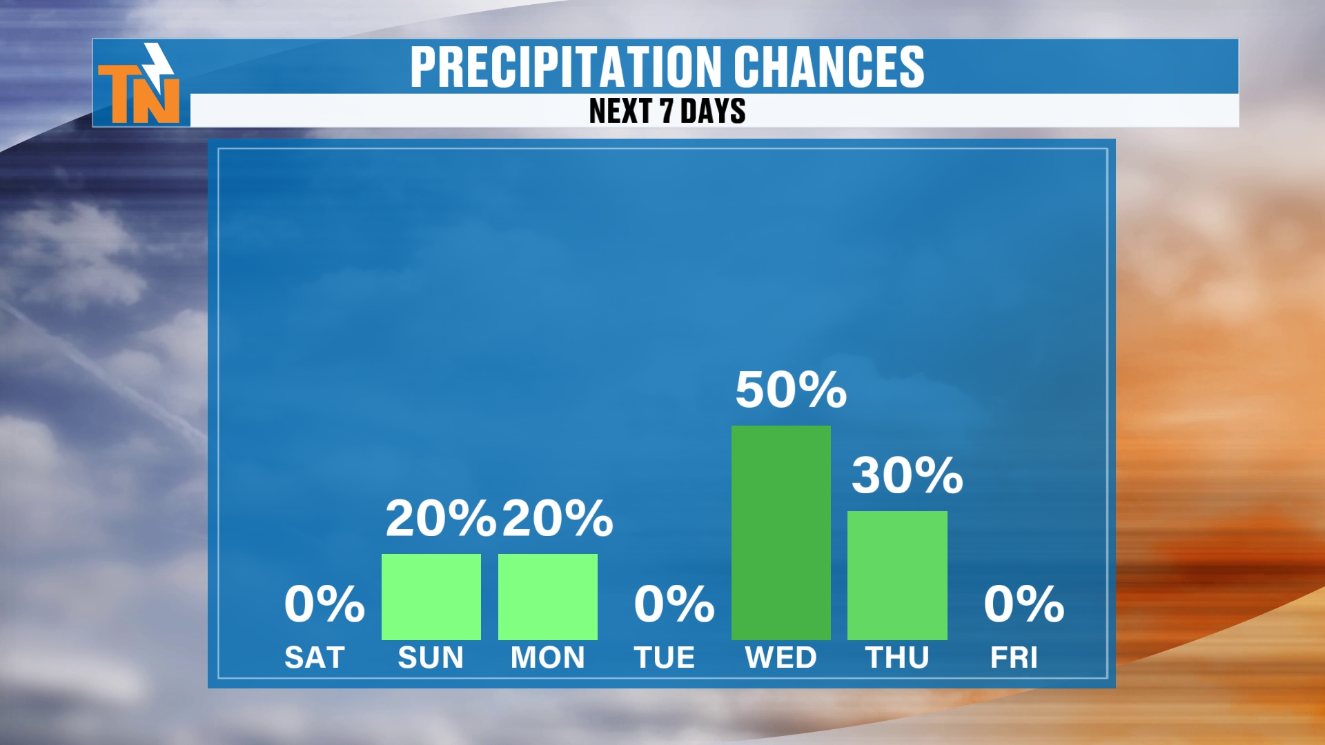
Notice Wednesday and Thursday, we have a chance for rain. So let me highlight those days for rainfall. I think Wednesday is probably the more likely day, although, as I mentioned, the GFS has more rain on Wednesday and the European has more rain on Thursday. Did I say that right? Did I say that right? Yes, I think I said that right.
Either way, one model has more rain on Thursday and one has more rain on Wednesday. One day will probably be wetter than the other. It just depends on the evolution of these upper level lows and how this all plays out.
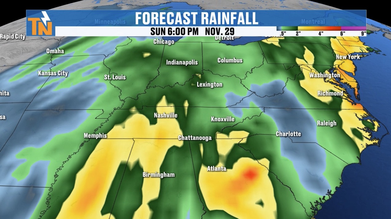
Here’s your rainfall forecast. Wednesday, Thursday, there’s Wednesday and Thursday. Friday, probably not going to see a whole lot. Saturday, Sunday, probably not going to see a whole lot either. But again, one model does have another wave coming through as we get into Sunday. So maybe Wednesday and Thursday, and then again on Sunday of this upcoming week.
A Stormy Pattern and a Colder Thanksgiving Weekend
Either way, we are still looking at a stormy weather pattern toward the end of Thanksgiving week and into the upcoming weekend, and maybe a couple of extra waves behind that system coming through Wednesday into Thursday.
It is going to present us with colder weather. As I mentioned with your 7-day forecast, we are talking about temperatures trending below average, probably upper 40s to low 50s, with potentially a cold rain on Wednesday and or Thursday.
Then our jet stream pattern will try to lift its way northward a little bit toward the end, and a ridge of high pressure back to our west will try to nudge its way back into the area. So do we see a nice little warming trend? I think the answer is yes.
Snowfall Potential: Higher Elevations Only
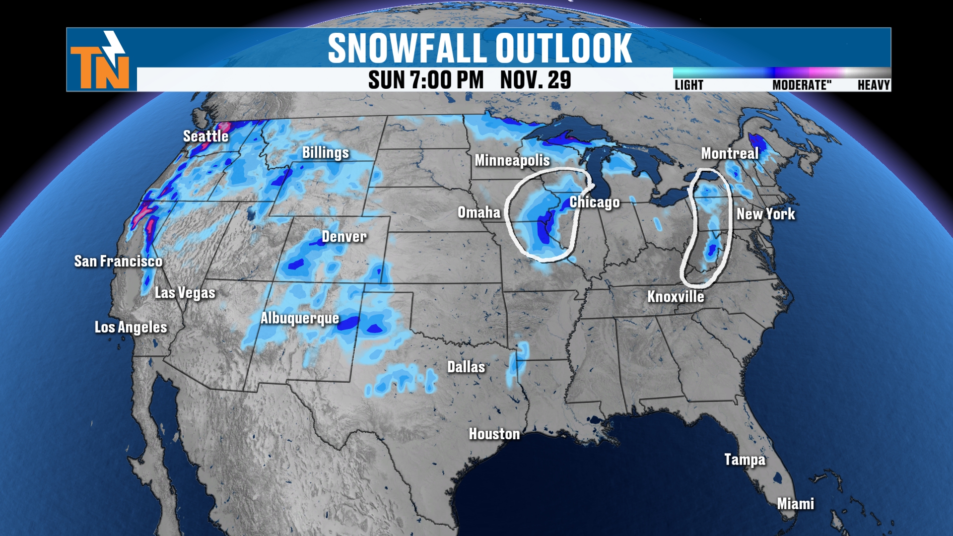
What about snowfall potential? I want to highlight this. I’ve circled a couple of areas, and the reason I did is because the models keep bringing back that signal for snowfall in these areas. Some days over the last several days I’ve shown you this and it didn’t show anything. Some days it’s shown something. So I wanted to circle the fact that the models keep bringing that signal back.
There is a potential, as we get into Wednesday, Thursday, Friday, Saturday and Sunday, that we could see some snowfall somewhere around the upper Midwest and maybe around the Appalachian region as well. That may include us here in East Tennessee. Maybe we get some wraparound moisture from one of those lows and it turns into some snowfall across the higher elevations.
It just looks like it’s going to be higher elevation snowfall. There are no major snow events on the way here for Thanksgiving week, and no major rain events, per se, but we will see increasing rain for sure.
Bottom Line
SATURDAY (TODAY): Mostly cloudy with mid to high level clouds from the coastal low. Morning starts in the 30s, 40s and 50s. 61 at noon, highs in the mid to upper 60s (66 at 3 PM). UT vs. LSU: 61 at noon, about 66 at the 3:30 kickoff, mid-50s by 8 PM and 52 by 11 PM. A little breeze, windier on the highest peaks of the Smokies. A couple of light, scattered showers possible late in the day mainly from Dandridge to the Tri-Cities along I-81.
SUNDAY: Mostly cloudy and mostly dry. Morning lows in the 40s and 50s, 60s at lunchtime and mid to upper 60s in the afternoon. A nuisance shower is possible during the day, and the cold front arrives around 7 PM Sunday night with maybe a little light rain.
MONDAY: Maybe some wet roads early. Most areas get less than a tenth of an inch of rain from now through Monday morning, with a few spots up to about a quarter of an inch. Highs drop into the low 60s.
TUESDAY: Colder air continues. Highs in the mid to upper 50s with lows in the 30s and 40s.
WEDNESDAY AND THURSDAY (THANKSGIVING): Highs in the mid 50s Wednesday and right around 50 on Thanksgiving Day, with a cold rain possible both days. Wednesday is probably the more likely rain day, but the GFS has more rain Wednesday and the European has more on Thursday.
FRIDAY AND THE WEEKEND: Black Friday looks drier, and the weekend probably is as well, though one model has another wave on Sunday. Colder, with a small signal for higher elevation snow. No major snow or rain events, but increasing rain overall.
The takeaway: stay warm and above average through Sunday, then a cold front brings cooler air and an active Thanksgiving week. Wednesday or Thanksgiving Day will be the wetter one, and we’ll keep narrowing it down.
For more daily updates, check out our Daily Forecast page. For longer-range outlooks, you can also check the Climate Prediction Center.
Don’t forget to LIKE, SHARE and SUBSCRIBE to the YouTube channel and hit the bell at the top. It really helps things out quite a bit.
Make sure you download my free East Tennessee Weather app for your cell phones, tablets and your smart TVs on Roku and Amazon Fire, and right here on YouTube. Check out the 24-hour weather channel. That’s the easiest, most convenient and most family-friendly way to get your weather forecast every single day.
I’m Meteorologist Mike Witcher, owner, operator and chief meteorologist for East Tennessee Weather. Be safe and be kind to each other, because life is short. Have a great Saturday!
eastTNweather — Weather When You Want It.