
Good morning and Happy Saturday.
Thanks for checking in with your East Tennessee morning weather update. The good news is we have a beautiful spring weekend ahead with warm temperatures and sunshine, but we are also tracking a strong storm system that will move into the region late Sunday night into Monday morning.
This system has the potential to bring strong to severe thunderstorms overnight Sunday, followed by heavy rain, gusty winds, and even a few snow showers on the back side of the storm as colder air rushes in.
Let’s walk through the forecast and what you can expect over the next few days.

A Gorgeous Saturday Across East Tennessee
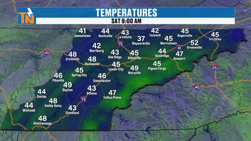
We are starting the morning on the chilly side with temperatures in the 30s and some pockets of low 40s, but sunshine and warm air will help temperatures rebound quickly today.
Thanks to a strong southwest flow ahead of the approaching storm system, temperatures will climb nicely this afternoon.
Saturday Forecast
- Morning lows in the 30s and 40s
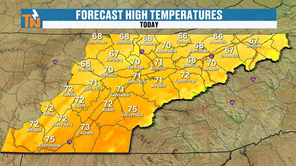
- Afternoon highs near 71 degrees
- Mostly sunny skies
- Light winds
Overall, it’s shaping up to be a fantastic spring day to get outside and enjoy the weather.
Strong Storm System Approaching the Southeast
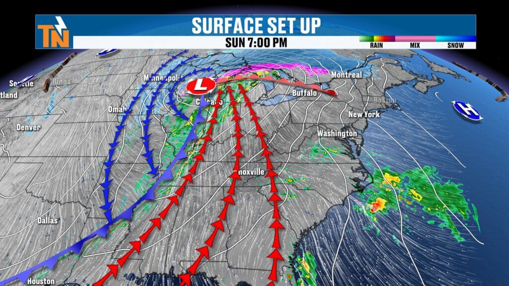
A deep upper-level trough moving out of the Plains will drive a strong cold front toward the Tennessee Valley late Sunday night.
This system will feature a powerful jet stream and strong atmospheric dynamics, helping fuel the development of thunderstorms.
At the surface, the setup will include:
- Low pressure tracking toward the Midwest
- Very warm and humid air surging northward ahead of the front
- Cold, dry air rapidly moving in behind the system
Moisture levels will increase significantly, with dew points rising into the 50s and low 60s, which provides fuel for thunderstorm development.
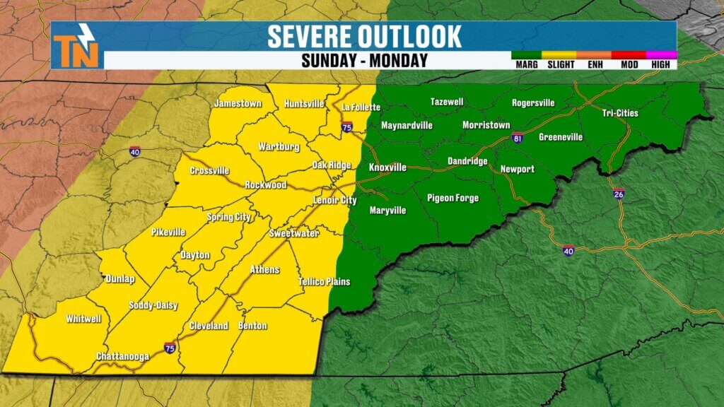
Severe Weather Risk Sunday Night into Monday Morning
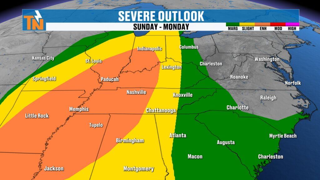
The Storm Prediction Center has highlighted a risk for severe storms across much of the Tennessee Valley.
The highest severe weather risk will be across western Tennessee, Kentucky, and parts of the Mississippi Valley, but East Tennessee is still included in the threat zone.
Severe Weather Risk Levels
- Level 2 risk for the Cumberland Plateau and western valley
- Level 1 risk for the remainder of East Tennessee
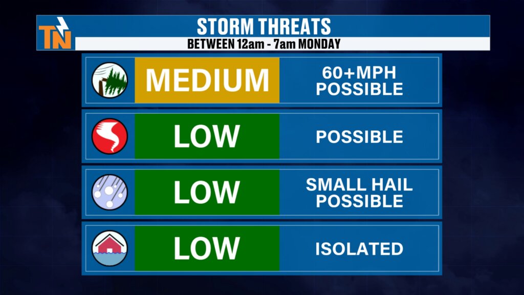
The main severe weather window will occur between midnight and about 7 AM Monday.
Primary Storm Threats
- Damaging straight-line winds
- Frequent lightning
- Heavy rainfall
Secondary threats include:
- Brief spin-up tornadoes (low risk)
- Small hail
- Isolated flooding
Timeline for Storms Sunday Night
Here’s how the storm system is expected to move through the region.
Sunday Evening
- Increasing winds
- Clouds thickening
Around Midnight
- Storms begin approaching western Tennessee
1–3 AM Monday
- Showers and thunderstorms move into East Tennessee
3–5 AM Monday
- Line of storms moves through the Tennessee Valley
Around 7 AM Monday
- Storm system exits the region
This timing means the Monday morning commute could be wet and slow-moving with leftover rain.
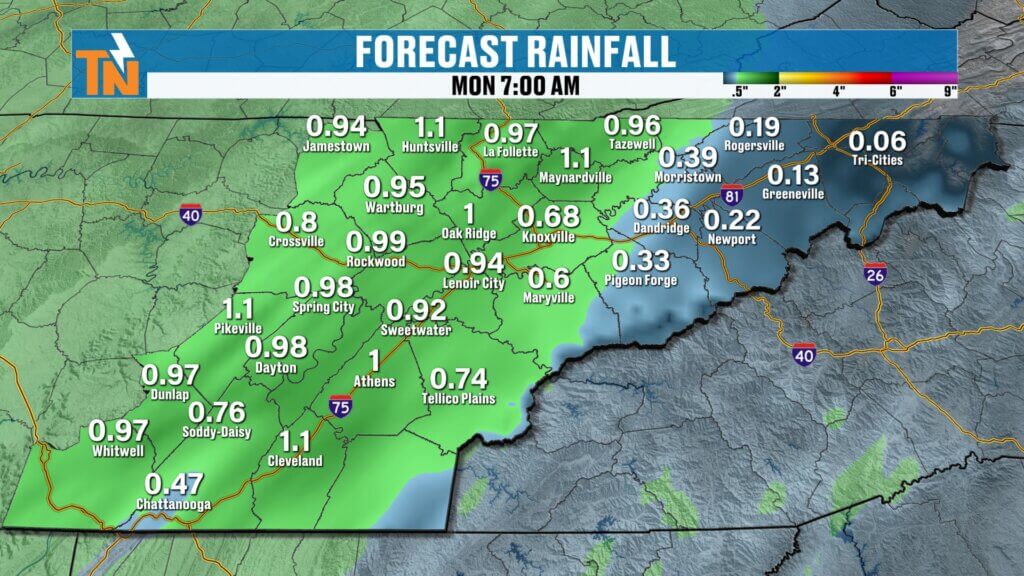

Heavy Rainfall Expected
Rainfall totals with this system will likely range between:
- 0.5 to 1 inch across East Tennessee
This rainfall will be beneficial for the region but should not cause major flooding issues.
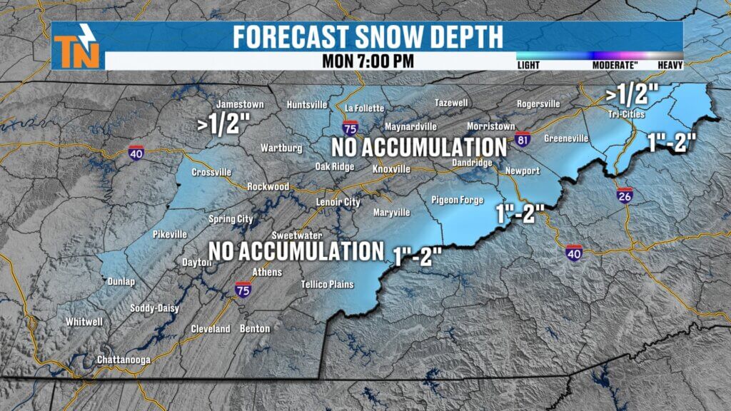
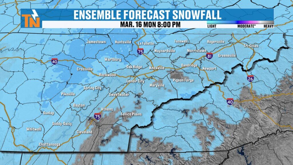
Rain May Change to Snow Monday
Once the cold front moves through, cold air will rush into the region quickly.
Temperatures will likely peak just after midnight ahead of the storm, then fall steadily throughout the day Monday.
As the colder air arrives, some locations could see rain transition to snow showers.
Snow Potential
- Valley locations: brief snowflakes possible
- Cumberland Plateau: potential for a light dusting
- Great Smoky Mountains: 1 to 2 inches possible in higher elevations
Ground temperatures remain relatively warm, so travel problems are not expected.
Still, the sight of snowflakes will be a reminder that Old Man Winter isn’t completely finished yet.
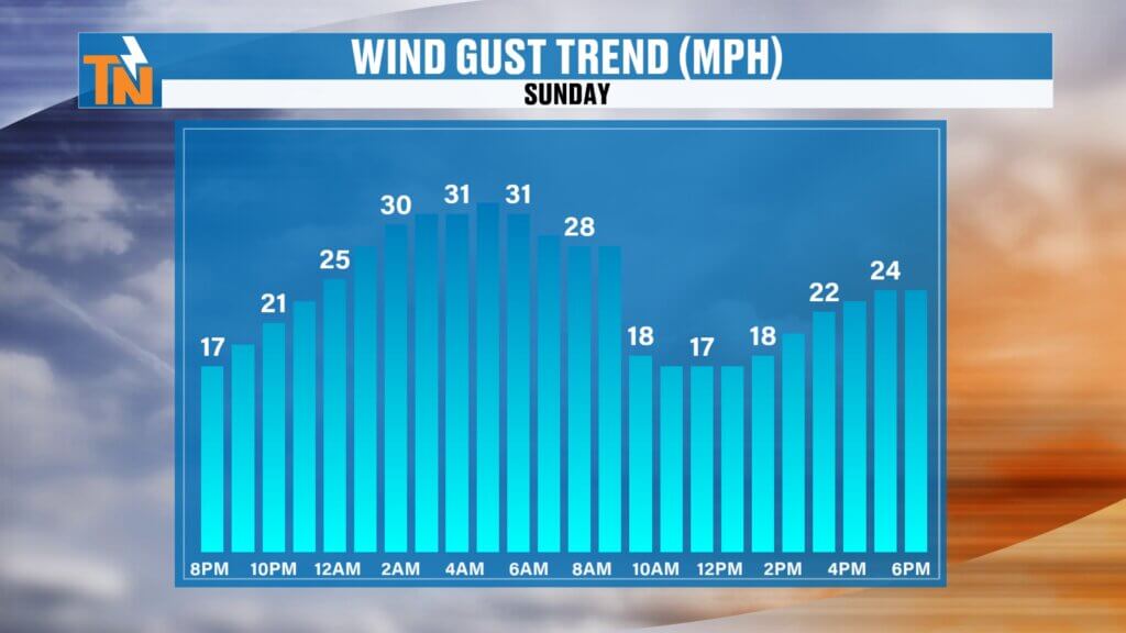
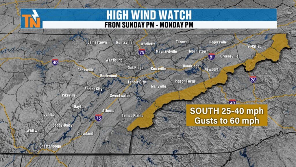
Strong Winds Expected with This System
Winds will increase significantly ahead of the cold front Sunday night.
A High Wind Watch is in effect from Sunday night through Monday night.
Expected wind conditions include:
- Sustained winds 25 to 40 mph
- Gusts potentially reaching up to 60 mph
After the cold front passes, winds will shift to the northwest and remain breezy through Monday.
Wind chill values Monday could drop into the 20s and 30s.
Sunday Night Cold Front Brings Rain and Storms
A deep trough moving out of the Plains into the Mississippi Valley will push a cold front toward the Southeast late Sunday night.
This system will strengthen as it approaches, bringing showers and thunderstorms into East Tennessee overnight Sunday into early Monday morning.
Timeline for the Next Storm System
Sunday Evening
- Increasing clouds
- Breezy conditions
- Still warm
Late Sunday Night
- Cold front approaches from the west
- Rain showers developing
Early Monday Morning
- Widespread rain and possible thunderstorms
Most of the rain will occur during the Monday morning timeframe.
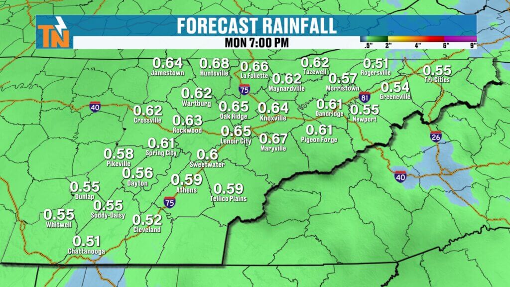
Rainfall Totals from the Next System
This system should bring around a half inch of rainfall across the region, though some areas could see slightly higher totals.
While this rainfall will be beneficial, flooding concerns are not expected at this time.
Light Snow Possible in Higher Elevations
As colder air arrives, some light snow showers could develop Monday, especially across:
- The Cumberland Plateau
- The Smoky Mountains
- Higher elevations of East Tennessee
Ground temperatures remain relatively warm, so travel issues are not expected.
Colder Air Arrives Monday
Much Colder Weather Early Next Week
Temperatures Monday will fall steadily throughout the day as colder air moves in.
Monday Temperature Trend
- Morning temperatures near 46 degrees
- Afternoon temperatures falling into the upper 30s
By Tuesday and Wednesday mornings, temperatures could drop into the low to mid 20s.
Warmer Weather Returns Later Next Week
The colder weather will not last long.
By the second half of the week, temperatures will rebound quickly.
Late Week Outlook
- Thursday: highs in the 60s
- Friday: mild and pleasant conditions
Spring warmth will return once again across East Tennessee.
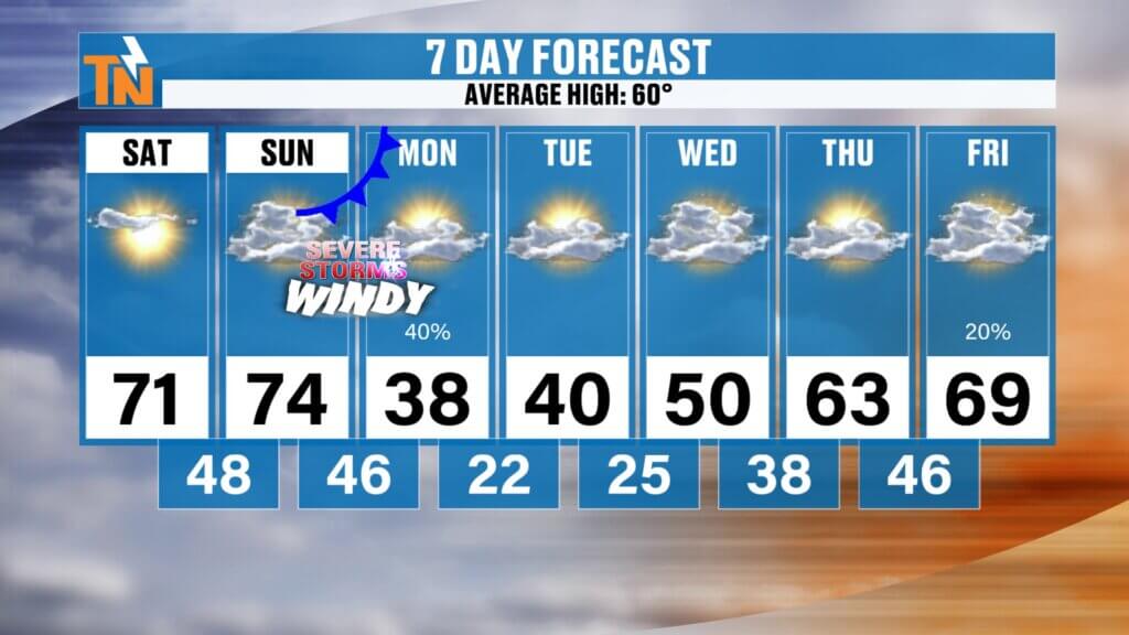
East Tennessee 7-Day Weather Outlook
- Saturday: Sunny and warm, high near 71°
- Sunday: Warm and breezy, high near 74°
- Sunday Night: Strong storms possible overnight
- Monday: Rain ending early, falling temperatures, possible snow showers
- Tuesday: Cold with morning lows in the 20s
- Wednesday: Chilly but dry
- Thursday – Friday: Warmer weather returns with highs in the 60s
Final Thoughts
Enjoy the beautiful spring weather this weekend because a strong storm system will arrive late Sunday night, bringing the potential for severe storms, heavy rain, and strong winds.
Behind the system, temperatures will drop quickly Monday and some areas may even see snow showers before colder air settles into the region.
Stay weather aware Sunday night and make sure you have a way to receive weather alerts.
Have a great Saturday.