
Happy Tuesday, everybody.
Thanks for checking in this morning.
After several days of high humidity, tropical-like downpours, and even a few strong thunderstorms, we are finally on the backside of that storm system and headed into a much more comfortable stretch of weather.
And honestly?
For late June in East Tennessee, this kind of air doesn’t stick around long.
So enjoy it.
Let’s break it down.
Heavy Rainfall Soaks Parts of East Tennessee Overnight
Yesterday turned out to be another warm and humid summer day across the region.
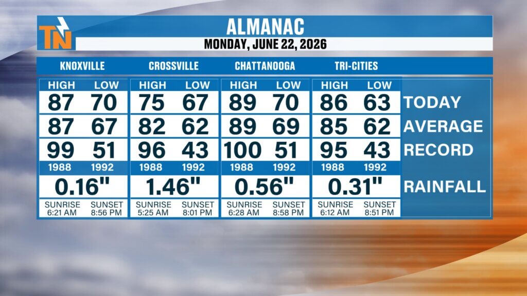
Knoxville officially topped out at 87 degrees, right near average for this time of year.
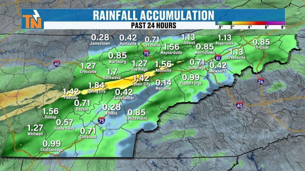
At McGhee Tyson Airport, rainfall totals came in at just 0.16 inches.
But that does not tell the whole story.
Some areas picked up much more.
Crossville saw nearly 1.5 inches of rain.
A large swath from Knoxville west through Lenoir City, up toward Spring City, and east toward Pikeville picked up over an inch in spots.
That’s important because many of those areas are still dealing with drought conditions.
And every bit of rain helps.
Lingering Showers Early, Then Improving Conditions
As we start the day, there are still a few lingering showers across Upper East Tennessee and parts of Sevierville and Sevier County.
Clouds and fog are hanging tough this morning too.
That’s expected after a night of heavy rainfall and saturated ground.
But the trend today is improvement.
Through lunchtime:
Mostly cloudy skies remain.
By this afternoon:
Clouds begin to break.
By this evening:
Much more sunshine and noticeably drier air settles in.
That’s the transition.
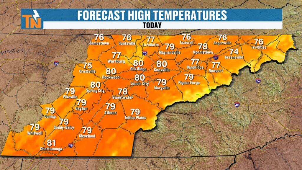
Cooler Air Settles Into East Tennessee Today
This morning feels noticeably better.
Temperatures are starting out in the 60s and low 70s.
That’s a little cooler than yesterday.
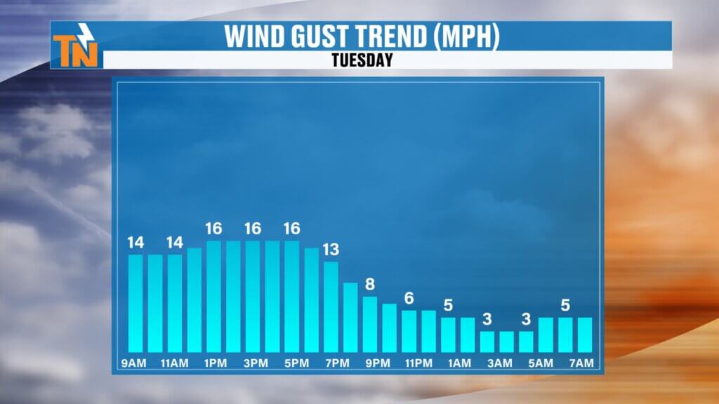
Winds are still a bit breezy early on, but they’ll relax through the afternoon.
And with a northerly flow behind the cold front, that cooler and drier air continues filtering in.
Forecast highs today:
Upper 70s to low 80s.
That’s below average for late June.
And honestly, pretty hard to beat.
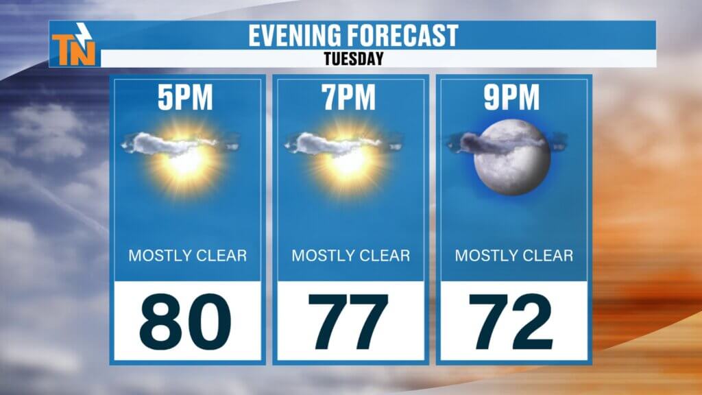
Comfortable Weather Returns Tonight
By 7 PM, temperatures fall into the upper 70s.
And more importantly:
Humidity begins dropping.
Dew points will steadily fall through the evening.
That’s what changes how the air feels.
It’s one thing to have warm temperatures.
It’s another thing entirely when the humidity backs off.
That’s what makes tonight feel so good.
If you’ve got dinner plans, yard work, baseball practice, or just want to sit outside, tonight is one of those nights to take advantage of it.
Wednesday Looks Even Better
Tomorrow may actually be the best weather day of the week.
Highs around 85 degrees.
Lower humidity.
Plenty of sunshine.
Comfortable morning.
Comfortable evening.
Pretty much picture-perfect June weather for East Tennessee.
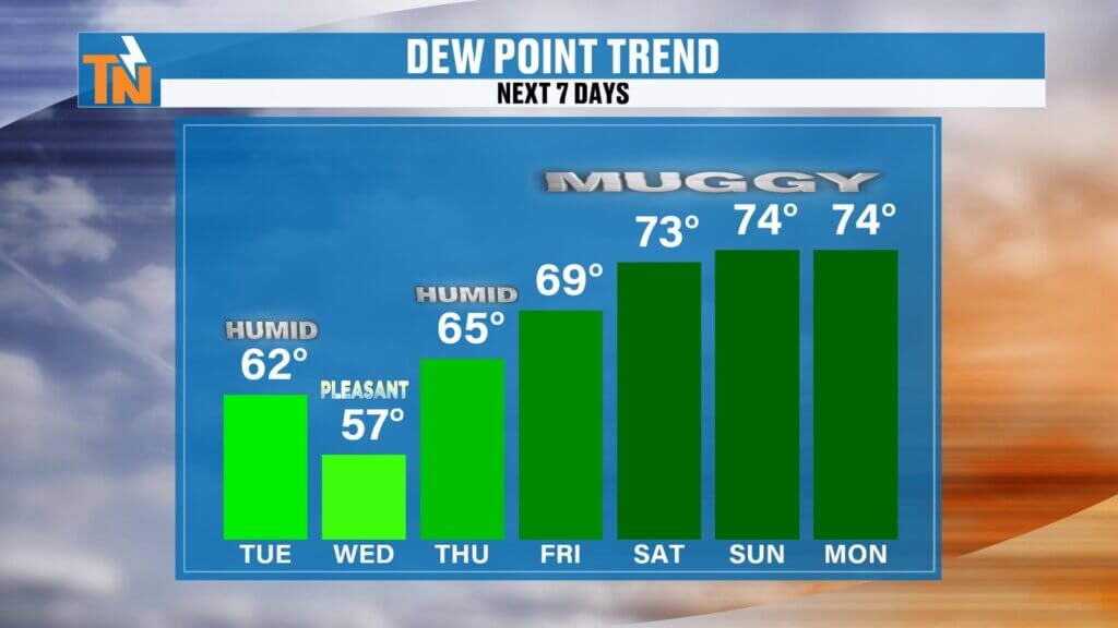
Humidity Returns Late Week
The break doesn’t last forever.
By Thursday, moisture starts creeping back in.
And by Friday into the weekend, the mugginess returns.
That means:
- Higher dew points
- More instability
- More heat
- More scattered storms
Classic summertime weather.
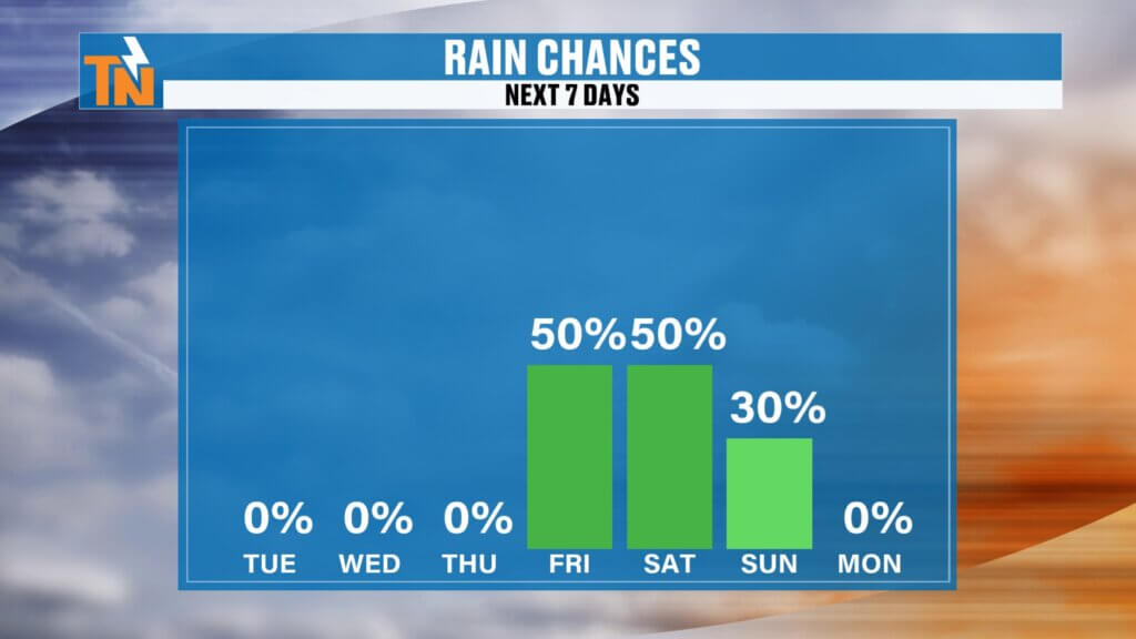
Rain Chances Stay Low Until the Weekend
The good news?
Rain chances stay very limited through Friday.
We may see an isolated pop-up shower near the Tennessee/Kentucky border or in the higher elevations, but most of East Tennessee stays dry.
Better storm chances return:
Saturday
Sunday
Early next week
That’s when a few disturbances begin working through the region.
Not washout days.
But enough to bring scattered showers and storms back into the forecast.
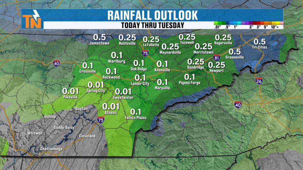
Rainfall Outlook: Who Gets the Most?
Over the next seven days:
Best rainfall potential:
- Cumberland Plateau
- Higher elevations of the Great Smoky Mountains
- Upper East Tennessee
Lower rainfall totals:
- Southern Valley
- Chattanooga corridor
- Southern foothills
That’s where rainfall may stay more limited.
We’ll also get a fresh look at the latest drought conditions this Thursday when the updated U.S. Drought Monitor is released.
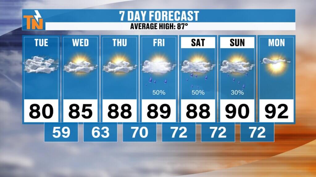
East Tennessee 7-Day Forecast
Tuesday
Clouds early, sunshine later
Cooler and drier
High: 80°
Wednesday
Beautiful weather
Low humidity
High: 85°
Thursday
Warmer, humidity returns
High: 87°
Friday
Hotter and muggier
High: 89°
Saturday
Scattered storm chances increase
High: 89°
Sunday
Warm and humid
Storm chances continue
High: 88°
Monday
Typical summer pattern
Spotty storms possible
High: 87°
Bottom Line
The tropical feel is fading.
The heavy rain is moving out.
And for the next 48 hours, East Tennessee gets a nice break.
Lower humidity.
Cooler mornings.
Comfortable evenings.
But don’t get too used to it.
Because the heat and mugginess are already waiting to make a comeback by the end of the week.
Enjoy this stretch while it’s here.
It’s a good one.