
Happy Monday, everybody.
Sure hope you had a great weekend.
Father’s Day weekend and the first official weekend of summer wrapped up with classic East Tennessee weather — warm, humid, and right on average for this time of year.
Knoxville topped out at 88 degrees Sunday.
The average high is 87.
The record? 99.
And now the focus shifts to an active weather day.
Because the storms we’ve been talking about all weekend are finally here.
Let’s break it down.
East Tennessee Storm Threat Arrives Today
Today is the day.
We’ve been tracking this setup for several days now, and showers and thunderstorms will be increasing across East Tennessee through the day.
There are two possible rounds of storms.
Round one is already developing this morning across Middle Tennessee, mainly near Nashville.
That cluster is moving east and will determine a lot about what happens later today.
Here’s why that matters:
If those morning storms hold together or redevelop as they move east, they could bring rain into East Tennessee earlier than expected.
If they weaken?
That leaves more energy in the atmosphere for stronger storms later.
That’s the balancing act.
Why This Setup Is Complicated
This is one of those classic summer forecast challenges.
The atmosphere is loaded with moisture and instability.
But how storms evolve this morning will directly impact this afternoon and evening.
Meteorology is often about atmosphere management.
Does the morning round “work over” the atmosphere?
Or does it leave fuel behind?
That’s what we’re watching closely.
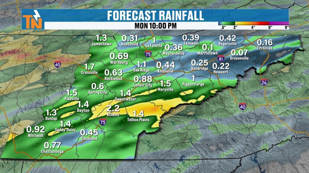
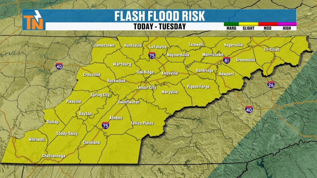
Flooding and Flash Flooding Risk Elevated
The Weather Prediction Center has East Tennessee under a Level 2 flood risk today.
That means:
- Localized flash flooding is possible
- Tropical-like rainfall rates are likely
- Repeated storms over the same area could create water issues quickly
This is what we call training storms.
That’s when multiple storms move over the same location repeatedly.
That’s when flash flooding becomes dangerous.
Not everyone floods.
But the areas that do could see problems quickly.
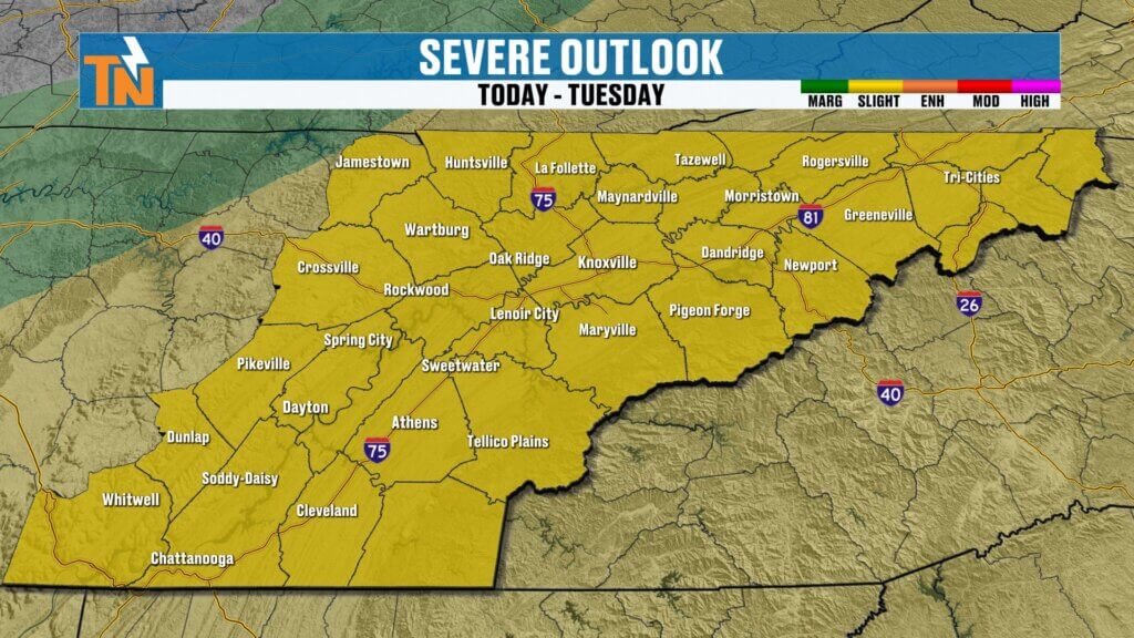
Severe Storm Risk Upgraded for East Tennessee
The Storm Prediction Center has upgraded East Tennessee into a Level 2 severe weather risk.
That’s an increase from what we were discussing yesterday.
Main threats today:
- Damaging wind gusts
- Heavy rainfall
- Frequent lightning
- Small tornado risk
- Isolated hail
And while tornadoes are not the primary concern, there is enough spin in the atmosphere that we have to respect the possibility.
Wind remains the biggest concern.
And remember:
In East Tennessee, damaging straight-line winds often create more problems than tornadoes.
Futurecast Timeline: Here’s What to Expect
Using the latest high-resolution guidance, this is how today currently looks.
Morning through Noon:
Mostly quiet for many areas, but scattered showers could begin to fire.
Early Afternoon (1 PM – 3 PM):
Storms begin organizing.
Mid to Late Afternoon (3 PM – 6 PM):
Storm coverage increases.
This is the first big window for stronger storms.
Evening (5 PM – 8 PM):
This currently looks like the best window for widespread storms moving through.
This is your highest alert period right now.
Late Evening into Overnight:
Storms gradually weaken and shift east.
Again — this timeline could shift depending on what happens this morning.
Monday Starts Warm, Muggy, and Unstable
It’s another warm and humid start.
Morning temperatures are already in the 70s.
And when you step outside?
You feel it immediately.
Humidity is high.
The atmosphere is primed.
Winds will stay breezy and gusty through the day as the system approaches.
Forecast highs today:
- Low to mid 80s
- Cloud cover and rain keep temperatures down a bit
- Still humid and sticky all day
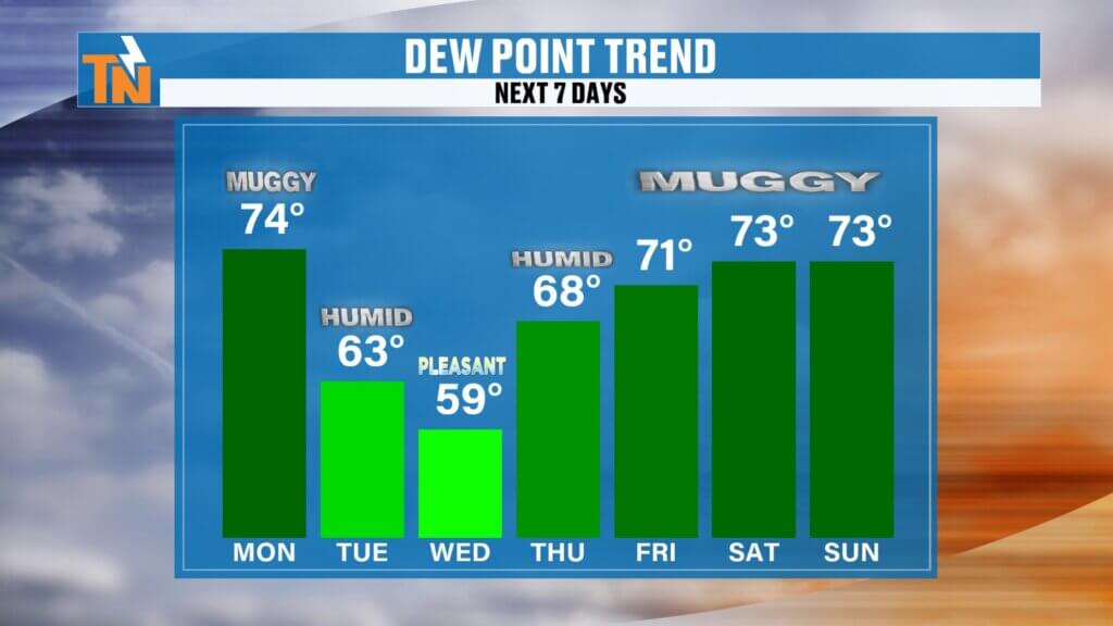
Drier Air Returns Tuesday and Wednesday
The good news?
This system moves out tonight.
And behind it comes some drier air.
Dew points begin falling overnight.
That sets up:
- Lower humidity Tuesday
- Lower humidity Wednesday
- More comfortable mornings
- Less storm coverage
Not completely dry forever.
But definitely better.
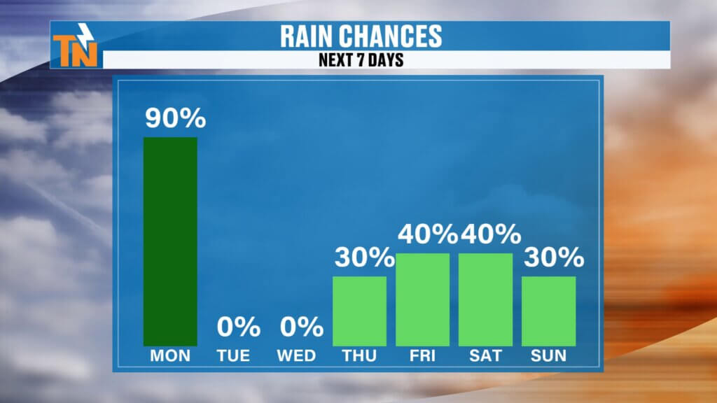
Rain Chances This Week
Monday:
Highest rain and storm coverage
Tuesday:
Mostly dry
Wednesday:
Mostly dry
Thursday:
Typical summer pop-up storms
Friday:
Slightly higher storm coverage
Weekend:
Hotter and mostly dry
Higher elevations like the Cumberland Plateau and the Great Smoky Mountains will likely have the better chances later in the week.
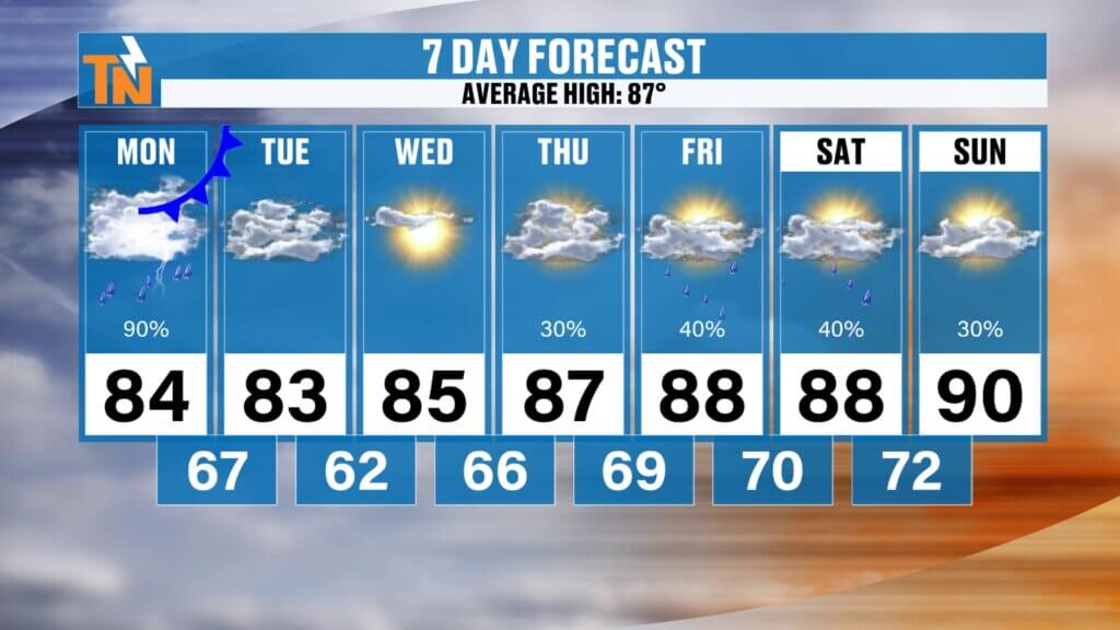
East Tennessee 7-Day Forecast
Monday
Strong storms possible
Heavy rain possible
Flooding concerns
High: 84°
Tuesday
Less humid
Mostly dry
High: 83°
Wednesday
Pleasant and quiet
High: 84°
Thursday
Warmer
Spotty storms
High: 87°
Friday
Hotter and muggy
Storm chance
High: 88°
Saturday
Summer heat builds
High: 89°
Sunday
Near 90°
Hot and humid
High: 90°
Bottom Line
Today is an active weather day.
Strong storms are possible.
Heavy rain is likely.
Flooding is possible.
Not everyone gets severe weather.
Not everyone floods.
But everybody needs to stay weather aware.
This is one of those days where the radar matters.
Track storms live with the East Tennessee Weather app.
Interactive radar.
Lightning alerts.
Push notifications.
Live severe weather coverage if needed.
And you know if things ramp up, I’ll be right here.
Have a great Monday, stay weather aware, and keep checking back in.