
Good morning and happy Monday, everybody.
Thanks for checking in this morning, and I hope you had a great weekend.
After a stormy and soggy Sunday across East Tennessee, we’re finally catching a break. Yesterday brought widespread showers, thunderstorms, and plenty of tropical humidity. Officially at McGhee Tyson Airport, we picked up 0.19 inches of rainfall, while temperatures climbed to 87 degrees.
But now, things are changing.
And honestly, it’s a welcome change.
A cold front has pushed south of East Tennessee this morning, and behind it, cooler and much drier air is beginning to filter into the region. It won’t feel dramatically different right out the door this morning, but by this afternoon and especially over the next few days, you’ll absolutely notice it.
Let’s break it all down.
Cooler, Drier Air Settles Into East Tennessee
The weather pattern is shifting.
A trough digging southward across the Ohio Valley will reinforce the cooler air over the next 24 to 48 hours. This setup will allow northerly winds to continue pulling in lower humidity and more comfortable temperatures.
Behind yesterday’s cold front:
- Rain-free weather returns
- Dew points begin dropping
- Humidity levels improve
- Temperatures settle below average
For mid-June in East Tennessee, this is a pretty nice setup.
And honestly? We’ll take it.
Monday Morning Forecast: Comfortable Start
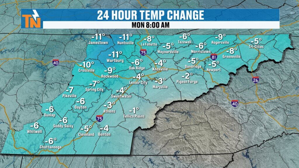
We’re waking up to temperatures in the 50s and 60s across East Tennessee.
While humidity is still hanging around a bit this morning, it’s already lower than where we were over the weekend.
Compared to this time yesterday:
- Temperatures are running noticeably cooler
- Humidity is beginning to ease
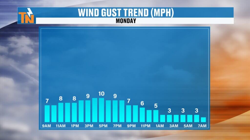
- Winds remain light
It’s a much better start to the day.
Monday Afternoon Forecast: Sunshine and Comfortable Conditions
Today is shaping up to be one of the better weather days we’ve had in a while.
Expect:
- Mostly sunny skies
- A few fair-weather clouds
- Light winds
- Comfortable humidity
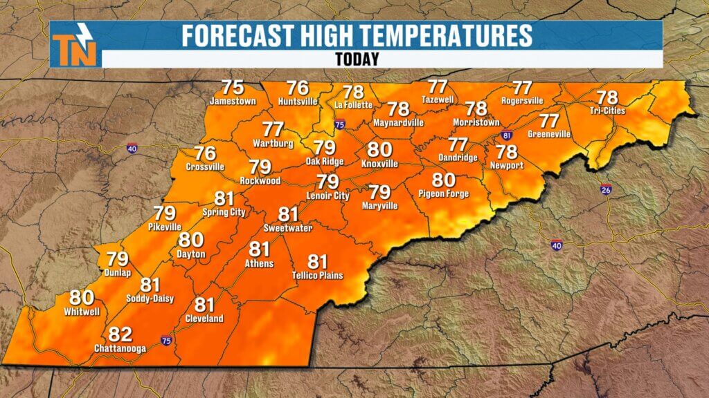
High temperatures will top out in the upper 70s to low 80s.
That’s below the seasonal average of 86 degrees for this time of year.
Not bad at all for mid-June.
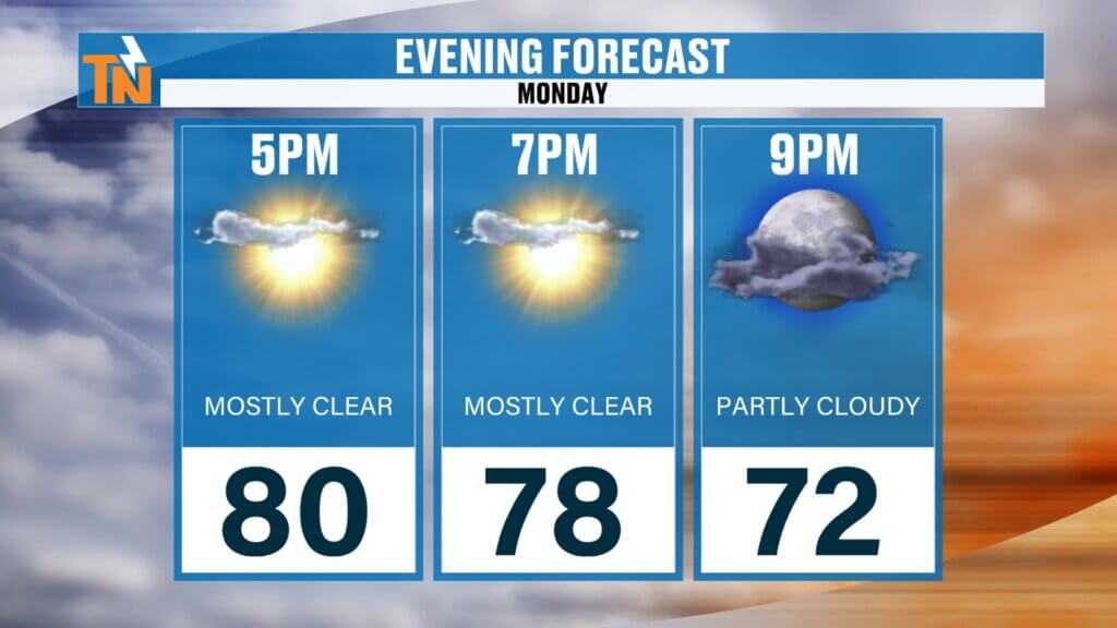
Perfect Weather for Monday Evening Plans
If you’ve got outdoor plans this evening, tonight looks fantastic.
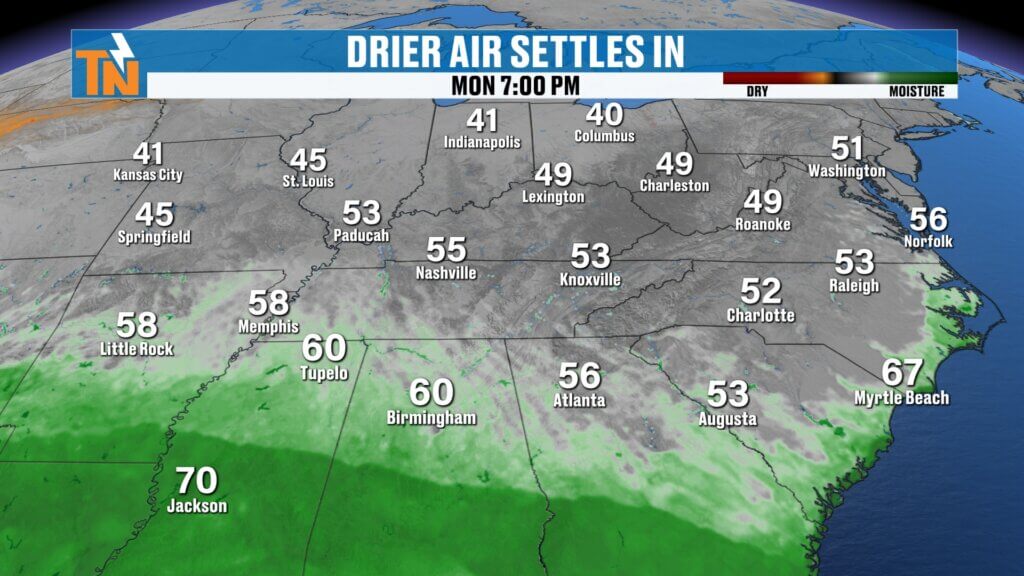
By 7 PM:
- Temperatures near 78°
- Mostly sunny skies
- Lower humidity
- Light breeze
This is excellent weather for:
- Evening walks
- Outdoor dining
- Yard work
- Summer baseball
- Family time outside
Take advantage of it.
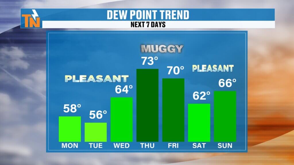
Pleasant Stretch Through Midweek
The comfortable weather sticks around through Wednesday.
This stretch brings:
- Lower humidity
- Cooler nights
- Pleasant afternoons
- Rain-free skies
Forecast highs:
Monday: Low 80s
Tuesday: Low 80s
Wednesday: Mid 80s
This will be one of the better stretches of weather we’ve seen lately.
Humidity Returns Thursday and Friday
The break doesn’t last forever.
By Thursday, the pattern begins shifting again.
Moisture starts surging back northward, and that means:
- Rising humidity
- More cloud cover
- Increasing rain chances
- Locally heavy downpours
This next system looks fairly productive.
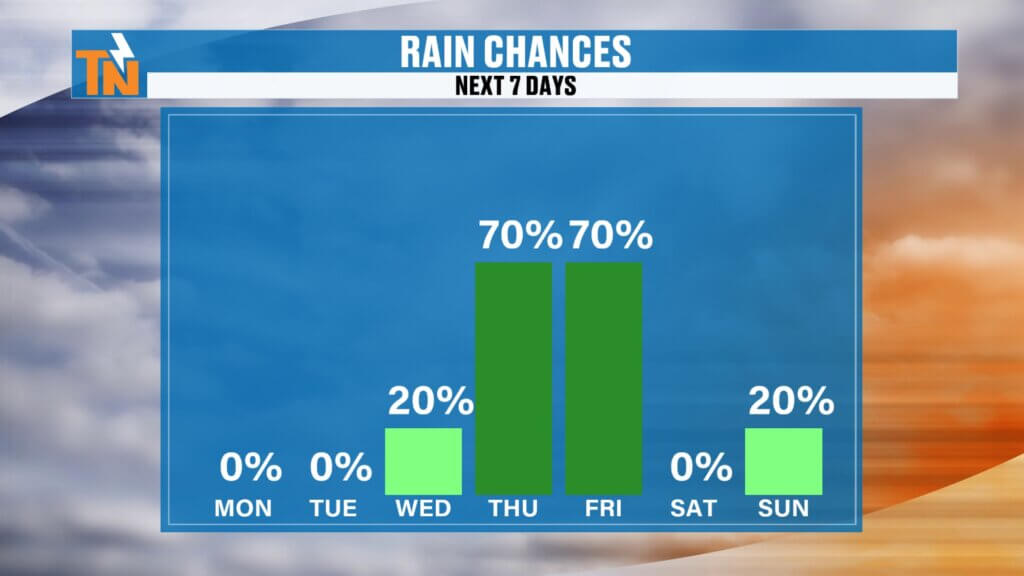
Heavy Rain Potential Late Week
Thursday and Friday will bring our next significant rainmaker.
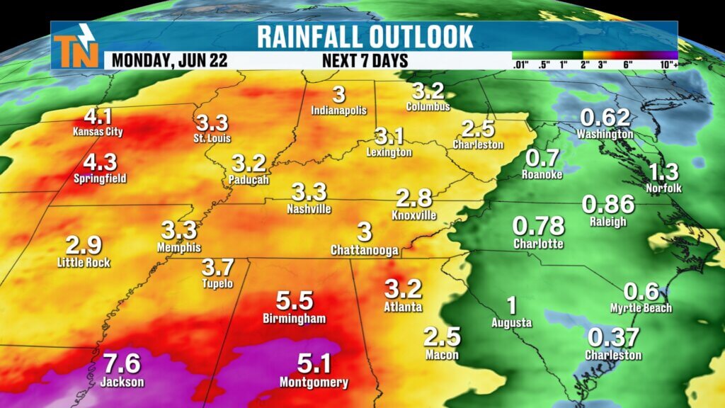
Forecast models continue to show widespread rainfall developing as moisture increases across the Tennessee Valley.
Rainfall potential:
Thursday into Friday:
- 1 to 2+ inches possible
By next Sunday into Monday:
- Additional rainfall possible
Total 7-day rainfall:
- 2 to 3 inches possible in some areas
This is beneficial rain overall, especially considering how dry we’ve been at times, but localized heavier downpours could create some brief flooding issues.
Weekend Forecast Preview: Looking Pretty Good
The good news?
Next weekend is looking much better.
Behind the late-week rain:
- Another push of cooler air moves in
- Humidity drops again
- Temperatures settle into the low to mid 80s
- More comfortable conditions return
That’s shaping up nicely for outdoor plans.
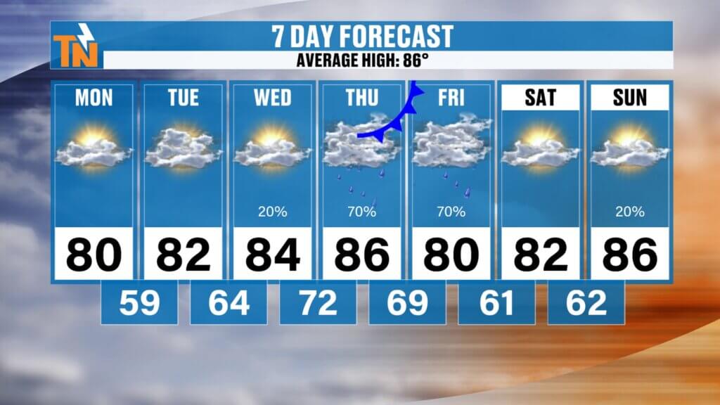
East Tennessee 7-Day Forecast
Monday
Mostly sunny and comfortable
High: 81°
Tuesday
Sunny and pleasant
High: 82°
Wednesday
Warm, seasonable, and dry
High: 85°
Thursday
Humidity increases
Scattered showers develop
High: 86°
Friday
Widespread showers and storms
Heavy rain possible
High: 82°
Saturday
Partly sunny and comfortable
High: 84°
Sunday
Mostly dry with slight rain chances returning
High: 84°
Bottom Line
The story this week is all about the swings.
Short-term:
- Cooler
- Drier
- More comfortable
Late week:
- Hotter
- More humid
- Rainier
Weekend:
- Comfortable again
For mid-June, that’s about as classic East Tennessee as it gets.
Enjoy these next three days.
They’re going to feel fantastic.
And as always, make sure you keep up with the latest forecast, interactive radar, and weather alerts using the East Tennessee Weather app.
Have a great Monday, everybody.