
Happy Thursday, everybody.
I sure hope you have a great day today.
Well… she’s back.
I’m talking about the air you can wear.
If you stepped outside this morning, you felt it immediately. The humidity is back in a big way across East Tennessee, and it’s only going to get thicker as tropical moisture surges northward into the Tennessee Valley.
Yesterday was the beginning of that transition.
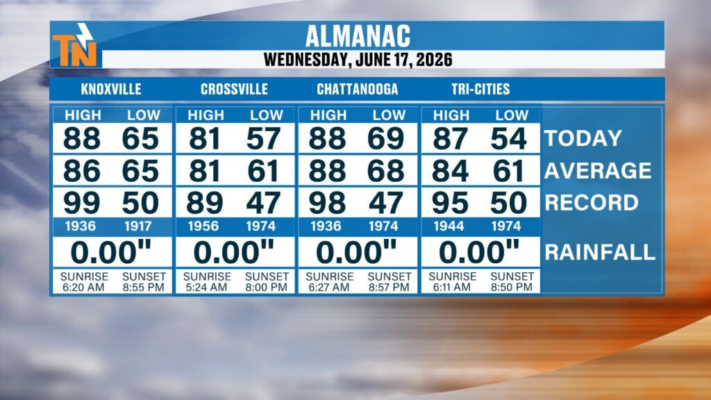
Knoxville topped out at 88 degrees, Chattanooga hit 87, and Crossville made it to 81. It was warmer, muggier, and today we turn that up another notch.
And now, we’re tracking the remnants of Tropical Storm Arthur.
Let’s break it all down.
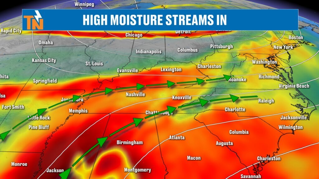
Tropical Moisture From Arthur Moving Into the Southeast
The big weather story today is the tropical moisture plume associated with the remnants of Arthur.
Arthur has weakened into a post-tropical system, but the moisture is still very much intact.
Current setup:
- Center of low pressure just west of Louisiana and southeast Texas
- Heavy rain stretching from the Gulf Coast into New Orleans
- Deep tropical moisture surging northward
- Cold front approaching from the north
This is what I’ve been calling a weather sandwich.
We’ve got:
- Tropical moisture to our south
- A cold front dropping in from the north
- East Tennessee caught in the middle
That combination is going to produce scattered showers, thunderstorms, and locally heavy rainfall today.
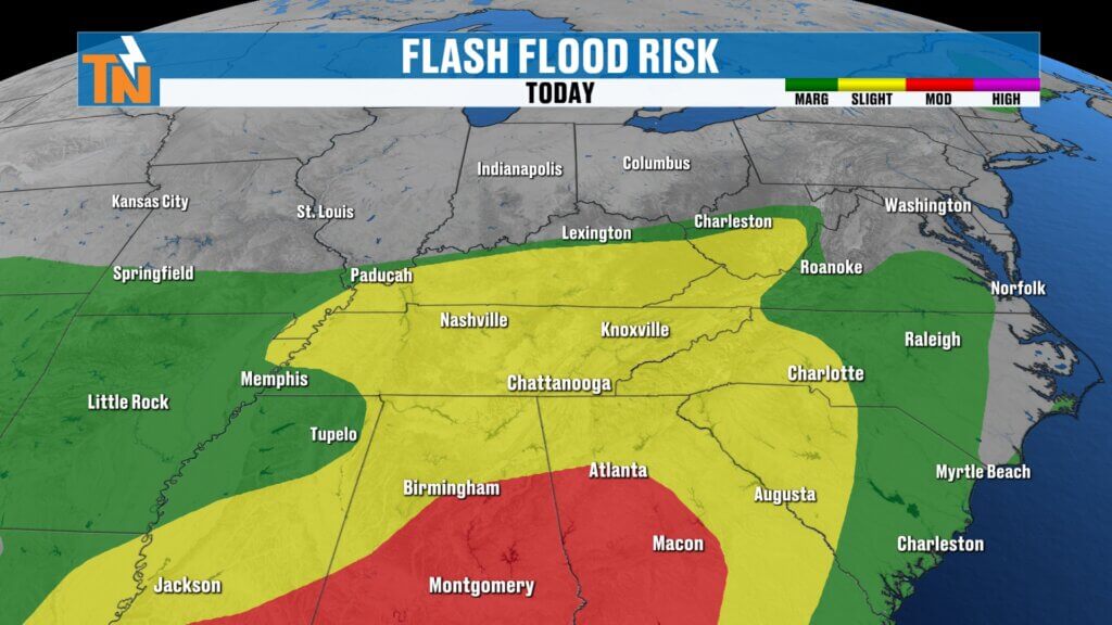
Flooding and Flash Flooding Risk Today
Because of all this moisture, the Weather Prediction Center has placed East Tennessee under a Level 2 risk for flooding and flash flooding.
That means:
- Isolated flash flooding is possible
- Heavy rain rates could quickly overwhelm drainage areas
- Some storms may produce 1 to 2 inches of rain in a short amount of time
This will not be widespread flooding.
But where storms repeatedly develop or slow down, problems can develop quickly.
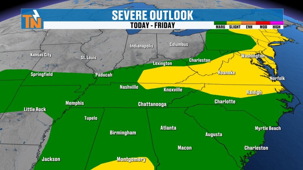
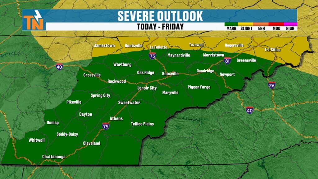
Severe Storm Risk: Mostly Isolated
The Storm Prediction Center also has much of East Tennessee under a Level 1 severe weather risk.
Higher severe weather risk stays north:
- Kentucky
- West Virginia
- Virginia
For us:
Main threat:
- Damaging wind gusts
Secondary threat:
- Heavy rainfall
Lower threats:
- Large hail
- Tornadoes
Any stronger storm that develops today will have plenty of moisture to work with.
That’s why rainfall remains the bigger concern.
Thursday Timing: Spotty Showers and Storms
Today is not an all-day washout.
That’s important.
Futurecast shows:
Morning:
- Mostly cloudy skies
- Spotty showers developing
- Warm and muggy
Afternoon:
- Better chance for scattered storms
- Heavier downpours possible
- Storms may become stronger north of I-40
Evening:
- Additional showers and storms possible
- Heavy rainfall pockets continue
If you’re heading out tonight, especially for events in downtown Maryville or across the valley, keep checking radar.
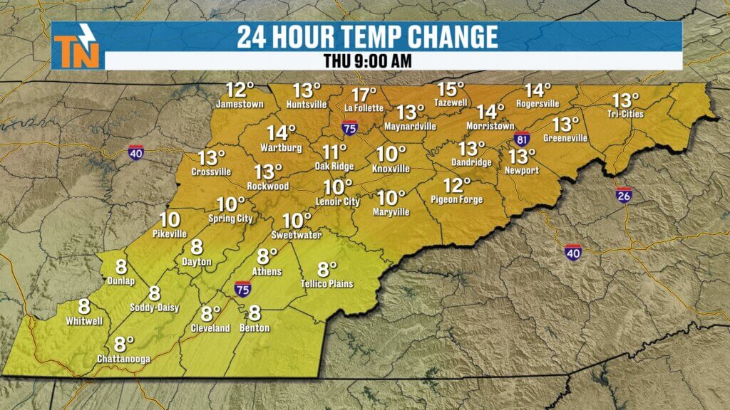
Morning Conditions: It Feels Tropical
This morning feels dramatically different.
Compared to yesterday:
Temperatures are running 10 to 25 degrees warmer.
Current readings:
- 70s to low 80s
- Dew points in the 70s
- Tropical-level humidity
This is the kind of air that hits you the second you step outside.
Heavy.
Sticky.
Thick.
Classic Gulf moisture.
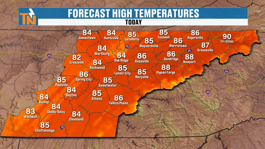
Thursday Afternoon Forecast
Clouds will keep temperatures somewhat in check today.
Forecast highs:
- Low to mid 80s
- Heat index values upper 80s
That’s slightly lower than yesterday’s actual temperatures, but it will feel much warmer because of the humidity.
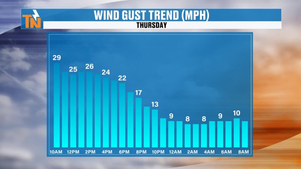
Wind will stay breezy and gusty at times.
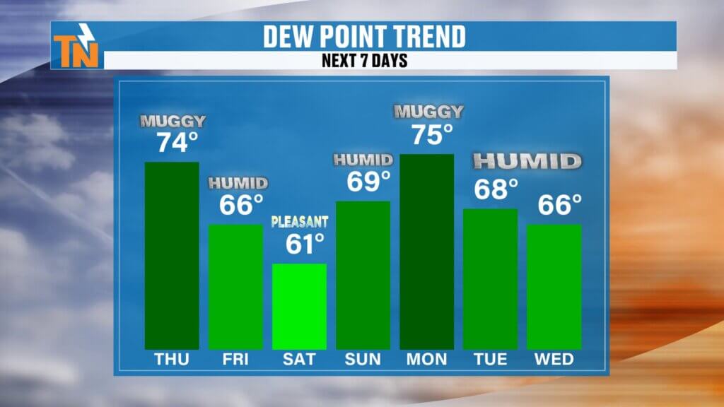
Friday Brings Improvement
Behind today’s cold front:
Humidity drops slightly Friday.
Not a huge drop.
But enough to notice.
Then…
Saturday looks fantastic.
Weekend Forecast: Saturday Wins
Saturday will easily be the best day of the weekend.
Expect:
- Lower humidity
- Sunshine
- Comfortable temperatures
- Dry weather
Sunday changes again.
Humidity increases.
Rain chances increase.
Storms return.

Another Wet Pattern Next Week
Monday looks active.
Current projections show:
- Widespread showers
- Thunderstorms
- Heavy rain
- Another strong cold front
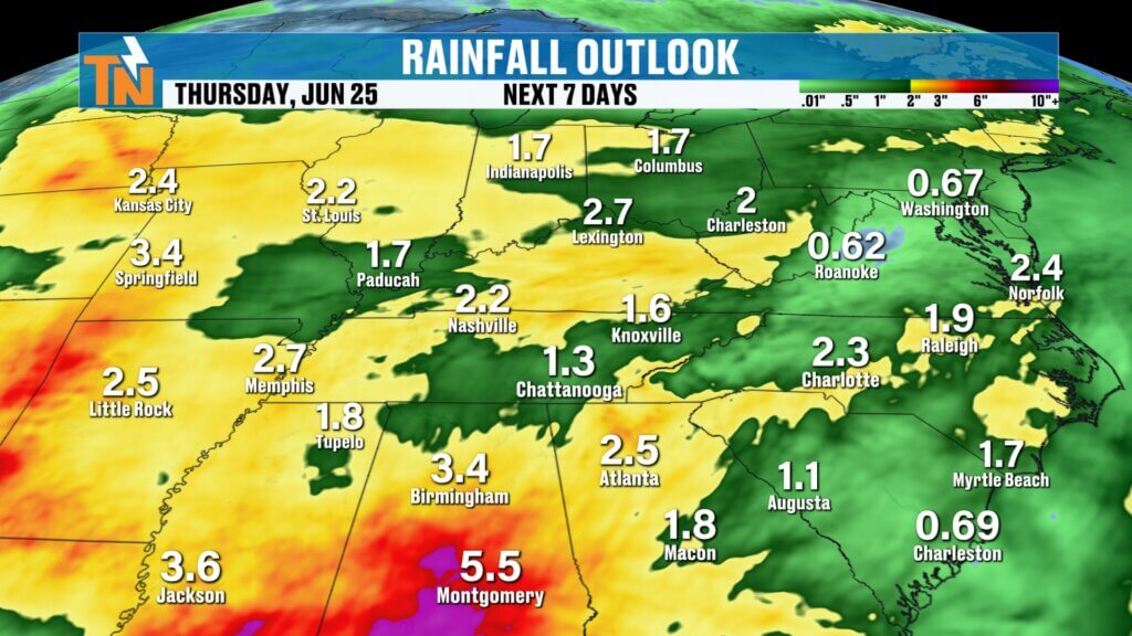
Rainfall totals over the next 7 days:
- 1 to 2 inches areawide
- Isolated higher totals possible
And honestly, some spots could get that today alone.
That’s how tropical this setup is.
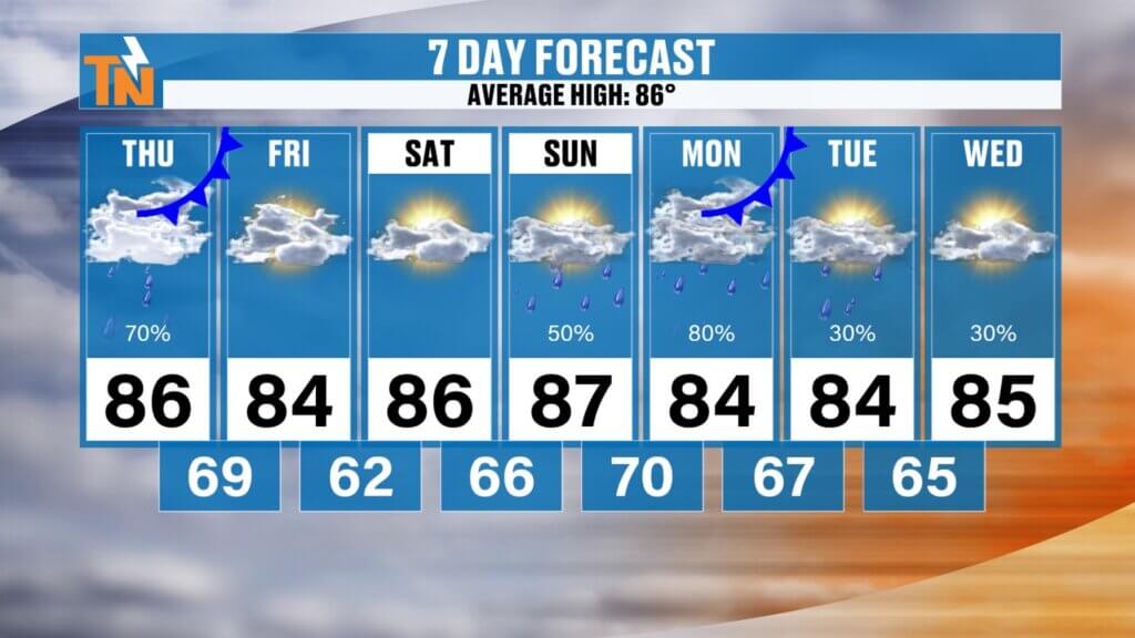
East Tennessee 7-Day Forecast
Thursday
Scattered showers and storms
Heavy rain possible
High: 84°
Friday
Drier and less humid
High: 83°
Saturday
Sunny and pleasant
High: 85°
Sunday
Warmer and more humid
Scattered storms
High: 87°
Monday
Widespread showers and storms
Heavy rain likely
High: 84°
Tuesday
Scattered storms continue
High: 85°
Wednesday
Partly sunny and humid
High: 86°
Bottom Line
Today’s weather story:
- Tropical moisture from Arthur
- Heavy downpours possible
- Localized flooding concerns
- Isolated severe storms
- Damaging wind possible
The big takeaway?
Not everyone gets heavy rain, but if you do, it could be intense.
Saturday still looks like your best outdoor day.
And as always, keep the East Tennessee Weather app handy today.
Interactive radar will be your best friend.
Make sure notifications and location services are turned on so you get weather alerts instantly, especially if you travel or have outdoor plans.
Have a great Thursday, stay weather aware, and I’ll see you back here soon.