
Good morning and happy Wednesday, East Tennessee.
And happy July 1st.
It is officially feeling like July.
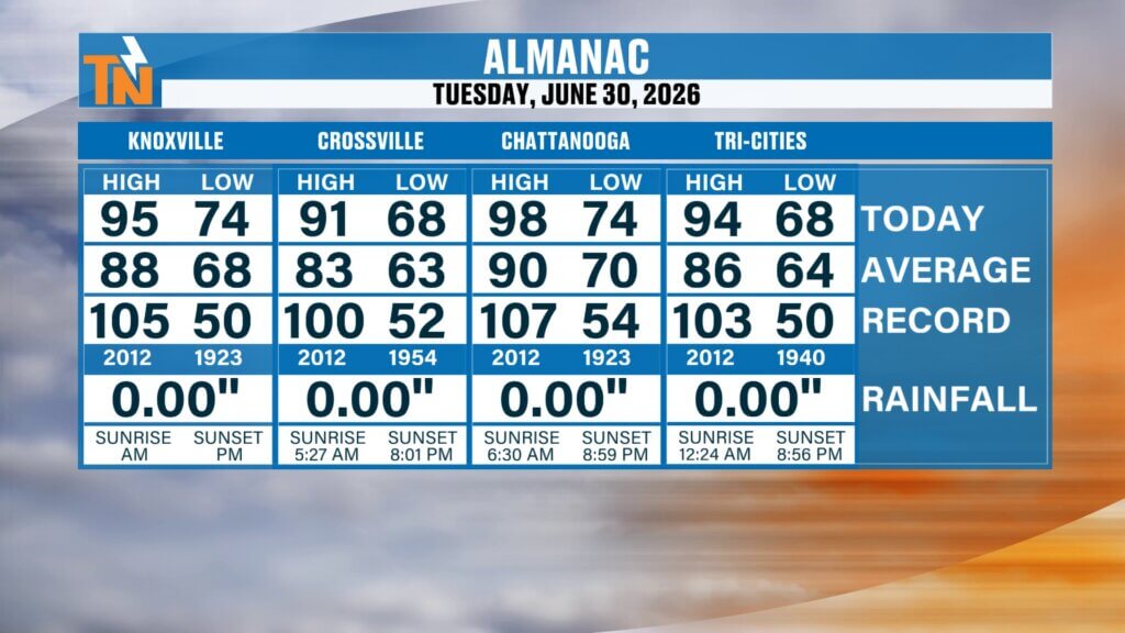
Yesterday we topped out at 95 degrees in Knoxville, and today will be another scorcher.
This dangerous heat continues to build, and with humidity staying extremely high, heat index values will once again push close to 105 degrees.
The National Weather Service has now extended the Heat Advisory through Friday, and honestly, it may not stop there.
This is our first major heat wave of summer.
And it’s serious.
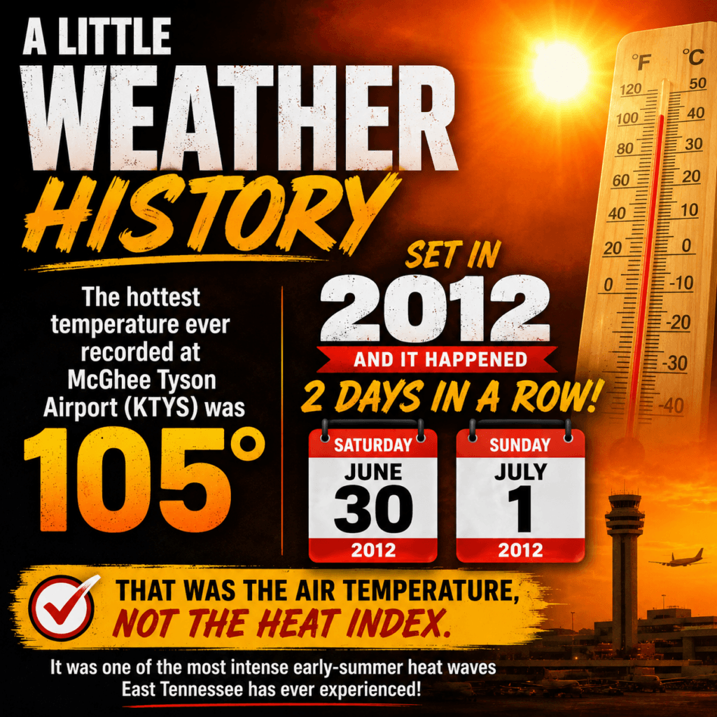
Knoxville Heat History: The All-Time Record Still Stands at 105°
A little weather history for you.
The all-time record high for McGhee Tyson Airport and the Knoxville area is:
105 degrees
Set in 2012
And it happened on July 1st and July 2nd — back-to-back days.
That was actual air temperature.
Not heat index.
Not “feels like.”
Actual air temperature.
We’re nowhere near that today.
But the heat index?
That’s another story.
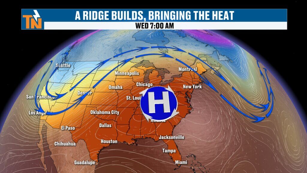
Why It’s So Hot: Ridge of High Pressure Dominating the Southeast
The weather pattern hasn’t changed much.
A strong ridge of high pressure continues to dominate the southeastern United States.
That ridge acts like a heat dome.
It traps hot air.
It limits widespread rain.
And it keeps temperatures climbing.
We’re sitting on the southern edge of that ridge.
That puts us in a southeasterly flow.
And that matters.
Because it allows disturbances to sneak in from the east and southeast.
Those disturbances can trigger isolated storms.
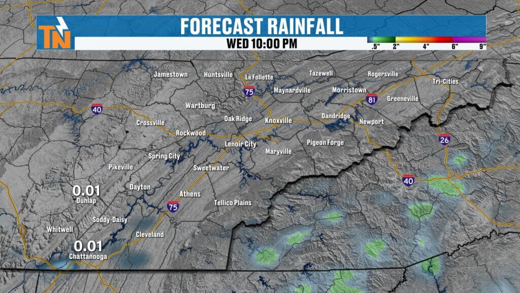
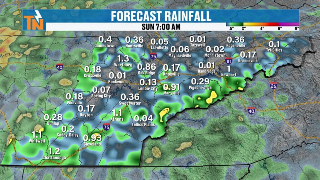
Isolated Storm Chances Today: Best South of Interstate 40
Today’s storm setup is a little different.
The best chance for showers and storms will be:
South of Interstate 40
That includes areas like:
- Chattanooga
- Cleveland
- Athens
- Tellico Plains
Model guidance doesn’t show much.
And yesterday it underperformed too.
But the atmosphere remains extremely unstable.
That means:
If something gets going…
It could pack a punch.
Possible storm threats:
- Strong wind gusts
- Pea-sized hail
- Heavy tropical downpours
- Frequent lightning
Not widespread.
But isolated.
Futurecast Timing: Mostly Dry, Watching Afternoon Development
Morning
Sunny.
Hot.
Very humid.
Afternoon (3 PM – 7 PM)
Watching for isolated pop-up storms.
Most likely south of I-40.
Coverage remains low.
But any storm that develops could intensify quickly.
Evening
Most activity fades after sunset.
But temperatures stay hot.
UV Index Extremely High Today
The UV index will be maxed out.
Peak sunburn time:
10 AM to 4 PM
It won’t take long.
As you said…
“Sunburn City.”
And you’re right.
If you’re headed to:
- The lake
- The pool
- Summer camp
- Ball fields
Use sunscreen.
Stay hydrated.
Find shade.
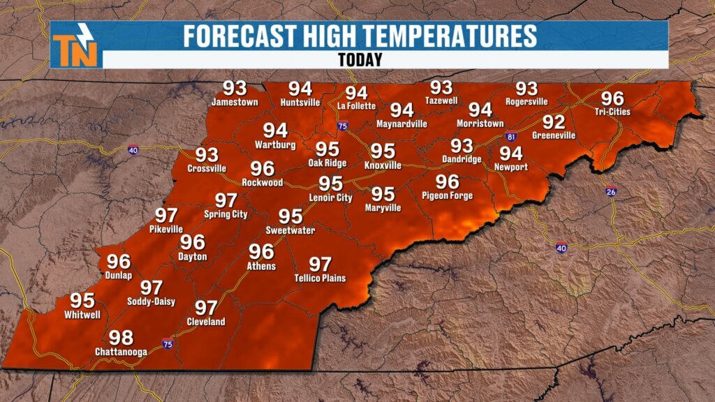
Another Dangerous Heat Day Across East Tennessee
Morning temperatures are already in the 70s.
And they’re warmer than yesterday.
That’s a sign the atmosphere is not cooling.
That’s a problem.
Forecast highs today:
Mid 90s
Average high for July 1st:
88 degrees
That puts us well above normal.
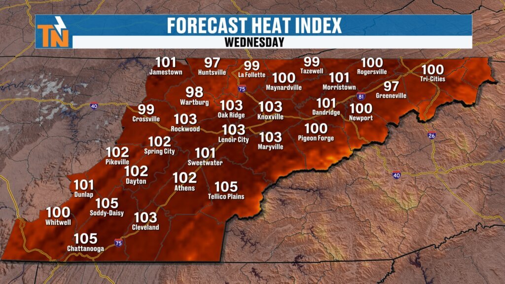
And with dew points staying in the 70s…
Heat index values climb to:
100° to 105°
That’s dangerous.
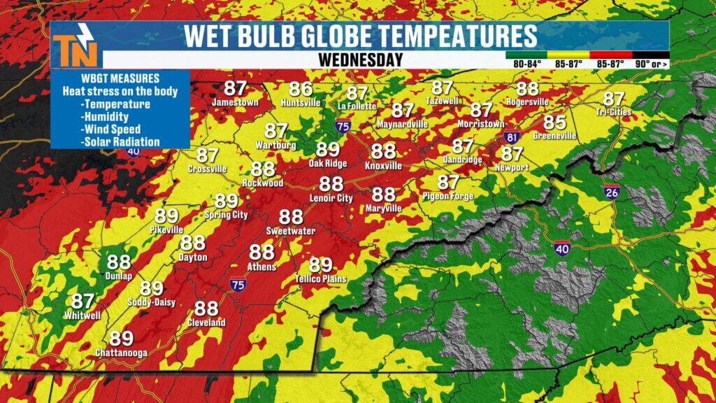
Wet Bulb Globe Temperature Remains High
This matters.
Especially for:
- Outdoor workers
- Athletes
- Coaches
- Parents
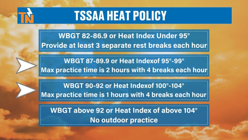
The Tennessee Secondary School Athletic Association uses Wet Bulb Globe Temperature (WBGT).
It factors:
- Temperature
- Humidity
- Wind speed
- Solar radiation
Today:
WBGT values around 88 to 89
That falls in the dangerous category.
Recommended:
- One hour of activity
- Four breaks per hour
That’s not just for sports.
That’s for construction crews.
Landscapers.
Concrete crews.
Anyone working outside.
Heat safety applies to everyone.
More Disturbances Through the Holiday Weekend
This pattern repeats.
Another disturbance Thursday.
Another Friday.
Another Saturday.
And yes…
The Fourth of July forecast includes storm chances.
Not a washout.
But typical summer pop-ups.
Hit and miss.
Fast to develop.
Slow to move.
Heavy rain possible.
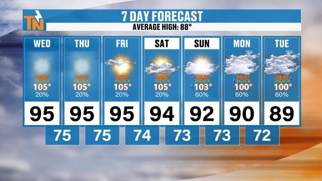
East Tennessee 7-Day Forecast
Wednesday
Hot and humid
Isolated storm south of I-40
High: 95°
Thursday
Dangerous heat continues
High: 95°
Friday
Hot with isolated storms
High: 94°
Saturday (July 4th)
Hot and humid
Scattered afternoon storms
High: 94°
Sunday
Hot with pop-up storms
High: 93°
Monday
Still hot
High: 92°
Tuesday
Slightly cooler
Better storm coverage
High: 89°
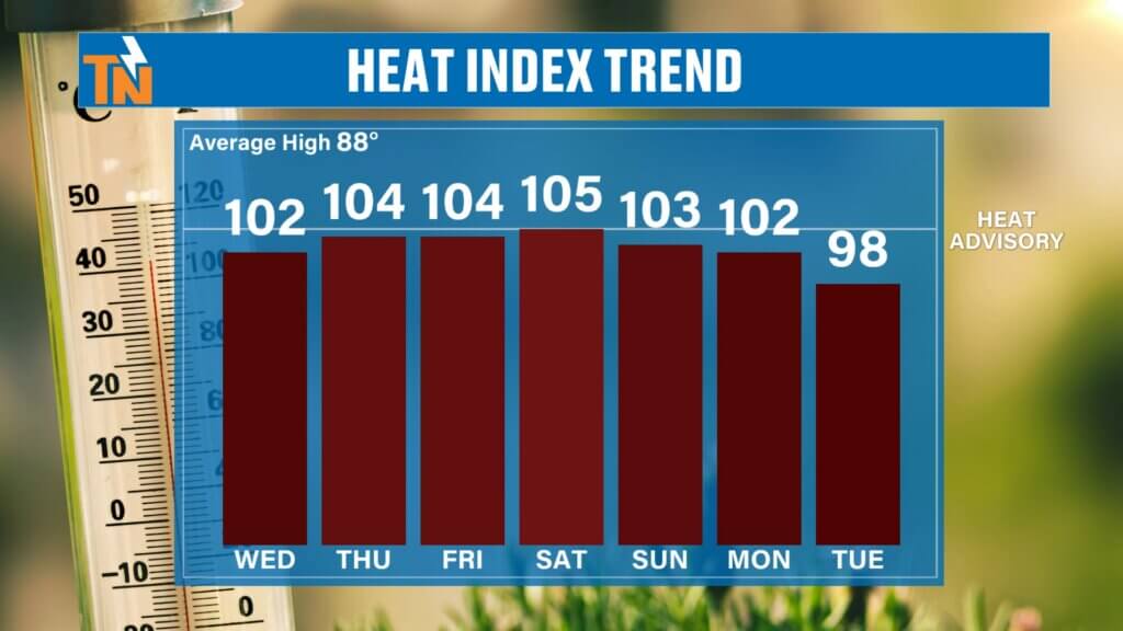
Heat Index Through Saturday
Wednesday: 103°–105°
Thursday: 104°–106°
Friday: 102°–105°
Saturday: 103°–105°
This heat doesn’t back off until early next week.
Bottom Line
The heat remains the story.
Heat Advisory through Friday.
Possibly extended.
Dangerous heat index values.
Isolated afternoon storms.
Best chance south of I-40 today.
Fourth of July still looks hot with scattered pop-up storms.
And this pattern stays with us for several more days.
Take the heat seriously.
Hydrate.
Take breaks.
Wear sunscreen.
And keep checking the East Tennessee Weather for updates.
Have a great Wednesday, and stay cool.