
Good morning and happy Tuesday, East Tennessee.
The heat is building.
And it’s only getting worse.
After topping out at 93 degrees yesterday, we’re going even hotter today, hotter tomorrow, and likely hottest by Thursday.
We are now under a Heat Advisory, and this is the first real dangerous heat stretch of the summer season.
Add in high humidity, tropical moisture, and daily pop-up storms, and it’s a classic East Tennessee summer weather pattern.
Let’s break it all down.
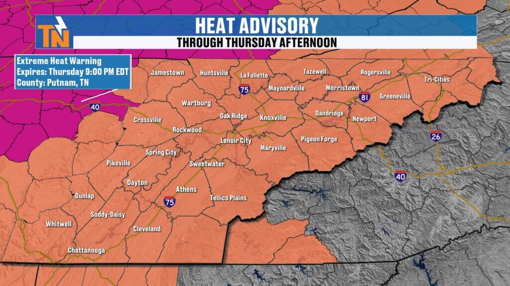
Heat Advisory in Effect for East Tennessee
The big story today is the heat.
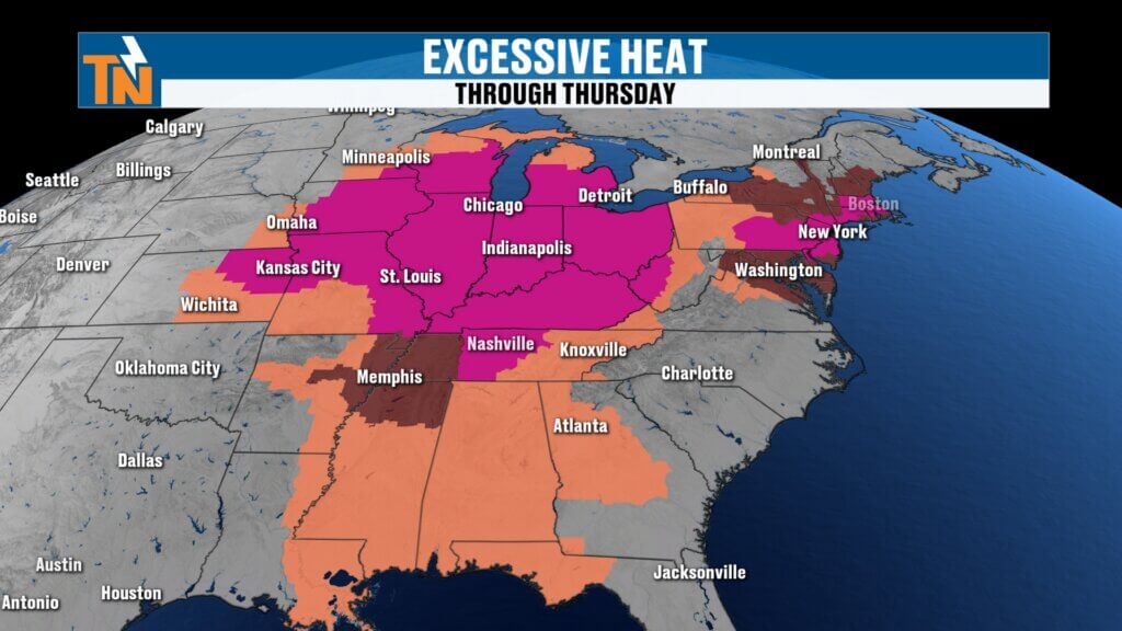
A massive ridge of high pressure is dominating much of the eastern half of the country.
That includes:
- The Great Lakes
- The Northeast
- The Deep South
- And right here in East Tennessee
This ridge acts like a heat dome.
It traps heat.
It suppresses widespread storm activity.
And it allows temperatures to climb day after day.
The National Weather Service has issued a Heat Advisory through Thursday, but there’s already talk it may need to be extended.
And honestly…
That makes sense.
Why It Feels So Oppressive: The Air You Can Wear
The humidity is intense.
Dew points this morning are sitting in the 70s.
That’s tropical-level moisture.
It’s the kind of air you feel immediately when you walk outside.
That thick, sticky, heavy air.
That’s because moisture is still streaming around the edge of this ridge.
And it’s not going anywhere anytime soon.
That means:
- Warmer nights
- Higher heat index values
- More stress on the body
This is not dry heat.
This is oppressive summer heat.
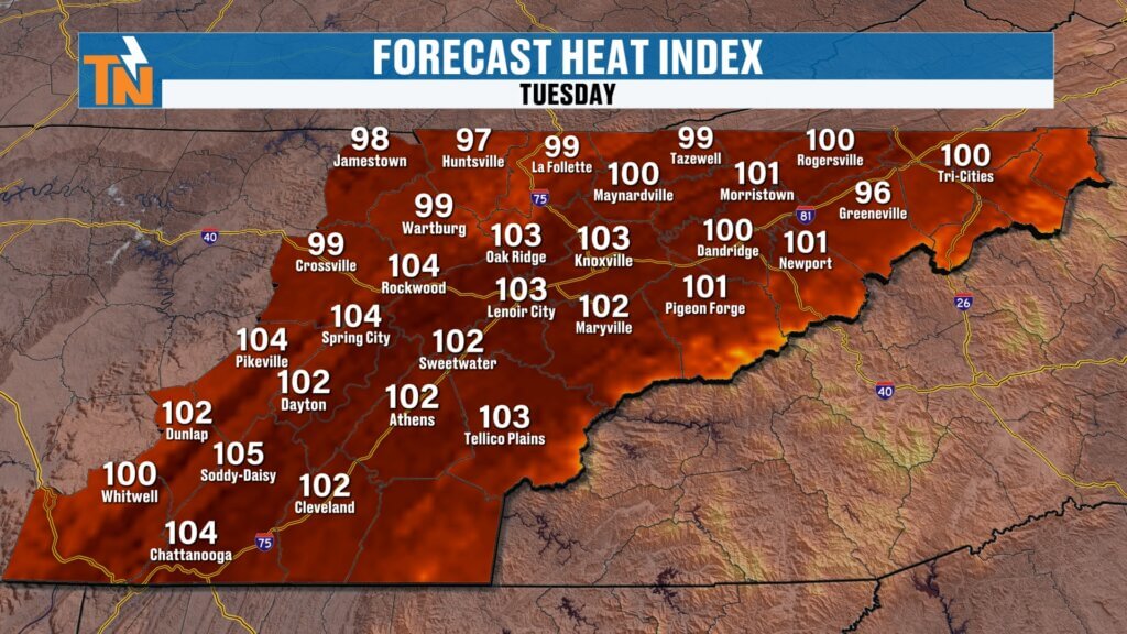
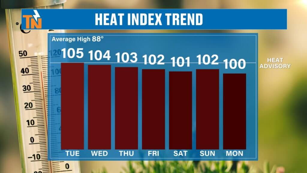
Heat Index Near 105° Today
Actual highs today:
Low to mid 90s
But with humidity factored in:
Heat index values will climb to:
100° to 105°
That’s near dangerous territory.
That’s why the advisory is in place.
And Thursday may be even worse.
Some spots could exceed advisory criteria.
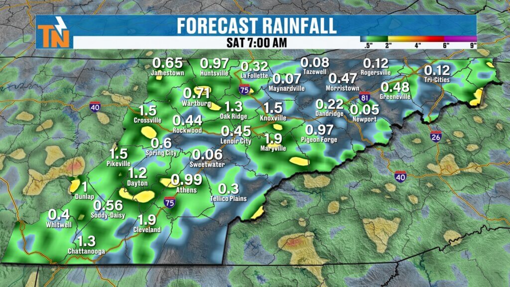
Pop-Up Storms Return This Afternoon
While the heat is the main story, we do have a chance for scattered storms.
Just like yesterday.
A disturbance diving south along the eastern edge of the ridge will help trigger storm development.
That setup brought storms yesterday from:
- Johnson City
- Kingsport
- Greeneville
And that same setup is in play again today.
We’ll also watch:
- Cumberland Plateau
- Higher terrain of the Great Smoky Mountains
Futurecast: Timing Today’s Storms
Morning
Mostly dry.
Hot and muggy.
Some patchy fog.
Noon to 2 PM
Storms begin developing in higher terrain.
Afternoon into Evening (3 PM – 8 PM)
Scattered pop-up storms increase.
Coverage remains isolated.
Not everyone gets rain.
But if you do…
It could be a good one.
Slow Movers = Tropical Downpours
Winds in the atmosphere are light.
That means storms won’t move quickly.
That’s important.
Slow-moving storms can dump a lot of rain in a short amount of time.
We saw that yesterday.
Flood advisories were issued in several spots.
And that remains possible again today.
Any storm could produce:
- Torrential rainfall
- Frequent lightning
- Gusty winds
- Localized flooding
“Heat Lightning” Isn’t Real
A lot of people reported “heat lightning” last night.
Quick reminder:
There’s no such thing as heat lightning.
It’s simply regular lightning from storms too far away for you to hear thunder.
We’ll be talking more about that on social media.
Because weather myths never die.
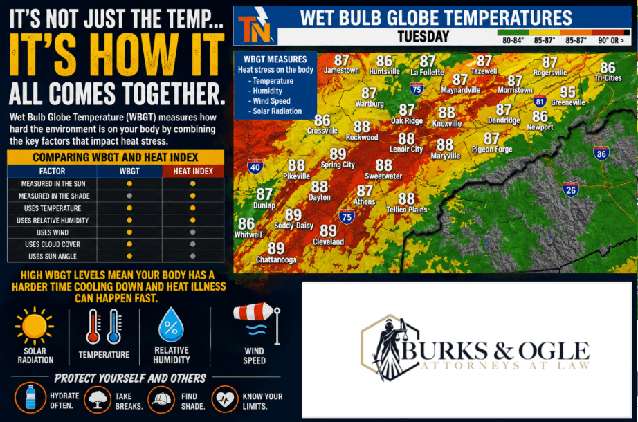
Wet Bulb Globe Temperature: Why Coaches Need to Pay Attention
For athletes, coaches, and parents:
This matters.
The Tennessee Secondary School Athletic Association uses Wet Bulb Globe Temperature (WBGT) for outdoor sports.
WBGT factors:
- Temperature
- Humidity
- Wind speed
- Solar radiation
Today:
WBGT values are in the 80s.
By Thursday:
Some locations could push into the 90s.
That’s dangerous.
Especially in direct sun.
This affects:
- Football practices
- Summer workouts
- Camps
- Outdoor conditioning
Heat safety is critical.
The Heat Doesn’t Go Anywhere This Week
Humidity stays high all week.
Dew points remain in the 70s.
That keeps heat index values elevated every day.
Thursday still looks like the hottest day.
And the most dangerous.
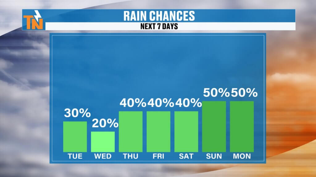
Rain Chances Increase Toward the Holiday Weekend
Daily storm chances continue.
But coverage increases later this week.
Especially heading into the Fourth of July weekend.
That means:
Typical summer pattern.
Heat.
Humidity.
And Mother Nature may bring fireworks of her own.
East Tennessee 7-Day Forecast
Tuesday
Hot and humid
Scattered storms possible
High: 94°
Wednesday
Dangerous heat continues
High: 95°
Thursday
Hottest day of the week
Heat index 105°+
High: 96°
Friday
Hot with scattered storms
High: 94°
Saturday
More afternoon storms
High: 93°
Sunday
Hot and stormy at times
High: 92°
Monday
Summer heat continues
High: 91°
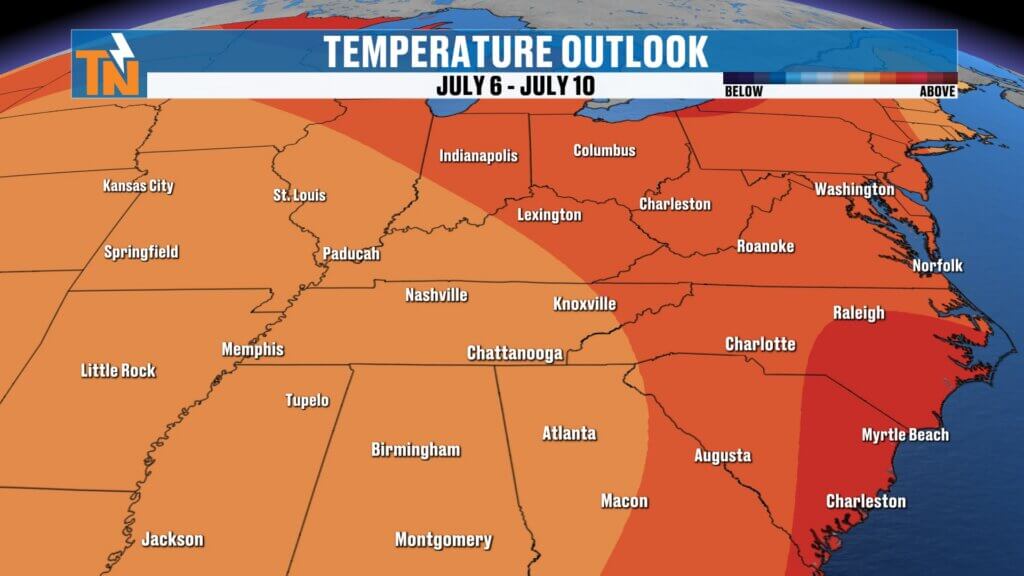
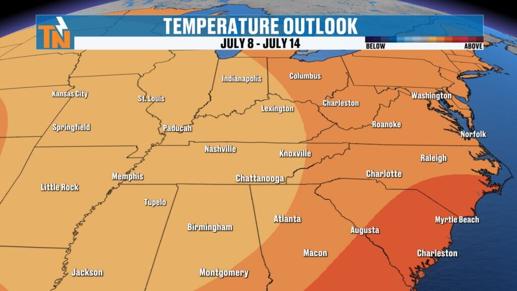
Long Range Outlook
The Climate Prediction Center continues to favor above-average temperatures into the second week of July.
That means this heat likely sticks around.
This isn’t a quick burst.
This is summer settling in.
Bottom Line
Heat is the story.
Dangerous heat.
Oppressive humidity.
Heat index values near 105°.
Scattered pop-up storms this afternoon.
Slow movers.
Heavy rain.
Lots of lightning.
Stay hydrated.
Take extra breaks.
Check on pets.
Check on neighbors.
And if you’re working or playing outside…
Respect the heat.
Track storms and heat alerts anytime with the East Tennessee Weather.
Have a great Tuesday, and stay cool.