
Overview
Good morning and happy Tuesday!
Thanks for checking in with your latest East Tennessee weather update. Another warm and sunny day is ahead, but with it comes elevated fire danger, breezy winds, and only a slight chance for an isolated shower. With dry conditions and ongoing wildfire concerns near House Mountain, it’s important to stay weather-aware and exercise extra caution.
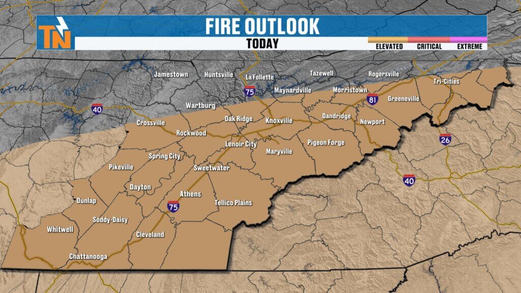

Elevated Fire Danger and House Mountain Fire
Fire weather concerns remain a top story today.
- A wildfire is currently burning near House Mountain, highlighting the dry conditions across the region.
- Dry fuels, low humidity, and breezy winds create an environment where fires can spread quickly.
- The Storm Prediction Center has issued a Level 1 elevated fire risk for much of East Tennessee.
Residents are encouraged to avoid outdoor burning and use caution with any activities that could spark a fire.
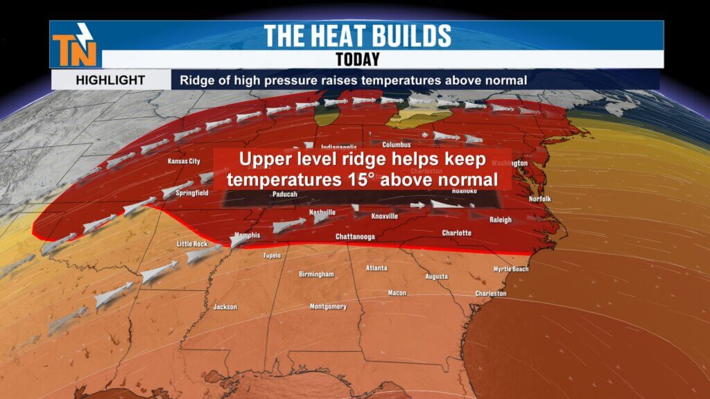

Weather Pattern: High Pressure in Control
A strong ridge of high pressure dominates the weather pattern across the Mid-Atlantic, Great Plains, and Northeast.
- This setup promotes sinking air, leading to sunshine and warming temperatures.
- Temperatures across the Tennessee Valley and Great Lakes are running about 15 degrees above average.
- Most of the moisture and storm activity remains west of the Mississippi River.
This pattern keeps East Tennessee warm and predominantly dry through the remainder of the week.
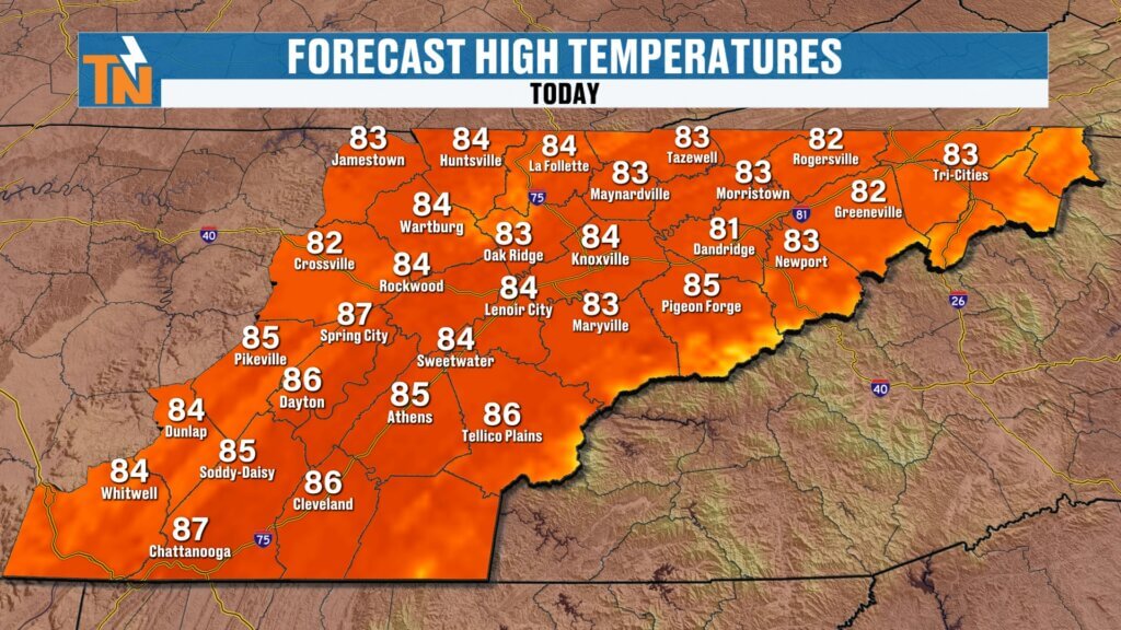
Today’s Forecast
Expect another beautiful but warm day across the region.
- Morning temperatures: Comfortable 50s and 60s.
- Afternoon highs: Low to mid 80s, well above the average high of around 70 degrees.
- Sky conditions: Mostly sunny with a few morning clouds clearing by the afternoon.
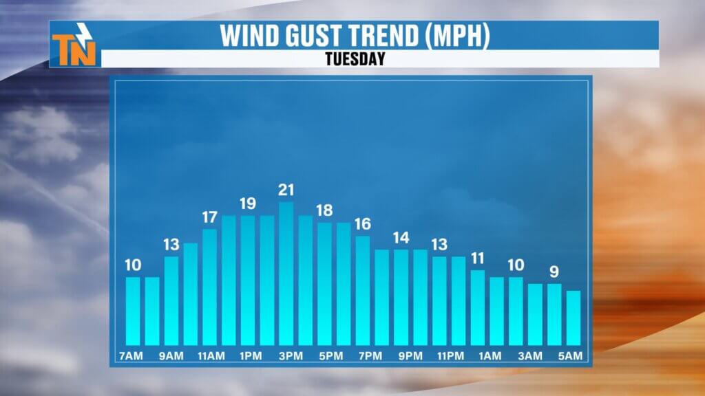
- Winds: Breezy with gusts between 15 and 20 mph.
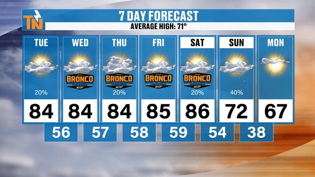
- Rain chances: A slight 20% chance of an isolated stray shower, mainly across the Cumberland Plateau.
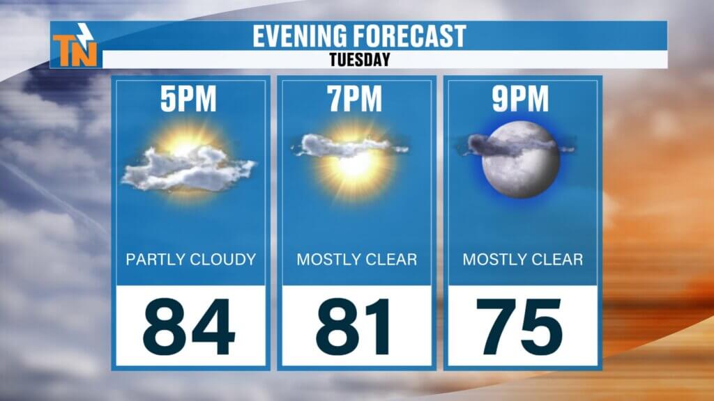
Evening Outlook
Conditions remain pleasant for any evening activities.
Dry and comfortable weather expected for outdoor plans.
Temperatures around 84 degrees by 5 PM.
Cooling slightly to near 81 degrees by 7 PM.
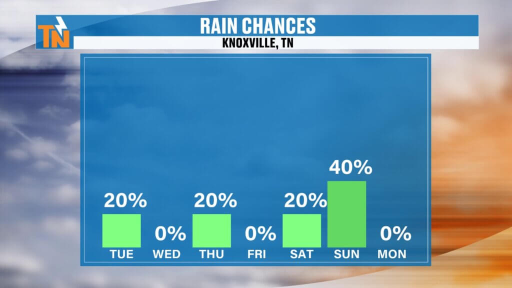
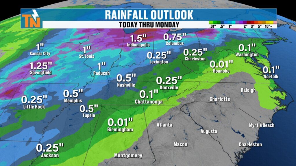
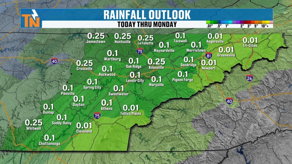
Rain Chances Through the Week
Rainfall will remain limited for most of the week.
The heaviest rainfall across the nation will stay to the west and northwest of East Tennessee.
Minimal rain chances through Saturday.
A cold front arriving Saturday night into Sunday morning will bring the next opportunity for showers.
Expected rainfall totals locally are modest, generally around a quarter of an inch.

Bronco Super Celebration Festival Forecast
The Bronco Super Celebration Festival in Townsend, Tennessee, runs from Wednesday through Saturday, and the weather looks excellent for attendees.
- Wednesday: 86°
- Thursday: 86°
- Friday: 87°
- Saturday: 89°
These temperatures are near record highs, and conditions are expected to remain mostly dry throughout the event.
Extended Outlook: Warm and Mostly Dry
Above-average temperatures are likely to persist beyond the 7-day forecast.
- Continued dominance of high pressure will keep conditions warm and relatively dry.
- Some increase in moisture is possible in the 7–14 day timeframe, offering hope for additional rainfall.
- Until then, drought concerns and elevated fire danger may continue.
Stay Connected
Stay informed with the latest weather updates by downloading the East Tennessee Weather app. Simply search for “East Tennessee Weather” in your app store to access interactive radar, forecasts, and real-time alerts.
Final Thoughts
East Tennessee is set for another stretch of beautiful but very warm weather. While the sunshine is perfect for outdoor activities, elevated fire danger and the ongoing wildfire near House Mountain require extra vigilance. A weak cold front this weekend will bring only limited rainfall but offer a slight break from the heat.
Have a fantastic Tuesday, and thanks for checking in! We’ll see you back here soon.Have a fantastic Monday, and thanks for checking in. We’ll see you back here soon for the next update!