
Published: Monday, September 28, 2026
By Meteorologist Mike Witcher | eastTNweather
Happy Monday, East Tennessee!
What a weekend.
We had about as nice of a fall weekend as you could ask for—cool mornings, comfortable afternoons, low humidity and plenty of sunshine.
And we’ve got one more beautiful fall day ahead of us today.
But our weather pattern is about to change.
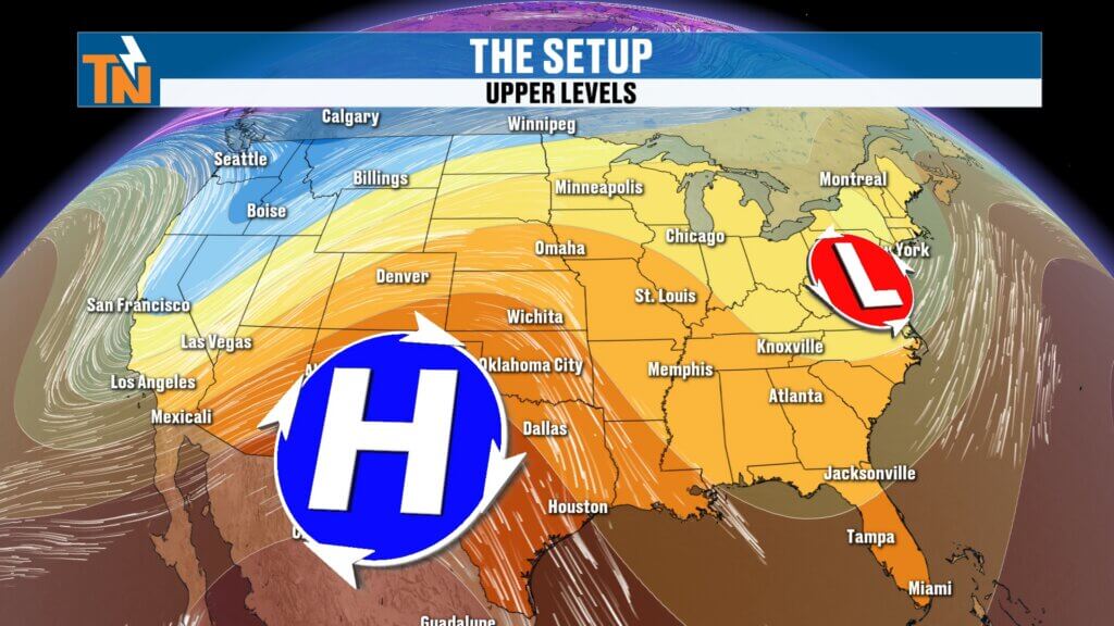
A ridge of high pressure builds into the region this week, bringing temperatures back into the 80s along with increasing humidity. By Thursday and Friday, it’ll feel a little more like late summer again.
Then our attention turns toward the weekend.
A deeper trough, increasing moisture and an approaching weather system could bring our next meaningful opportunity for rain Saturday and Sunday.
And with high school football Friday night, another UT football weekend and plenty of outdoor events going on, this is definitely a forecast you’ll want to keep checking.
Another Beautiful Fall Day
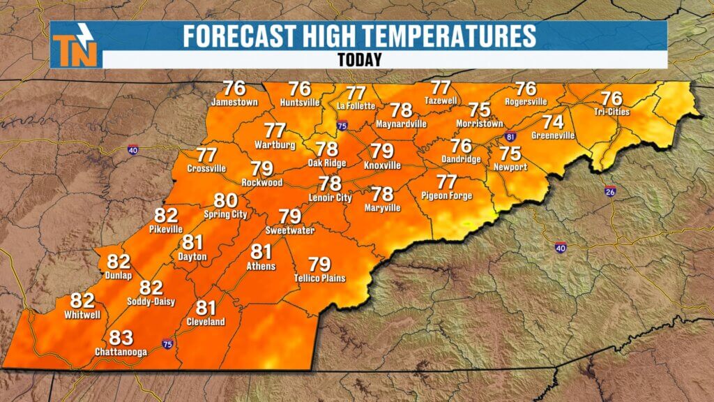
We’re starting Monday with another cool, comfortable morning.
Dew points are down in the 40s and 50s, and that’s allowing temperatures to fall nicely overnight.
You’ll probably want a light jacket or sweatshirt heading out the door this morning, especially for the kids at the bus stop.
But just like this weekend, you won’t need it for long.
Temperatures climb into the upper 70s and lower 80s this afternoon with plenty of sunshine and a light afternoon breeze.
That’s about as close to average as you can get for late September.
Another Great Evening
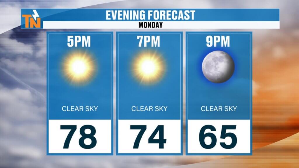
Monday evening looks fantastic as well.
We’ll be around 74° at 7 PM, falling toward 65° by 9 PM.
With the dry air still in place, temperatures will cool quickly after sunset.
So if you’ve got evening plans, you’ll probably want that light jacket again later tonight.
Enjoy it.
Because the humidity is coming back.
Ridge Builds — Temperatures Start Climbing
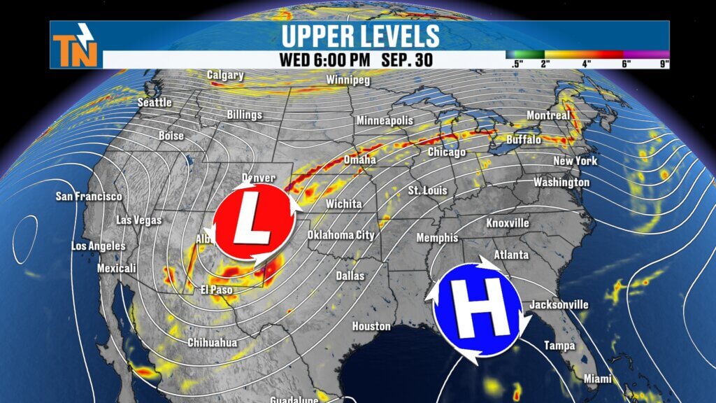
The same overall pattern that gave us our gorgeous weekend begins shifting this week.
A ridge of high pressure gradually strengthens over the southeastern United States.
As that happens, temperatures begin climbing.
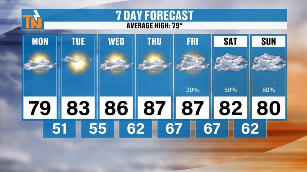
Tuesday should be only slightly above average.
Then Wednesday, Thursday and Friday become noticeably warmer, with afternoon temperatures potentially running close to 10° above average.
That’s going to put us well into the 80s.
Not extreme summer heat—but certainly warm for the end of September and beginning of October.
Humidity Returns Too
It’s not just the temperature.
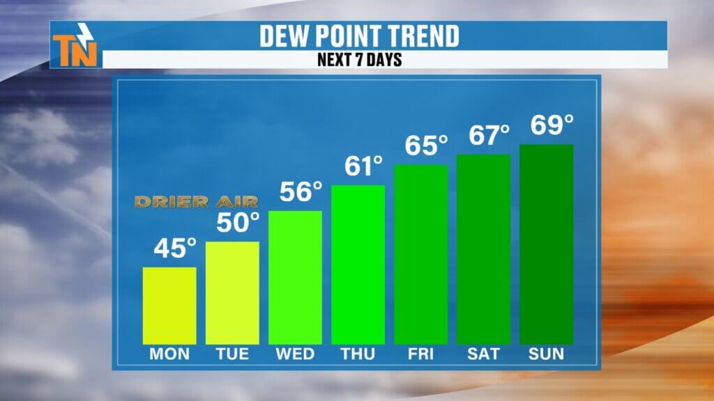
Dew points gradually climb from the 40s and 50s back into the 60s and perhaps close to 70° later this week.
That’s going to make the air feel noticeably different.
By Thursday and Friday, heat index values could approach the lower 90s in some locations.
So after our beautiful fall weekend, we’re getting a brief reminder that summer hasn’t completely disappeared.
The good news for fall lovers?
It doesn’t last very long.
Mostly Dry Through the Work Week
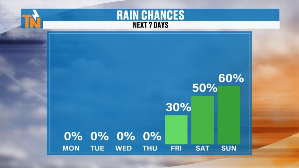
Despite increasing moisture, I think most of the work week stays relatively dry.
High pressure across the Southeast should be strong enough to hold our next larger system west of East Tennessee for a while.
There are some indications that a small disturbance could approach from the south Friday, so I’ve introduced about a 30% rain chance.
But right now, I’m not expecting widespread rainfall through Friday.
The bigger changes appear to arrive over the weekend.
Weekend Rain Chances Are Going UP
This is going to be the forecast to watch this week.
A deeper trough begins digging into the United States while considerably more moisture becomes available across our region.
That should increase our rain chances to around 50–60% Saturday and Sunday based on the current forecast.
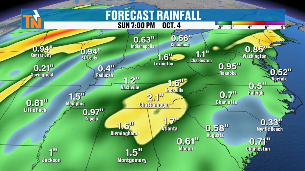
Some of the model guidance is also producing pockets of heavier rainfall.
Here’s where I want to be careful:
Don’t concentrate on specific rainfall totals yet.
If one model puts 3 inches over Knoxville this far out, that does NOT mean Knoxville is getting 3 inches of rain.
What matters right now is the overall signal.
And the signal says:
Our atmosphere gets wetter and our opportunity for meaningful rainfall increases this weekend.
That’s something I’ll be tracking all week.
A Big Weekend for Outdoor Plans
The timing matters because we’ve got plenty happening around East Tennessee.
We’ve got high school football Friday night, another UT football weekend and numerous fall events taking place across the region.
Right now, I’m not telling anybody to cancel plans.
We’re way too early for that.
Instead:
Keep your plans and keep checking the forecast.
Over the next several days, we’ll begin narrowing down when the best rain coverage develops, whether we get breaks between rounds and whether Saturday or Sunday becomes the wetter day.
That’s where the details will really start to matter.
Why Is the Pattern Becoming Wetter?
The larger weather pattern across the country is becoming more active.
A western trough is helping pull tropical moisture northward out of the eastern Pacific and Mexico into portions of the Southwest and Great Plains.
Meanwhile, another trough eventually approaches from the west.
Here in East Tennessee, our ridge initially keeps us warm and mainly dry.
But as the pattern evolves, moisture begins increasing ahead of the approaching trough.
That combination could eventually give us a much better environment for showers and potentially some thunderstormsnext weekend.
We’re still several days away, so expect changes.
Model guidance is guidance, not gospel.
The Fall Roller Coaster Is Here
This is the time of year when East Tennessee weather starts doing this:
Cool down → Warm up → Cool down → Warm up.
Every four or five days, another weather system can knock temperatures down before another ridge builds them back up.
But the overall seasonal trend is still downward.
We’re losing daylight.
Average temperatures continue dropping.
And each cold front has a better opportunity to deliver cooler air than the one before it.
That’s fall in East Tennessee.
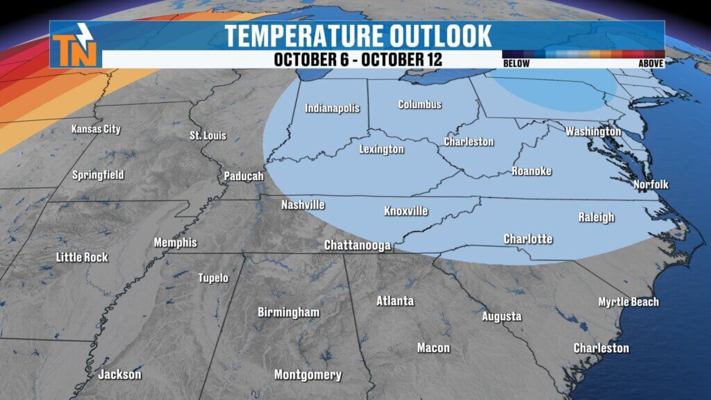
Could It Turn Cooler Again Next Week?
Potentially.
After our weekend system moves through, temperatures may return closer to seasonal averages early next week.
Longer-range outlooks are also showing some potential for cooler air developing beyond the seven-day forecast.
How cool?
That’s still up for debate.
But after our brief late-summer warmup this week, there are signs that another fall-like change could follow.
I’ll keep you posted.
Bottom Line
MONDAY: Beautiful! Sunny, dry and comfortable. Upper 70s to lower 80s.
TUESDAY: Mostly sunny and slightly warmer.
WEDNESDAY: Warming up with increasing humidity.
THURSDAY: Much warmer and more humid. Heat index values begin climbing.
FRIDAY: Warm and humid with a small chance for a shower. Watching Friday night football closely.
SATURDAY–SUNDAY: Our next better opportunity for showers and potentially some thunderstorms. Don’t cancel outdoor plans—just keep checking back as we narrow down the timing.
EARLY NEXT WEEK: Potentially trending cooler and more seasonable again.
So enjoy another beautiful fall day today.
Then we warm it up.
We add the humidity.
And by the weekend, we may finally bring some meaningful rain back into East Tennessee.
Make sure you download the FREE eastTNweather app from your app store. You’ll find your current conditions, local seven-day forecast, QuickCast updates and interactive radar showing past, current and future radar out to two hours.
And if you’re watching on YouTube, don’t forget to LIKE, SHARE, SUBSCRIBE and hit the bell so you’re notified as I fine-tune that weekend rain forecast throughout the week.
I’m Meteorologist Mike Witcher.
Have a fantastic Monday!
eastTNweather — Weather When You Want It.
East Tennessee weather, Knoxville weather, Knoxville forecast, East Tennessee forecast, Knoxville weekend weather, East Tennessee weekend forecast, East Tennessee rain, Knoxville rain this weekend, Tennessee weekend rain, East Tennessee thunderstorms, Knoxville thunderstorms, Tennessee fall weather, Knoxville fall weather, East Tennessee October weather, October weather Tennessee, East Tennessee heat, Knoxville temperatures, Tennessee football weather, UT football weather, Knoxville football forecast, high school football weather, Smoky Mountains weather, Chattanooga weather, Tri Cities weather, Mike Witcher, eastTNweather
#eastTNweather #TNwx #KnoxvilleWeather #EastTennessee #WeekendWeather #RainChances #FallWeather #TennesseeWeather #Knoxville #Chattanooga #TriCities #SmokyMountains #UTFootball #FootballWeather #OctoberWeather #WeatherForecast #MikeWitcher