
Published: Sunday, September 20, 2026
By Meteorologist Mike Witcher | eastTNweather
Good morning and Happy Sunday!
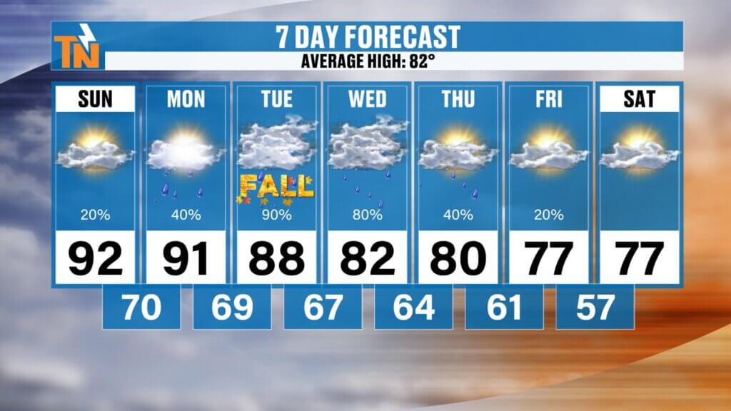
Fall lovers, I finally have some good news for you.
We have to survive a couple more very hot days and several rounds of thunderstorms, but the never-ending summer of 2026 is finally about to take a hit.
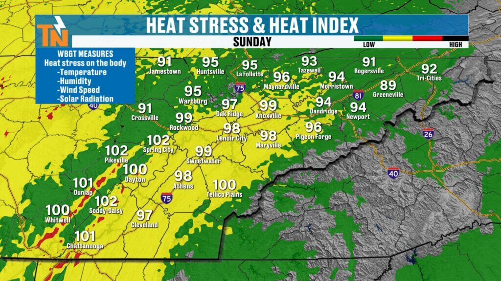
We’re back into the 90s today with heat index values approaching 100° in spots. A few thunderstorms will also develop later today, but the better opportunity for storms—and some stronger storms—arrives Monday.
Then Tuesday and Wednesday bring our best opportunities for more widespread, beneficial rainfall.
Behind all of it?
Cooler and drier Canadian air finally settles into East Tennessee.
By the first full weekend of fall, we’re talking highs in the upper 70s.
Yes. I said 70s!
One More Hot Sunday
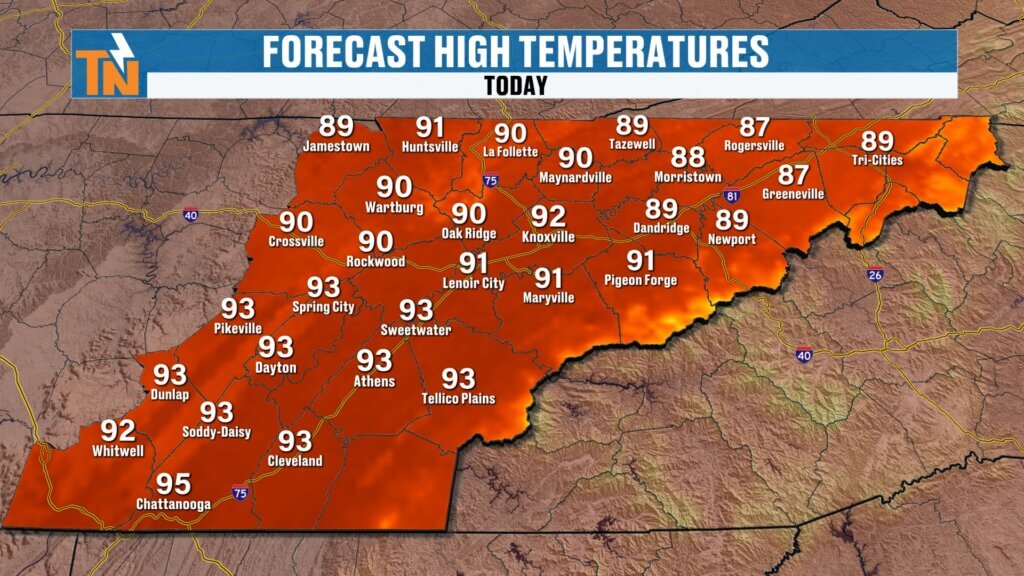
Knoxville reached 92° Saturday, and portions of the Southern Valley climbed into the upper 90s.
We’re going right back into the heat today.
Highs should reach the lower to middle 90s, with a few hotter pockets possible across the Southern Valley.
Heat index values will once again reach the middle and upper 90s to lower 100s.
Heat Advisories remain in effect west and northwest of East Tennessee across portions of Middle Tennessee, Kentucky, southern Illinois and Missouri, but East Tennessee is currently outside those advisories.
That doesn’t mean it won’t be hot.
It absolutely will be.
Most of Sunday Stays Dry
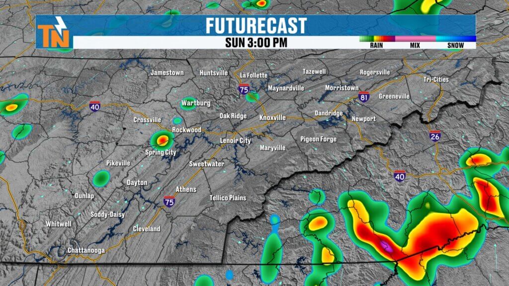
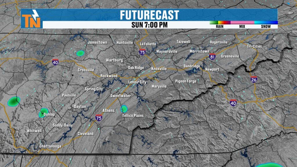
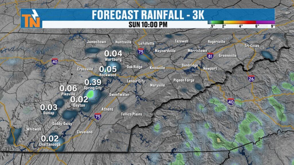
Here’s the good news if you’ve got outdoor plans today:
Most of the day should be just fine.
We’re underneath what meteorologists often call the “ring of fire,” with disturbances traveling around the outer edge of our weakening ridge of high pressure.
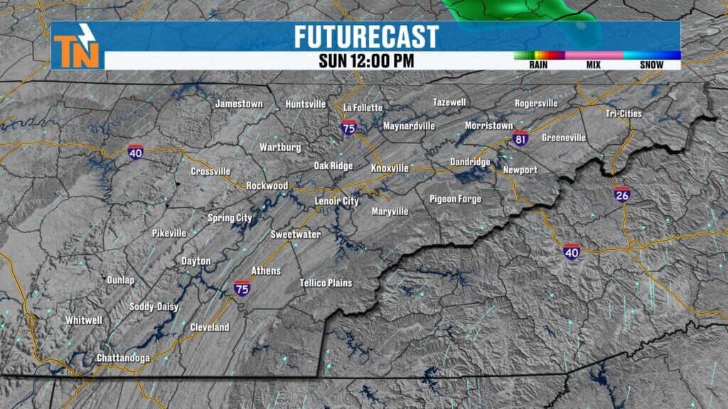
We’ll stay mainly dry through lunchtime and into the early afternoon.
A few spotty showers could begin developing after about 3 PM, but I think our somewhat better opportunity comes after roughly 4–6 PM, as activity approaches from the west and northwest.
Not everyone gets rain today.
We’re carrying only about a 20% chance, so this is very much a hit-or-miss setup.
Could We See a Strong Storm Today?
The Storm Prediction Center has shifted its organized severe-weather risk farther north, leaving East Tennessee outside the highlighted risk area today.
However, that doesn’t mean a stronger storm is impossible.
With plenty of heat and instability available, a collapsing thunderstorm could produce a burst of strong, gusty wind.
An isolated severe storm can’t completely be ruled out, but I’m not expecting an organized severe-weather event today.
Keep your plans.
Just keep radar nearby later this afternoon and evening.
Monday: Severe Weather Risk Increases
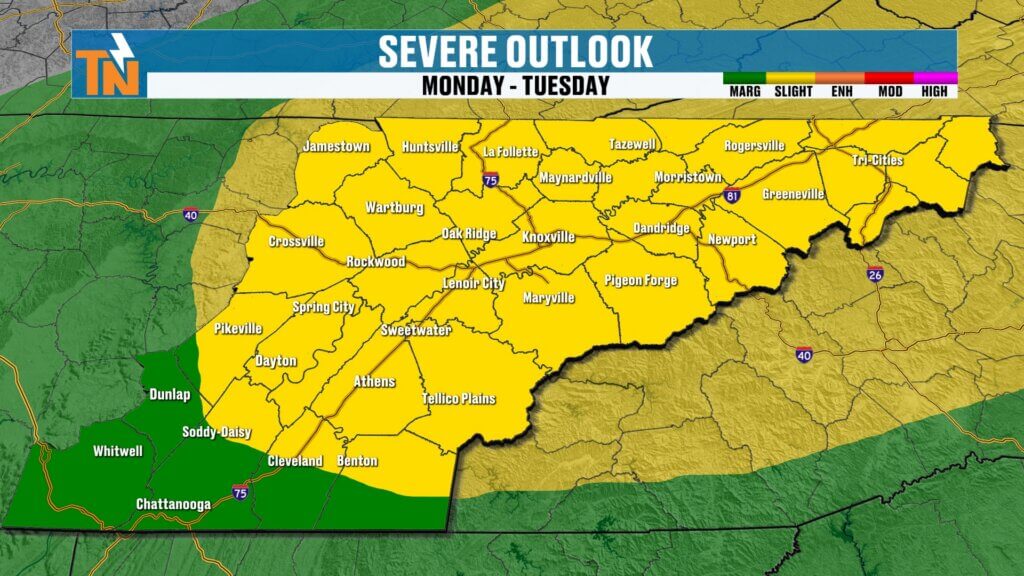
Monday is a different story.
The Storm Prediction Center has highlighted much of East Tennessee with a Level 2 risk for severe thunderstorms, surrounded by a Level 1 risk.
We’re going to have more instability, an approaching frontal boundary and additional upper-level energy moving through the region.
That combination should produce better thunderstorm coverage.
Timing currently favors the afternoon and early evening.
Storms should begin increasing around 3 PM, with additional development through the evening commute and toward 7 PM.
After about 7 PM, activity should gradually begin winding down.
The primary concern with any stronger storm will be damaging wind gusts.
So Monday is definitely a day to stay weather aware, especially during the afternoon school pickup and evening commute.
The Heat Isn’t Gone Monday
Don’t expect Monday’s storms to immediately end our summer heat.
We’re still looking at temperatures around 91°, with heat index values climbing into the middle and upper 90s and perhaps lower 100s.
That heat and humidity will actually help provide some of the instability needed for afternoon thunderstorms.
After Monday, however, the changes really begin.
Tuesday & Wednesday Bring Our Best Rain Chances
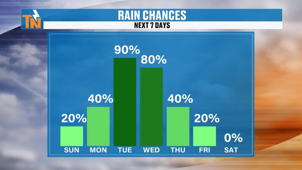
A cold front and several upper-level disturbances move through East Tennessee during the first half of the week.
That should give us our best opportunity for meaningful rainfall in quite some time.
Tuesday brings another strong chance for showers and thunderstorms, with the better coverage gradually shifting into the eastern half of East Tennessee as the front moves through.
Then Wednesday may feature additional showers and storms as an upper-level low develops around the region.
Storm movement could also change Wednesday, with activity moving more south to north or northwest.
I’m carrying rain chances near 100% Tuesday and Wednesday, but remember what that means.
It doesn’t mean it rains at your house for two straight days.
It means we’re expecting widespread enough coverage that most of East Tennessee has a very good opportunity to receive measurable rainfall during that period.
And some of you desperately need it.
Beneficial Rain for Our Expanding Drought
I’ve heard from plenty of you lately:
“Mike, storms are everywhere around me, but I can’t get a drop!”
Hopefully this week’s pattern finally helps.
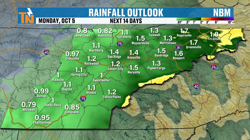
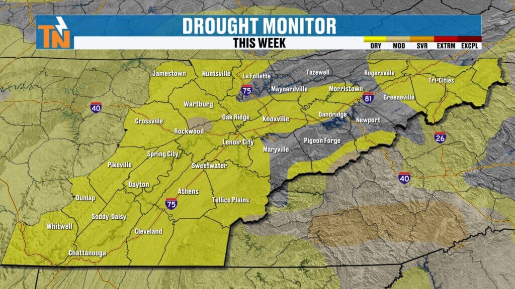
Abnormally dry conditions have expanded across East Tennessee, with more significant drought conditions developing around portions of the Smokies and western North Carolina.
This week’s rainfall could provide some much-needed help.
Some locations could potentially pick up around 1–2 inches over the broader period, although amounts will vary significantly depending on exactly where thunderstorms track.
And looking beyond this week, the pattern appears considerably drier.
So let’s take whatever beneficial rain we can get.
Fall Officially Arrives Tuesday
There’s something fitting about the timing.
Astronomical fall begins Tuesday, right as our weather pattern starts transitioning.
Don’t expect instant sweater weather Tuesday afternoon.
We’ll still reach around 88°, well above our average high of roughly 82°.
But the front begins opening the door for a much different air mass.
And by Wednesday and Thursday?
You’ll start noticing it.
Canadian Air Is Coming!
Behind the front, high pressure begins funneling cooler and much drier air out of Canada toward East Tennessee.
Dew points drop.
Humidity drops.
Heat index values disappear.
And temperatures finally begin coming down.
After highs around:
Sunday: 92°
Monday: 91°
Tuesday: 88°
We should fall closer to seasonal averages Wednesday and Thursday.
Then comes the really good stuff.
First Full Weekend of Fall: UPPER 70s!
If current trends hold, the first full weekend of fall could actually feel like fall.
High temperatures Friday into the weekend are expected to drop into the upper 70s to around 80°.
After weeks of temperatures running well above average, that’s going to feel fantastic.
And with lower dew points, we’re not just talking about cooler thermometer readings.
We’re talking about that cool, fresh fall feeling so many of you have been waiting for.
The air you can finally enjoy is coming back!
One Last Great Lake Day
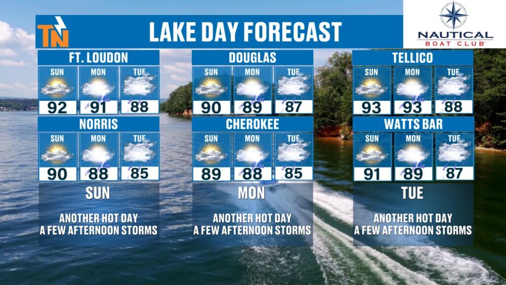
Before the storms and cooler air arrive, Sunday remains a good opportunity to enjoy some lake time.
Norris Lake, Fort Loudoun, Tellico, Douglas, Cherokee and Watts Bar should all offer plenty of usable weather today.
Just remember that a few thunderstorms could develop later this afternoon and evening.
So enjoy the water, but keep the eastTNweather app handy for radar and lightning information.
Bottom Line
SUNDAY: Hot again with highs in the lower 90s. Most of the day stays dry, followed by a few late-afternoon and evening thunderstorms. An isolated strong storm can’t be ruled out.
MONDAY: Hot and humid with thunderstorms increasing during the afternoon and early evening. Much of East Tennessee is under a Level 2 severe-weather risk, with damaging wind the primary concern.
TUESDAY: Fall officially begins! Showers and thunderstorms become more widespread as our cold front moves through.
WEDNESDAY: Additional showers and storms possible with temperatures finally coming down.
THURSDAY: Rain chances decrease and cooler, drier air takes over.
FRIDAY–WEEKEND: Here it is, fall lovers! Highs potentially in the upper 70s with much lower humidity.
So yes…
The never-ending summer of 2026 has a few more punches to throw.
But this time, there really is fall weather on the seven-day forecast.
Make sure you download the FREE eastTNweather app, turn on location services and notifications, and keep it handy Monday through Wednesday as thunderstorms move through the region.
And if you’re watching on YouTube, don’t forget to LIKE, SHARE and SUBSCRIBE and hit the bell so you’re notified whenever I post an update—especially with the severe-weather potential Monday.
I’m Meteorologist Mike Witcher.
Have a great Sunday!
eastTNweather — Weather When You Want It.
East Tennessee weather, Knoxville weather, East Tennessee severe weather, Knoxville severe weather Monday, Tennessee severe storms, East Tennessee storms Monday, SPC Level 2 East Tennessee, Knoxville thunderstorms, Tennessee cold front, East Tennessee cold front, East Tennessee fall weather, Knoxville fall weather, first day of fall 2026, Tennessee fall temperatures, East Tennessee cooler weather, Knoxville cooler weather, East Tennessee rain forecast, Tennessee drought, Smoky Mountains drought, East Tennessee weekend forecast, Mike Witcher, eastTNweather
#eastTNweather #TNwx #KnoxvilleWeather #EastTennessee #SevereWeather #StrongStorms #DamagingWinds #ColdFront #FallWeather #FirstDayOfFall #FinallyFall #Knoxville #Chattanooga #TriCities #SmokyMountains #TennesseeWeather #WeekendWeather #MikeWitcher