
Good morning and happy Monday!
After a weekend filled with flooding and flash flooding across parts of East Tennessee, we’re not quite finished with this active weather pattern just yet.
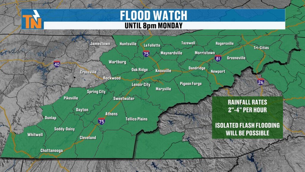
The National Weather Service has extended the Flood Watch through 8:00 PM this evening as another round of showers and thunderstorms moves through the region. While today’s rainfall may not be as widespread as what we’ve experienced over the past several days, any storm that develops will be capable of producing very heavy rainfall over already saturated ground.
Weekend Rainfall Sets the Stage
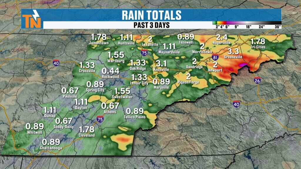
Over the last 24 hours, some communities picked up significant rainfall, especially across portions of East Tennessee that were repeatedly impacted by thunderstorms.
Looking back over the past three days tells an even bigger story.
Areas across Greene, Cocke, Unicoi, Polk, and portions of Knox County have received multiple rounds of heavy rainfall, leading to numerous Flash Flood Warnings and high water issues throughout the weekend.
At the same time, other communities received very little rainfall. It has been a classic summer pattern of localized heavy downpours, with some neighborhoods seeing several inches of rain while others barely picked up enough to settle the dust.
Flood Threat Continues Today
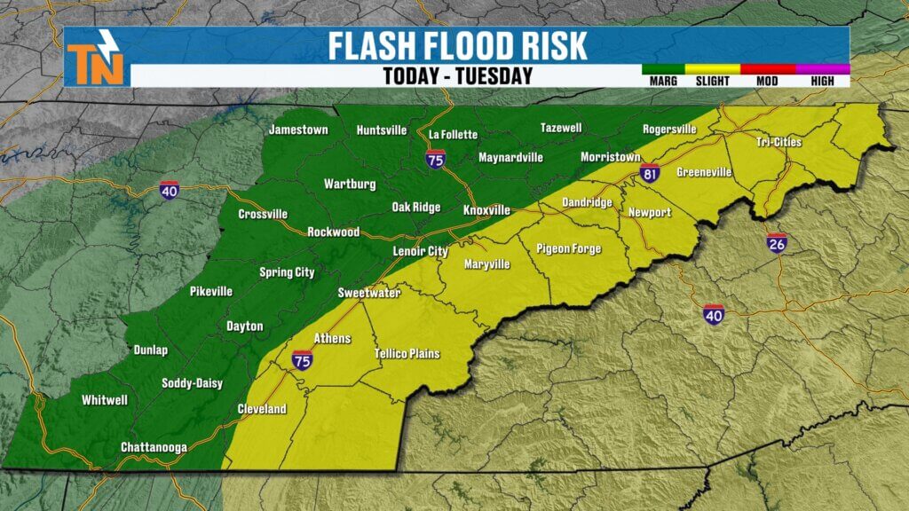
Because of the saturated ground and the potential for additional heavy rainfall, the Weather Prediction Center continues to highlight East Tennessee for excessive rainfall.
- Level 2 flood risk across portions of the mountain counties
- Level 1 flood risk elsewhere across the region
Any additional storms moving across areas that flooded this weekend could quickly lead to renewed flooding and flash flooding concerns.
Rainfall rates of 1 to 3 inches per hour remain possible underneath the strongest thunderstorms.
Monday Forecast
An upper-level low continues spinning across the region today, keeping scattered showers and thunderstorms in the forecast.
One noticeable change from the weekend is storm motion.
Instead of moving from the west or northwest, today’s showers and thunderstorms will wrap around the circulation and move from the north and northeast, focusing additional rainfall across the foothills and mountain counties.
Expect periods of scattered showers and thunderstorms through much of the day.
This will not be a steady all-day rain, but rather several rounds of showers separated by quieter periods.
Most of the activity should gradually diminish this evening, with rain tapering off around sunset and continuing to decrease overnight.
Stay Focused on the Big Picture
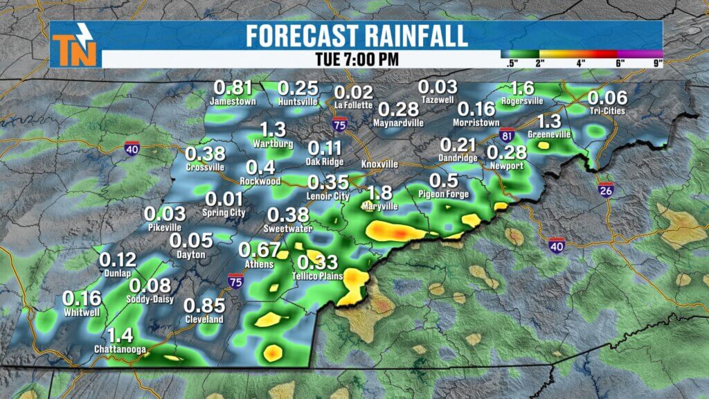
Forecast models continue to highlight pockets of heavier rainfall across East Tennessee.
As always, don’t focus on the exact rainfall totals shown over your neighborhood.
The guidance is simply identifying areas where repeated storms could produce heavy rain—not guaranteeing those exact totals for every location.
If Flash Flood Warnings are issued for your area today, move to higher ground immediately. Flooding can develop very quickly when storms repeatedly move over saturated ground.
Temperatures
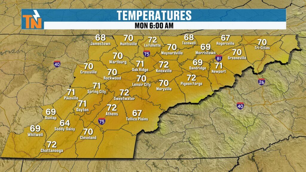
Morning temperatures begin in the 60s and 70s under cloudy, humid conditions.
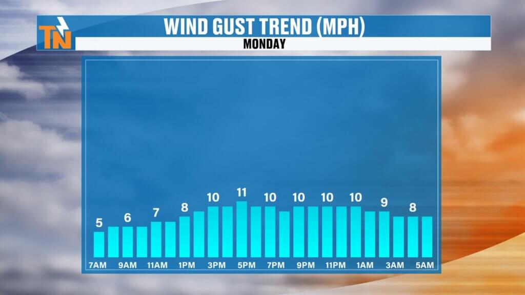
Winds remain light throughout the day.
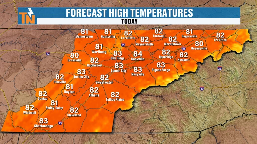
Cloud cover and rainfall will hold afternoon highs in the lower 80s, keeping temperatures below average for early July.
Humidity remains high, but cooler temperatures will prevent much of a heat index from developing today.
Improving Weather Arrives Midweek
By Tuesday, the upper-level low begins shifting away from East Tennessee.
The best chance for additional rainfall will become focused south of Interstate 40, while northern sections gradually begin drying out.
By Wednesday, the storm system finally pulls away as high pressure begins building back across the Southeast.
That means:
- More sunshine
- Warmer temperatures
- More typical summertime weather
Typical July Pattern Returns
Even though the widespread rain moves out, plenty of moisture will remain in the atmosphere.
That means we’ll transition back to the familiar summertime pattern of hot, humid afternoons with scattered pop-up thunderstorms capable of producing tropical-like downpours.
Remember, East Tennessee actually averages more annual rainfall than Seattle because our rain often falls in the form of slow-moving, moisture-rich thunderstorms.
Those daily pop-up storms will continue adding rainfall through the week, especially across southern sections of the Tennessee Valley.
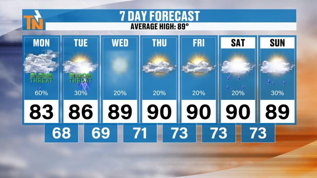
Seven-Day Outlook
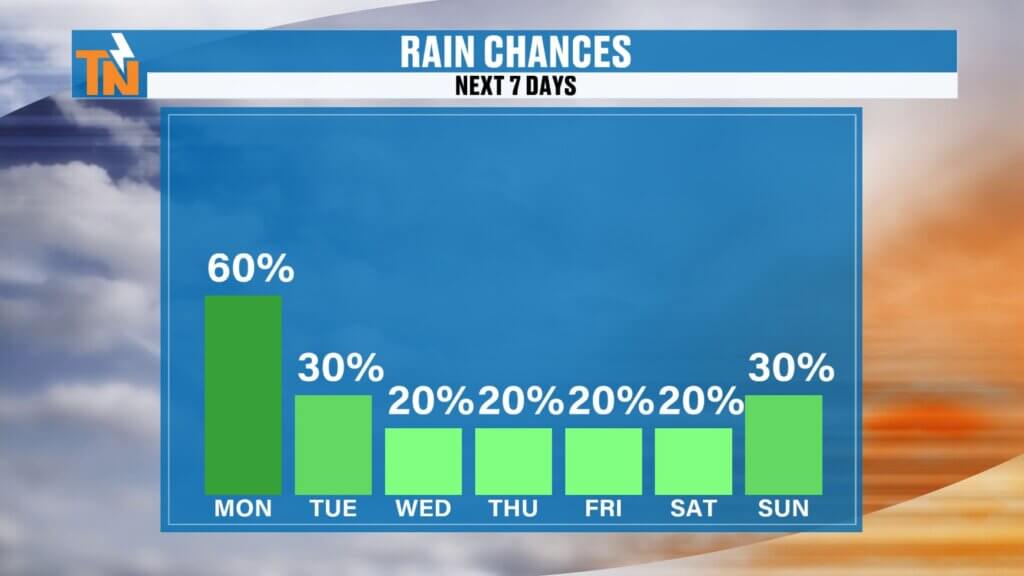
The flood threat gradually decreases after today, with only isolated concerns lingering across the southern Valley on Tuesday.
Temperatures warm back into the middle and upper 80s by midweek before approaching 90 degrees heading into the weekend.
Dew points climb back into the middle 70s, pushing afternoon heat index values close to 100 degrees.
In other words…
Typical July weather returns.
Hot.
Humid.
Hazy.
With the daily chance for an afternoon thunderstorm.
Bottom Line
Today’s biggest concern remains localized flooding and flash flooding, especially in areas that received heavy rainfall over the weekend.
Expect:
- Additional rounds of showers and thunderstorms
- Flood Watch through 8 PM
- Localized flash flooding
- Below-average temperatures
- Improving weather beginning Wednesday
Stay weather aware throughout the day, keep the East Tennessee Weather App nearby, and make sure notifications are enabled so you’ll receive Flash Flood Warnings and live weather updates as they happen.
Have a great Monday, and thanks for making East Tennessee Weather part of your morning.