
Published: Thursday, November 19, 2026 | By Meteorologist Mike Witcher | eastTNweather
Good morning, East Tennessee, and thanks for checking in with your morning weather update here on this Thursday, November 19th, 2026. Okay, I shouldn’t say good morning, because some of you watch this during the afternoon. Either way, I appreciate you being here.
It’s a wash, rinse and repeat forecast for the day today. No major changes today or tomorrow. We’ll see a few clouds increasing as we get into the upcoming weekend, and a cold front arrives Sunday into Monday that probably isn’t going to spill in a whole lot of rainfall.
So, is our storm delayed? That’s the big question for Thanksgiving travel week. There’s another storm system that’s potentially going to affect parts of the country toward the end of the week. That could mean smooth traveling on the front side of Thanksgiving, but maybe a little rough on the back side. The models have changed just a little bit, so I’m going to walk you through those changes this morning.
Yesterday's Almanac: Warm, But Not a Record
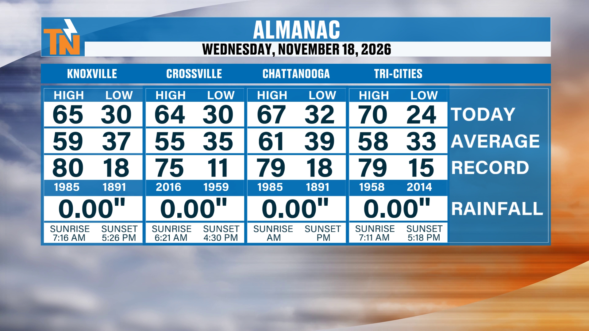
Let’s start off with the almanac from yesterday. It was a warm day, unseasonably warm, with a high of 65 degrees in Knoxville. That’s well above the average high of 59, but it was not a record-breaking warm day. The record for the date is 80 degrees, set back in 1985.
Crossville reached 64, Chattanooga hit 67 and the Tri-Cities topped out at 70. There was no rainfall at any of our four cities.
The Big Picture: Quiet Here, Stormy Out West
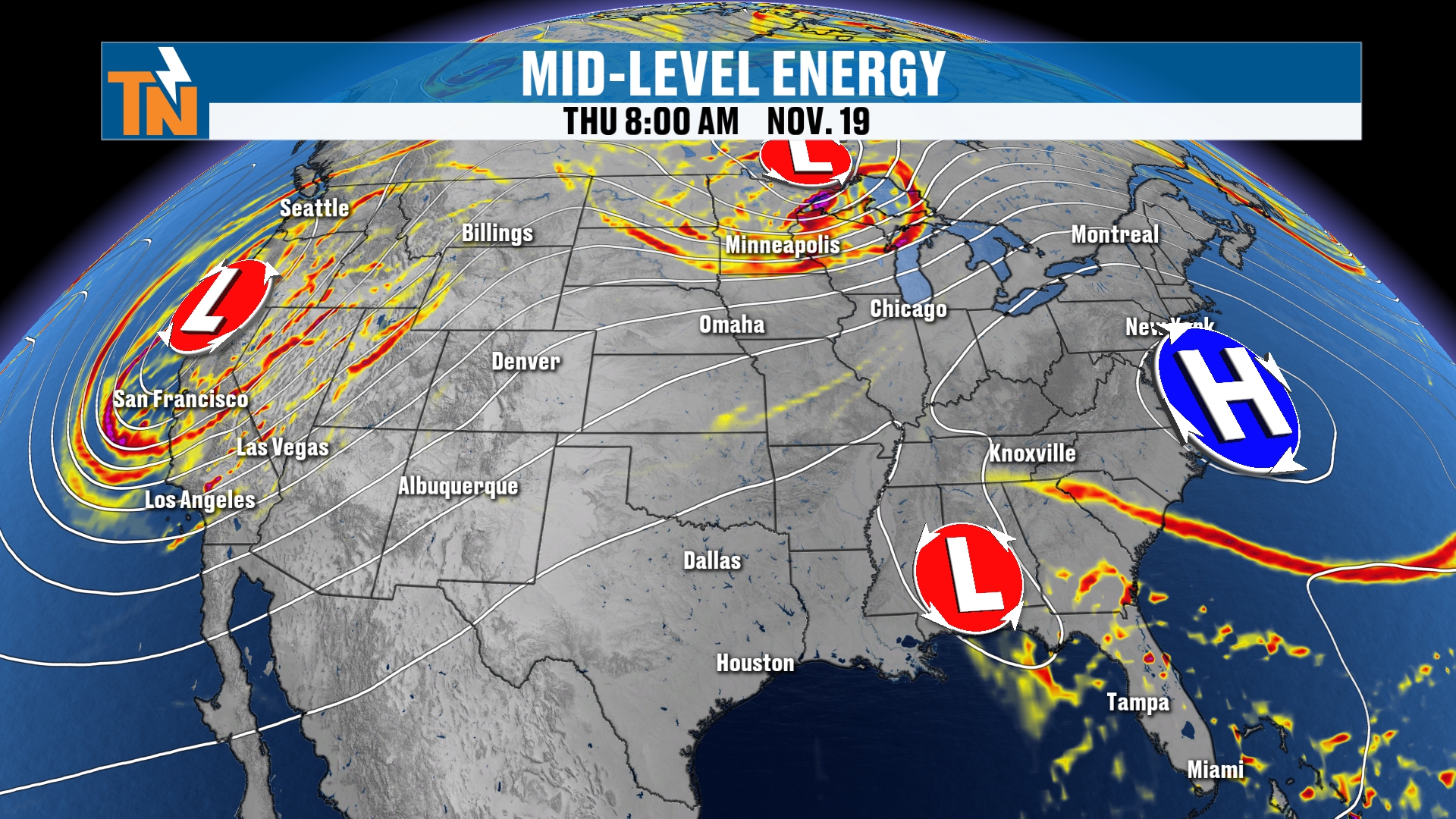
Let’s talk about the big picture story. On the upper level map you can see high pressure anchored across much of the eastern seaboard. Down near the Gulf Coast there’s a weak area of low pressure, and then a lot more storms back off to our west.
Those storms to our west are bringing in some pretty stormy weather across California, the Cascades, the Sierra Nevada, the intermountain West, the Rockies, Utah and up into Montana. Some pretty good snow showers are falling out there.
Here’s our water vapor imagery. It shows that weak little low anchored across parts of Florida, bringing in more rain showers there. That’s going to develop into another low pressure system as this trough heads our way.
And that trough is going to start to swing its way across the country and increase our chances for snow, mainly across the West Coast. So the storms are out there, but they aren’t here yet.
Now the satellite and radar. Notice the low pressure down across the coastal areas. That’s bringing in cloud coverage and showers across parts of Georgia and South Carolina.
We’re probably not going to see a whole lot of cloud coverage here throughout the day today. Maybe a few more clouds than what we saw yesterday, as some of that moisture creeps its way from south to north, but nothing major. High pressure is still doing the work for us.
Morning Temperatures: A Little Frost, Then a Quick Warm-Up
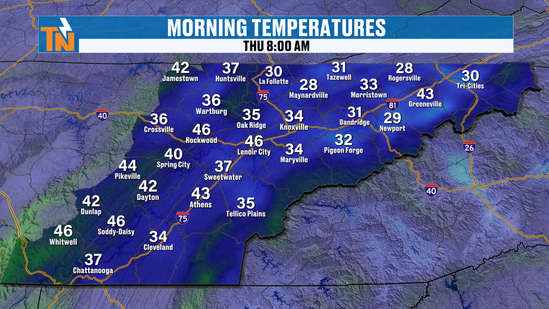
Temperatures this morning started off in the 20s and 30s, so a little bit of frost is still hanging out with us. That’s going to quickly go away as we head through the day. The 8 AM map shows how much the readings vary. Maynardville and Rogersville were at 28, La Follette and the Tri-Cities were at 30, Knoxville was 34, Crossville 36 and Chattanooga 37. Meanwhile, spots like Rockwood and Lenoir City were up around 46.
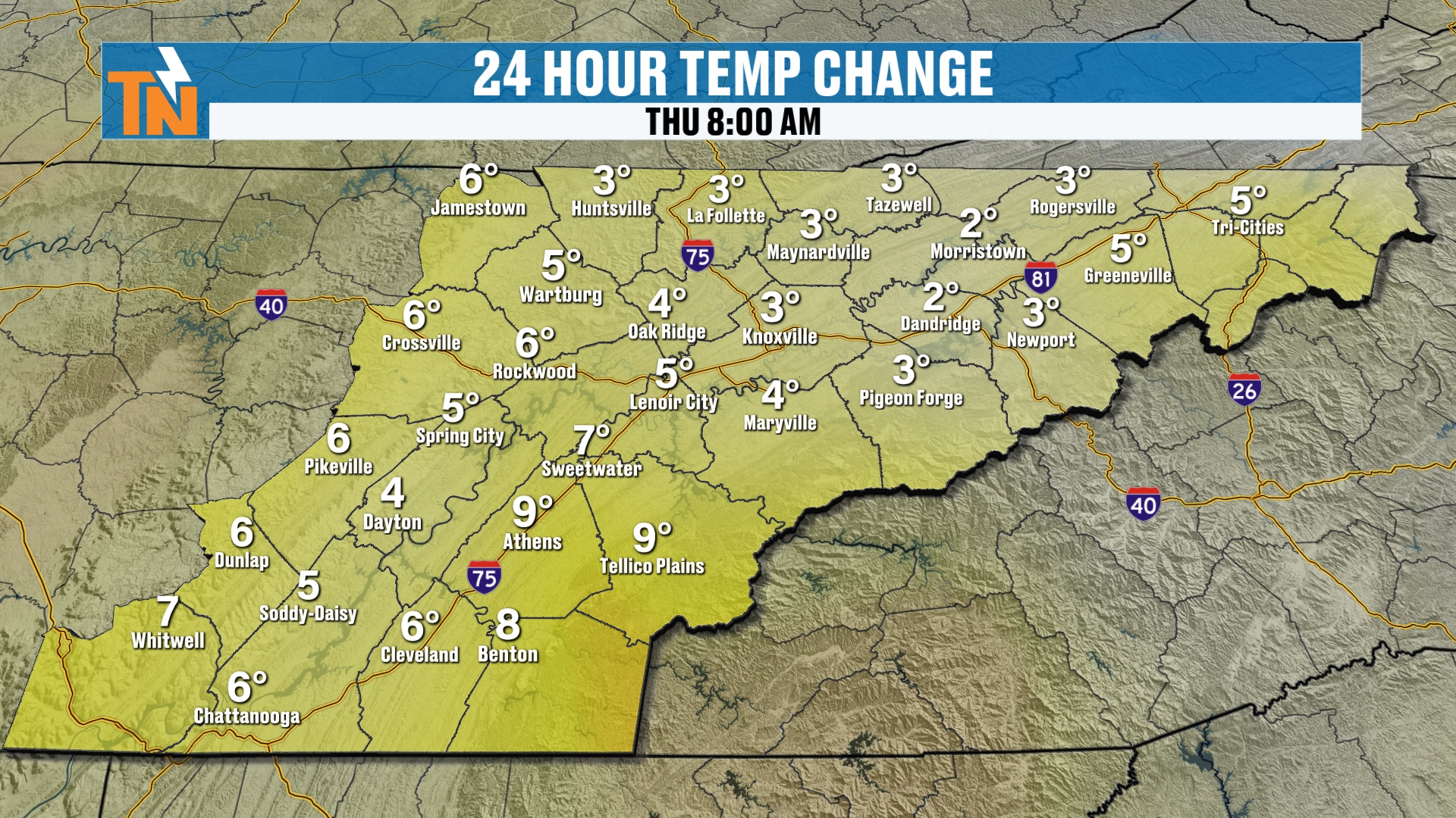
Temperatures this morning are trending warmer than the previous day, and the 24 hour change map backs that up. Knoxville is 3 degrees warmer than yesterday morning, Crossville is up 6, and Athens and Tellico Plains are up as much as 9 degrees. The warming trend is the story all week.
Today: Mostly Sunny, Mid 60s and a Little Afternoon Breeze
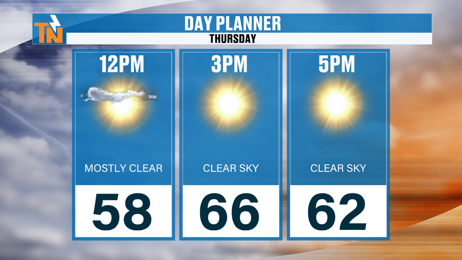
Here’s your day planner. By lunchtime we’re going to be in the upper 50s. As the kids head home from school, our forecast is for the mid 60s, pushing the upper 60s to near 70 across the southern valley.
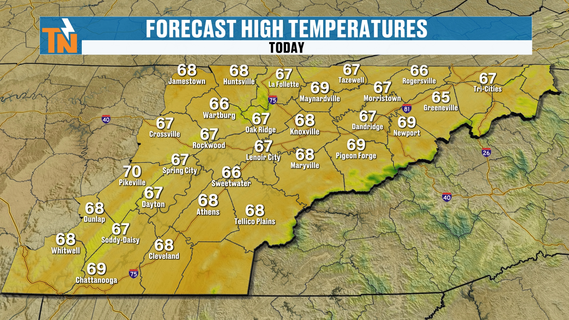
Here are the highs this afternoon. Most of us are in the upper 60s, with 68 in Knoxville, 69 in Chattanooga and 70 in Pikeville. The Tri-Cities and Greeneville are a touch cooler, in the mid 60s.
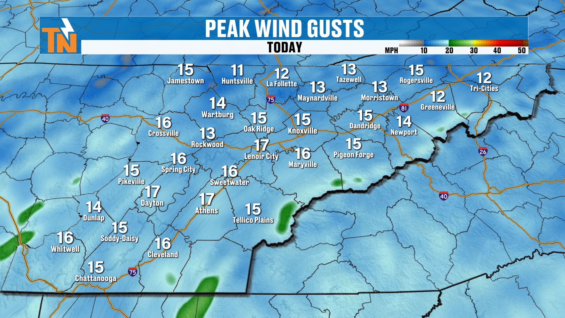
There’s also going to be a little bit of an afternoon breeze, gusting to about 10 to 15 miles per hour. A few spots, like Lenoir City, Dayton and Athens, could reach 17. That’s nothing to worry about, just a breezy feel in the afternoon.
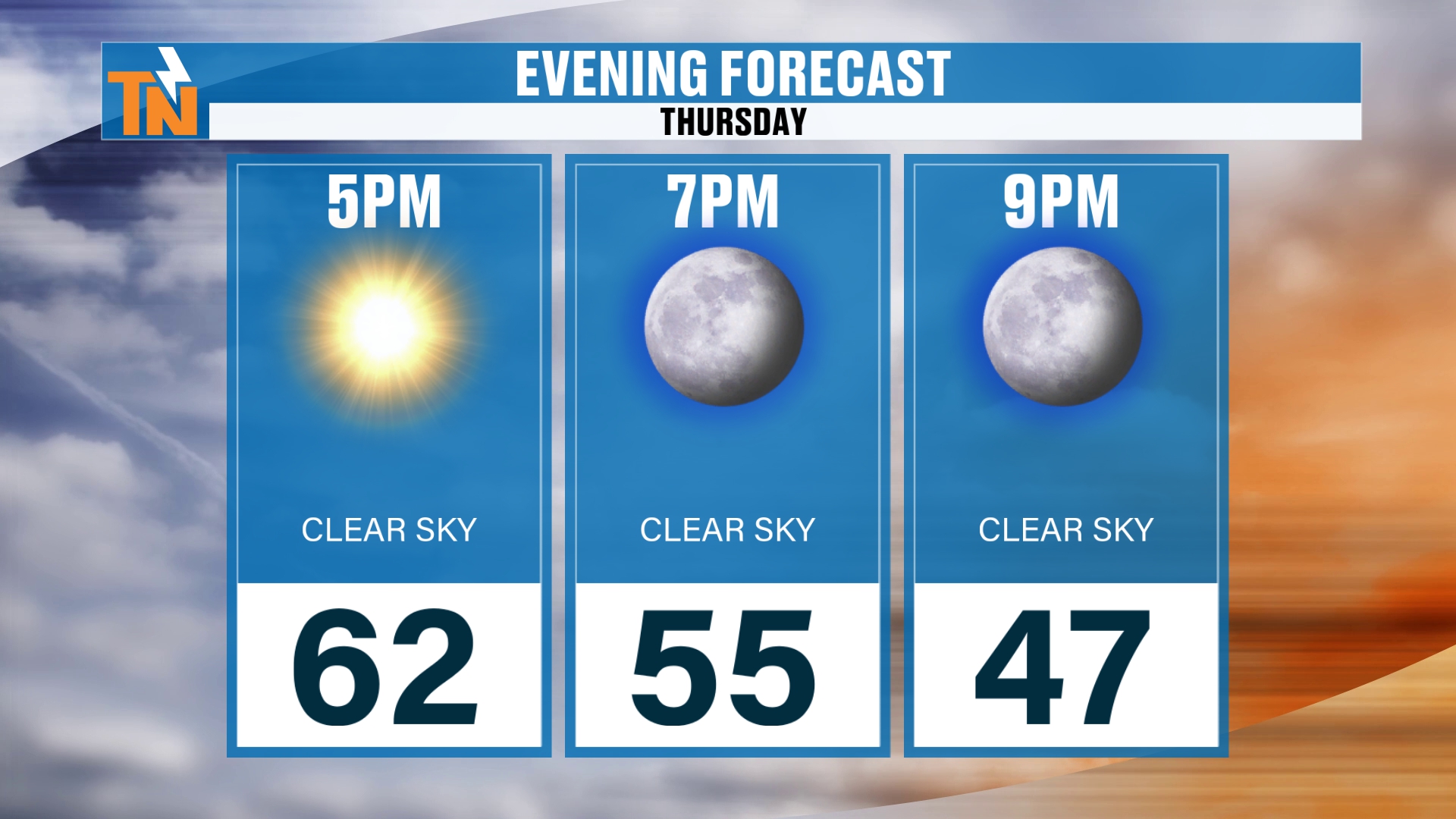
If you have evening plans tonight, at 7 PM we’re right around 55, dropping down to about 47 by 9 PM. Clear skies mean those temperatures fall fairly quickly once the sun goes down.
High Pressure Holds the Warmth Through Sunday
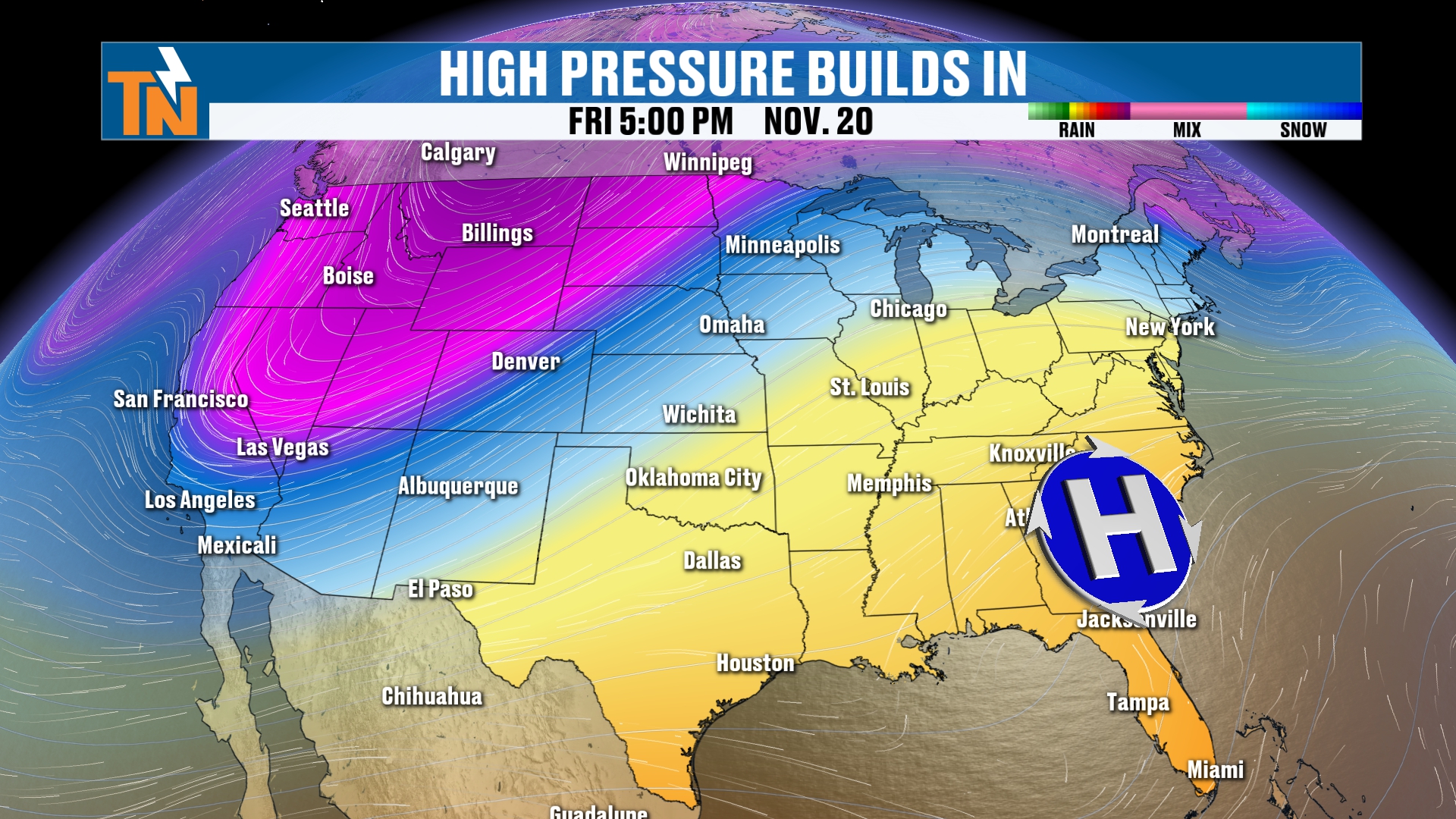
High pressure again is anchored across the southeastern coastline, and a big old trough is digging its way across the West Coast. That’s how we wrap up the work week.
And that’s really going to be the story. The warmth is going to stick with us, with the trough and the active weather back off to our west and northwest. Here locally, we’re going to stay on the warm side, in the mid to upper 60s, all the way through Sunday.
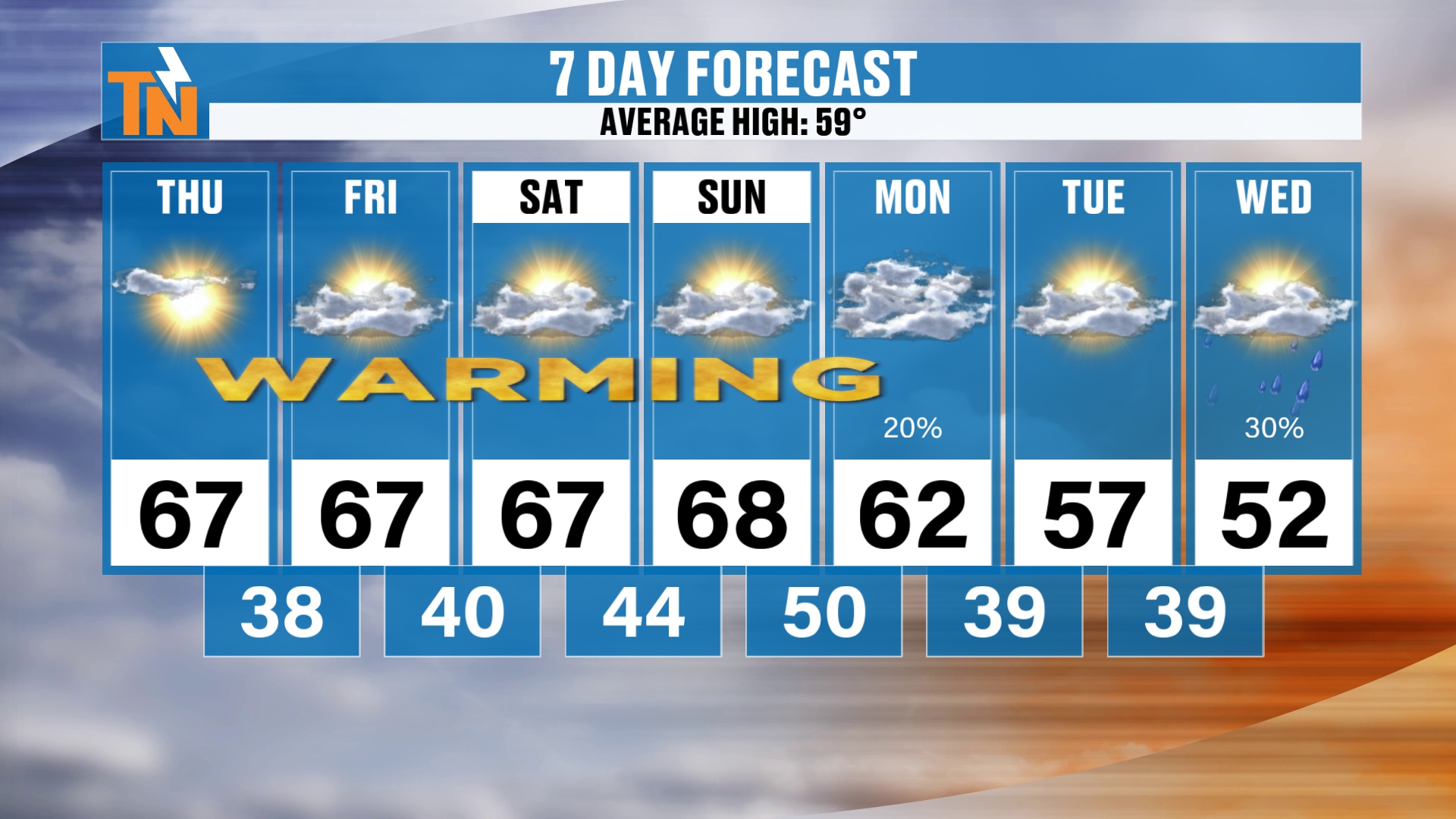
Here’s your 7 day forecast, with an average high of 59 degrees. We’re trending warmer than average for the rest of this week, with 67 Thursday, Friday and Saturday and 68 on Sunday.
Then we get into Monday and Tuesday, and that Sunday cold front is going to drop our temperatures back closer to those seasonal averages. Monday’s high is 62 and Tuesday’s is 57. Wednesday, we’re going to be a little bit below average, down to about 52.
Rain Chances: Not Much This Weekend, More Midweek
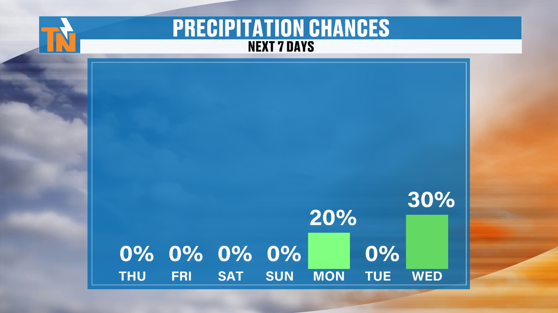
We’ll also see increasing chances for some rain showers as we get into the Wednesday, Thursday and Friday time frame. Right now we’ve got about a 30% chance on Wednesday, and a 20% chance on Monday.
That Monday chance is going to be early in the morning, so it’s likely tied to that cold front late Sunday into early Monday. This is probably not a huge chance for a whole lot of rainfall during the daytime hours on Monday, or even on Sunday. But Wednesday, we’re going to be tracking that storm system.
Our Weekend Cold Front: Not a Big Rain Maker
Before we get to that storm, let’s talk about our weekend cold front. There’s that coastal storm that’s going to bring us the cold front this weekend. I don’t know why those markers are off on the map, but let’s just ignore that for now. You get the point.
That coastal storm is not really going to bring us a whole lot of rainfall. It’s going to stay just that, coastal. And the cold front to our west kind of weakens and doesn’t produce a whole lot of rain. So there’s that cold front swinging its way on through early Monday morning.
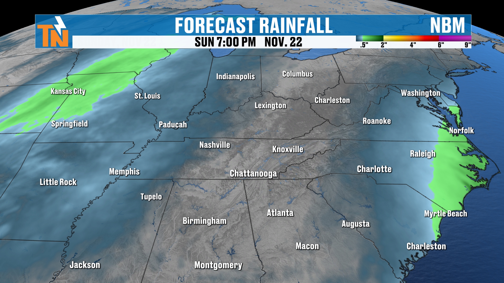
All of the models, from the GFS to the European, the National Weather Service blend of models and even the Weather Prediction Center, are predicting that this is not going to be a big rain maker this weekend. Here’s the National Blend of Models for Sunday evening, with the rain staying along the coast and East Tennessee dry.
Thanksgiving Week: Is the Storm Delayed?
Now let’s pick up our timeline on Wednesday, November 25th, the day before Thanksgiving. There are some tough travel conditions back off to our west for people traveling on Wednesday. Then from Thanksgiving Day into Friday, that storm system is going to linger across parts of the Four Corners.
As we get into the weekend, it’s going to travel its way somewhere across the midsection of the country, and maybe into the Southeast and maybe the Northeast.
So, is the storm delayed? This latest model guidance has shifted a little bit slower than what it was when we were talking about yesterday. That’s the change I mentioned at the top of the show.
The guidance does have a pocket of cooler air. But how cold is the air mass going to be by the time it works its way into our area? Well, we could see another dip in the jet stream up to our north, and that could help spark off and pull in some colder air as we get into our Sunday, Monday and Tuesday time frame.
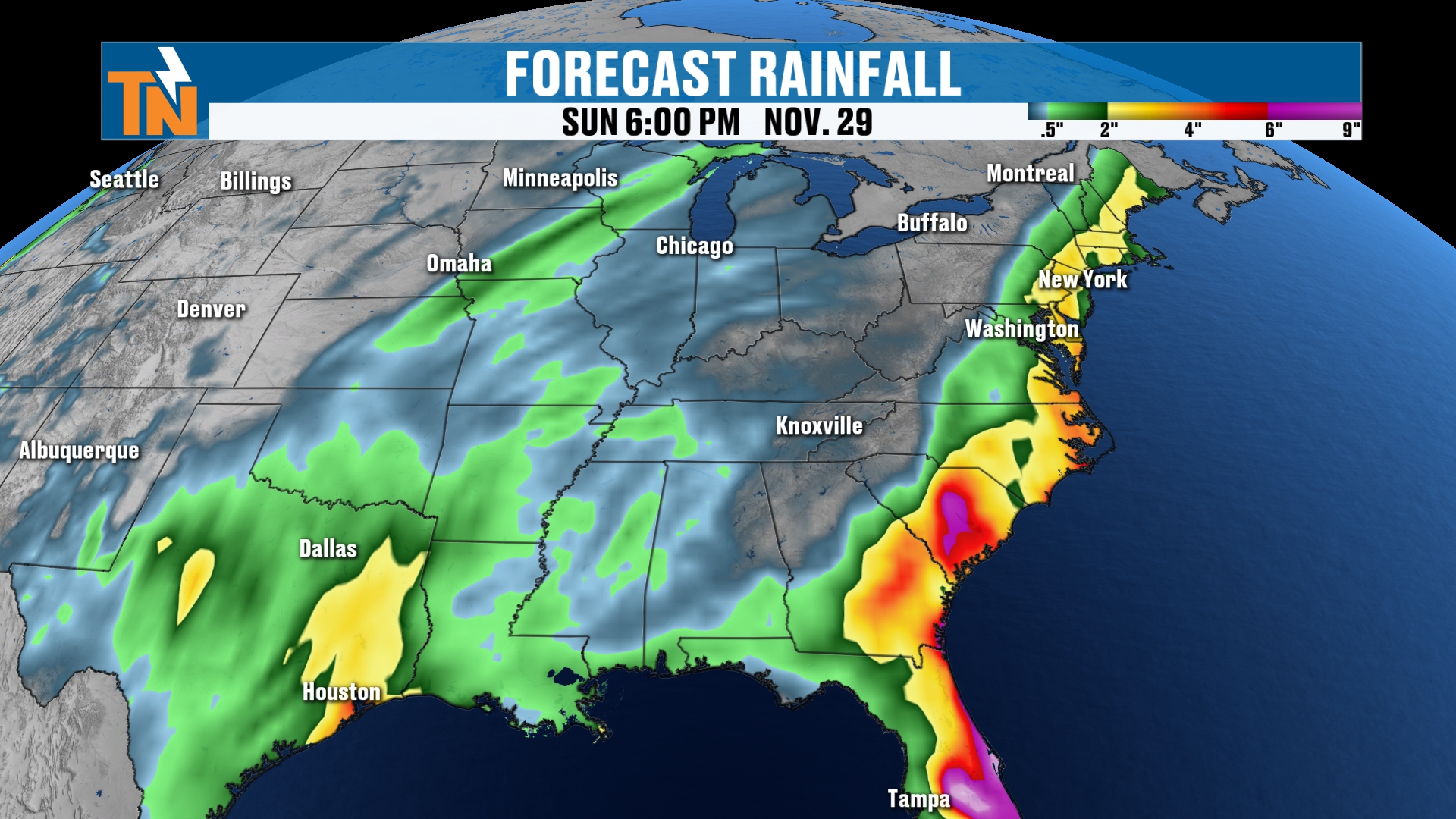
The storm system is going to bring in some rain showers around the area. The heaviest rain is going to start to increase as we get into Thursday, but more so Friday. Friday, Saturday and Sunday are probably going to be the rainier days across parts of the Southeast. Again, this is subject to change.
Snow Outlook: Rockies Get It, We Probably Don't
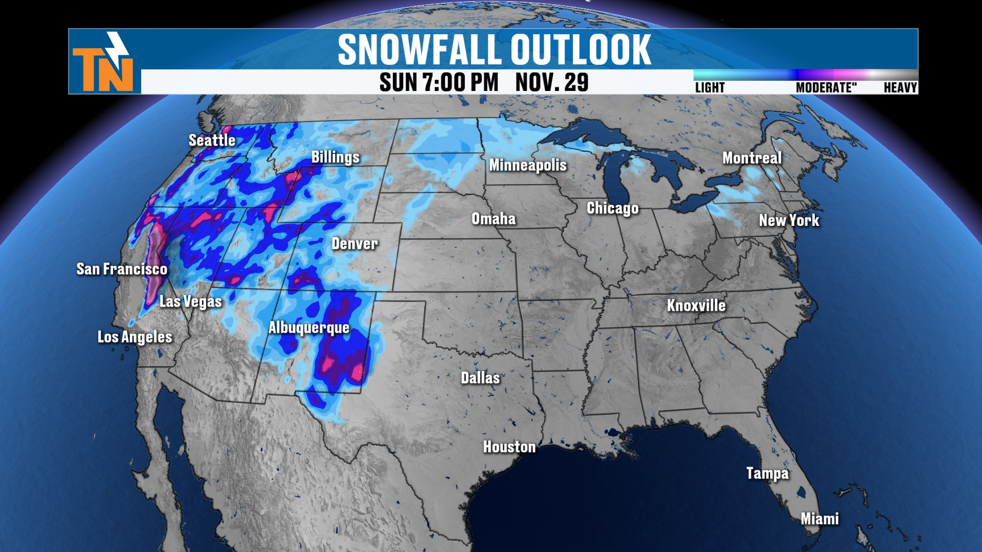
I know we were talking about snowfall yesterday. Snow is going to be falling across the Rockies from now through next Sunday, and I think that’s really going to be the story. We’re not looking at a huge chance for a lot of snowfall around here.
There could be a storm system across parts of the Great Plains and the Upper Midwest that has been advertised a couple of times, but at this point in the game, it’s not being advertised this morning.
So again, there’s going to be a lot that changes for Thanksgiving week. But it does appear there’s going to be a storm system sliding from west to east toward the end of our Thanksgiving week. Traveling to Thanksgiving is probably going to be fine across much of the country. Traveling back home, maybe not so much, depending on where you’re traveling to and from.
Take the App With You
If you’re traveling for Thanksgiving, make sure you go to your app store, search East Tennessee Weather and download my free cell phone app. It’s available for free on your tablets as well. You can also check out the apps for your smart TVs on Roku and Amazon Fire.
Bottom Line
THURSDAY (TODAY): Wash, rinse and repeat. Frost this morning, then mostly clear to sunny skies with a few more clouds than yesterday. 58 at noon, 66 at 3 PM (upper 60s to near 70 in the southern valley), and a little afternoon breeze gusting 10 to 15 mph. 62 at 5 PM, 55 at 7 PM and 47 by 9 PM.
FRIDAY AND SATURDAY: No major changes. Mid to upper 60s with a high of 67 each day and 0% chance of rain. A few clouds increase heading into the weekend.
SUNDAY: High near 68 with clouds on the increase ahead of a cold front. Not expecting a whole lot of rainfall during the daytime hours.
MONDAY: The cold front swings through early in the morning with a 20% chance of a shower, then temperatures drop closer to seasonal averages, with a high near 62.
TUESDAY: Back near average with a high around 57.
WEDNESDAY: A little below average with a high near 52 and a 30% chance for rain as we start tracking the next storm system.
THANKSGIVING WEEK: Traveling to Thanksgiving looks fine for most of the country, but the storm system appears slower than it did yesterday and could make the trip home rougher. The rainier days across the Southeast look like Friday through Sunday, snow stays mainly in the Rockies, and there’s a lot of time for the forecast to change.
The takeaway: enjoy a warm, quiet few days, and keep checking back as we fine-tune your Thanksgiving week forecast.
For more daily updates, check out our Daily Forecast page. For longer-range outlooks, you can also check the Climate Prediction Center.
Don’t forget to LIKE, SHARE and SUBSCRIBE to the YouTube channel and hit the bell at the top.
I’m Meteorologist Mike Witcher. Have a great Thursday! Thanks so much for tuning in, and I do appreciate it.
eastTNweather — Weather When You Want It.