
Good Morning, East Tennessee
Happy Memorial Day, everybody! Sure hope you have a great day.
If you’re stepping outside this morning, you’ve probably already noticed the fog, damp roads, and soggy conditions. Unfortunately, more rain is on the way as East Tennessee remains locked into a very wet weather pattern.
Why It’s Staying So Wet
The weather pattern hasn’t changed much — and that’s the problem.
High pressure remains anchored across the Southeast while low pressure spins across Texas. That setup is creating a moisture funnel straight out of the Gulf of Mexico, continuously feeding East Tennessee with deep tropical moisture.
In simple terms:
- Lots of moisture in the atmosphere
- Daily rounds of rain showers and storms
- Repeated downpours over the same areas
- Increased flooding concerns through the week
This isn’t just scattered summer rain — this is a prolonged wet pattern.d of rain we see.
Rainfall Totals Have Been Impressive
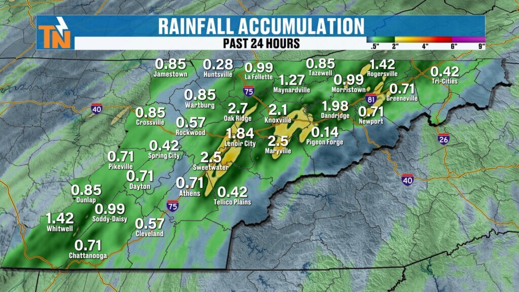
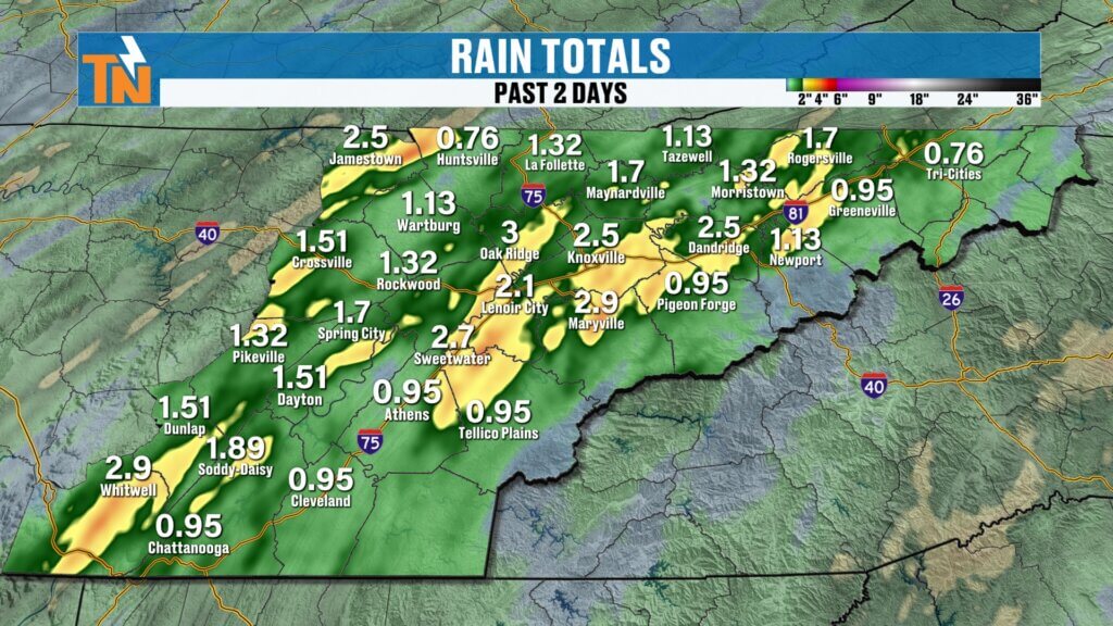
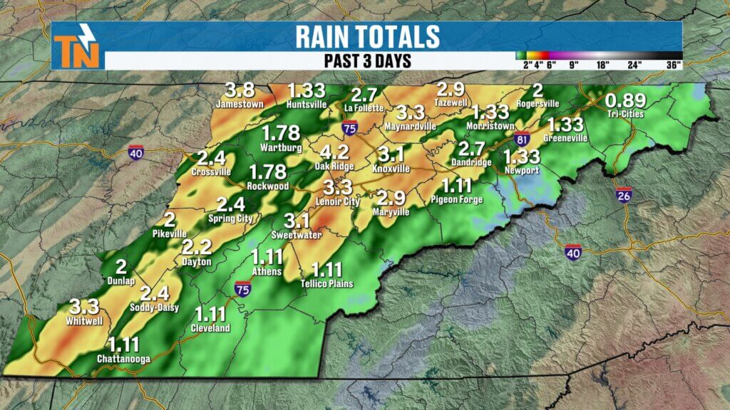
Over the last several days, rainfall totals have really started stacking up.
Some of the biggest rainfall amounts over the past 24 hours were reported in:
- Oak Ridge
- Lenoir City
- Sweetwater
- Maryville
- Knoxville
Many of these locations picked up over 2 inches of rain just in the last day alone.
Looking at the last 5 days:
- Most areas have received 2 to 5+ inches of rainfall
- Some isolated spots have picked up even more
And honestly, this is exactly the kind of drought-busting rain East Tennessee desperately needed.
Drought Improvement Is Likely
The rain may be inconvenient, but it’s doing a lot of good.
Much of East Tennessee has been dealing with moderate to extreme drought conditions, especially in areas shaded in red on the drought monitor. The amount of rain we’ve seen recently should significantly improve drought conditions in many locations.
The next official drought update arrives Thursday, and there’s a good chance we’ll see major improvements across much of the region.
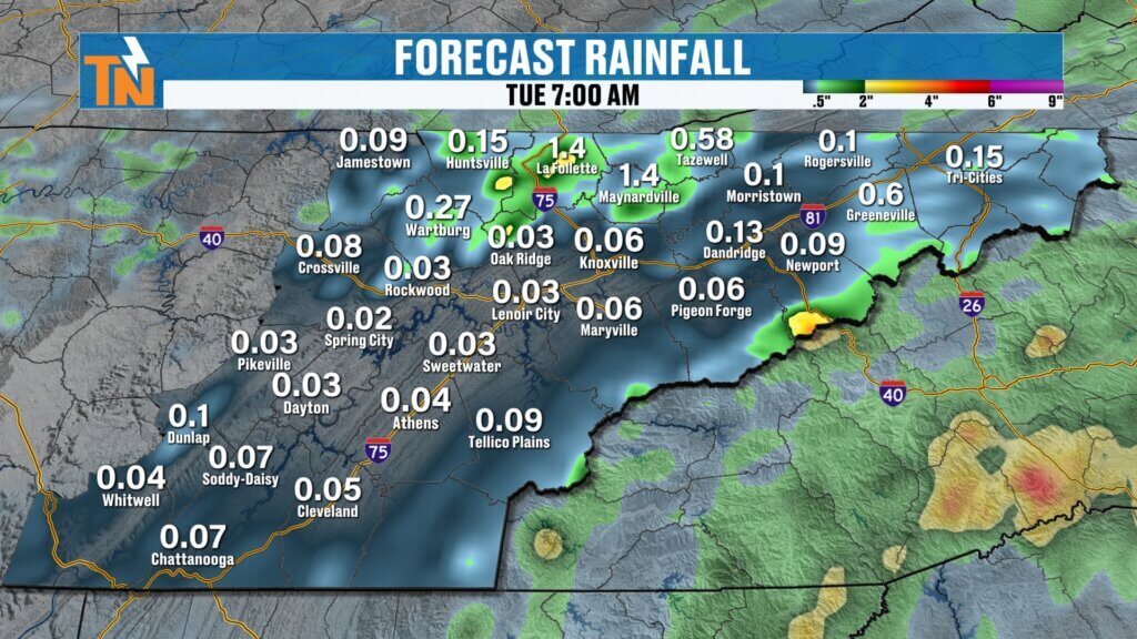
Flooding Concerns Continue Today
Now for the downside of all this rain.
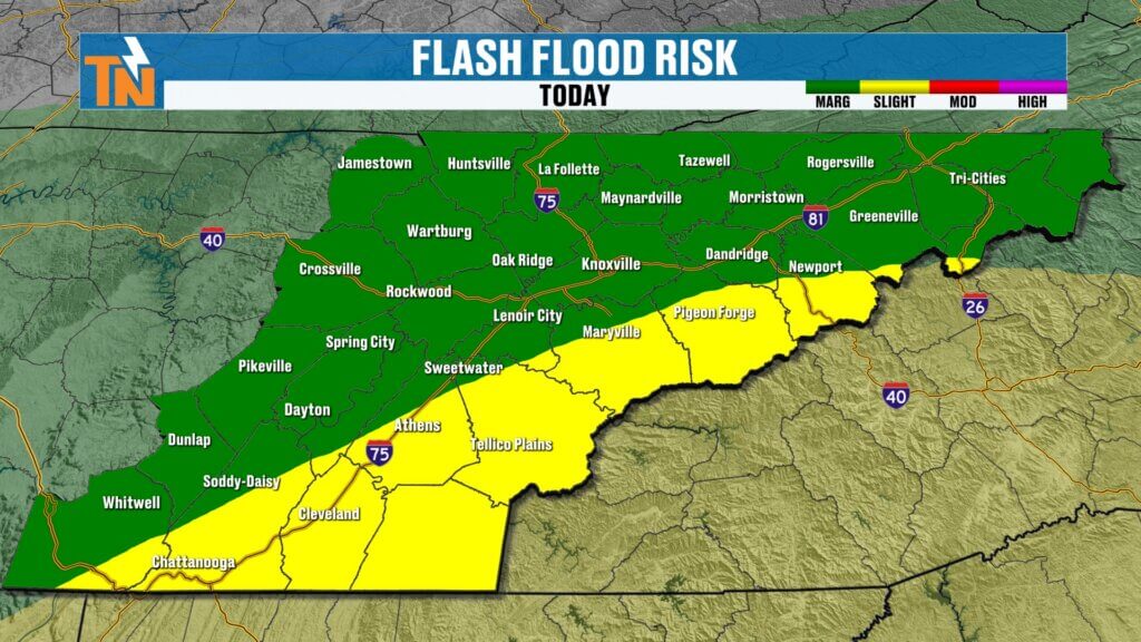
The Weather Prediction Center continues to highlight East Tennessee for a Level 1 to Level 2 flooding and flash flooding risk today.
Why?
Because the ground is becoming saturated.
If you picked up several inches of rain over the last few days, it won’t take much additional rainfall to trigger:
- Ponding on roads
- Standing water in low spots
- Localized flooding
- Isolated flash flooding concerns
Use extra caution if you run into heavier downpours.
Today’s Forecast: Dreary Start, More Rain Later
The overall vibe for Memorial Day?
Gray, damp, and humid.
What to expect:
- Fog and scattered showers this morning
- Mostly cloudy and gloomy skies through midday
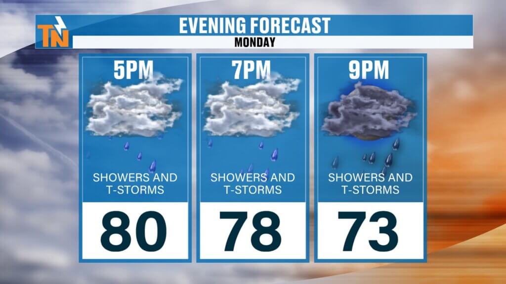
- Rain showers increasing again this afternoon and evening
- More widespread rain tonight
Rainfall today won’t be as heavy as what some communities saw over the weekend, but additional accumulation is expected.
Mild and Muggy Temperatures
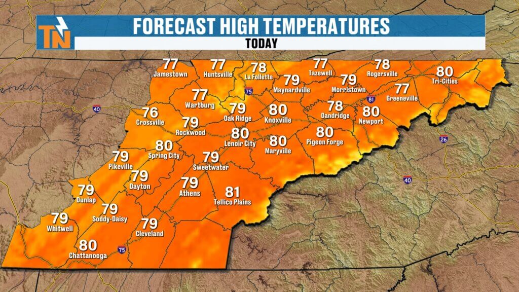
Temperatures today stay warm and humid.
Morning lows:
- 60s to near 70°
Afternoon highs:
- Knoxville: Around 80°
- Chattanooga: Near 80°
- Tri-Cities: Upper 70s
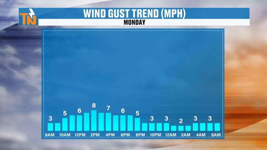
Humidity stays elevated, but winds won’t be much of an issue today. r elevations. It won’t feel cool, but it also won’t be excessively hot — just warm, humid, and damp.
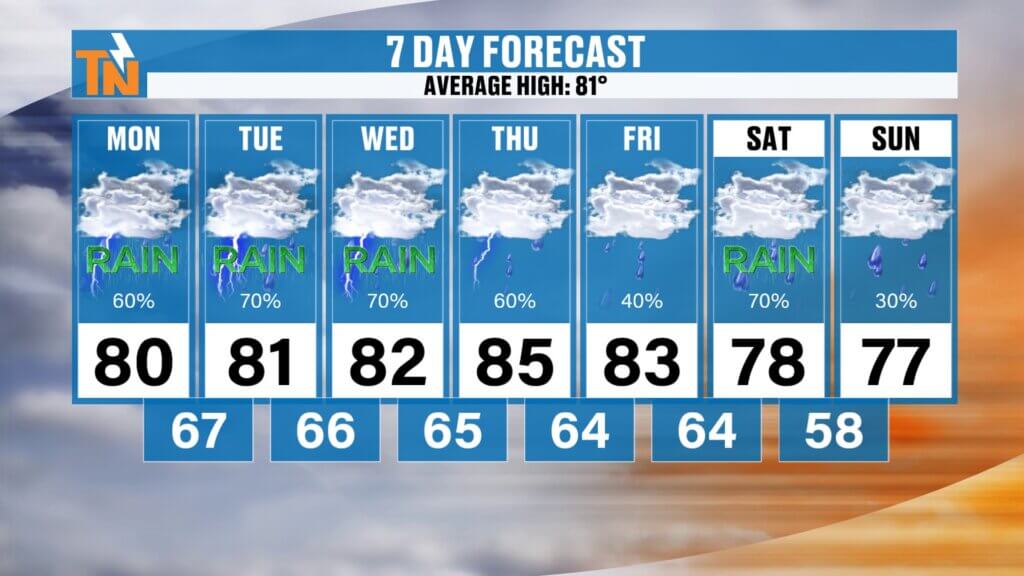
Brief Break Later This Week
There is some good news.
A backdoor cold front arrives Thursday into Friday, which should temporarily lower humidity and reduce rain chances for a short time.
But don’t get too excited just yet…
More rain returns for next weekend, including Saturday and Sunday to wrap up the month of May.
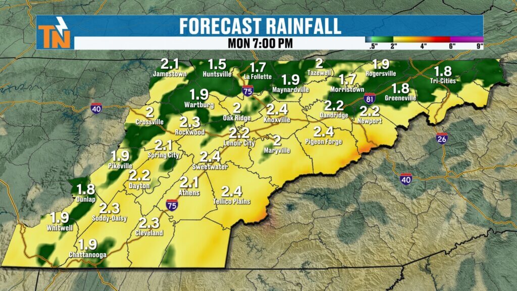
7-Day Rainfall Totals Add Up
Looking ahead, East Tennessee could still pick up:
- 1 to 3 more inches of rain over the next 7 days
- Higher localized totals where storms repeatedly track over the same spots
Bottom line: the rain isn’t over yet. Keep the umbrella handy, watch for localized flooding, and enjoy the fact that East Tennessee’s drought is finally getting some much-needed relief.