
Good morning and happy Thursday.
Thanks for checking in with your East Tennessee morning weather update. It’s a wet and chilly start to the day, and we’re tracking a weather system that will bring rain early this morning before transitioning to snow showers across parts of the region as colder air sweeps into the Tennessee Valley.
This marks a noticeable change in the weather pattern after the recent stretch of spring-like warmth. While the transition will be brief, it will remind us that winter is not quite finished yet.
Let’s break down what to expect today and through the upcoming weekend.
Rainy Start to Thursday Across East Tennessee
The day is starting with steady rain showers moving across the region, as a low-pressure system tracks through the southeastern United States.
Most of the stronger storms and severe weather activity stayed well south of the system overnight, impacting parts of Alabama and Georgia.
Here in East Tennessee, the primary impact early this morning is simply steady rainfall moving west to east across the region.
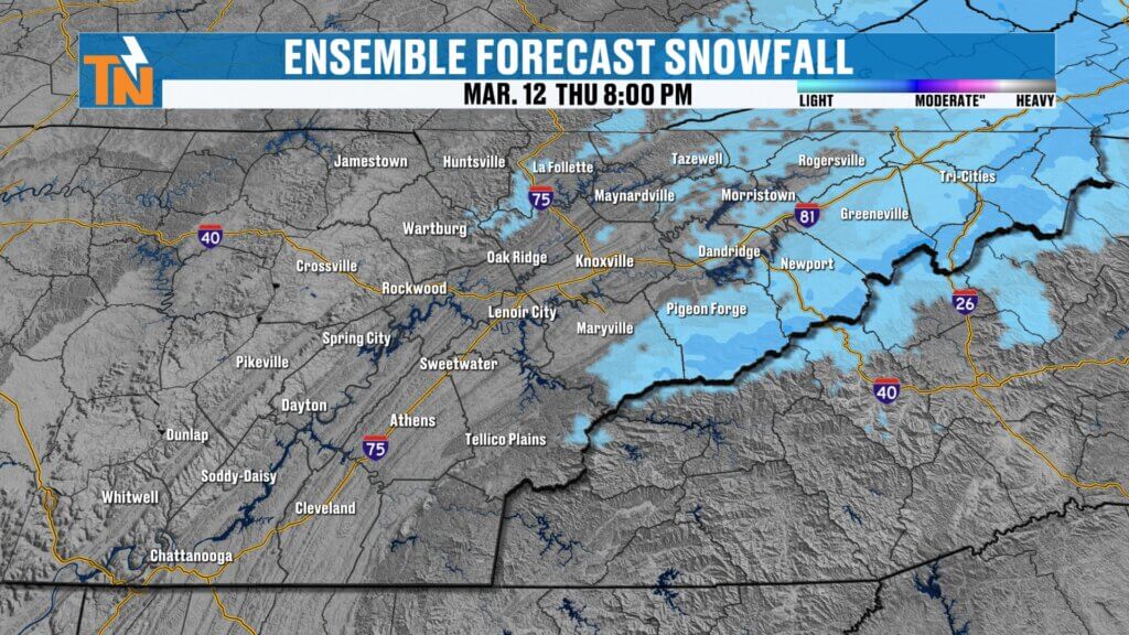
Rain Changing to Snow in Higher Elevations
As colder air pushes into the region behind the system, some locations will begin to see rain transition to snow showers, especially in higher elevations.
The transition zone will primarily affect:
- Cumberland Plateau
- Tennessee–Kentucky border counties
- Southwest Virginia
- Upper East Tennessee
- Great Smoky Mountains
By around 9 to 10 AM, snow showers may develop across the mountains and parts of Upper East Tennessee.
Expected Snowfall Totals
- Higher elevations of the Smokies: 1–2 inches
- Northern Plateau / Upper East Tennessee: Light snow or flurries
- Valley locations: Mainly rain with little to no accumulation
Ground temperatures remain warm after recent mild weather, so travel problems are not expected.
Still, seeing snowflakes fly is a reminder that Old Man Winter can still make a late-season appearance.
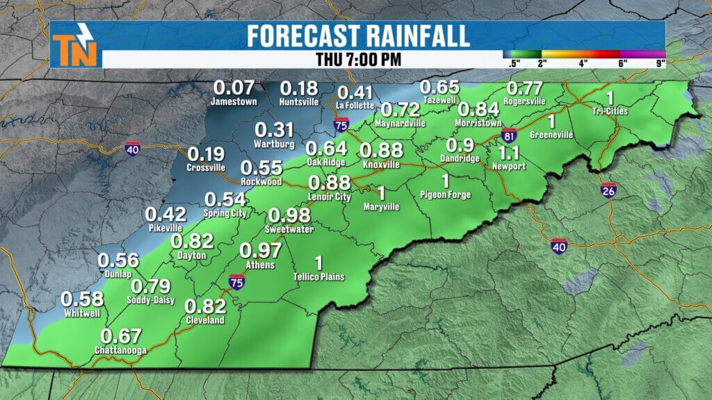
Rainfall Totals from This System
Before the rain exits later this morning, the region will pick up a solid soaking rainfall.
Expected rainfall amounts include:
- Around 0.50 inches to over 1 inch in some areas
This rainfall will help provide beneficial moisture across the region.
Turning Breezy but Sunny This Afternoon
Once the morning rain and snow showers move out, conditions will improve quickly.
By late morning into the afternoon, skies will begin clearing and sunshine will return.
However, it will be noticeably cooler and breezy.
Expect:
- Gusty winds
- Increasing sunshine
- Cooler afternoon temperatures
You’ll likely need both a jacket and sunglasses this afternoon.
Clear skies will return tonight as the system moves out of the region.
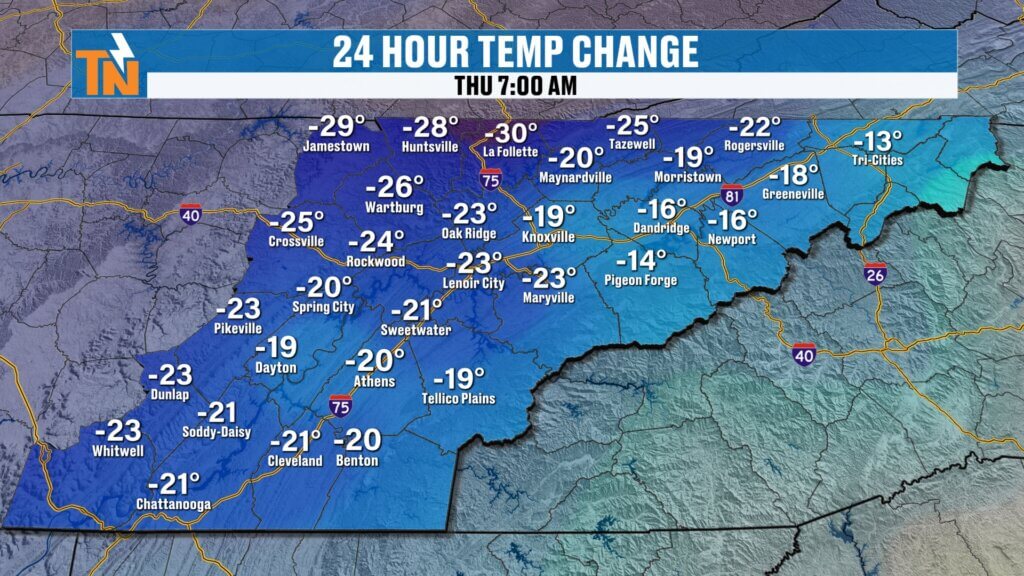
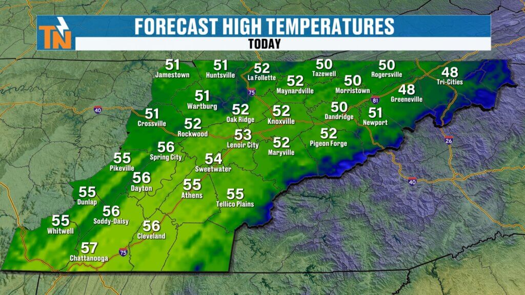
Much Colder Temperatures Today
Today’s temperatures will feel dramatically colder compared to earlier this week.
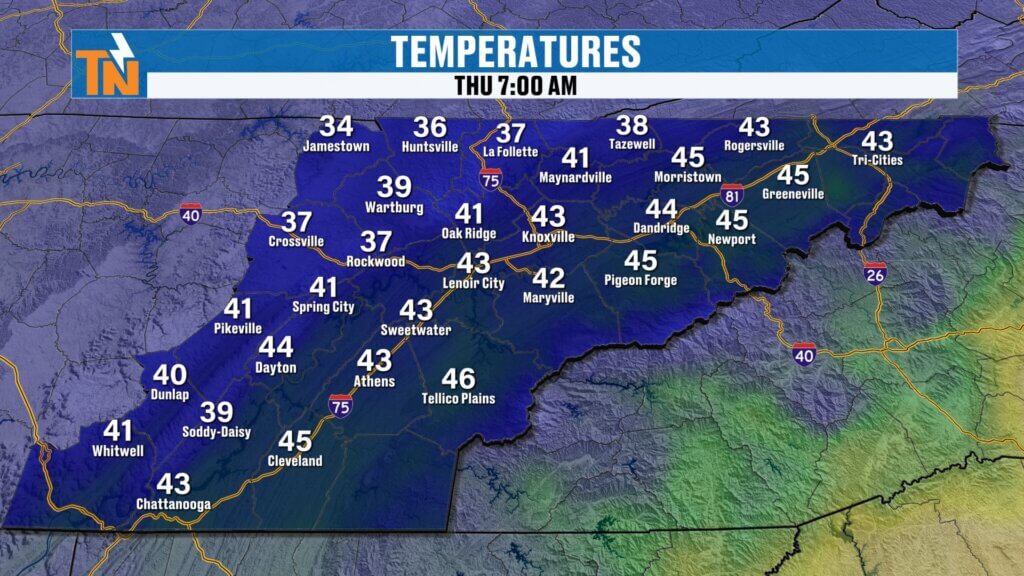
Many areas are starting the morning 15 to 30 degrees colder than yesterday.
Early morning temperatures include:
- Fentress County: around 35°
- Knoxville: around 45°
- Pigeon Forge: near 46°
Afternoon highs will struggle to climb much, topping out only in the 40s and low 50s across the region.
Warm Weather Returns for the Weekend
After today’s brief cool-down, temperatures will rebound quickly heading into the weekend.
High pressure builds back into the region, bringing dry conditions and a warming trend.
Weekend Temperatures
- Friday: near 63°
- Saturday: low to mid 70s
- Sunday: mid 70s with increasing clouds
It will feel much more like spring again by Saturday.
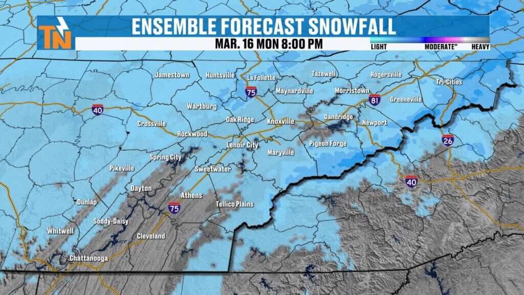
Next Storm System Arrives Late Sunday Into Monday
Another weather system will approach the region late Sunday night into early Monday morning.
This system is associated with a deep trough digging into the eastern United States, which will bring another round of rain and potentially colder air.
Timeline for the Next System
Sunday
- Mostly dry during the day
- Clouds increasing
Sunday Night
- Rain showers developing
Monday
- Rain continues early
- Temperatures begin falling through the day
Behind the system, colder air will once again move into the region.
Could Snow Return Early Next Week?
As colder air moves in behind Monday’s storm system, some areas may once again see a rain-to-snow transition, particularly in higher elevations.
Forecast models suggest:
- Up to an additional inch of rainfall possible
- Colder air spilling into the region
- Some snow showers possible in the mountains
Valley locations are unlikely to see accumulating snow due to recent warmth and marginal temperatures.
Temperature Trend Into Next Week
The weather pattern becomes cooler after the early-week system.
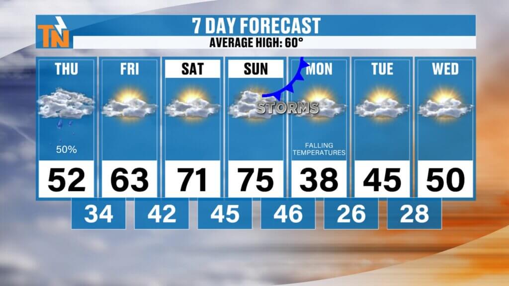
Expected High Temperatures
- Thursday: around 52°
- Friday: near 63°
- Saturday: low to mid 70s
- Sunday: mid 70s
- Monday: falling temperatures through the day
- Tuesday–Wednesday: highs in the 40s and 50s
This will place temperatures below seasonal averages for a few days next week.
East Tennessee 7-Day Weather Outlook
- Thursday: Rain changing to snow showers early, breezy with highs near 52°
- Friday: Mostly sunny and warmer, highs near 63°
- Saturday: Sunny and mild, highs in the 70s
- Sunday: Increasing clouds, showers late
- Monday: Rain early, temperatures falling
- Tuesday: Cooler with highs in the 40s
- Wednesday: Continued chilly weather
Final Thoughts
East Tennessee is experiencing a quick return to colder weather today with rain changing to snow showers in some areas, especially across the mountains and higher elevations.
While the cooler temperatures will be noticeable, the good news is that sunshine returns later today and warmer weather returns quickly for the weekend.
Another storm system arrives late Sunday into Monday, bringing more rain and possibly another brief shot of colder air.
Keep an eye on the radar this morning, and if you’re in higher elevations, you may see a few snowflakes before the system moves out.
Have a great Thursday and stay warm.