
Happy Friday and thanks for checking in with your East Tennessee morning weather update. We have a lot to talk about today as record-breaking warmth continues across the Tennessee Valley, but a strong cold front approaching from the west could bring isolated strong to severe thunderstorms on Saturday.
While today will remain mostly quiet and warm, conditions will begin to change this weekend as a storm system moves closer to the region. Let’s walk through the forecast and what you need to know.

Record-Breaking Warmth Expected Across East Tennessee
A large trough of low pressure developing across the western United States is helping to create a strong ridge of high pressure across the eastern half of the country. This ridge is allowing warm air to surge northward across the Southeast.
The result is well above-average temperatures across Tennessee, with some areas approaching record highs.
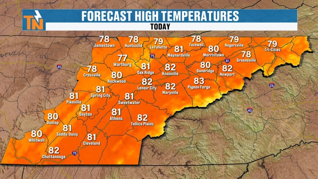
Forecast High Temperatures Today
- Knoxville: 82° (record is 79° set in 2022)
- Athens: 81°
- Dandridge: near 80°
- Wartburg: around 77°
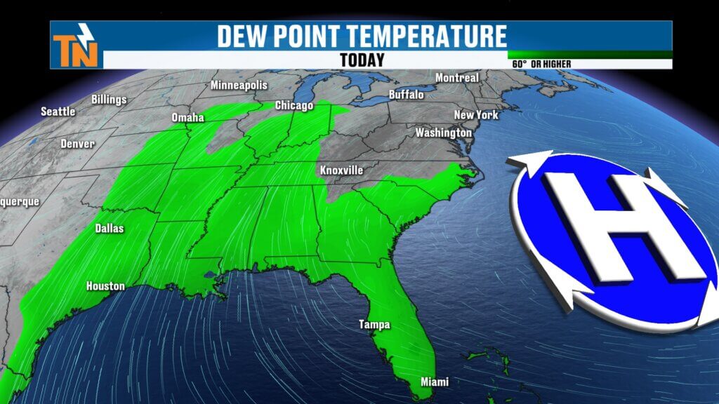
Increasing Humidity and Instability Ahead of Weekend Storms
As this warm pattern continues, southwesterly winds will begin pulling more moisture into the Tennessee Valley.
You’ll notice this in the form of rising dew points, which are expected to climb into the 60s by Saturday. Higher dew points mean more moisture in the atmosphere and more fuel for thunderstorm development.
This increase in humidity, combined with daytime heating, will lead to greater atmospheric instability heading into Saturday afternoon.
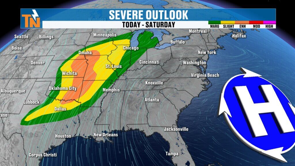
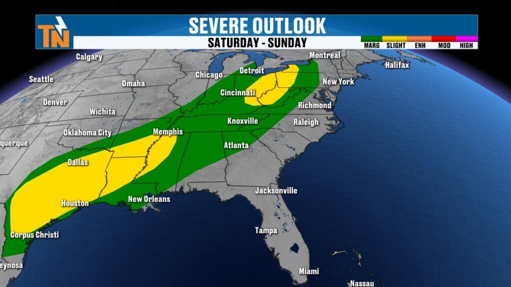
Severe Weather Risk Shifts East This Weekend
Currently, the Storm Prediction Center has issued multiple severe weather outlooks across the Plains and Mississippi Valley, where storms will be strongest.
However, as the storm system moves east, East Tennessee will enter a Level 1 severe weather risk zone by Saturday.
This means:
- Isolated strong thunderstorms are possible
- A few storms could briefly become severe
While widespread severe weather is not expected locally, conditions will be favorable for a few stronger storms Saturday afternoon and evening.

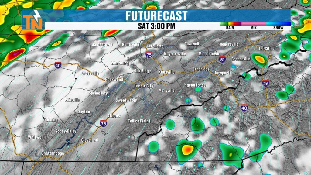
Saturday Timeline: When Storms Could Arrive
Saturday begins warm and humid, with temperatures starting in the low to mid 60s early in the morning.
Storm Development Timeline
Saturday Morning
- Mild and mostly cloudy
- Temperatures already in the 60s
Late Morning through Early Afternoon
- Mostly dry through noon
- Instability builds as temperatures rise
After 3 PM
- Line of showers and thunderstorms begins moving toward East Tennessee
3 PM – 5 PM
- Storms approach western parts of the region
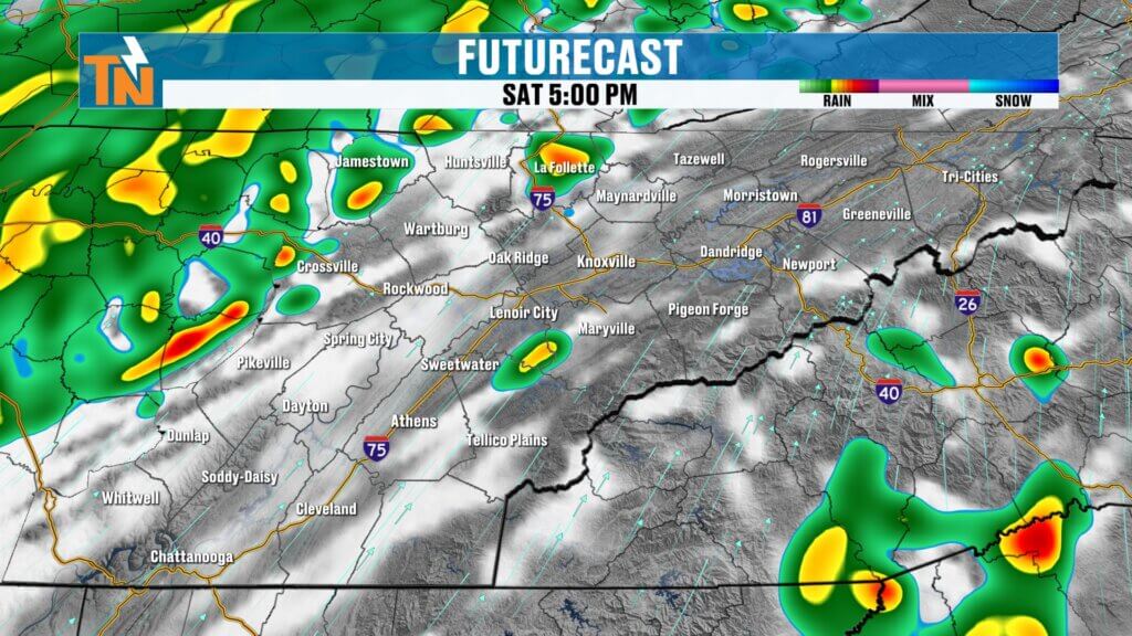
5 PM – 7 PM
- Storms move into the Tennessee Valley
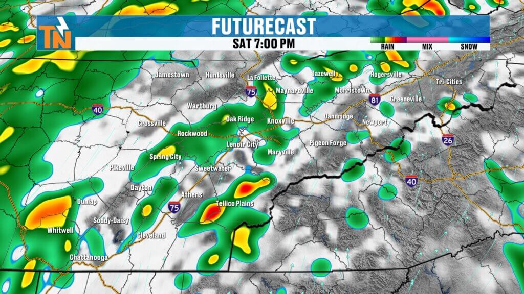
7 PM – 9 PM
- Storms move through East Tennessee
As storms move eastward, the severe weather risk should gradually decrease, though gusty winds and lightning will remain possible.
Main Storm Threats Saturday
While this does not appear to be a widespread severe weather outbreak locally, a few storms could become stronger.
Possible impacts include:
- Strong wind gusts
- Frequent lightning
- Heavy downpours
- Brief isolated strong storms
The timing of storms will play a role in their intensity. If storms arrive during peak afternoon heating, they may briefly intensify.
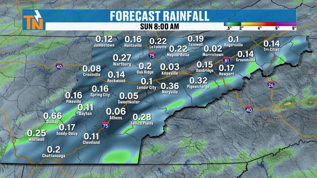
Rainfall Totals from the Weekend System
Rainfall amounts with this system will generally be light to moderate but beneficial.
Expected totals include:
- ¼ inch to ½ inch of rainfall across East Tennessee
- Locally higher amounts possible in isolated areas
Showers will likely linger Saturday night into Sunday morning before gradually decreasing.
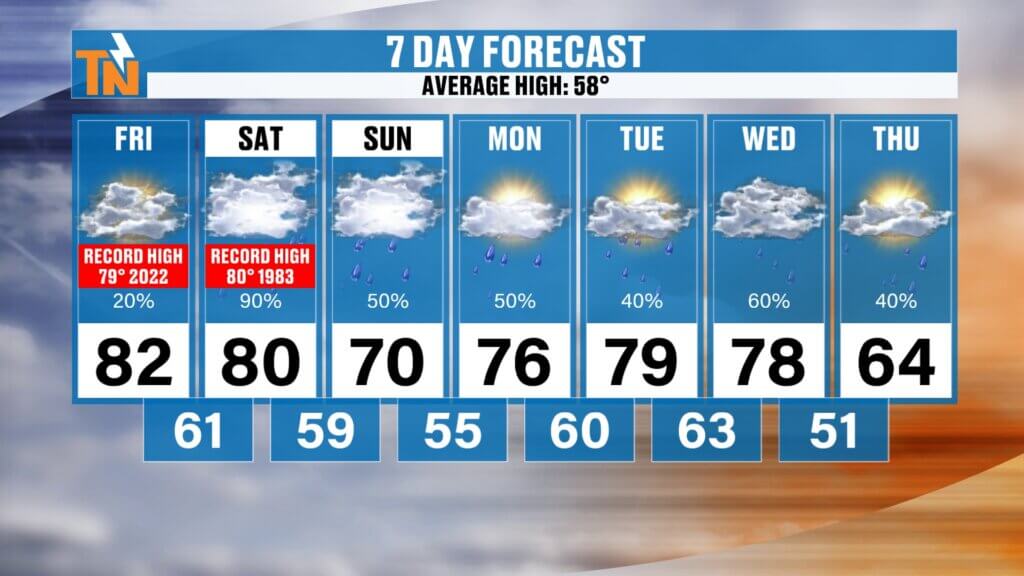
Sunday Forecast: Cooler but Still Above Average
Behind the cold front, temperatures will cool slightly but remain warmer than normal.
Sunday will feature:
- Highs in the 70s
- Lingering showers early
- Mostly cloudy conditions through the day
No record temperatures are expected Sunday.
Spring Break Forecast: Warm but Unsettled
Looking ahead to next week, many families across East Tennessee will be on spring break, and unfortunately the weather pattern looks somewhat unsettled.
Expect:
- Continued above-average temperatures
- Highs in the 70s and 80s
- Periodic rain chances throughout the week
While it won’t rain every day, scattered showers and storms will be possible at times.
Late Week Cool Down Possible
Toward the end of next week, a pocket of cooler air may finally move into the region.
Temperatures could begin trending closer to seasonal averages by Thursday or Friday, bringing highs back closer to normal for mid-March.
For reference:
- Average high this time of year: 58°
So even the cooler days next week will still feel relatively mild compared to seasonal norms.
East Tennessee 7-Day Weather Outlook
- Friday: Record warmth possible, highs near 82°
- Saturday: Warm and windy, storms possible after 3 PM
- Saturday Night: Storms moving through the region
- Sunday: Cooler with lingering showers
- Monday – Wednesday: Warm with scattered rain chances
- Late Week: Gradual cool down toward seasonal averages
Stay Weather Aware This Weekend
Because storms are possible Saturday afternoon and evening, it’s important to stay weather aware.
The East Tennessee Weather App is one of the easiest ways to stay updated with:
- Real-time lightning alerts
- Watches and warnings from the National Weather Service
- Interactive radar
- Two-hour future radar tracking
If storms strengthen Saturday afternoon, I’ll be live with updates right on the app.
Thanks again for checking in this morning. Stay weather aware this weekend, enjoy the warm temperatures today, and have a great Friday.