
Published: Sunday, August 23, 2026
By Meteorologist Mike Witcher | eastTNweather
The Air You Can ENJOY Is Here! | Beautiful Weather Before Storms Return
Good morning and Happy Sunday!
What a difference a cold front makes!
We’re starting this Sunday with clear blue skies, some patchy river and lake fog, and a gorgeous sunrise across East Tennessee.
More importantly, step outside and you’ll immediately notice something different:
The humidity is DOWN.
After weeks of talking about the “air you can wear,” we’ve finally got some air you can enjoy!
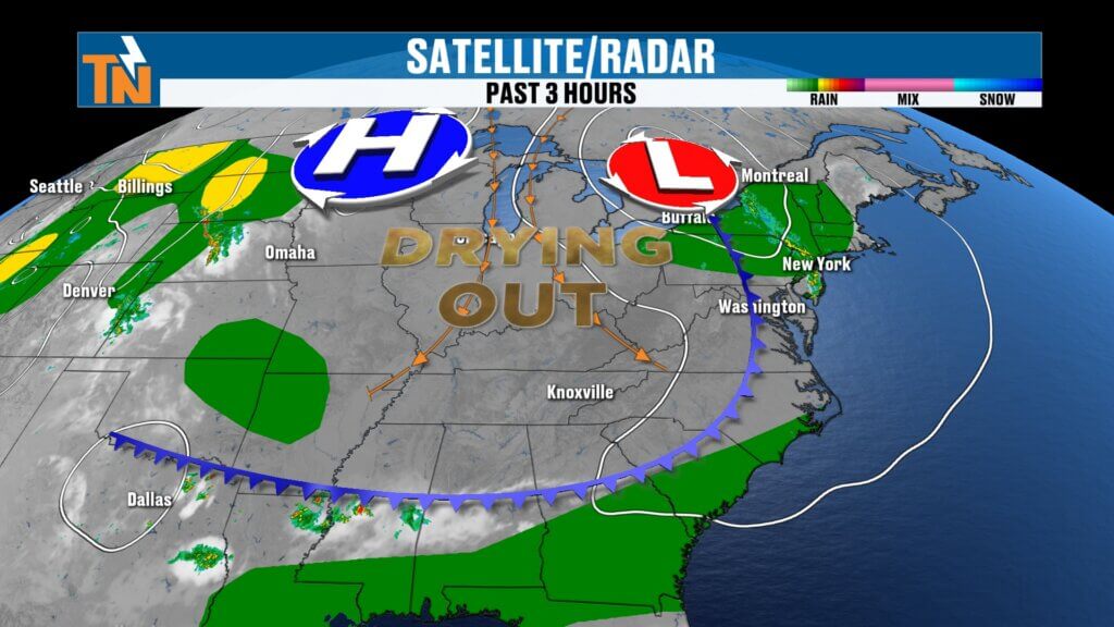
The Cold Front Delivered
Yesterday, temperatures climbed into the mid and upper 80s with some lower 90s around the region, and we dealt with scattered showers and thunderstorms.
Today is completely different.
A large trough has developed across the Great Lakes and eastern United States while high pressure builds into the Upper Midwest.
At the surface, that high pressure is giving us a northerly flow, pulling noticeably drier air into East Tennessee.
That’s the big story.
We’re not necessarily talking about dramatically colder temperatures, but when you lower the dew point, you lower the humidity—and suddenly those same summertime temperatures feel MUCH better.
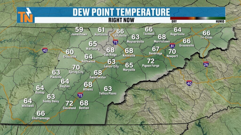
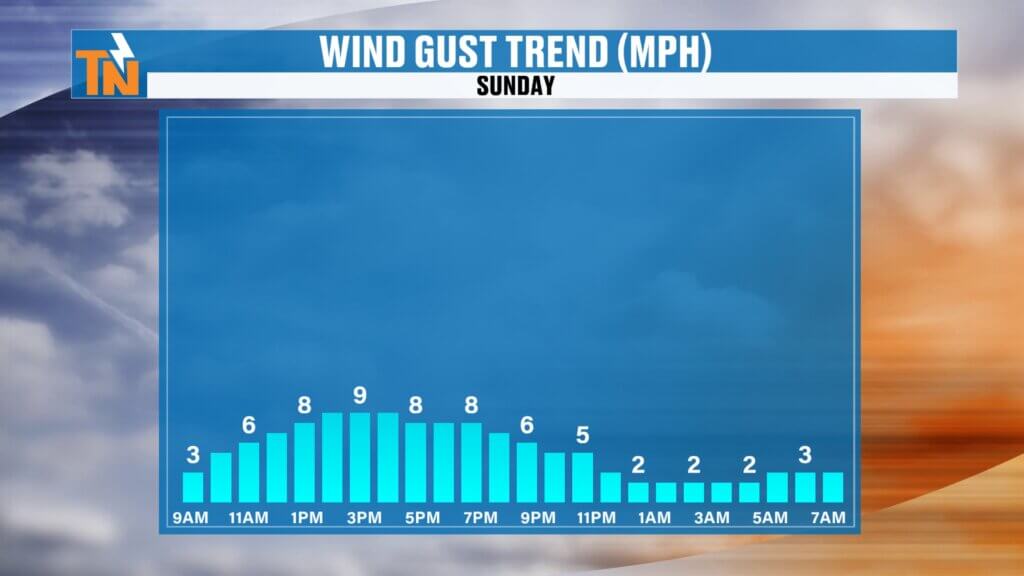
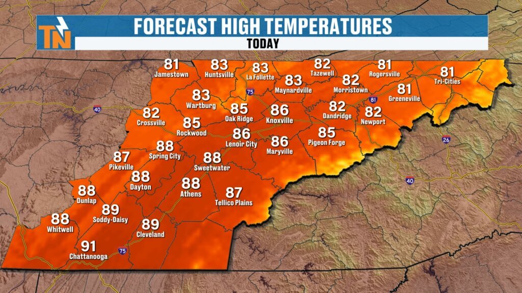
Comfortable Sunday Ahead
Morning temperatures started in the 50s and 60s across much of East Tennessee, with some 70s remaining farther south.
And the drier air will continue working south throughout the day.
Forecast highs will generally reach:
Northern Plateau: Lower 80s
Central Valley/Knoxville: Mid 80s
Southern Valley/Chattanooga: Upper 80s to around 90°
But here’s the important part:
Very little heat index!
The oppressive heat stress we’ve dealt with so much this summer is basically gone today.
So get outside and enjoy it!
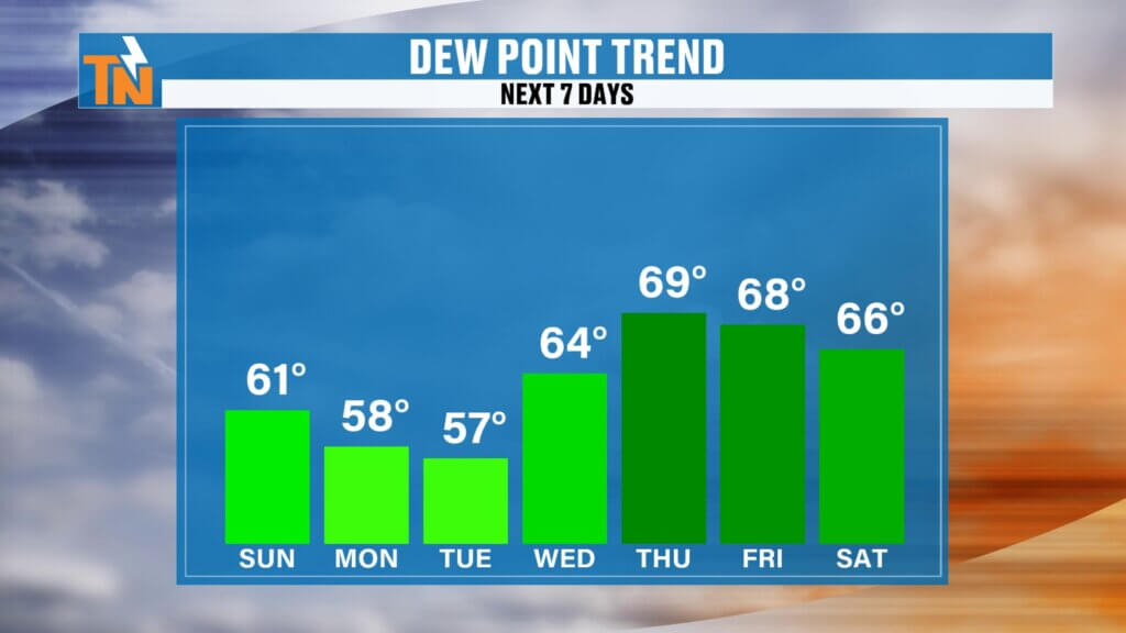
Several Beautiful Days Ahead
This isn’t just a one-day deal, either.
High pressure — or as I like to call it, a big bubble of no trouble — remains in control through the first half of the week.
That gives us a fantastic stretch of weather:
SUNDAY: Sunny, dry and comfortable.
MONDAY: More sunshine with low humidity.
TUESDAY: Another beautiful, dry day.
WEDNESDAY: Still looking great, but moisture begins gradually returning.
If you’re looking for a stretch of weather to get some yard work done, hit the lakes, take an evening walk or just sit outside and enjoy East Tennessee, this is it!
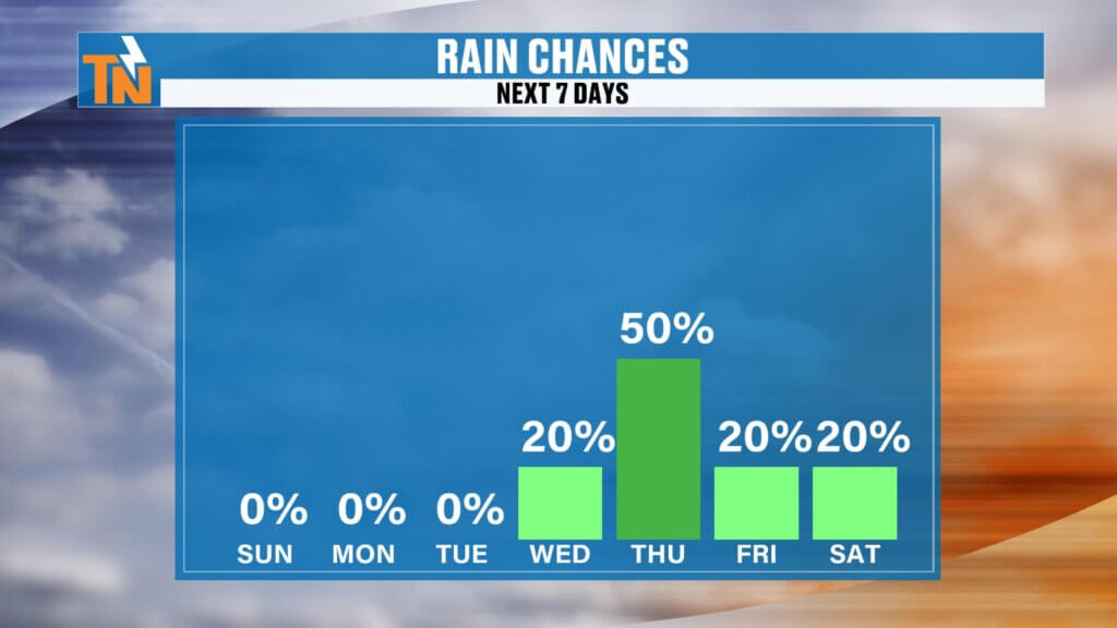
Rain Chances Return Thursday
Eventually, our quiet stretch comes to an end.
Dew points begin climbing again during the middle and latter portions of the week as moisture streams north ahead of our next system.
Another cold front combined with an upper-level disturbance should bring our next opportunity for showers and thunderstorms around Thursday.
That’s currently the day I’m highlighting for the best rain chances.
There are still some timing details to work out, so I’ll continue adjusting that forecast as we get closer.
After Thursday’s system moves through, rain chances should begin decreasing again Friday and into next weekend.
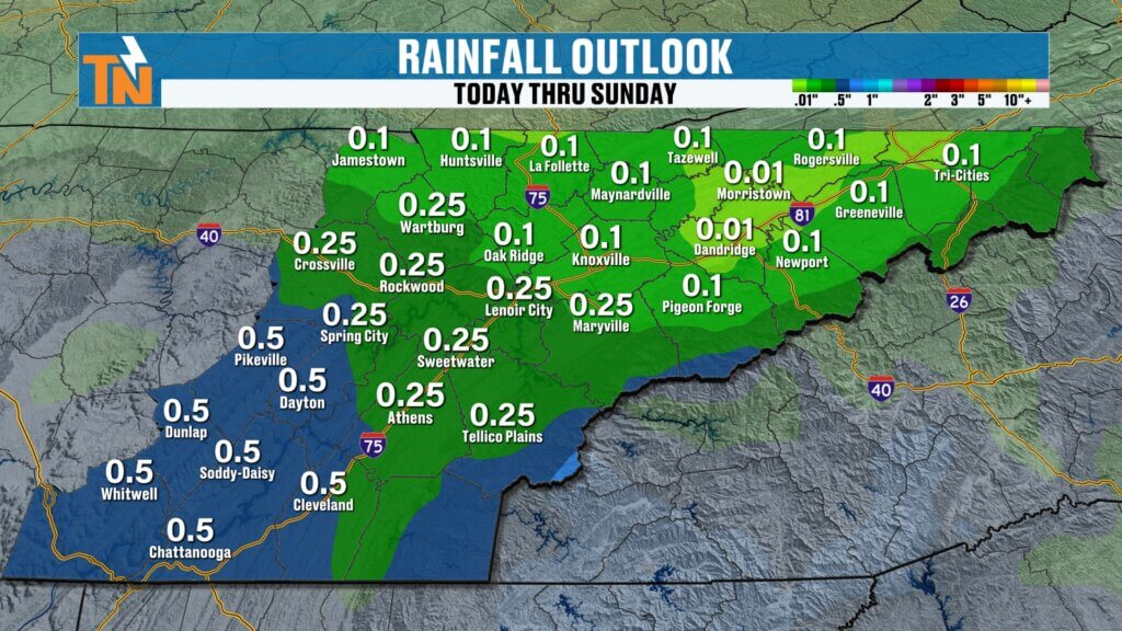
Who Gets The Most Rain?
Looking at rainfall potential over the next seven days, totals aren’t particularly impressive across the entire region.
Areas south of Interstate 40 currently have the better opportunity to receive meaningful rainfall.
Farther north, totals could be considerably lighter.
That’s worth watching because we’re approaching the time of year when East Tennessee typically begins drying out.
September starts that transition, and October is typically our driest month of the year.
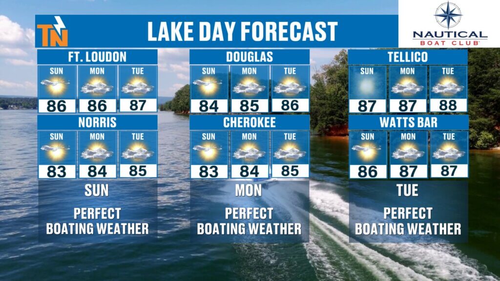
PERFECT Lake Weather
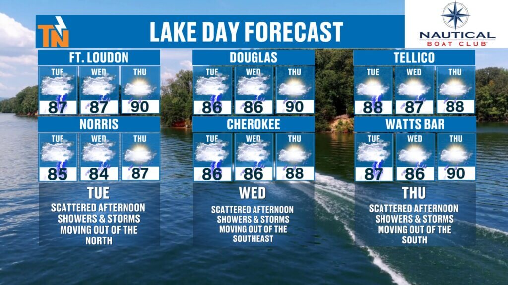
If summer isn’t over in your house yet, you’ve got several fantastic lake days coming up.
SUNDAY: ⭐⭐⭐⭐⭐
MONDAY: ⭐⭐⭐⭐⭐
TUESDAY: ⭐⭐⭐⭐⭐
WEDNESDAY: ⭐⭐⭐⭐
THURSDAY: ⭐⭐ — Showers and thunderstorms return.
Norris, Douglas, Cherokee, Fort Loudoun, Tellico, Watts Bar — take your pick!
The next several days look absolutely fantastic for spending some time on the water.
Looking Toward September — And Winter
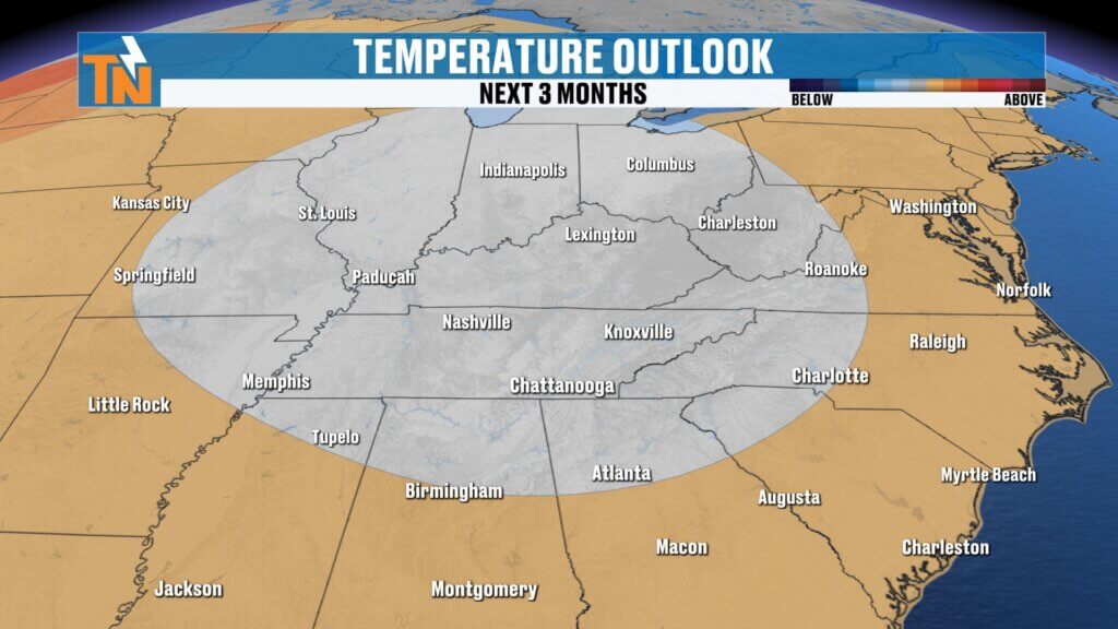
Above and beyond the seven-day forecast, the Climate Prediction Center continues to favor above-average temperaturesas we finish August and begin September.
Rainfall should trend closer to seasonal levels as we move into the beginning of September.
And yes…
I’m already looking at WINTER.
The Climate Prediction Center has released its seasonal winter outlook, and there’s plenty for us to talk about as we look toward the upcoming winter across East Tennessee.
I’ll be breaking that down in upcoming videos and social posts, so make sure you’re following along.
For now, though, forget about winter.
Get outside and enjoy this weather!
Download the FREE eastTNweather app for your local forecast, current conditions, interactive radar and weather alerts wherever you go.
And if you’re watching on YouTube, please LIKE this video, SUBSCRIBE to the channel and hit that bell so you’re notified every time I post a new forecast.
I’m Meteorologist Mike Witcher.
Enjoy this beautiful Sunday, East Tennessee!
eastTNweather — Weather When You Want It.
East Tennessee weather, Knoxville weather, Tennessee weather, Knoxville forecast, East Tennessee forecast, Knoxville weekend weather, East Tennessee humidity, lower humidity Tennessee, Tennessee cold front, East Tennessee cold front, Knoxville temperatures, Chattanooga weather, Tri Cities weather, Cumberland Plateau weather, Smoky Mountains weather, East Tennessee lake forecast, Tennessee winter outlook 2026, East Tennessee winter forecast, Mike Witcher, eastTNweather
#eastTNweather #TNwx #KnoxvilleWeather #EastTennessee #SundayForecast #ColdFront #LowerHumidity #BeautifulWeather #Knoxville #Chattanooga #TriCities #SmokyMountains #LakeWeather #SummerWeather #WinterOutlook #MikeWitcher