
Published: Wednesday, July 29, 2026
By Meteorologist Mike Witcher | eastTNweather
Good Wednesday morning, East Tennessee!
After an incredibly active Tuesday that brought severe thunderstorms, multiple tornado warnings, damaging winds, torrential rainfall, and flash flooding, we’re finally getting a chance to catch our breath. The atmosphere is beginning to settle down, and the next few days will bring much-needed relief before another weather system arrives this weekend.
Tuesday Delivered an Impressive Severe Weather Outbreak
Yesterday’s weather lived up to the forecast.
An extremely unstable atmosphere combined with intense heat and abundant moisture produced explosive thunderstorm development across East Tennessee.
Storms rapidly intensified, prompting:
- Multiple Severe Thunderstorm Warnings
- Several Tornado Warnings
- Numerous Special Weather Statements
- Flash Flood Warnings, especially across the mountain counties
Many of the strongest storms produced towering thunderstorm tops reaching nearly 60,000 feet, an indication of just how powerful yesterday’s updrafts became.
One of the hardest-hit locations was the Camp Creek community in Greene County, where a suspected tornado damaged a barn. Residents also captured remarkable photographs of classic supercell structure—storm formations more commonly seen across the Plains in states like Kansas and Oklahoma than here in East Tennessee.
The National Weather Service will be surveying storm damage over the next couple of days to determine whether tornadoes touched down and to assign official ratings where appropriate. We’ll continue to provide updates as those surveys are completed.
Cooler, Drier Air Finally Arrives
Yesterday’s severe weather developed in an environment that featured:
- High temperatures reaching 95°
- Heat index values exceeding 110° across parts of the Southern Valley
- Extremely high humidity
- An abundance of atmospheric instability
That environment is now changing.
The cold front responsible for Tuesday’s storms continues pushing south, allowing slightly cooler and noticeably drier air to filter into East Tennessee from the north.
While you’ll still notice some lingering humidity this morning—especially across southern sections of the region—you’ll feel a significant difference by this evening.
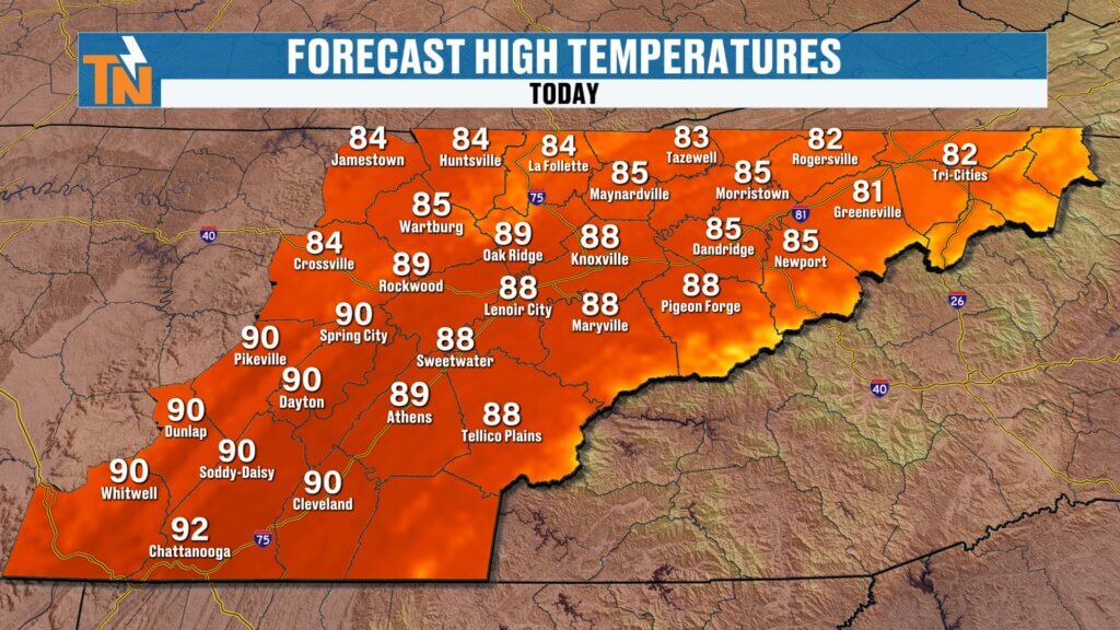
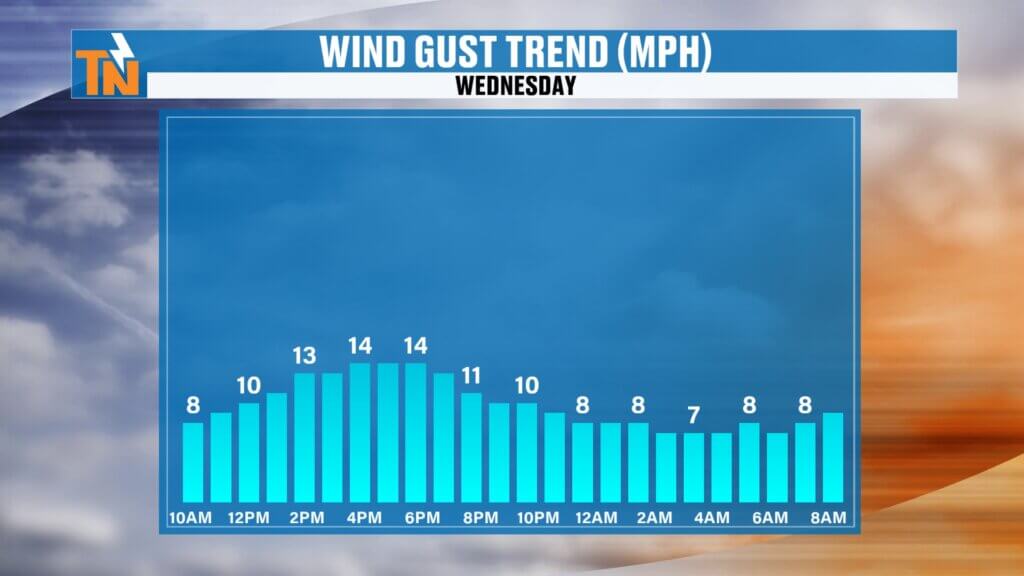
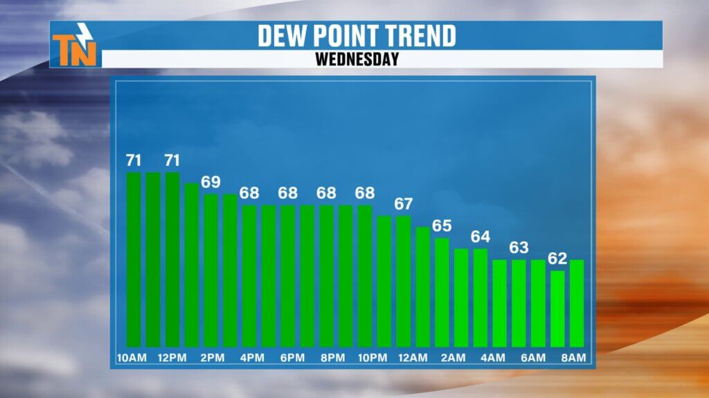
Today’s Forecast
A few areas of patchy fog and lingering low clouds will start the day thanks to yesterday’s heavy rainfall.
As sunshine returns this afternoon:
- High temperatures climb into the upper 80s
- Humidity gradually decreases from north to south
- A light north breeze develops
- No significant rain is expected
It will still be warm, but without the oppressive humidity we’ve experienced recently, conditions will feel much more comfortable by late afternoon and especially this evening.
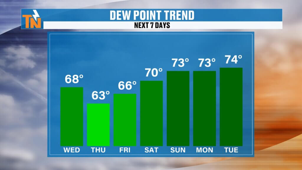
Comfortable Nights Return
One of the biggest changes over the next 24 hours won’t necessarily be the afternoon temperatures—it’ll be the overnight air.
Dew points continue falling today and tonight, meaning:
- Less sticky mornings
- More comfortable evenings
- Lower overnight temperatures
- Lower heat index values
Thursday morning should easily be the most comfortable start we’ve had in quite some time.
Dry Through Friday
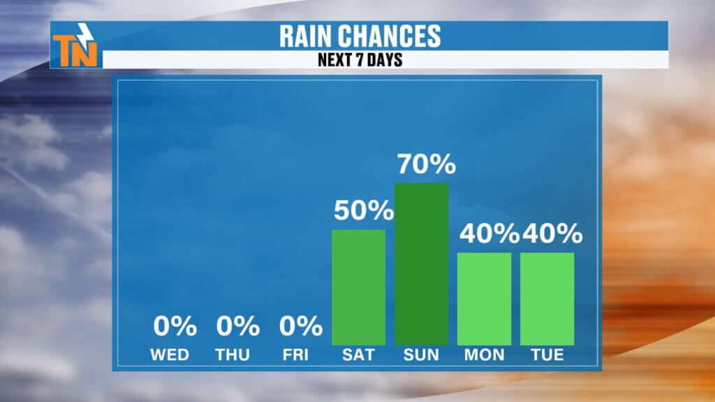
High pressure settles across the Tennessee Valley for the remainder of the workweek.
That means:
- Plenty of sunshine
- Lower humidity
- Comfortable mornings
- Warm afternoons
- Rain-free conditions through Friday
If you’ve been waiting for several beautiful summer days, this is your window.
Weekend Forecast: Rain Chances Return
Unfortunately, the break won’t last long.
Forecast models continue showing another disturbance diving southeast from the Upper Midwest this weekend.
Some guidance even suggests it could evolve into a cutoff upper-level low, which would allow showers and thunderstorms to linger into early next week.
Forecast confidence remains highest that:
- Rain chances increase Saturday.
- Scattered showers and thunderstorms continue Sunday.
- Additional rain may linger into Monday and possibly Tuesday if the cutoff low develops.
We’ll continue refining that forecast over the next couple of days.
Sips of Summer Forecast
If you’re heading to Sips of Summer Friday evening, weather conditions look excellent.
Expect:
- Dry weather
- Comfortable humidity
- Warm temperatures
- Great conditions for an evening outdoors
7-Day Forecast Highlights
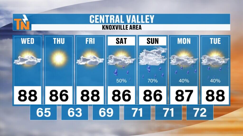
Central Valley (Knoxville)
- Wednesday: 88°, becoming much more comfortable
- Thursday: Mid 80s with the week’s lowest humidity
- Friday: Upper 80s and dry
- Weekend: Mid 80s with scattered showers and thunderstorms
Southern Valley
Still a bit warmer today, with highs near 92°, but humidity drops noticeably tonight. Friday morning may begin with temperatures dipping into the mid-60s before rain chances increase this weekend.
Cumberland Plateau
The coolest stretch arrives Thursday with highs near 82° before clouds and scattered storms return Saturday and Sunday.
Northern Valley & Tri-Cities
Comfortable conditions settle in today with highs in the lower 80s before temperatures gradually climb back into the mid 80s this weekend along with increasing rain chances.
Best Days for the Lake
If you’ve been waiting for ideal boating weather, this is it.
Today, Thursday, and Friday all look fantastic for spending time on East Tennessee lakes with sunshine, lighter humidity, and quiet weather.
Weekend plans don’t necessarily need to be canceled, but you’ll want to monitor the radar as scattered showers and thunderstorms become more common.
Bottom Line
- Tuesday produced widespread severe weather, tornado warnings, flash flooding, and damaging storms.
- Cooler, drier air arrives today and becomes much more noticeable tonight.
- Thursday looks to be the most comfortable day of the week.
- Dry weather continues through Friday.
- Rain and thunderstorm chances increase again this weekend and could linger into early next week.
Be sure to keep the FREE eastTNweather App handy for interactive radar, lightning alerts, watches, warnings, and live severe weather coverage whenever it’s needed.
Have a great Wednesday!
High-Search SEO Keywords
East Tennessee weather, Knoxville weather, severe weather recap, tornado warnings Tennessee, Greene County storm damage, Knoxville forecast, East Tennessee forecast, East Tennessee weather app, flash flooding Tennessee, Knoxville radar, Mike Witcher, Chattanooga weather, Tri-Cities weather, Tennessee weekend forecast
Hashtags
#EastTNWeather #TNwx #KnoxvilleWeather #SevereWeather #StormDamage #TornadoWarning #FlashFlooding #WeatherUpdate #Knoxville #GreeneCounty #WeekendForecast #MikeWitcher #EastTennessee #StayWeatherAware